Menu

Ireland's sailing, boating & maritime magazine

A Harbour Seal photographed at Dun Laoghaire Marina on Dublin Bay, Ireland. Also known as the common seal, is a true seal found along temperate and Arctic marine coastlines of the Northern Hemisphere. The most widely distributed species of pinnipeds, they are found in coastal waters of the northern Atlantic and Pacific oceans, Baltic and North seas. Photo: AfloatA photograph of a Harbour Seal taken at Dun Laoghaire Marina on Dublin Bay, Ireland. Also known as the common seal, this species can be found along temperate and Arctic marine coastlines throughout the Northern Hemisphere. They are the most widely distributed species of pinnipeds and can be found in the coastal waters of the northern Atlantic and Pacific oceans, as well as the Baltic and North Seas. Photo: Afloat

Displaying items by tag: Great South Wall

Dublin’s Great South Wall has taken on the appearance of the Cork Harbour shoreline thanks to a new biodiversity project.

According to RTÉ News, a series of large concrete blocks imprinted with a mould of the Ringaskiddy coastline have been placed at the foot of the wall — providing a rougher topography that is hoped will be a safe haven for marine micro-organisms to thrive.

Researchers at UCD who developed the scheme chose the nooks and crannies on the water’s edge at Ringaskiddy above more than 60 other shorelines, both naturally rocky and human-made, as the model for their project in collaboration with the Dublin Port Company.

And if the Dublin Bay experiment is successful, then Ringaskiddy’s topography could be replicated on sea walls, piers and other structures around the country.

RTÉ News has more on the story HERE.

Published in Dublin Bay

Dublin Port Company has created a splash of colour for the Dublin Pride Festival this week with a new mural installation at the Great South Wall, which attracts over 500 walkers daily.

The Dublin LGBTQ+ Pride Festival 2022 runs until next Tuesday 28 June. However, the whole of June is considered Pride Month with a host of organisations and venues running Pride events across the city and county.

The Dublin Pride Parade and March will take place this Saturday 25 June with over 13,000 people registered to take part and the route runs from O’Connell Street to Merrion Square.

The iconic diving bell on Sir John Rogerson’s Quay will be lit up in rotating Pride colours each evening for the duration of the festival | Credit: Conor McCabe PhotographyThe iconic diving bell on Sir John Rogerson’s Quay will be lit up in rotating Pride colours each evening for the duration of the festival | Credit: Conor McCabe Photography

As part of Dublin Pride 2022, Dublin Port Company has created a new ‘Pride at the Port‘ mural at the Great South Wall which incorporates the pride colours as a symbol of solidarity with our LGBTQ+ community.

Pride flags will fly high throughout Dublin Port and the iconic diving bell on Sir John Rogerson’s Quay will be lit up in the rolling colours of the rainbow each evening at dusk for the duration of the festival.

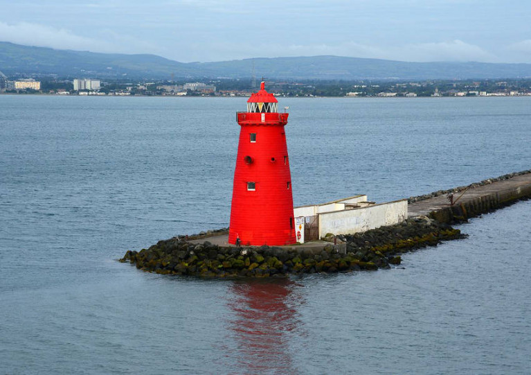
The Great South Wall walk to Poolbeg Lighthouse is a very popular tourist attraction taking in great views of Dublin Bay, with over 180,000 visitors passing the ‘Half Moon’ swimming club over the 12 month period March 2021 to March 2022, the port states.

Published in Dublin Port

Dublin Port Company has announced a temporary closure of pedestrian access to the Great South Wall Due to forecasted high winds and tides in Dublin Bay from tonight, Monday 22 February.

Access will be closed from tonight at 10pm until Wednesday morning, 24 February, at 4am. There is no requirement to close Bull Island Bridge at this time.

The port company says the Great South Wall closure is due to tide height and dangerous winds on the exposed wall surface.

Delays to some shipping activity and pilotage services are also likely, including possible delays at the port’s LOLO container terminals.

Dublin Port Company says it will continue to monitor the situation and provide relevant updates via social media channels and on dublinport.ie

Published in Dublin Port
Tagged under

#PortWalks - Download, walk & listen with the Dublin Port Walks this May Bank Holiday Monday where there is an opportunity to engage with your surroundings on a walk and through a free site specific public artwork. Port Walks is an online audio project connecting Dublin Port Seafarers with Dublin Port Walkers.

On 1st May (10.30-11.30 am) at the Sluice House on the Great South Wall, artist Sheelagh Broderick is holding a public meet up with walkers for a "work in progress" review.

Registered walkers will be invited to download the first of several project podcasts and to listen to it while taking a walk on the Great South Wall. The first podcast addresses the radical reconfiguration of contemporary shipping and seafaring in the last 50 years. Sheelagh will be on hand to answer questions before and afterwards.

The podcast is available for download on portwalks.ie/podcasts as well as other platform providers (iTunes /SoundCloud). Walkers should download content prior to arrival. In the event that anyone has a difficulty with downloads, please come a little earlier than the advertised time for assistance.

Please Register (noting limited numbers) for an available time slot by clicking this link.

Published in Dublin Port

#DublinBay - Dublin Bay was we know it today looked very different three centuries ago, as TheJournal.ie highlights with a selection of enlightening historical maps.

As reported yesterday on Afloat.ie, this week marks the 300th anniversary of the decision to build the Great South Wall in an effort to solve the centuries-old problem of silting in the main channels to Dublin Port.

At that time, the area north of Townsend Street that today is the south Docklands did not exist, as the Liffey flowed right up to what was then called Lazar's Hill or Lazy Hill – while Ringsend was a sandpit that extended into the bay at the river's mouth.

The wall changed all that, as the land between was reclaimed and the Liffey's course straightened and strengthened over the 80 years of its construction.

Later change came to the Northside, too, with the construction of the Bull Wall – surveyed by Captain Bligh of 'Mutiny on the Bounty' infamy – as Marino, Fairview and the North Strand, so named for their then coastal locations, lost their sea views to land reclamation, and Bull Island was formed from the sand and silt that once claimed any number of ships on approach to the city.

The maps have been shared by the Dublin Port Company to coincide with the Dublin Bay Conference that takes place today (Wednesday 29 April) with a programme of lectures lined up to celebrate the construction of what was then the longest sea wall in the world.

Published in Dublin Bay

#DublinPort - Three hundred years ago this week, the decision was made by the Dublin City Assembly to build an embankment from Ringsend into Dublin Bay, in an effort to solve the centuries-old problem of silting in the main channels into Dublin Port.

As RTÉ reports, Philip Bromwell has commemorated this historic occasion with a special multimedia report on the engineering feat, which today extends some 4km to the Poolbeg Lighthouse.

When completed 80 years after plans were first announced, the Great South Wall was the longest sea wall in the world.

And it's still a vital part of the city's infrastructure, helping – along with its sister Bull Wall on the north side of the bay – to keep the port's waters clear of silt and sand build-up for shipping traffic.

But it's also a popular recreation spot for walkers, cyclists, anglers and anyone looking to take in the spectacular vistas of the bay in the shadow of the iconic Poolbeg chimneys.

Get the whole story on the Great South Wall's 300th anniversary HERE.

Published in Dublin Port

For all you need on the Marine Environment - covering the latest news and updates on marine science and wildlife, weather and climate, power from the sea and Ireland's coastal regions and communities - the place to be is Afloat.ie.

Coastal Notes

The Coastal Notes category covers a broad range of stories, events and developments that have an impact on Ireland's coastal regions and communities, whose lives and livelihoods are directly linked with the sea and Ireland's coastal waters.

Topics covered in Coastal Notes can be as varied as the rare finding of sea-life creatures, an historic shipwreck with secrets to tell, or even a trawler's net caught hauling much more than just fish.

Other angles focusing the attention of Coastal Notes are Ireland's maritime museums, which are of national importance to maintaining access and knowledge of our nautical heritage, and those who harvest the sea using small boats based in harbours where infrastructure and safety pose an issue, plying their trade along the rugged wild western seaboard.

Coastal Notes tells the stories that are arguably as varied as the environment they come from, and which shape people's interaction with the natural world and our relationship with the sea.

Marine Wildlife

One of the greatest memories of any day spent boating around the Irish coast is an encounter with Marine Wildlife. It's a thrill for young and old to witness seabirds, seals, dolphins and whales right there in their own habitat. And as boaters fortunate enough to have experienced it will testify, even spotting a distant dorsal fin can be the highlight of any day afloat. Was that a porpoise? Was it a whale? No matter how brief the glimpse, it's a privilege to share the seas with Irish marine wildlife.

Thanks to our location in the North Atlantic, there appears to be no shortage of marine life to observe. From whales to dolphins, seals, sharks and other ocean animals, the Marine Wildlife category documents the most interesting accounts around our shores. And we're keen to receive your observations, your photos, links and video clips, too!

Also valuable is the unique perspective of all those who go afloat, from coastal sailing to sea angling to inshore kayaking to offshore yacht racing, as what they encounter can be of great importance to organisations such as the Irish Whale and Dolphin Group (IWDG). Thanks to their work we now know we share the seas with dozens of species who also call Ireland home. But as impressive as the list is, the experts believe there are still gaps in our knowledge. Next time you are out on the ocean waves, keep a sharp look out!

Weather

As an island in the North Atlantic, Ireland's fate is decided by Weather more so than many other European countries. When storm-force winds race across the Irish Sea, ferry and shipping services are cut off, disrupting our economy. When swollen waves crash on our shores, communities are flooded and fishermen brace for impact - both to their vessels and to their livelihoods.

Keeping abreast of the weather, therefore, is as important to leisure cruisers and fishing crews alike - for whom a small craft warning can mean the difference between life and death - as it is to the communities lining the coast, where timely weather alerts can help protect homes and lives.

Weather affects us all, and Afloat.ie will keep you informed on the hows and the whys.

Marine Science

Perhaps it's the work of the Irish research vessels RV Celtic Explorer and RV Celtic Voyager out in the Atlantic Ocean that best highlights the essential nature of Marine Science for the future growth of Ireland's emerging 'blue economy'.

From marine research to development and sustainable management, Ireland is developing a strong and well-deserved reputation as an emerging centre of excellence. Whether it's Wavebob ocean energy technology to aquaculture to weather buoys and oil exploration, the Marine Science category documents the work of Irish marine scientists and researchers and how they have secured prominent roles in many European and international marine science bodies.

Power From The Sea

The message from the experts is clear: offshore wind and wave energy is the future. And as Ireland looks towards the potential of the renewable energy sector, generating Power From The Sea will become a greater priority in the State's 'blue growth' strategy.

Developments and activities in existing and planned projects in the pipeline from the wind and wave renewables sector, and those of the energy exploration industry, point to the future of energy requirements for the whole world, not just in Ireland. And that's not to mention the supplementary industries that sea power projects can support in coastal communities.

Irish ports are already in a good position to capitalise on investments in offshore renewable energy services. And Power From The Sea can even be good for marine wildlife if done properly.

Aside from the green sector, our coastal waters also hold a wealth of oil and gas resources that numerous prospectors are hoping to exploit, even if people in coastal and island areas are as yet unsure of the potential benefits or pitfalls for their communities.

Changing Ocean Climate

Our ocean and climate are inextricably linked - the ocean plays a crucial role in the global climate system in a number of ways. These include absorbing excess heat from the atmosphere and absorbing 30 per cent of the carbon dioxide added to the atmosphere by human activity. But our marine ecosystems are coming under increasing pressure due to climate change.

The Marine Institute, with its national and international partners, works to observe and understand how our ocean is changing and analyses, models and projects the impacts of our changing oceans. Advice and forecasting projections of our changing oceans and climate are essential to create effective policies and management decisions to safeguard our ocean.

Dr Paul Connolly, CEO of the Marine Institute, said, “Our ocean is fundamental to life on earth and affects so many facets of our everyday activities. One of the greatest challenges we face as a society is that of our changing climate. The strong international collaborations that the Marine Institute has built up over decades facilitates a shared focusing on our changing ocean climate and developing new and enhanced ways of monitoring it and tracking changes over time.

“Our knowledge and services help us to observe these patterns of change and identify the steps to safeguard our marine ecosystems for future generations.”

The Marine Institute’s annual ocean climate research survey, which has been running since 2004, facilitates long term monitoring of the deep water environment to the west of Ireland. This repeat survey, which takes place on board RV Celtic Explorer, enables scientists to establish baseline oceanic conditions in Irish waters that can be used as a benchmark for future changes.

Scientists collect data on temperature, salinity, water currents, oxygen and carbon dioxide in the Atlantic Ocean. This high quality oceanographic data contributes to the Atlantic Ocean Observing System. Physical oceanographic data from the survey is submitted to the International Council for the Exploration of the Seas (ICES) and, in addition, the survey contributes to national research such as the VOCAB ocean acidification and biogeochemistry project, the ‘Clean Atlantic’ project on marine litter and the A4 marine climate change project.

Dr Caroline Cusack, who co-ordinates scientific activities on board the RV Celtic Explorer for the annual survey, said, “The generation of long-term series to monitor ocean climate is vital to allow us understand the likely impact of future changes in ocean climate on ecosystems and other marine resources.”

Other activities during the survey in 2019 included the deployment of oceanographic gliders, two Argo floats (Ireland’s contribution to EuroArgo) and four surface drifters (Interreg Atlantic Area Clean Atlantic project). The new Argo floats have the capacity to measure dissolved ocean and biogeochemical parameters from the ocean surface down to a depth of 2,000 metres continuously for up to four years, providing important information as to the health of our oceans.

During the 2019 survey, the RV Celtic Explorer retrieved a string of oceanographic sensors from the deep ocean at an adjacent subsurface moored station and deployed a replacement M6 weather buoy, as part of the Irish Marine Data Buoy Observation Network (IMDBON).

Funded by the Department of Agriculture, Food and the Marine, the IMDBON is managed by the Marine Institute in collaboration with Met Éireann and is designed to improve weather forecasts and safety at sea around Ireland. The data buoys have instruments which collect weather and ocean data including wind speed and direction, pressure, air and sea surface temperature and wave statistics. This data provides vital information for weather forecasts, shipping bulletins, gale and swell warnings as well as data for general public information and research.

“It is only in the last 20 years, meteorologists and climatologists have really began to understood the pivotal role the ocean plays in determining our climate and weather,” said Evelyn Cusack, Head of Forecasting at Met Éireann. “The real-time information provided by the Irish data buoy network is particularly important for our mariners and rescue services. The M6 data buoy in the Atlantic provides vital information on swell waves generated by Atlantic storms. Even though the weather and winds may be calm around our shores, there could be some very high swells coming in from Atlantic storms.”