Menu

Ireland's sailing, boating & maritime magazine

A Harbour Seal photographed at Dun Laoghaire Marina on Dublin Bay, Ireland. Also known as the common seal, is a true seal found along temperate and Arctic marine coastlines of the Northern Hemisphere. The most widely distributed species of pinnipeds, they are found in coastal waters of the northern Atlantic and Pacific oceans, Baltic and North seas. Photo: AfloatA photograph of a Harbour Seal taken at Dun Laoghaire Marina on Dublin Bay, Ireland. Also known as the common seal, this species can be found along temperate and Arctic marine coastlines throughout the Northern Hemisphere. They are the most widely distributed species of pinnipeds and can be found in the coastal waters of the northern Atlantic and Pacific oceans, as well as the Baltic and North Seas. Photo: Afloat

Displaying items by tag: disruption

Schoolchildren in their hundreds are facing disruption as the Strangford Lough ferry in Co. Down is to be affected over the next seven days due to strike action by ferry workers.

The passenger car-ferry service that links the villages of Strangford and Portaferry will not be operational for a week.

This means that commuters also will have to find an alternative method of transport as the service which has two car-ferries, Strangford II and Portaferry II (as above) are out of service.

According to BBC News a school principal said that four of his pupils will be left without any way of getting to school.

Members of the union, Unite, have voted to take strike-action after rejecting a pay offer of £552 extra per year for workers.

Commenting on the strike, Sharon Graham, Unite general secretary said the offer was a "slap in the face" for those responsible for the maintenance of vital public services and infrastructure.

It was on Thursday, at 00:01 (BST) that the strike had begun and is to continue into next week up until 23.59 on 26 April, Wednesday. For updated information visit the TravelWatchNI website here.

More here on the strike at the Strangford Lough Ferry Service which Afloat adds is operated by the Department for Infrastructure (DfI)'s Roads Division South, a Northern Ireland Government Department.

The road distance between Strangford and Portaferry is 46 miles and takes on average 30 minutes to drive. Whereas the ferry route of less than 1 nautical mile takes around 8 minutes to complete.

Published in Ferry

Sailing disruptions of the Isle of Man Steam Packet Company have been confirmed by the ferry operator with schedules over the next few days, as work is completed to resolve mechanical issues affecting one of the linkspans at Douglas Harbour.

Following an initial inspection by Department of Infrastructure and Steam Packet engineers, it is estimated rectification will take at least until the end of this week.

According to the Steam Packet, both Ben-my-Chree and Manannan will be utilising the King Edward VIII Pier (story) linkspan, initially with the 02:15 sailing from Heysham which will be rescheduled to 01:45. This will enable Ben-my-Chree to arrive on berth in Douglas at 05:45.

The early arrival of the Heysham-Douglas sailing will relieve some of the congestion in the harbour of Manx capital by allowing Ben-my-Chree to discharge before moving off berth to facilitate Manannan’s loading and departure. Ben-my-Chree will then return to the linkspan to load and depart on the scheduled 08:45 sailing.

The Isle of Man Steam Packet Company is working closely with colleagues at the Isle of Man Government’s Department of Infrastructure’s Harbours division to resolve the mechanical issues as quickly as possible

Until the situation is resolved all sailings will operate from the functional linkspan.

All passengers booked on any affected sailings will be informed.

Published in Ferry
Tagged under

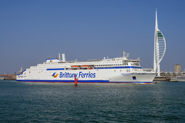
Asides delays to Stait of Dover ferry operators as Afloat reported, Brittany Ferries UK crossings to Spain and France are set to be disrupted after a new liquefied gas-powered (LNG) ship broke down days after its inaugural voyage.

Brittany Ferries said an engine fault delayed the departure from Bilbao of its Salamanca ferry by 26 hours.

The vessel powered by LNG, yesterday reported BBC News, was hailed as being cleaner and reducing emissions.

It is due to return to Portsmouth at 22:00 BST with knock-on delays expected for future sailings.

In a statement, the company said the fault was discovered during embarkation for Salamanca's 18:00 departure from Bilbao to Portsmouth.

For more on the first LNG ferry to operate out of the UK, click here.

Last month Afloat reported of Brittany Ferries seasonal Ireland-France route of Cork-Roscoff which resumed service almost a week ago by Armorique.    

Published in Brittany Ferries

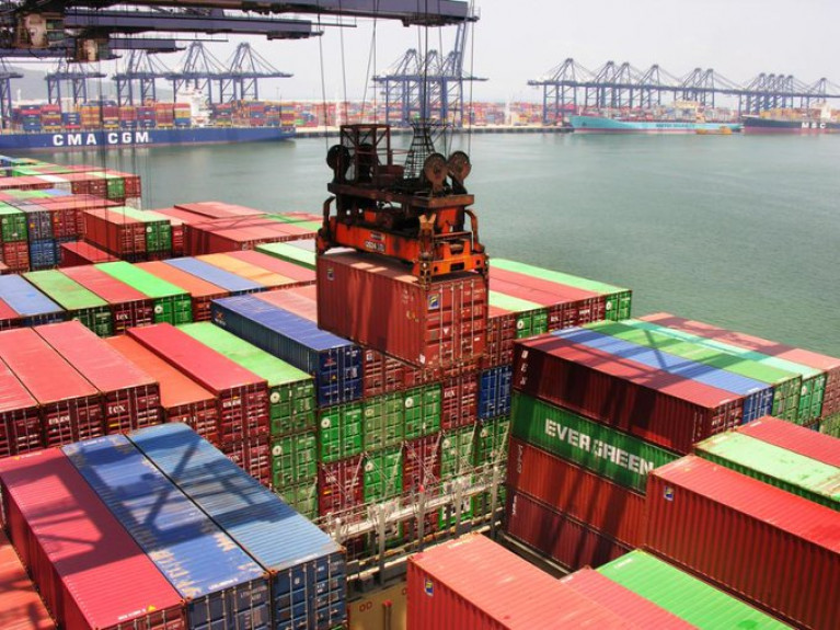
Disruption caused by the partial closure of the key south China Port of Yantian and its impact is set to exceed that of the Suez Canal blockage in late March and April, according to senior container shipping sources, with the ripple effects already being felt across supply chains.

According to LloydsLoadingList, container shipping industry commentator Lars Jensen, CEO of shipping consultancy Vespucci Maritime, observed that it “clearly currently appears that supply chain problems are worsening and not improving”. He highlighted that “the impact of the South China port issues continues to escalate”, and that the proportion of vessels affected “exceed the Suez incident”.

Taking a “quick look at four carriers, across each of the major alliances”, he yesterday highlighted that Maersk now advises that 64 of its vessels or its partner vessels in the 2M alliance have omitted Yantian and Shekou, with six switching to call in Nansha or Hong Kong, noting that “this is up from 40 vessels listed just two days ago”.

He notes that ONE now advises that 52 of THE Alliance’s vessels are being impacted, with 41 omissions and 11 changes typically from Yantian to Nansha – up from 27 vessels, of which 20 were omissions and seven were port changes, in their last advisory 5 days ago.

More here on this impact to global trade.

Published in Ports & Shipping

Customers in their thousands due to travel with Brittany Ferries are facing holiday disruption with the company's flagship Pont-Aven ferry now out of action until June 14.

The cruise-ferry, writes Independent.ie, which sails from Cork to Roscoff in France, has been out of service since May 17 to facilitate repairs to a fault.

"Despite these efforts it has now become apparent that this work will take longer than initially planned, whilst replacement parts are delivered and installed, and comprehensive checks are carried out," the company has announced.

The Pont Aven will not resume sailings until Friday, June 14.

For passengers, that means sailings on the Cork/Roscoff route have been cancelled for this weekend (May 31/June 1) and next (June7/8), along with a number of sailings on the company’s Plymouth/Santander and Plymouth/Roscoff routes.

Since May 17, a total of some 6,500 customers will be affected.

For more on the story click here including a Q&A link about what are my rights if my ferry is cancelled or delayed? 

Published in Brittany Ferries
Northern Ireland is recovering after Hurricane Katia left power cuts and travel distruption in its wake.
As previously reported on Afloat.ie, the remains of Hurrican Katia had been expected to strike hardest in the northern half of Ireland.
The Belfast Telegraph reports that Derry, Antrim and Tyrone were worst hit by winds that reached speeds of up to 120kph on Monday.
There was widespread disruption to rail and ferry services, while drivers reported hazardous conditions. The Foyle Bridge was closed to all high-sided vehiches for a time.
Some 700 homes across Northern Ireland suffered a blackout when powerlines were cut and by falling trees and windborne debris, though power was mostly restored by Tuesday evening.
Though downgraded to tropical storm status after crossing the Atlantic, Katia's high winds wreaked similar havoc south of the border, with power cuts to over 13,000 homes in six different counties - half of them in Donegal alone.
Wind gusts of an incredible 137kmh were recorded on Arranmore Island.
The Belfast Telegraph has more on the story HERE.

Northern Ireland is recovering after Hurricane Katia left power cuts and travel distruption in its wake.

As previously reported on Afloat.ie, the remains of Hurrican Katia had been expected to strike hardest in the northern half of Ireland.

The Belfast Telegraph reports that Derry, Antrim and Tyrone were worst hit by winds that reached speeds of up to 120kph on Monday.

There was widespread disruption to rail and ferry services, while drivers reported hazardous conditions. The Foyle Bridge was closed to all high-sided vehiches for a time.

Some 700 homes across Northern Ireland suffered a blackout when powerlines were cut and by falling trees and windborne debris, though power was mostly restored by Tuesday evening.

Though downgraded to tropical storm status after crossing the Atlantic, Katia's high winds wreaked similar havoc south of the border, with power cuts to over 13,000 homes in six different counties - half of them in Donegal alone.

Wind gusts of an incredible 137kmh were recorded on Arranmore Island.

The Belfast Telegraph has more on the story HERE.

Published in Weather

For all you need on the Marine Environment - covering the latest news and updates on marine science and wildlife, weather and climate, power from the sea and Ireland's coastal regions and communities - the place to be is Afloat.ie.

Coastal Notes

The Coastal Notes category covers a broad range of stories, events and developments that have an impact on Ireland's coastal regions and communities, whose lives and livelihoods are directly linked with the sea and Ireland's coastal waters.

Topics covered in Coastal Notes can be as varied as the rare finding of sea-life creatures, an historic shipwreck with secrets to tell, or even a trawler's net caught hauling much more than just fish.

Other angles focusing the attention of Coastal Notes are Ireland's maritime museums, which are of national importance to maintaining access and knowledge of our nautical heritage, and those who harvest the sea using small boats based in harbours where infrastructure and safety pose an issue, plying their trade along the rugged wild western seaboard.

Coastal Notes tells the stories that are arguably as varied as the environment they come from, and which shape people's interaction with the natural world and our relationship with the sea.

Marine Wildlife

One of the greatest memories of any day spent boating around the Irish coast is an encounter with Marine Wildlife. It's a thrill for young and old to witness seabirds, seals, dolphins and whales right there in their own habitat. And as boaters fortunate enough to have experienced it will testify, even spotting a distant dorsal fin can be the highlight of any day afloat. Was that a porpoise? Was it a whale? No matter how brief the glimpse, it's a privilege to share the seas with Irish marine wildlife.

Thanks to our location in the North Atlantic, there appears to be no shortage of marine life to observe. From whales to dolphins, seals, sharks and other ocean animals, the Marine Wildlife category documents the most interesting accounts around our shores. And we're keen to receive your observations, your photos, links and video clips, too!

Also valuable is the unique perspective of all those who go afloat, from coastal sailing to sea angling to inshore kayaking to offshore yacht racing, as what they encounter can be of great importance to organisations such as the Irish Whale and Dolphin Group (IWDG). Thanks to their work we now know we share the seas with dozens of species who also call Ireland home. But as impressive as the list is, the experts believe there are still gaps in our knowledge. Next time you are out on the ocean waves, keep a sharp look out!

Weather

As an island in the North Atlantic, Ireland's fate is decided by Weather more so than many other European countries. When storm-force winds race across the Irish Sea, ferry and shipping services are cut off, disrupting our economy. When swollen waves crash on our shores, communities are flooded and fishermen brace for impact - both to their vessels and to their livelihoods.

Keeping abreast of the weather, therefore, is as important to leisure cruisers and fishing crews alike - for whom a small craft warning can mean the difference between life and death - as it is to the communities lining the coast, where timely weather alerts can help protect homes and lives.

Weather affects us all, and Afloat.ie will keep you informed on the hows and the whys.

Marine Science

Perhaps it's the work of the Irish research vessels RV Celtic Explorer and RV Celtic Voyager out in the Atlantic Ocean that best highlights the essential nature of Marine Science for the future growth of Ireland's emerging 'blue economy'.

From marine research to development and sustainable management, Ireland is developing a strong and well-deserved reputation as an emerging centre of excellence. Whether it's Wavebob ocean energy technology to aquaculture to weather buoys and oil exploration, the Marine Science category documents the work of Irish marine scientists and researchers and how they have secured prominent roles in many European and international marine science bodies.

Power From The Sea

The message from the experts is clear: offshore wind and wave energy is the future. And as Ireland looks towards the potential of the renewable energy sector, generating Power From The Sea will become a greater priority in the State's 'blue growth' strategy.

Developments and activities in existing and planned projects in the pipeline from the wind and wave renewables sector, and those of the energy exploration industry, point to the future of energy requirements for the whole world, not just in Ireland. And that's not to mention the supplementary industries that sea power projects can support in coastal communities.

Irish ports are already in a good position to capitalise on investments in offshore renewable energy services. And Power From The Sea can even be good for marine wildlife if done properly.

Aside from the green sector, our coastal waters also hold a wealth of oil and gas resources that numerous prospectors are hoping to exploit, even if people in coastal and island areas are as yet unsure of the potential benefits or pitfalls for their communities.

Changing Ocean Climate

Our ocean and climate are inextricably linked - the ocean plays a crucial role in the global climate system in a number of ways. These include absorbing excess heat from the atmosphere and absorbing 30 per cent of the carbon dioxide added to the atmosphere by human activity. But our marine ecosystems are coming under increasing pressure due to climate change.

The Marine Institute, with its national and international partners, works to observe and understand how our ocean is changing and analyses, models and projects the impacts of our changing oceans. Advice and forecasting projections of our changing oceans and climate are essential to create effective policies and management decisions to safeguard our ocean.

Dr Paul Connolly, CEO of the Marine Institute, said, “Our ocean is fundamental to life on earth and affects so many facets of our everyday activities. One of the greatest challenges we face as a society is that of our changing climate. The strong international collaborations that the Marine Institute has built up over decades facilitates a shared focusing on our changing ocean climate and developing new and enhanced ways of monitoring it and tracking changes over time.

“Our knowledge and services help us to observe these patterns of change and identify the steps to safeguard our marine ecosystems for future generations.”

The Marine Institute’s annual ocean climate research survey, which has been running since 2004, facilitates long term monitoring of the deep water environment to the west of Ireland. This repeat survey, which takes place on board RV Celtic Explorer, enables scientists to establish baseline oceanic conditions in Irish waters that can be used as a benchmark for future changes.

Scientists collect data on temperature, salinity, water currents, oxygen and carbon dioxide in the Atlantic Ocean. This high quality oceanographic data contributes to the Atlantic Ocean Observing System. Physical oceanographic data from the survey is submitted to the International Council for the Exploration of the Seas (ICES) and, in addition, the survey contributes to national research such as the VOCAB ocean acidification and biogeochemistry project, the ‘Clean Atlantic’ project on marine litter and the A4 marine climate change project.

Dr Caroline Cusack, who co-ordinates scientific activities on board the RV Celtic Explorer for the annual survey, said, “The generation of long-term series to monitor ocean climate is vital to allow us understand the likely impact of future changes in ocean climate on ecosystems and other marine resources.”

Other activities during the survey in 2019 included the deployment of oceanographic gliders, two Argo floats (Ireland’s contribution to EuroArgo) and four surface drifters (Interreg Atlantic Area Clean Atlantic project). The new Argo floats have the capacity to measure dissolved ocean and biogeochemical parameters from the ocean surface down to a depth of 2,000 metres continuously for up to four years, providing important information as to the health of our oceans.

During the 2019 survey, the RV Celtic Explorer retrieved a string of oceanographic sensors from the deep ocean at an adjacent subsurface moored station and deployed a replacement M6 weather buoy, as part of the Irish Marine Data Buoy Observation Network (IMDBON).

Funded by the Department of Agriculture, Food and the Marine, the IMDBON is managed by the Marine Institute in collaboration with Met Éireann and is designed to improve weather forecasts and safety at sea around Ireland. The data buoys have instruments which collect weather and ocean data including wind speed and direction, pressure, air and sea surface temperature and wave statistics. This data provides vital information for weather forecasts, shipping bulletins, gale and swell warnings as well as data for general public information and research.

“It is only in the last 20 years, meteorologists and climatologists have really began to understood the pivotal role the ocean plays in determining our climate and weather,” said Evelyn Cusack, Head of Forecasting at Met Éireann. “The real-time information provided by the Irish data buoy network is particularly important for our mariners and rescue services. The M6 data buoy in the Atlantic provides vital information on swell waves generated by Atlantic storms. Even though the weather and winds may be calm around our shores, there could be some very high swells coming in from Atlantic storms.”