Menu

Ireland's sailing, boating & maritime magazine

A Harbour Seal photographed at Dun Laoghaire Marina on Dublin Bay, Ireland. Also known as the common seal, is a true seal found along temperate and Arctic marine coastlines of the Northern Hemisphere. The most widely distributed species of pinnipeds, they are found in coastal waters of the northern Atlantic and Pacific oceans, Baltic and North seas. Photo: AfloatA photograph of a Harbour Seal taken at Dun Laoghaire Marina on Dublin Bay, Ireland. Also known as the common seal, this species can be found along temperate and Arctic marine coastlines throughout the Northern Hemisphere. They are the most widely distributed species of pinnipeds and can be found in the coastal waters of the northern Atlantic and Pacific oceans, as well as the Baltic and North Seas. Photo: Afloat

Displaying items by tag: torpedo

#torpedo – An investigation is under way after a 9ft–missile was fired from HMS Argyll at high security Plymouth nuclear submarine dockyard during a training drill this week. 

A Royal Navy spokesman said: "We can confirm an incident occurred onboard HMS Argyll on Wednesday, March 12, at 3.24pm, while the ship was alongside at Devonport Naval Base in Plymouth.

"During a training exercise, an inert Test Variant Torpedo (TVT) unexpectedly jettisoned onto the wharf. There was no explosion and no casualties.

A source said: "The torpedo came shooting out of the side of Argyll and flew through the air before going straight through a security fence.

"It's carried on going before hitting a storage container. If anyone was inside it they would have a had a nasty shock - the whole side of the container was stoved in.

The Telegraph has much more on the story here.

Published in News Update

#Torpedo - Taoiseach Enda Kenny had paid tribute to the Castlebar-born inventor of the steerable torpedo at the unveiling of a headstone on Louis Brennan's grave in London.

As the Irish Independent reports, Brennan - who lived from 1852 to 1932 - was a renowned inventor, credited with developing the world's first practical guided missile that he patented as the 'Brennan Torpedo', and tested at Fort Camden in Cork Harbour in the late 1870s.

Raised in Melbourne, Australia, Brennan spent much of his working life in Britain inventing for the military, developing such concepts as a revolutionary monorail system that attracted the attention of Winston Churchill.

However, following his death in a car accident in Switzerland, Brennan lay in an unmarked grave in Kensal Green, northwest London.

Now a group of history buffs from Brennan's Mayo birthplace have finally marked that spot with a headstone, as well as a plaque commemorating his life and achievements in the cemetery's oratory.

"I am pleased today that we have this opportunity to restore and publicly acknowledge the resting place of Louis Brennan," said the Taoiseach at the unveiling ceremony yesterday (11 March).

"But also, in a sense, to redeem ourselves in that we left him here alone unknown for so long."

The Irish Independent has more on the story HERE.

Published in News Update
Tagged under

#INLAND WATERWAYS - As Derek Evans writes in The Irish Times, the recent discovery of the first Guinness merchant vessel - sunk a century ago by a German torpedo in the Irish Sea - rekindled memories of the brewery's boats on the Liffey in the 1950s.

He writes: "Living close to Stoneybatter, I often took time to stand on Queen Street Bridge as the barges, filled with Guinness barrels, slowly made their way from James’s Gate to Sir John Rogerson’s Quay.

"I remember clearly the skipper standing beside the open wheelhouse in his navy blue polo-neck jumper, captain’s hat and pipe... The skipper always had a smile and a wave before he would disappear for a few moments under the white cloud."

He also recalls the hoisting of the barrells at Butt Bridge onto the Guinness cargo vessels - like the WM Barkley, the Lady Grania or Gwendolen Guinness - for transport to Liverpool.

As previously reported on Afloat.ie, the wreck of the WM Barkley was captured in high-resolution images taken from the national research vessel RV Celtic Voyager off the coast of Dublin.

The Irish Times has more on the story HERE.

Published in Inland Waterways
High Resolution images of a merchant ship which was sunk ninety-four years ago today (October 12th) off the coast of Dublin have been revealed by the INFOMAR (Integrated Mapping For the Sustainable Development of Ireland's Marine Resource) Programme during a mission on the national research vessel the RV Celtic Voyager earlier this year which surveyed the wreck of the first Guinness merchant vessel, the W.M. Barkley.

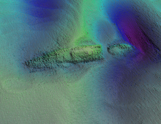
The detailed seabed images, which include deck features and complex sand wave structures, were recorded by towed sidescan sonar provided by the Moore Marine Group, and give a visual insight into the defensively armed ship that was sunk by a German torpedo in 1917, seven miles east of the Kish Bank off Dublin.

Photo_1_INFOMAR_image_of_W_M_Barkley_from_port_aft

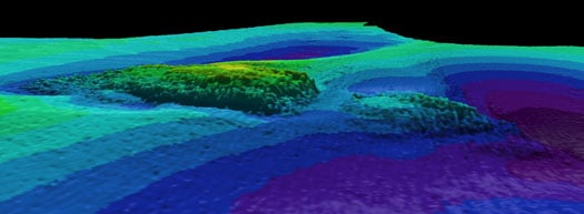
Photos above and below show topographic seafloor images in 3D, showing the partially buried wreck of the W M Barkley lying at a water depth of 56 metres; with deeper scouring around it down to 72 metres (darker colours indicate greater depths). The images were created from sonar data acquired onboard the Marine Institute's research vessel RV Celtic Voyager, during INFOMAR Programme mapping in 2010 and 2011 with data processed by INFOMAR's Fabio Sacchetti (University of Ulster) and Charise McKeon (Geological Survey of Ireland).

W_M_Barkley

In May 2010, during a large scale mapping survey in the Irish Sea by INFOMAR, a national marine study run by the Marine Institute and the Geological Survey of Ireland, identified a seabed feature which, to the trained eye, was discernable as a potential shipwreck lying in the same position recorded on the Admiralty Chart, the EU wreck site and UK Hydrographic Office wreck site directories, as well as a survey conducted in the 1980s as the last known position of the W.M.Barkley.

Viewing the spectacular imagery of the shipwreck Minister for Communications, Energy & Natural Resources, Pat Rabbitte, said "I am delighted to note the continued excellence of the valuable work being carried out under the INFOMAR project. These images from the deep reveal a unique view of part of Ireland's marine heritage and I am delighted to announce details of INFOMAR''s annual seminar to be held in Galway on November 16 and 17th."

Photo_3_Guinness_Archivist_Eibhlin_Roche_with_model_of_WM_Barkley

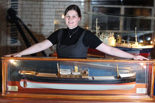
Eibhlin Roche - Guinness Archivist, Guinness Storehouse with the model of the W.M. Barkley. Photo: Jason Clarke Photography

Ninety four years ago on the dark night of October 12th 1917 the W.M.Barkley was torpedoed without warning by the German submarine UC-75. Within minutes the ship, which was owned and operated by the Guinness Company of Dublin, broke in two and sank, taking with her to the bottom four men including her Captain and leaving the rest of her crew to face the sea in an open lifeboat. Now, the darkness where the ship has lain in pieces has been disturbed, probed by fingers of sound that are mapping the seabed in incredible details and bringing to light the position of this famous Irish shipwreck.

"As the first Guinness owned ship, the W.M. Barkley played an important role in the story of the transportation of GUINNESS beer overseas," said Eibhlin Roche, Guinness Archivist. The events of the night of 12th October 1917 are very much part of the history of Guinness that is recorded in the Guinness Archive. It is exciting to finally know the exact resting place of the W.M. Barkley."

A scale model of the W.M. Barkley is on display in the Transport Gallery of Guinness Storehouse remembering the lives of the Guinness men who both perished and survived the events of 12th October 1917. These are stories of tragedy and bravery portraying Irish traditional values, and how they were brought to light with the application of cutting-edge technology.

Koen_Verbruggen_Minister_Rabbitte_Dr_Peter_Heffernan_Eibhlin_Roche_and_David_Smith

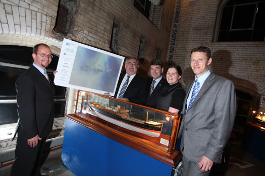
Koen Verbruggen (GSI), Minister Pat Rabbitte, Dr. Peter Heffernan (CEO, Marine Institute), Eibhlin Roche (Guinness Archivist, Guinness Storehouse) and David Smith (Country Director, Diageo Ireland) Photo: Jason Clarke Photography


Published in Marine Science
American Gregg Bemis is headed to Ireland for what may be the last major dive to the wreck of the Lusitania.
Bemis, who owns the wreck of the former Cunard cruise liner torpedoed off the Cork coast in 1915, told The Irish Times that hopes to discover once and for all what was in the cargo hold of the ship - and give an answer to rumours that precious art and munitions were part of the manifest.
The millionaire has fought with the Irish State over the rights to the wreck site, to which he has dived twice before, but now he has full licence and access to the latest technology to unveil the Lusitania's deepest secrets.
The Irish Times has more on the story HERE.

American Gregg Bemis is headed to Ireland for what may be the last major dive to the wreck of the Lusitania.

Bemis, who owns the wreck of the former Cunard cruise liner torpedoed off the Cork coast in 1915, told The Irish Times that hopes to discover once and for all what was in the cargo hold of the ship - and give an answer to rumours that precious art and munitions were part of the manifest.

The millionaire has fought with the Irish State over the rights to the wreck site, to which he has dived twice before, but now he has full licence and access to the latest technology to unveil the Lusitania's deepest secrets.

The Irish Times has more on the story HERE.

Published in Coastal Notes

Scuba Divers have found a fully intact World War I U-Boat on the seabed just outside Cork harbour, some 93 years after it sank writes Timmy Carey.

During the First World War the menace provided by German U-Boats would prove deadly to the Allies and were responsible for sinking millions of tons of shipping; indeed German U-Boats almost changed the course of the war. Most allied ships sunk by U-boats were sunk by either torpedo, deck gunfire or explosives placed aboard the ship by U-boat crew. A smaller number of ships were also sunk by mine laying U-boats; one of these being UC42. On the 10th of September of 1917 UC42 was laying her deadly cargo of mines at the entrance to Cork harbour when a terrific explosion occurred which resulted in a grim death for all 27 German Submariners aboard.

As the submarine sank to the seabed the German submariners were trapped inside UC42, which would soon become their metal tomb.

On November  2nd of that year, hardhat divers from the Haulbowline dockyard dived the area and positively identified the U-boat as UC42, noting the stern damage to the submarine and the presence of the bodies of some of the German submariners. During 1918 the submarine was dived by Haulbowline and American divers in an effort to disarm all the mines and torpedoes still aboard, with USS Melville taking three of the mines. It was widely believed that in July 1919 divers using explosives from HMS Vernon torpedo school had destroyed the submarine with the remains being dispersed on the seabed by wire sweeps.

With the advent of scuba diving many divers have since searched for the scattered remains of UC42 around Cork harbour with no luck until a recent dive by two local divers Ian Kelleher and Niall O Regan descended a shot line to see the menacing sight of the hull of a German U-boat emerge from the shadows. Both divers were very surprised and ecstatic to find a fully intact World War I U-Boat in 27 meters of water just outside Cork harbour in good condition with little obvious explosive damage from the British naval dive team.

A local dive team of five divers had spent the previous 12 months carrying out a careful methodical search of the greater harbour area determined to find the remains of the submarine; their hard labours finally paying dividends when Niall and Ian identified the presence of the submarine. The dive team consisted of Ian Kelleher, Niall O Regan, Philip Johnston,  Eoin Mc Garry and Timmy Carey.

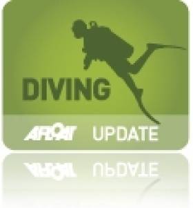
Over the past few weeks the divers have carefully and methodically videoed and photographed the Submarine and taken various measurements to record the wrecks' condition. Over a number of dives the dive team carefully cleaned the growth from the propeller and after some methodical cleaning found the U-Boats number UC42 stamped into it; positively identifying the submarine.

As the submarine is a war grave and contains the remains of so many young German submariners the dive team also laid a plaque of remembrance, which was erected near the submarines propellers; to act as a memorial to the German submariners forever entombed in UC42. The plaque was kindly donated to the dive team by John O' Mahony of Complete Signs.

IMG_60751

The image of the U-Boats propellor with the markings identifying the U-Boat. Photo: Timmy Carey

mine

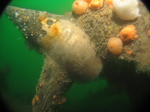
A badly decayed mine on UC42 still in the mine chute. Photo: Timmy Carey

RTE News Video clip here

Published in Diving

For all you need on the Marine Environment - covering the latest news and updates on marine science and wildlife, weather and climate, power from the sea and Ireland's coastal regions and communities - the place to be is Afloat.ie.

Coastal Notes

The Coastal Notes category covers a broad range of stories, events and developments that have an impact on Ireland's coastal regions and communities, whose lives and livelihoods are directly linked with the sea and Ireland's coastal waters.

Topics covered in Coastal Notes can be as varied as the rare finding of sea-life creatures, an historic shipwreck with secrets to tell, or even a trawler's net caught hauling much more than just fish.

Other angles focusing the attention of Coastal Notes are Ireland's maritime museums, which are of national importance to maintaining access and knowledge of our nautical heritage, and those who harvest the sea using small boats based in harbours where infrastructure and safety pose an issue, plying their trade along the rugged wild western seaboard.

Coastal Notes tells the stories that are arguably as varied as the environment they come from, and which shape people's interaction with the natural world and our relationship with the sea.

Marine Wildlife

One of the greatest memories of any day spent boating around the Irish coast is an encounter with Marine Wildlife. It's a thrill for young and old to witness seabirds, seals, dolphins and whales right there in their own habitat. And as boaters fortunate enough to have experienced it will testify, even spotting a distant dorsal fin can be the highlight of any day afloat. Was that a porpoise? Was it a whale? No matter how brief the glimpse, it's a privilege to share the seas with Irish marine wildlife.

Thanks to our location in the North Atlantic, there appears to be no shortage of marine life to observe. From whales to dolphins, seals, sharks and other ocean animals, the Marine Wildlife category documents the most interesting accounts around our shores. And we're keen to receive your observations, your photos, links and video clips, too!

Also valuable is the unique perspective of all those who go afloat, from coastal sailing to sea angling to inshore kayaking to offshore yacht racing, as what they encounter can be of great importance to organisations such as the Irish Whale and Dolphin Group (IWDG). Thanks to their work we now know we share the seas with dozens of species who also call Ireland home. But as impressive as the list is, the experts believe there are still gaps in our knowledge. Next time you are out on the ocean waves, keep a sharp look out!

Weather

As an island in the North Atlantic, Ireland's fate is decided by Weather more so than many other European countries. When storm-force winds race across the Irish Sea, ferry and shipping services are cut off, disrupting our economy. When swollen waves crash on our shores, communities are flooded and fishermen brace for impact - both to their vessels and to their livelihoods.

Keeping abreast of the weather, therefore, is as important to leisure cruisers and fishing crews alike - for whom a small craft warning can mean the difference between life and death - as it is to the communities lining the coast, where timely weather alerts can help protect homes and lives.

Weather affects us all, and Afloat.ie will keep you informed on the hows and the whys.

Marine Science

Perhaps it's the work of the Irish research vessels RV Celtic Explorer and RV Celtic Voyager out in the Atlantic Ocean that best highlights the essential nature of Marine Science for the future growth of Ireland's emerging 'blue economy'.

From marine research to development and sustainable management, Ireland is developing a strong and well-deserved reputation as an emerging centre of excellence. Whether it's Wavebob ocean energy technology to aquaculture to weather buoys and oil exploration, the Marine Science category documents the work of Irish marine scientists and researchers and how they have secured prominent roles in many European and international marine science bodies.

Power From The Sea

The message from the experts is clear: offshore wind and wave energy is the future. And as Ireland looks towards the potential of the renewable energy sector, generating Power From The Sea will become a greater priority in the State's 'blue growth' strategy.

Developments and activities in existing and planned projects in the pipeline from the wind and wave renewables sector, and those of the energy exploration industry, point to the future of energy requirements for the whole world, not just in Ireland. And that's not to mention the supplementary industries that sea power projects can support in coastal communities.

Irish ports are already in a good position to capitalise on investments in offshore renewable energy services. And Power From The Sea can even be good for marine wildlife if done properly.

Aside from the green sector, our coastal waters also hold a wealth of oil and gas resources that numerous prospectors are hoping to exploit, even if people in coastal and island areas are as yet unsure of the potential benefits or pitfalls for their communities.

Changing Ocean Climate

Our ocean and climate are inextricably linked - the ocean plays a crucial role in the global climate system in a number of ways. These include absorbing excess heat from the atmosphere and absorbing 30 per cent of the carbon dioxide added to the atmosphere by human activity. But our marine ecosystems are coming under increasing pressure due to climate change.

The Marine Institute, with its national and international partners, works to observe and understand how our ocean is changing and analyses, models and projects the impacts of our changing oceans. Advice and forecasting projections of our changing oceans and climate are essential to create effective policies and management decisions to safeguard our ocean.

Dr Paul Connolly, CEO of the Marine Institute, said, “Our ocean is fundamental to life on earth and affects so many facets of our everyday activities. One of the greatest challenges we face as a society is that of our changing climate. The strong international collaborations that the Marine Institute has built up over decades facilitates a shared focusing on our changing ocean climate and developing new and enhanced ways of monitoring it and tracking changes over time.

“Our knowledge and services help us to observe these patterns of change and identify the steps to safeguard our marine ecosystems for future generations.”

The Marine Institute’s annual ocean climate research survey, which has been running since 2004, facilitates long term monitoring of the deep water environment to the west of Ireland. This repeat survey, which takes place on board RV Celtic Explorer, enables scientists to establish baseline oceanic conditions in Irish waters that can be used as a benchmark for future changes.

Scientists collect data on temperature, salinity, water currents, oxygen and carbon dioxide in the Atlantic Ocean. This high quality oceanographic data contributes to the Atlantic Ocean Observing System. Physical oceanographic data from the survey is submitted to the International Council for the Exploration of the Seas (ICES) and, in addition, the survey contributes to national research such as the VOCAB ocean acidification and biogeochemistry project, the ‘Clean Atlantic’ project on marine litter and the A4 marine climate change project.

Dr Caroline Cusack, who co-ordinates scientific activities on board the RV Celtic Explorer for the annual survey, said, “The generation of long-term series to monitor ocean climate is vital to allow us understand the likely impact of future changes in ocean climate on ecosystems and other marine resources.”

Other activities during the survey in 2019 included the deployment of oceanographic gliders, two Argo floats (Ireland’s contribution to EuroArgo) and four surface drifters (Interreg Atlantic Area Clean Atlantic project). The new Argo floats have the capacity to measure dissolved ocean and biogeochemical parameters from the ocean surface down to a depth of 2,000 metres continuously for up to four years, providing important information as to the health of our oceans.

During the 2019 survey, the RV Celtic Explorer retrieved a string of oceanographic sensors from the deep ocean at an adjacent subsurface moored station and deployed a replacement M6 weather buoy, as part of the Irish Marine Data Buoy Observation Network (IMDBON).

Funded by the Department of Agriculture, Food and the Marine, the IMDBON is managed by the Marine Institute in collaboration with Met Éireann and is designed to improve weather forecasts and safety at sea around Ireland. The data buoys have instruments which collect weather and ocean data including wind speed and direction, pressure, air and sea surface temperature and wave statistics. This data provides vital information for weather forecasts, shipping bulletins, gale and swell warnings as well as data for general public information and research.

“It is only in the last 20 years, meteorologists and climatologists have really began to understood the pivotal role the ocean plays in determining our climate and weather,” said Evelyn Cusack, Head of Forecasting at Met Éireann. “The real-time information provided by the Irish data buoy network is particularly important for our mariners and rescue services. The M6 data buoy in the Atlantic provides vital information on swell waves generated by Atlantic storms. Even though the weather and winds may be calm around our shores, there could be some very high swells coming in from Atlantic storms.”