


Displaying items by tag: Balbriggan Harbour
Grenade from War of Independence Era Made Safe at Balbriggan Harbour
Last Wednesday (24 August), an Army Bomb Disposal Team was tasked to investigate a suspected grenade found at Balbriggan Harbour.
Following a request from An Garda Síochána, the team arrived at the scene in Balbriggan at around 2.10pm and a cordon was set up for the safety of the public in the north Co Dublin town.
The concerning item was assessed to be a grenade dating from the War of Independence era 100 years ago, and it was rendered safe at the scene.
“Should members of the public encounter suspicious items, or hazardous substances, they are advised to maintain a safe distance and inform An Garda Síochána,” a spokesperson for the Defence Forces said.
Balbriggan Harbour Area Redevelopment Offers Potential for Old Town with Young Population
When you’ve an ancient port town which happens to have the youngest population in all Ireland, clearly you face problems when the local authority proposes plans to upgrade the old harbour area to bring it more in line with the expectations of their young electors writes W M Nixon.
Yet that is the situation in Balbriggan, which the locals think of as being at the north end of Fingal, even if the distant populations of South Dublin beyond the Liffey still think of it as being at the uttermost end of North County Dublin.
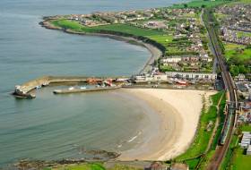
Either way, with an average age of only 30 years compared to the national average of 37, and Ireland’s most rapidly-expanding township population, Balbriggan has become a multi-cultural hotspot of energy and expectations. And there’s no doubt its ancient port – home to a busy little fishing fleet as well as a diverse fleet of recreational craft both power and sail – could be better arranged to become more naturally part of the town with its energetic young people.
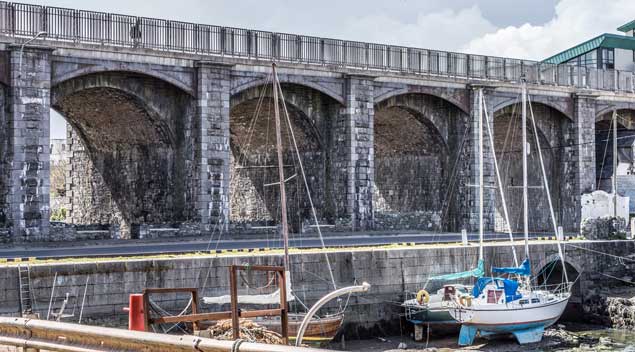 The railway viaduct of 1843-44 added interest and style to the Balbriggan waterfront
However, as local resident Gerry Byrne - who goes afloat with Skerries Sailing Club - has pointed out, we have to remember that Balbriggan is one of Ireland’s oldest artificial harbours, in which you can see its original shape from the Georgian era.
In other words, the basic Balbriggan Harbour which we see today is largely unchanged from the harbour as it was completed pre-1830, the most notable addition since being the construction (in 1843-44) of the handsome railway viaduct which crosses the steep valley where the River Bracken enters the sea at the head of the harbour.
Old it may be, but there’s no denying that Balbriggan Harbour is, how shall we say? – decidedly compact. It’s part of local folklore that, back around 1800, a parliamentary grant was made available to build one really good harbour in the region. But the powerful landlords in Skerries and Balbriggan couldn’t agree on its location, so in the end the money was split in two, and half of it provided a mostly drying pier in Skerries, while the other half provided this little harbour at Balbriggan which is totally drying.
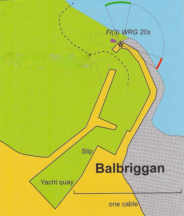 The basic outline of the harbour shows how the need to provide breakwater shelter from southeasterlies may cause silting by sand being carried from the north on the ebb
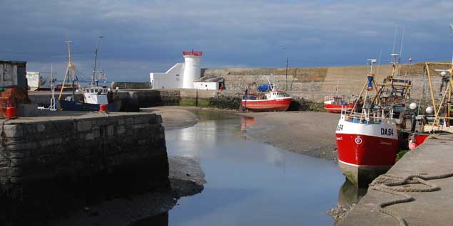
Balbriggan entrance at low water – since this photo was taken, a reproduction of the original light structure has been reinstated on the top of the lighthouse
It’s built in such a way to provide shelter from onshore winds – particularly the southeasters - that any sand which isn’t carried into the harbour by its shape relative to the beach to the north is supplemented by silt being brought down the river, resulting in the inner basin of the harbour providing some of the snuggest mud-berths in Ireland.
A true Balbriggan sailor will think that this is exactly how a harbour should be. Others may think otherwise. Yet you’d be pleasantly surprised how many boat-owners from other ports in the area think that their season isn’t complete without at least one proper visit to Balbriggan when there’s a convenient high water in the early afternoon, because like all Ireland’s port towns large and small, Balbriggan somehow seems much more exotic when you arrive by sea.
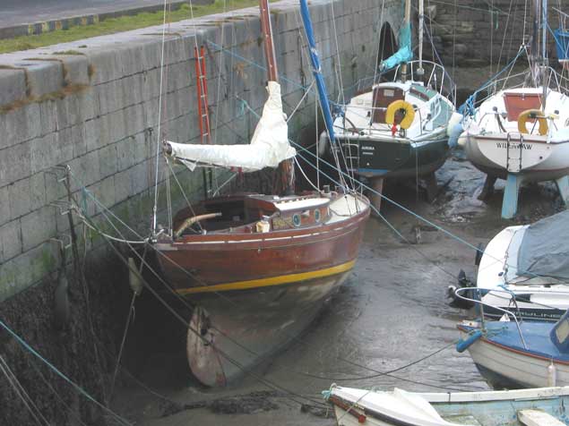 Berthed in Balbriggan. If you’re accustomed to drying out alongside, Balbriggan is one of the snuggest harbours on the East Coast. Photo: W M Nixon
But for those living in the place, the harbour and its nearby town area was beginning to have a tired look, so a Community Group was established early this year under the chairmanship of Dublin City University President Dr Brian McGraith with the support of Fingal County Council to look at the challenge of revitalizing town centre and harbour together.
They’ve moved with commendable speed to come up with proposals and costings which will make town and harbour more accessible to each other while providing a welcoming and entertaining experience for locals and visitors alike.
If the €20 million project is seen through to completion in its various phases (which include a greenway to Skerries), as Professor McGraith puts it: “In a few years, the centre of the town will have been transformed into a restful and attractive place, with public amenities flowing from the River Bracken and the Mill Pond Park through Quay Street down to a completely re-imagined harbour”.
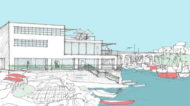 “A completely re-imagined harbour” – Balbriggan as it could be three years hence
Balbriggan to Host Maritime Artefacts Exhibition

#MARITIME EXHIBITION – The Loughshinny & Rush Historical Society is to host a maritime exhibition of artefacts next Thursday (9th February) at the Bracken Court Hotel, Balbriggan, Co. Dublin.
Many items trawled in the locality of the fishing harbour will be displayed to draw attention to the maritime heritage of the area with a view to assessing interest in a local maritime museum.
School trips have been organised during the day and the exhibition will remain open until 21.00.
For further information contact John Daly Tel: 8105059 or Mob: 086 2603738


 as lead helm, rounds the Fastnet Rock on the way to the overall win in 1987")

