Displaying items by tag: Donegal Bay
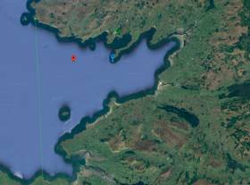
Irish Coast Guard Maritime Exercise in Donegal Bay
The Irish Coast Guard is leading a “large-scale maritime exercise” off the Donegal coast today (Wednesday).
The exercise, called “Blue Hills”, will test major incident plans, it says.
It will also focus on the operational capability and co-ordination of the relevant authorities for a major maritime search and rescue incident, the Irish Coast Guard says.
Agencies involved will include Donegal County Council, the Health Service Executive, Garda Síochána, Dublin Fire Brigade, Naval Service, Air Corps, RNLI and others.
The exercise will be conducted in the proximity of Donegal Bay and include both live and virtual participation, it says.
“There will be no disruption to services during this exercise,” it says.
A planned exercise to test drift and tidal modelling software in Galway Bay on Tuesday was deferred due to a resources issue.
The exercise, which aims to simulate an overdue paddleboarder and swimmer, has been rescheduled to a later date.
Marine Notice: Remedial Works At Bundoran Outfall
#MarineNotice - Marine Notice No 14 of 2018 advises that as part of the Donegal Group B Sewerage Scheme, remedial works are being carried out this week by Norfolk Marine at the Bundoran outfall in Donegal Bay.
These works were scheduled to begin on Tuesday 3 April to last for around one week at 54° 28.778’ N and 08° 19.304’ W, conducted from the vessel Chateau Thierry (Callsign EI-HK-6). An additional small boat or RIB will also be involved in the operation as required.
The work vessel will display appropriate lights and markers, and will monitor VHF Channel 16 throughout the project.
#MarineNotice - TechWorks Marine are deploying three trawl-resistant bottom mounted acoustic Doppler current profiler (ADCP) frames at three locations in Donegal Bay from this week.
The frames, which will be on the sea floor between now and June, are being deployed as part of the oceanographic monitoring programme for the Department of Agriculture, Food and the Marine.
Scheduled for deployment earlier this week on Monday 27 March, the frames will be left in the water for a minimum of one month before being retrieved.
The vessel Dulra na Mara (Callsign EIFS6) will be used for both deployment and collection of the frames. The vessel will be listening on VHF Channel 16 throughout the project.
The frames are 2m by 1m and will remain on the seafloor for a period of up to 90 days, after which each frame will be retrieved by the acoustic release of a pop-up buoy allowing for its recovery.
There will be no surface marker during the extent of deployment so vessel traffic will not need to avoid the area but should be aware of its presence.
A map and co-ordinates of the frame placement points are included in Marine Notice No 14 of 2017, a PDF of which is available to read or download HERE.
Marine Notice: New Hydrographic Survey In Donegal Bay
#MarineNotice - INFOMAR will undertake a hydrographic and geophysical survey in Donegal Bay next weekend 24-25 May.
The RV Celtic Voyager (Call sign EIQN) is expected to carry out the survey operations, which follow up on a previous survey completed last month.
Though the vessel will not be towing any instruments during this survey, she will have limited limited manoeuvrability due to survey line constraints.
The vessel will display appropriate lights and markers, and will be listening on VHF Channel 16 throughout the project.
Details of the survey area are included in Marine Notice No 31 of 2014, a PDF of which is available to read or download HERE.
Marine Notice: Hydrographic Survey In Donegal Bay
#MarineNotice - Marine Notice No 24 of 2014 advises that a hydrographic and geophysical survey operation will be carried out in Donegal Bay between 28 March and 3 April 2014 as part of the INFOMAR programme.
The RV Celtic Voyager (Call sign EIQN) is expected to carry out survey operations in an area bounded by the following co-ordinates:
NE Corner - Lat: 54° 37.545’N; Long: 08° 11.510’W
SW Corner - Lat: 54° 19.718’N; Long: 09° 29.418’W
NW Corner - Lat: 54° 41.909’N; Long: 09° 28.698’W
SE Corner - Lat: 54° 17.165’N; Long: 08° 50.486’W
The vessel will display appropriate lights and markers. The vessel will not be towing any instruments during this survey but will have limited manoeuvrability due to survey line constraints. The vessel will be listening on VHF Channel 16 throughout the project.
All mariners are reminded of their responsibilities under the International Collision Regulations and are reminded of Marine Notice No 17 of 2007, which gives general advice in relation to the activities of vessels engaged in survey work for hydrographic, seismic, fishing research and underwater operations.
The International Regulations for Prevention of Collisions at Sea (COLREGS) are implemented in Irish law by the Merchant Shipping (Collision Regulations) (Ships and Water Craft on the Water) Order 2012 [SI No 507 of 2012], and the Signals of Distress (Ships) Rules 2012 [SI No 170 of 2012]. These Statutory Instruments may be purchased by mail order from Government Publications, Office of Public Works, 52 St Stephen’s Green, Dublin 2 at 01 647 6834/1890 213 434 and are also available online at www.irishstatutebook.ie.
Surfers Swarm on Sligo for Year's Biggest Waves
#SURFING - The Irish Times reports that surfers from around the world are flocking to Sligo in expectation of what might be Ireland's biggest waves of the year.
Breakers of up to 30 feet off Donegal Bay could be the result if growing swells in the Atlantic combine with southerly winds expected from this weekend.
“We have had 50ft waves in the past but 30ft waves would certainly be great and you would have a lot of surfers coming into Ireland to follow them," said top Irish surf pro Richie Fitzgerald.
Elsewhere, President Michael D Higgins made a recent visit to the Somo Surf Centre in Cantabria, northern Spain while attending Spanish courses ahead of his State visit to South America last month, as Oceanlook reports.
“I had already heard of the charms of Loredo and Somo," the President commented. "There are many Irishmen flying to Cantabria in search of sun and also waves to get the chance to surf.”
Cornish Surfer Rides Ireland's Record Biggest Wave
#SURFING - British surfer Jayce Robinson wasn't about to let the largest wave ever recorded off Ireland's shores go by without giving it a shot.
And as Sky News Online reports, he was captured doing exactly that on Tuesday afternoon.
The Cornish surfing pro told the website: "It was definitely the biggest barrell I've ever surfed.
"I was a little nervous but I didn't have time to think about it - it's almost like a car crash, you don't know what's happening."
Robinson rode the giant wave for 20 seconds before the lip crashed down and knocked him off his board.
His surfing partner Lyndon Wake, who towed him to the swell at Mullaghmore Head, said: "It's always a worst case scenario when your tow partner wipes out. Lucky he managed to come out the other side OK."
As previously reported on Afloat.ie, storm force winds off the coast of Donegal produced monster rollers of over 20 metres (over 60 feet) in height detected in Donegal Bay.
Mullaghmore Head will once again welcome the world's top big wave surfers for the second annual Tow-In Surf Session in the New Year.
Hurricane Katia Set to Hit Ireland
"Phenomenal" ocean conditions will be of grave concern to vessels in Irish waters from tomorrow evening as Hurricane Katia makes its approach to Ireland.
As the Irish Independent reports, Met Éireann has considered issuing a severe weater warning today, predicting winds of up to 160kmph and sea flooding on the west coast from Donegal Bay to the Shannon estuary.
On the east coast, winds are expected to reach 130kmph in Dublin on Monday, raising the threat of falling trees and "excessive damage" to property.
The UK Met Office has already taken the rare step of issuing an extreme weather alert for the whole of Ireland.
The category one hurricane is carrying winds of up to 145kmph as it crosses the Atlantic, and is expected to make landfall on the northern half of Ireland tomorrow night.
The Irish Independent has more on the story HERE.
Bottlenose Dolphins Make New Home in Donegal
The Irish Independent reports that some 100 bottlenose dolphins have made a new home off the Donegal coast in the past week.
The pod of bottlenoses - a rare treat in Irish waters compared to the near ubiquitous common dolphin - has been spoted by boaters and wildlife enthusiasts in the inner Donegal Bay, between Rossnowlagh Beach and Doorin Head.
Patrick Lane of the Irish Whale and Dolphin Group said the bottlenose often swims closer to the shore than its more common counterparts, making it much easier for people on shore to catch a glimpse.
The Irish Independent has more on the story, including photos, HERE.
Basking Sharks Pay Early Visit to Ireland's Waters
The recent warm weather has attracted scores of basking sharks to feed in Irish waters weeks ahead of schedule, Metro reports.
Video posted on YouTube by mackerel fishermen in Donegal Bay shows one of the sharks - the second largest species in the big fish family - just metres from their boat:
"We saw about 20 basking sharks that day," fisherman Brian Smith told Metro. "I have never seen so many at this time of year. You don't usually see them until later in May time."
Despite their fearsome size, basking sharks are among the friendlies of Ireland's marine wildlife.
They feed only on plankton and tiny fish - sifting them through their enormous gaping jaws - and are known for their calm temperament.


