Menu

Ireland's sailing, boating & maritime magazine

Displaying items by tag: Drilling Rig Ship

A drilling-rig ship operated by a Swiss-based offshore geo technical data solutions company is currently berthed in Dun Laoghaire Harbour, writes Jehan Ashmore.

According to Dun Laoghaire-Rathdown County Council, the drilling-rig ship Geoquip Saentis is in the harbour to mobilise for work on the Oriel Wind Farm project to the east of Dundalk Bay. The vessel is expected remain in port until tomorrow or Friday.

The 3,404 gross tonnage drill-ship run by Geoquip Marine Operations AG based in St. Gallen, in north-east Switzerland near Liechtenstein, specialises in diverse market segments among them Offshore Renewables, Oil & Gas and Mineral Extraction.

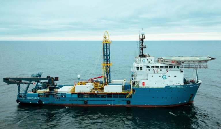
The Swiss shipping firm has a fleet of offshore geotechnical drilling rigs. As for Geoquip Saentis, this drilling rig ship has a Dynamic Positioning (DP2) system for navigational on-site high precision accuracy. In addition, the Multi-Purpose Offshore Support vessel has an on board soil laboratory where data is analysed for clients of projects that can be nearshore (as in project in Dundalk Bay) to waters of ultra-deep oceans.

Afloat tracked the Geoquip Saentic which sailed from Nigg on the Gromarty Forth in north-east Scotland. Also offshore of Aberdeen, the ship in October completed its first geotechnical site investigation in the North Sea involving drilling to over 2000 metres.

The arrival of Geoquip Saentis to the Irish Sea involved a transit through the North Channel. After anchoring in Dublin Bay yesterday, a pilot was transferred on board from Dublin Port Company's new cutter DPC Tolka as previously reported.

drill ship
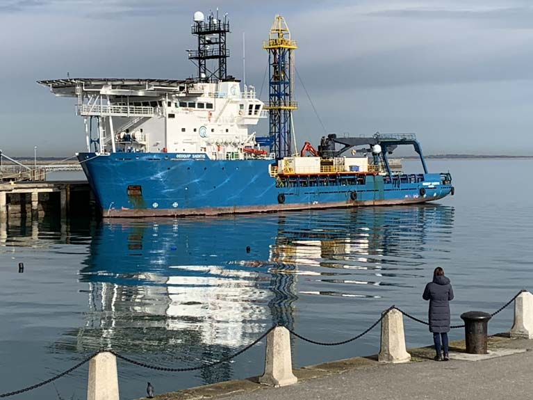
Geoquip Saentis along side in Dun Laoghaire Photo: Afloat

In observing the design of Geoquip Saentis, Afloat concluded the vessel was a former platform supply vessel (PSV) which has been identified as the former Toisa Viligant. The vessel built in 2005 was specially designed to supply offshore oil and gas platforms. Following the acquisition by Geoquip Marine which coincidentally took place on this date exactly a year ago, the ship received conversion overhaul works to enable offshore geotechnical operations.

The major overhaul of Geoquip Saentis took place in the UK at Cammell Laird, the shipyard on Merseyside (see yesterday's Afloat coverage) of the Royal Fleet Auxiliary's tanker RFA Fort Victoria.

The drilling ship was dry-docked at the facility in Birkenhead on the Wirral Peninsula, which included notably the installation of Geoquip’s GMR600 marine drill-rig situated amidships as demonstrated in the above photo. Underneath the rig is a 4m x 4m moon pool. 

Geoquip Saentis has accommodation and workspaces for 55 crew members. At 80m in length and an 18m beam, this provides a stable platform for offshore geotechnical operations which includes use of a Remotely Operated Vessel (ROV) to operate alongside the drill-rig.

Marine Protected Areas (MPAs) - FAQS

Marine protected areas (MPAs) are geographically defined maritime areas where human activities are managed to protect important natural or cultural resources. In addition to conserving marine species and habitats, MPAs can support maritime economic activity and reduce the effects of climate change and ocean acidification.

MPAs can be found across a range of marine habitats, from the open ocean to coastal areas, intertidal zones, bays and estuaries. Marine protected areas are defined areas where human activities are managed to protect important natural or cultural resources.

The world's first MPA is said to have been the Fort Jefferson National Monument in Florida, North America, which covered 18,850 hectares of sea and 35 hectares of coastal land. This location was designated in 1935, but the main drive for MPAs came much later. The current global movement can be traced to the first World Congress on National Parks in 1962, and initiation in 1976 of a process to deliver exclusive rights to sovereign states over waters up to 200 nautical miles out then began to provide new focus

The Rio ‘Earth Summit’ on climate change in 1992 saw a global MPA area target of 10% by the 2010 deadline. When this was not met, an “Aichi target 11” was set requiring 10% coverage by 2020. There has been repeated efforts since then to tighten up MPA requirements.

Marae Moana is a multiple-use marine protected area created on July 13th 2017 by the government of the Cook islands in the south Pacific, north- east of New Zealand. The area extends across over 1.9 million square kilometres. However, In September 2019, Jacqueline Evans, a prominent marine biologist and Goldman environmental award winner who was openly critical of the government's plans for seabed mining, was replaced as director of the park by the Cook Islands prime minister’s office. The move attracted local media criticism, as Evans was responsible for developing the Marae Moana policy and the Marae Moana Act, She had worked on raising funding for the park, expanding policy and regulations and developing a plan that designates permitted areas for industrial activities.

Criteria for identifying and selecting MPAs depends on the overall objective or direction of the programme identified by the coastal state. For example, if the objective is to safeguard ecological habitats, the criteria will emphasise habitat diversity and the unique nature of the particular area.

Permanence of MPAs can vary internationally. Some are established under legislative action or under a different regulatory mechanism to exist permanently into the future. Others are intended to last only a few months or years.

Yes, Ireland has MPA cover in about 2.13 per cent of our waters. Although much of Ireland’s marine environment is regarded as in “generally good condition”, according to an expert group report for Government published in January 2021, it says that biodiversity loss and ecosystem degradation are of “wide concern due to increasing pressures such as overexploitation, habitat loss, pollution, and climate change”.

The Government has set a target of 30 per cent MPA coverage by 2030, and moves are already being made in that direction. However, environmentalists are dubious, pointing out that a previous target of ten per cent by 2020 was not met.

Conservation and sustainable management of the marine environment has been mandated by a number of international agreements and legal obligations, as an expert group report to government has pointed out. There are specific requirements for area-based protection in the EU Marine Strategy Framework Directive (MSFD), the OSPAR Convention, the UN Convention on Biological Diversity and the UN Sustainable Development Goals. 

Yes, the Marine Strategy Framework directive (2008/56/EC) required member states to put measures in place to achieve or maintain good environmental status in their waters by 2020. Under the directive a coherent and representative network of MPAs had to be created by 2016.

Ireland was about halfway up the EU table in designating protected areas under existing habitats and bird directives in a comparison published by the European Commission in 2009. However, the Fair Seas campaign, an environmental coalition formed in 2022, points out that Ireland is “lagging behind “ even our closest neighbours, such as Scotland which has 37 per cent. The Fair Seas campaign wants at least 10 per cent of Irish waters to be designated as “fully protected” by 2025, and “at least” 30 per cent by 2030.

Nearly a quarter of Britain’s territorial waters are covered by MPAs, set up to protect vital ecosystems and species. However, a conservation NGO, Oceana, said that analysis of fishing vessel tracking data published in The Guardian in October 2020 found that more than 97% of British MPAs created to safeguard ocean habitats, are being dredged and bottom trawled. 

There’s the rub. Currently, there is no definition of an MPA in Irish law, and environment protections under the Wildlife Acts only apply to the foreshore.

Current protection in marine areas beyond 12 nautical miles is limited to measures taken under the EU Birds and Habitats Directives or the OSPAR Convention. This means that habitats and species that are not listed in the EU Directives, but which may be locally, nationally or internationally important, cannot currently be afforded the necessary protection

Yes. In late March 2022, Minister for Housing Darragh O’Brien said that the Government had begun developing “stand-alone legislation” to enable identification, designation and management of MPAs to meet Ireland’s national and international commitments.

Yes. Environmental groups are not happy, as they have pointed out that legislation on marine planning took precedence over legislation on MPAs, due to the push to develop offshore renewable energy.

No, but some activities may be banned or restricted. Extraction is the main activity affected as in oil and gas activities; mining; dumping; and bottom trawling

The Government’s expert group report noted that MPA designations are likely to have the greatest influence on the “capture fisheries, marine tourism and aquaculture sectors”. It said research suggests that the net impacts on fisheries could ultimately be either positive or negative and will depend on the type of fishery involved and a wide array of other factors.

The same report noted that marine tourism and recreation sector can substantially benefit from MPA designation. However, it said that the “magnitude of the benefits” will depend to a large extent on the location of the MPA sites within the network and the management measures put in place.

© Afloat 2022