


Displaying items by tag: Great South Wall
Hopes for Concrete Blocks With Imprint of Ringaskiddy Shoreline to Boost Biodiversity in Dublin Bay
Dublin’s Great South Wall has taken on the appearance of the Cork Harbour shoreline thanks to a new biodiversity project.
According to RTÉ News, a series of large concrete blocks imprinted with a mould of the Ringaskiddy coastline have been placed at the foot of the wall — providing a rougher topography that is hoped will be a safe haven for marine micro-organisms to thrive.
Researchers at UCD who developed the scheme chose the nooks and crannies on the water’s edge at Ringaskiddy above more than 60 other shorelines, both naturally rocky and human-made, as the model for their project in collaboration with the Dublin Port Company.
And if the Dublin Bay experiment is successful, then Ringaskiddy’s topography could be replicated on sea walls, piers and other structures around the country.
RTÉ News has more on the story HERE.
Dublin Port Company has created a splash of colour for the Dublin Pride Festival this week with a new mural installation at the Great South Wall, which attracts over 500 walkers daily.
The Dublin LGBTQ+ Pride Festival 2022 runs until next Tuesday 28 June. However, the whole of June is considered Pride Month with a host of organisations and venues running Pride events across the city and county.
The Dublin Pride Parade and March will take place this Saturday 25 June with over 13,000 people registered to take part and the route runs from O’Connell Street to Merrion Square.
 The iconic diving bell on Sir John Rogerson’s Quay will be lit up in rotating Pride colours each evening for the duration of the festival | Credit: Conor McCabe Photography
As part of Dublin Pride 2022, Dublin Port Company has created a new ‘Pride at the Port‘ mural at the Great South Wall which incorporates the pride colours as a symbol of solidarity with our LGBTQ+ community.
Pride flags will fly high throughout Dublin Port and the iconic diving bell on Sir John Rogerson’s Quay will be lit up in the rolling colours of the rainbow each evening at dusk for the duration of the festival.
The Great South Wall walk to Poolbeg Lighthouse is a very popular tourist attraction taking in great views of Dublin Bay, with over 180,000 visitors passing the ‘Half Moon’ swimming club over the 12 month period March 2021 to March 2022, the port states.
Wind Forecast Prompts Temporary Closure for Great South Wall
Dublin Port Company has announced a temporary closure of pedestrian access to the Great South Wall Due to forecasted high winds and tides in Dublin Bay from tonight, Monday 22 February.
Access will be closed from tonight at 10pm until Wednesday morning, 24 February, at 4am. There is no requirement to close Bull Island Bridge at this time.
The port company says the Great South Wall closure is due to tide height and dangerous winds on the exposed wall surface.
Delays to some shipping activity and pilotage services are also likely, including possible delays at the port’s LOLO container terminals.
Dublin Port Company says it will continue to monitor the situation and provide relevant updates via social media channels and on dublinport.ie
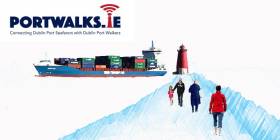
#PortWalks - Download, walk & listen with the Dublin Port Walks this May Bank Holiday Monday where there is an opportunity to engage with your surroundings on a walk and through a free site specific public artwork. Port Walks is an online audio project connecting Dublin Port Seafarers with Dublin Port Walkers.
On 1st May (10.30-11.30 am) at the Sluice House on the Great South Wall, artist Sheelagh Broderick is holding a public meet up with walkers for a "work in progress" review.
Registered walkers will be invited to download the first of several project podcasts and to listen to it while taking a walk on the Great South Wall. The first podcast addresses the radical reconfiguration of contemporary shipping and seafaring in the last 50 years. Sheelagh will be on hand to answer questions before and afterwards.
The podcast is available for download on portwalks.ie/podcasts as well as other platform providers (iTunes /SoundCloud). Walkers should download content prior to arrival. In the event that anyone has a difficulty with downloads, please come a little earlier than the advertised time for assistance.
Please Register (noting limited numbers) for an available time slot by clicking this link.
Old Maps Show A Very Different Dublin Bay Before The Walls

#DublinBay - Dublin Bay was we know it today looked very different three centuries ago, as TheJournal.ie highlights with a selection of enlightening historical maps.
As reported yesterday on Afloat.ie, this week marks the 300th anniversary of the decision to build the Great South Wall in an effort to solve the centuries-old problem of silting in the main channels to Dublin Port.
At that time, the area north of Townsend Street that today is the south Docklands did not exist, as the Liffey flowed right up to what was then called Lazar's Hill or Lazy Hill – while Ringsend was a sandpit that extended into the bay at the river's mouth.
The wall changed all that, as the land between was reclaimed and the Liffey's course straightened and strengthened over the 80 years of its construction.
Later change came to the Northside, too, with the construction of the Bull Wall – surveyed by Captain Bligh of 'Mutiny on the Bounty' infamy – as Marino, Fairview and the North Strand, so named for their then coastal locations, lost their sea views to land reclamation, and Bull Island was formed from the sand and silt that once claimed any number of ships on approach to the city.
The maps have been shared by the Dublin Port Company to coincide with the Dublin Bay Conference that takes place today (Wednesday 29 April) with a programme of lectures lined up to celebrate the construction of what was then the longest sea wall in the world.
The Great South Wall: 300 Years Since Idea First Hatched
#DublinPort - Three hundred years ago this week, the decision was made by the Dublin City Assembly to build an embankment from Ringsend into Dublin Bay, in an effort to solve the centuries-old problem of silting in the main channels into Dublin Port.
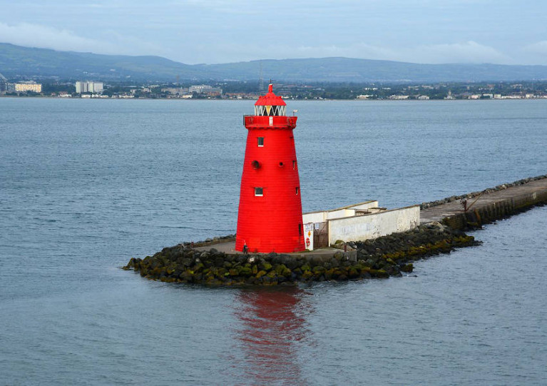
As RTÉ reports, Philip Bromwell has commemorated this historic occasion with a special multimedia report on the engineering feat, which today extends some 4km to the Poolbeg Lighthouse.
When completed 80 years after plans were first announced, the Great South Wall was the longest sea wall in the world.
And it's still a vital part of the city's infrastructure, helping – along with its sister Bull Wall on the north side of the bay – to keep the port's waters clear of silt and sand build-up for shipping traffic.
But it's also a popular recreation spot for walkers, cyclists, anglers and anyone looking to take in the spectacular vistas of the bay in the shadow of the iconic Poolbeg chimneys.
Get the whole story on the Great South Wall's 300th anniversary HERE.


 as lead helm, rounds the Fastnet Rock on the way to the overall win in 1987")

