Displaying items by tag: Irish Navigating Round Ireland
Navigating Round Ireland Tips
Plotting for going round – part I
The well-organised navigator will already have a game plan for the BMW Round Ireland Race. Course veteran Brian Mathews shares some of the secrets of this 704-mile classic

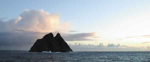
A mark on the course – the Skelligs rock off the Kerry coast is a turning point Photo: David Branigan
First steps first is the answer to sound preparation for the Round Ireland. All homework should be completed no less than two weeks ahead of the start – a stress-free approach is the hallmark of good navigation. We’ll assume for this article that the safety side of preparations is being taken care of by the skipper. Remember that survival, first aid, previous experience and other race and ORC requirements cannot be overlooked.
Basic navigation strategy follows standard practice and a good passage plan will save you from endless grief during the race. My own preference is for IMRAY charts as they fit small yachts better than Admiralty editions, are water-resistant and are latticed with Lat/Long for faster plotting. While you can correct existing charts, it’s better not to try to save the few euro that a new edition will cost.
Plot your rhumb-line course for the race, taking care to note the organiser’s stipulations on navigation. It’s not simply a case of leaving Ireland and its islands to starboard – it’s too easy to get caught out by marks on the course such as the Conningbeg and the Fastnet.
As with any passage plan, note the waypoints and the Lat/Long for each leg with the course and distance in sequence. Again in sequence, add Pilotage notes to each stage as well as transferring the complete plan to a ‘Wet Notes’ pad.
By race day, the passage plan should be finalised and committed both to paper and to memory too, if possible. Attending the official briefing with the skipper is both mandatory and essential. Expect considerable emphasis on the reporting requirements as well as the usual amendments to sailing instructions. The 72-hour forecast from Met Eireann will also be available – the fax version is preferred.
Be at the start line no later than one hour beforehand and motor to Wicklow Head to check the true wind as there’s often a different breeze off the harbour. Back to the starting line and it’s time to brief the crew on your plan and what to expect – avoid excessive detail. Having a keen picture of your plan in your mind will avoid the need for constant trips to the chart table – hatch rat navigators are bad for morale. From the gun and for the opening stage of the race, aim to sail inside the Arklow Bank, irrespective of the wind direction as the tide will be flooding this year. This should mean arriving at the Blackwater Bank with the young ebb and from here heading outside the banks to the Tuskar.
This ebb should get most of the fleet around the Tuskar Rock, one of the major tidal gates in the race, but it’s possible that some of the smaller boats won’t make it in time. If it does look like you’ll luck out on a foul tide, plan to be inshore so that you can kedge if necessary. If you have to anchor, remember your light by night and shape in daylight – the IRPCS apply to all vessels at sea, at all times.
Right about now, your homework will pay off as Rosslare is a busy ferry port and sailing times can be found on the web. Expect traffic off Dunmore East at the Waterford Estuary on the high tide and at Cork too.
By the Tuskar rounding, it will be dusk or darkness for the majority of the fleet. A reducing distance/time/ boatspeed matrix for the first stage from the start to the Tuskar Rock (approx 49nm) will enable you to plan the watch system for the crew.
The loom of the Conningbeg 20 miles away should be visible and coming abeam of it will mark your first chance to grab some rest. Navigation tactics for the south coast boil down to wind direction: following breeze equals a rhumb-line course while headwinds demand tacking for the shore, across the chop but on the paying tack as much as possible. If the former, warn the helm of the danger of straying from the course – this next leg from the Conningbeg to the Old Head of Kinsale is 75 miles, so even a five-degree error can be costly.
In previous races, we have even noticed magnetic anomalies during rain and electrical activity in this area so – be vigilant, keeping in mind that B&G systems also work off a magnetic and fluxgate system.
The silhouette of the Saltees, inshore of the Conningbeg Light followed by Hook Head, Mine Head and Ballycotton lights are useful references on the course past Roche’s Point, hopefully by dawn. Salmon nets are a significant hazard from Mine Head onwards and you shouldn’t need to be inshore before this.
The tide on the south coast is relatively light but the percentage gain improves as the wind goes light. Often a visual tide-line can be observed between headlands so plan to sail in the bays during the flood.
The stage from the Old Head to the Fastnet is a 42-mile leg and another rhumb-line course unless headwinds force you to tack inshore. Major hazards here include The Stags between Glandore and Baltimore and the wreck of the Kowloon Bridge that is buoyed.
COPYRIGHT AFLOAT 2004
Make or break – part II
Round Ireland veteran Brian Mathews concludes his guide to navigating the 704-mile classic with advice on the stages that will decide how – and if – you finish

The Kish Lighthouse marking the entrance to Dublin Bay is the final waypoint before the finish and the rhumb runs straight down the centre of the bank. If the tide is foul here, sail inshore. Otherwise take the ebb south to the finish. Our picture shows Frank Clarke’s Sapphire, well up on corrected time, passing outside the lighthouse in the last hours of the 2002 race. Photo: David O’Brien
In the last issue of Afloat, we concentrated on the importance of proper preparation and a carefully considered passage plan. Our first stage of the race has taken us to the Fastnet Rock and this usually marks the point where those with the ability to last the course begin to separate from those without it.
From the Fastnet, a series of headlands mark the entrances to the large bays of the south-west coast – the Mizen, Bull Rocks, Skelligs and Innistearacht are all clearing marks on the course and should hopefully be rhumb line sailing past each. If beating around this stage, tack into the bays for a lift off the headlands coming out, as well as taking the benefit of calmer waters inshore. Above all, strictly no flyers out to sea around here!
In your passage notes, don't forget the various isolated rocks on this stage such as the Bull Rock with its attendant Cow and Calf rocks too. Check the charts carefully and remember, these are unlit hazards.
Turning onto the west coast from Innistearacht is usually a relief and a major psychological boost for the crew. Up until now, the race has been an investment of pain – now it’s time for gain. At last the open waters of the Atlantic and their long swells stand to offer the best boatspeed potential. This is also the first time you're likely to lose sight of land after leaving the Kerry coastline until your landfall off Connemara with its back-drop of the Twelve-Bens mountains.
Ports of refuge should also be part of your planning – there is a range of options after the West Cork coast and not all will suit in every condition. Castletownberehaven must be approached from the east in strong gales whilst Smerwick Harbour after Innistearacht is a natural anchorage except in north-west gales. The marinas at Dingle, Cahirciveen and Fenit are very welcome recent developments; Kilrush Marina on the Shannon Estuary is some way off the course but is another option. After here, the leeside of Aran Mor breaks the gap between Kerry and the next shelter at Broadhaven Bay near Belmullet.
Nevertheless, previous races would suggest that if you've made it this far, the trigger has been pulled and, barring serious damage or injury, you'll be determined to reach the finish.
From the north-west coast onwards, different strategies will evolve as the fleet will have become spread out and the leaders are likely to be experiencing completely different conditions than the back-markers.
Typically, the first boats could be at Eagle Island while the last boats are still on the south-west coast. But the race decider has yet to come into play.
On reaching the north coast, tide once again becomes a factor and a substantial one at that. This is the ‘Salmon Highway’ and nets up to three miles long will be everywhere at this time of year. These will normally be well-tended and best advice seems to be that if the attendant fishing boat is underway at speed, she will be shooting her nets so it should be obvious where they are. If stationary, sail for the fishing boat as it will normally mark the end of the net – monitor the radio as you are likely to receive instructions on the best way to avoid a fouling. Should this happen, a long pole with a split end can be used to push the net down below the keel and clear astern without cutting or damaging the gear.
Entering the North Channel between the Ulster coast and Scotland will see the strongest tides of the entire race. Bear in mind that the tide floods south in the stretch before reversing in the north Irish Sea. Three major tidal gates form close to Tory, Rathlin and the Maidens. The best advice in a foul tide seems to be to sail inshore and go for mid-channel with the flood. Plan ahead for where you want to be when the tide changes next. Also be prepared to kedge if the breeze dies along this leg.
The Antrim plateau often causes wind-sheer so be prepared for constant changes of wind direction. Conversely, the Mournes create shadow so Dundrum Bay on the north-east coast should be avoided at all costs. The tide is neutral in here but don't be lured by its apparent attractiveness.
From here on is where the race will be won or lost. Most likely it will be the last night at sea but don't suspend the watch system because of this – anything can yet happen and even though the finish will be in sight, the wind can and does die. The Kish Lighthouse marks the final waypoint before the finish and the rhumb runs straight down the centre of the bank. If the tide is foul here, sail inshore. Otherwise take the ebb south to the finish.
Key points to remember:
• The tidal atlas will be your bible
• Prepare a detailed passage plan
• Keep a balanced watch system
• Swing your compass and keep a deviation card handy
• Rigidly observe the race rules for radio check-in points
• Complete your safety preparations and gear checks in full
COPYRIGHT AFLOAT 2004
Please note: These tips are intended as a guide only. Views expressed are not necessarily those of the publisher.
More on the Round Ireland Yacht Race:
Round Ireland Yacht Race 2010 Review
Round Ireland Yacht Race, Ireland's top offshore fixture
A Round up of 80 stories on the 2010 Round Ireland Yacht Race


