Menu

Ireland's sailing, boating & maritime magazine

Displaying items by tag: Islay

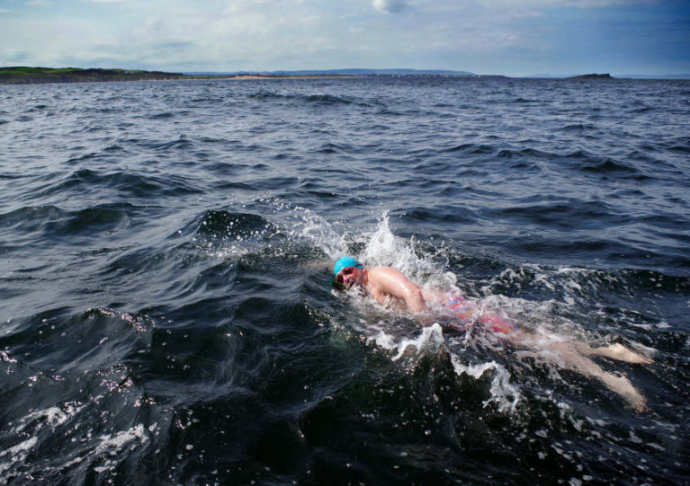
Members of an open sea swimming team have become the first to complete a challenging route between Scotland and the Giant’s Causeway, as the Greenock Telegraph reports.

The Oa Giants set out from Islay last Saturday 8 August and crossed the Oa Channel by relay, reaching Northern Ireland’s North Coast on Sunday 9 August with a final time of 16 hours and 57 minutes.

Comprising Keith Garry, Dominic Mudge, Bill Donnelly, Chris Judge, Colin Lindsay and John McElroy, the team were already record-breakers heading into their challenge.

That was after setting a time of nine hours, two minutes and 41 seconds across the North Channel between the Gobbins and Portpatrick as a practice swim the previous weekend.

And their achievements all the more impressive knowing that the youngest of the group, Chris Judge, is 38 years old.

Judge also told of the “real mental battle” posed by the difficult north-south Oa Channel crossing, not least contending with the potentially lethal stings of lion’s mane jellyfish.

The Greenock Telegraph has more on the story HERE.

Published in Sea Swim

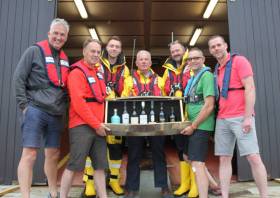
A group of seven men from the North Coast hatched a novel way to carry out some fundraising for the Portrush and Islay RNLI volunteer lifeboat crews recently.

As a group of keen sailors and avid supporters of the RNLI and the Scottish islands, they wanted to marry the two passions together and have some fun along the way.

The team decided to row to Islay to recreate a journey made over the generations using only manpower to raise money for the lifeboats.

The team was fortunate to be able to borrow ‘Home to Portrush’, the famous local boat that had crossed the Atlantic in record time in February 2018. Their challenge was to visit all the coastal distilleries on Islay and collect some whiskey from each one.

Ashley Moore, one of the crew, said: “We left from Ballintoy at 3am in idyllic conditions in order to reach Port Ellen and not be swept around the headland as the tide turned.

“Thankfully we made it in nine-and-a-half hours and over the next three days went on to visit Laphroaig, Lagavulin, Ardbeg, Coal Ila, Bunnahabhain, Bowmore and Bruichladdich, collecting whisky bottles along the way.

“We were blown away by the warmth of the welcome across Islay and the distilleries — we were given many offers of food and accommodation and each distillery presented us with a bottle of whisky and a stave from one of their barrels to allow us to create the Islay Sea Collection.”

On returning home, team member and local architect Graeme Montgomery set out to design and create a unique cask to display the bottles of whisky, with the source of each stave marked.

‘This is a really exciting and novel way to raise funds for the two stations’

Bids are now being accepted until Sunday 17 November at just-whisky.co.uk for this ‘one of a kind’ whisky collection — and sponsors, including Coleraine software company Spatialest, have already pledged £2,000.

To register to bid you will have to pay £5 but this will be donated to RNLI. During registration, under box number 2 will see a box asking you to leave a message — in this box you must type in RNLI BID to ensure that the £5 registration fee comes to Portrush and Islay RNLI.

Portrush lifeboat operations manager Keith Gilmore said: “This is a really exciting and novel way to raise funds for the two stations. We often have to work with Islay, and this is a great way to work with one of our neighbours and local supporters to raise funds for the RNLI.”

Ashley Moore added: “This was a really fun way to see the Scottish islands in a different way while helping to raise funds to support the work of the RNLI – and to enjoy some exceptional whisky!

“As sea lovers each one of our team never takes for granted the exceptional and brave work of the lifeboat crews and we are so grateful to know they are there whenever needed.”

Published in RNLI Lifeboats

#SURFING - Northern Irish surf pro Al Mennie will be taking on a different challenge later this month, when he sets out to paddle a surfboard from the Giant's Causeway to Scotland in the name of charity.

"It will be the northernmost crossing of its type in the world," says Mennie of the 25-mile route from Antrim to the Scottish island of Islay.

"I will have to deal with freezing cold temperatures, large open ocean swell, potentially high winds and the deadly currents around a well known navigational hazard of a North Atlantic island."

Mennie will be on his own except for a support boat carrying food and water. He will be wearing a 6mm wetsuit and crossing the most dangerous stretch of water around the Irish coastline, "known for its extremely deadly currents as the Irish Sea tides drain between Rathlin Island and Northern Ireland".

The NI surfer is embarking on the challenge in aid of Northern Ireland Chest Heart and Stroke, which is a charity close to his own heart.

"My dad died suddenly of a heart attack aged 50 and I know lots of people who have also lost loved ones to heart problems too," he says, "so I really want to help make a difference by raising money for this charity."

For more details or to make a donation, visit the charity page at Al Mennie's website HERE.

Published in Surfing

Marine Protected Areas (MPAs) - FAQS

Marine protected areas (MPAs) are geographically defined maritime areas where human activities are managed to protect important natural or cultural resources. In addition to conserving marine species and habitats, MPAs can support maritime economic activity and reduce the effects of climate change and ocean acidification.

MPAs can be found across a range of marine habitats, from the open ocean to coastal areas, intertidal zones, bays and estuaries. Marine protected areas are defined areas where human activities are managed to protect important natural or cultural resources.

The world's first MPA is said to have been the Fort Jefferson National Monument in Florida, North America, which covered 18,850 hectares of sea and 35 hectares of coastal land. This location was designated in 1935, but the main drive for MPAs came much later. The current global movement can be traced to the first World Congress on National Parks in 1962, and initiation in 1976 of a process to deliver exclusive rights to sovereign states over waters up to 200 nautical miles out then began to provide new focus

The Rio ‘Earth Summit’ on climate change in 1992 saw a global MPA area target of 10% by the 2010 deadline. When this was not met, an “Aichi target 11” was set requiring 10% coverage by 2020. There has been repeated efforts since then to tighten up MPA requirements.

Marae Moana is a multiple-use marine protected area created on July 13th 2017 by the government of the Cook islands in the south Pacific, north- east of New Zealand. The area extends across over 1.9 million square kilometres. However, In September 2019, Jacqueline Evans, a prominent marine biologist and Goldman environmental award winner who was openly critical of the government's plans for seabed mining, was replaced as director of the park by the Cook Islands prime minister’s office. The move attracted local media criticism, as Evans was responsible for developing the Marae Moana policy and the Marae Moana Act, She had worked on raising funding for the park, expanding policy and regulations and developing a plan that designates permitted areas for industrial activities.

Criteria for identifying and selecting MPAs depends on the overall objective or direction of the programme identified by the coastal state. For example, if the objective is to safeguard ecological habitats, the criteria will emphasise habitat diversity and the unique nature of the particular area.

Permanence of MPAs can vary internationally. Some are established under legislative action or under a different regulatory mechanism to exist permanently into the future. Others are intended to last only a few months or years.

Yes, Ireland has MPA cover in about 2.13 per cent of our waters. Although much of Ireland’s marine environment is regarded as in “generally good condition”, according to an expert group report for Government published in January 2021, it says that biodiversity loss and ecosystem degradation are of “wide concern due to increasing pressures such as overexploitation, habitat loss, pollution, and climate change”.

The Government has set a target of 30 per cent MPA coverage by 2030, and moves are already being made in that direction. However, environmentalists are dubious, pointing out that a previous target of ten per cent by 2020 was not met.

Conservation and sustainable management of the marine environment has been mandated by a number of international agreements and legal obligations, as an expert group report to government has pointed out. There are specific requirements for area-based protection in the EU Marine Strategy Framework Directive (MSFD), the OSPAR Convention, the UN Convention on Biological Diversity and the UN Sustainable Development Goals. 

Yes, the Marine Strategy Framework directive (2008/56/EC) required member states to put measures in place to achieve or maintain good environmental status in their waters by 2020. Under the directive a coherent and representative network of MPAs had to be created by 2016.

Ireland was about halfway up the EU table in designating protected areas under existing habitats and bird directives in a comparison published by the European Commission in 2009. However, the Fair Seas campaign, an environmental coalition formed in 2022, points out that Ireland is “lagging behind “ even our closest neighbours, such as Scotland which has 37 per cent. The Fair Seas campaign wants at least 10 per cent of Irish waters to be designated as “fully protected” by 2025, and “at least” 30 per cent by 2030.

Nearly a quarter of Britain’s territorial waters are covered by MPAs, set up to protect vital ecosystems and species. However, a conservation NGO, Oceana, said that analysis of fishing vessel tracking data published in The Guardian in October 2020 found that more than 97% of British MPAs created to safeguard ocean habitats, are being dredged and bottom trawled. 

There’s the rub. Currently, there is no definition of an MPA in Irish law, and environment protections under the Wildlife Acts only apply to the foreshore.

Current protection in marine areas beyond 12 nautical miles is limited to measures taken under the EU Birds and Habitats Directives or the OSPAR Convention. This means that habitats and species that are not listed in the EU Directives, but which may be locally, nationally or internationally important, cannot currently be afforded the necessary protection

Yes. In late March 2022, Minister for Housing Darragh O’Brien said that the Government had begun developing “stand-alone legislation” to enable identification, designation and management of MPAs to meet Ireland’s national and international commitments.

Yes. Environmental groups are not happy, as they have pointed out that legislation on marine planning took precedence over legislation on MPAs, due to the push to develop offshore renewable energy.

No, but some activities may be banned or restricted. Extraction is the main activity affected as in oil and gas activities; mining; dumping; and bottom trawling

The Government’s expert group report noted that MPA designations are likely to have the greatest influence on the “capture fisheries, marine tourism and aquaculture sectors”. It said research suggests that the net impacts on fisheries could ultimately be either positive or negative and will depend on the type of fishery involved and a wide array of other factors.

The same report noted that marine tourism and recreation sector can substantially benefit from MPA designation. However, it said that the “magnitude of the benefits” will depend to a large extent on the location of the MPA sites within the network and the management measures put in place.

© Afloat 2022