


Displaying items by tag: Lifeboat Station Project

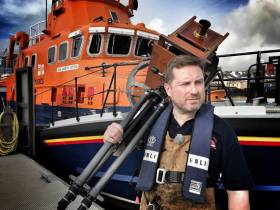
Five years into his remarkable and challenging project to photograph all RNLI lifeboat station in the UK and Ireland with a Victorian-era camera, Jack Lowe has visited 147 stations and met more than 2,000 volunteers.
And it’s not over yet, as the West of Ireland and Scotland’s Western Isles are among those locations yet to be covered by The Lifeboat Station Project between now and the end of 2022.
They will add to the more than 35,000 miles he’s already covered with his trusty converted ambulance, ‘Neena’, which also serves as his mobile darkroom for the 19th-century wet plate collodion process he used to produce his distinct, monochrome images.
Last September, Lowe toured Northern Ireland to complete that 10-station leg of his mammoth undertaking.
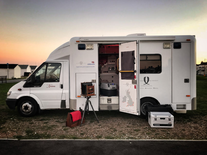 Neena, the converted ambulance Jack Lowe uses as a mobile darkroom | Photo: RNLI
That came almost a year after he reached the half-way mark in his project, shortly following his 100th station visit at Valentia — and at a time of self-doubt, before crowdfunding support provided the boost needed to see the rest of the task through.
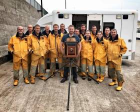
At the same time, he’s expanded the scope of the project — including images of station mechanics and other key volunteers, as well as making sound recordings that go ‘behind the scenes’.
“Ultimately, I’m honoured beyond words to be making this archive,” Lowe says. “It’s a privilege spending time with so many lifeboat volunteers, preserving their bravery and devotion for future generations.”
The Lifeboat Station Project’s dedicated website has links to Lowe’s Facebook, Twitter and Instagram feeds, as well as his Patreon campaign.
Photographer Jack Lowe Tours Northern Ireland In Bid To Capture Every RNLI Lifeboat Station With Victorian Camera
Nearly five years into his epic project to photograph every RNLI lifeboat station with a Victorian-era camera, Jack Lowe this week began the Northern Ireland leg of the mammoth undertaking.
Starting yesterday (Tuesday 3 September) at Red Bay, Lowe’s four-week swing also includes Portrush tomorrow (Thursday 5 September), then Enniskillen, Carrybridge, Newcastle, Kilkeel, Portaferry, Donaghadee, Bangor and Larne before he returns home to Newcastle-upon-Tyne — via Portpatrick and Stranraer in Scotland.
Lowe will capture each lifeboat station and its crew using wet plate collodion, a process developed in the 1850s — when the RNLI also began — that creates stunning images on glass.
Following this 19th leg, the end of The Lifeboat Station Project will be in sight as the remaining station count will be down to double figures.
When completed, The Lifeboat Station Project will be the very first time every station on the RNLI network been documented as one complete body of work. It is also one of the biggest photographic projects ever undertaken, the RNLI says.
As with the rest of his adventure, Lowe travelled to Northern Ireland on Monday (2 September) with ‘Neena’, a decommissioned NHS ambulance purchased on eBay, which he converted into a mobile darkroom.
Along the way Lowe has been sharing the ups and downs of his mission on social media. He also makes videos and sound recordings, enabling his followers to get a real sense of what life is like within lifeboat communities.
Almost a year ago, Lowe reached the halfway mark of his epic project that previously took him to Ireland’s South Coast, where he completed his 100th station in Valentia.
By the end of September 2018, he estimates to have used around 1,500 glass plates, 120 litres of developer and 45 litres of collodion.
Lowe had also driven some 28,000 miles — the equivalent of more than once round the world.
“It’s a privilege spending time with so many lifeboat volunteers, preserving their bravery and devotion for future generations,” Lowe says.
“This journey is unprecedented in so many ways. The further I travel, the deeper the body of work becomes on just about every level and in ways that I could never have foreseen or imagined.”
The Lifeboat Station Project’s dedicated website has links to Lowe’s Facebook, Twitter and Instagram feeds, as well as his Patreon campaign.
Photographer Reaches Halfway Mark On Epic Project To Capture Lifeboat Stations With Victorian Camera
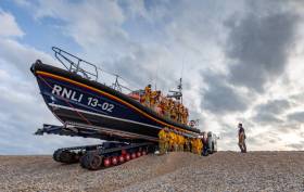
#Lifeboats - After almost four years, Jack Lowe will this week reach the halfway point of his epic ambition to photograph all 238 stations in the RNLI network when he visits Dover Lifeboat Station.
Since he began The Lifeboat Station Project in January 2015, Lowe has photographed more than 2,000 lifeboat volunteers — and around a dozen dogs, who are often included if their owners are on the crew — using wet plate collodion, a Victorian process that creates stunning images on glass.
And he produces his work on the road in ‘Neena’, a decommissioned NHS ambulance he’s converted into a mobile darkroom.
By the time he reaches Dover this week, he will have been to 140 lifeboat stations and created images on over 1,500 glass plates.
Making his images has taken 120 litres of developer and 45 litres of collodion.
He’s also driven over 28,000 miles, which is more than once round the world, and used about 8,400 litres of fuel – and stayed at more than 100 B&Bs.
This major landmark comes as the RNLI has announced that Lowe’s work will feature in a major exhibition, Calm Before the Storm: The Art of Photographing Lifeboats, in 2019.
But it hasn’t all been plain sailing.
This time last year, Lowe’s tour took him to Ireland, where he photographed the volunteers crews at stations along the South Coast from Waterford to Kerry.
After Lowe had completed his 100th station — Valentia in Co Kerry — he revealed to his social media followers that he was struggling to keep going.
His struggles were physical, emotional — and financial, as the project is largely self-funded.
But thanks to the support of fans of his work via the crowdfunding platform Patreon, Lowe was able to continue the project on a surer footing.
“Ultimately, I’m honoured beyond words to be making this archive,” Lowe said. “It’s a privilege spending time with so many lifeboat volunteers, preserving their bravery and devotion for future generations.
“This journey is unprecedented in so many ways. The further I travel, the deeper the body of work becomes on just about every level and in ways that I could never have foreseen or imagined.”
The Lifeboat Station Project’s dedicated website has links to Lowe’s Facebook, Twitter and Instagram feeds, as well as his Patreon campaign.
Acclaimed Photographer Tours Irish Lifeboat Stations With Victorian Camera
#RNLI - More than two years ago, Jack Lowe began an ambitious project to photograph every RNLI station with a Victorian-era camera.
Now, having already photographed 88 of the 238 lifeboat stations in these islands, Jack Lowe has finally arrived in Ireland.
Lowe, a photographer from Newcastle upon Tyne, is travelling around the UK and Ireland in a converted ambulance photographing RNLI lifeboat volunteers through a Victorian process that captures the stunning images on glass in whats one of the largest project’s of its kind ever undertaken.
Taking the Lifeboat Station Project to Ireland, the first RNLI volunteer crews he will visit include Dunmore East, Tramore and Helvick Head in Co Waterford; and Youghal, Ballycotton, Crosshaven, Kinsale, Courtmacsherry, Baltimore and Castletownbere in Co Cork; finishing up at Valentia in Co Kerry to mark his 99th lifeboat station.
“Believe it or not, this is the first time I’ve ever visited Ireland,” said Lowe. “I can’t wait to see the stunning coastline and meet the Irish lifeboat crews I’ve heard so much about.
“I am excited to see the results of this mission sitting alongside the glass plates I’ve been making in the UK. I’d been told there's a welcome like no other from the Irish and I’m already experiencing it after just two days.”
Completing the entire project is likely to take five years in total, and is set to be the first complete photographic record of every single lifeboat station on the RNLI network. Lowe expects reach the half-way point in 2018.
The photographer, grandson of Dad’s Army actor Arthur Lowe, is also an avid RNLI supporter. “My early childhood was spent on a Victorian schooner in Ramsgate harbour and on the Thames,” he recalls. “My dad is an experienced seafarer and introduced me to the wonders of lifeboats — these incredible, powerful pieces of kit designed for heroic, lifesaving missions on stormy seas.
“From an early age, I loved photography and lifeboats. Now I’m following my heart and uniting the two passions. I’m using a photographic technique developed in the 1850s, around the time that the RNLI was incorporated under Royal Charter. The photographs are made directly onto glass plates known as ‘ambrotypes’.”
When Lowe visits a lifeboat station, he makes the portraits using a camera made in 1905, and then develops the images in the mobile darkroom within his decommissioned NHS, named ‘Neena’, which he purchased on eBay.
The volunteer lifeboat crew members are able to step into the ambulance and watch as their portraits appear on the glass plates — an experience Lowe says they find fascinating, and sometimes very moving.
Lowe began drawing up plans for the project over two years before it began. He says he has always had an interest in the history of photography.
“The word photography means drawing with light and that is how I think about it still. I adore photography in this very raw, basic form — light falling on chemicals. It really is magical – the final image is always a surprise, even to me.”
He adds: “There’s a small global community of people interested in using these old techniques. Everyone works in their own way – and you’re always learning as you go along. The chemicals are the original formulae from the 1800s.
“It took me a long time to figure out the logistics of transporting and storing glass plates. I have a box made for each station that holds ten sheets of 12x10 inch glass. Then when I get them back to Newcastle I scan them, varnish them and then place them into storage.”
Follow Jack Lowe’s RNLI photographic mission on Instagram, Facebook, Twitter or on the Lifeboat Station Project’s dedicated site.


 as lead helm, rounds the Fastnet Rock on the way to the overall win in 1987")

