


Displaying items by tag: The Muglins
The Muglins light off Dalkey which marks the southern approaches of Dublin Bay has recently been inspected and recieved routine maintenance, writes Jehan Ashmore.
According to the Commissioners of Irish Lights, the light is an effective and conspicuous aids to navigation (AtoN) for the approaches to Dublin Bay from the south, both during the day and at night.
ILV Granauile, the Irish Lights aids to navigation tender which visits The Muglins (p.13) on an annual basis this year took an anchorage closer to Lamb Island. This is the largest of several smaller islands that form a protective chain leading off Dalkey Island which is closer to the mainland (300 metres) compared to The Muglins which is more exposed been some 500m north-east and situated further out in Dublin Bay.
As part of the Irish Lights' annual planned maintenance programme, work on The Muglins began last Tuesday. This involved a range of checks on the light, the solar panel system (see photo: at top of light) as well as the structure of the tower and the boat landing where Afloat observed a tender from ILV Granuaile transfer personnel and equipment onto the rockey islet.
In addition at The Muglins a risk assessment took place and checks were completed for the station which sports a distinctive white and red band scheme. Noting the inclusion of the central red band was adopted in 1883, three years after the light then designated a beacon (a 30ft stone built structure and conical in shape) was erected according to Bill Long author of 'Bright Light, White Water'. It was between the 9th to 18th centuries where Dublin was far from ideal to conduct itself as a port from which to conduct foreign trade.
Access to Dublin was dangerous due to constantly shifting sandbanks and so Dalkey, two miles south-east of Dun Loaghaire, saw during the Middle Ages for the most part ships instead of using the Port of Dublin took an alternative in Dalkey Sound which afforded relative shelter when at anchorage. This enabled transferring cargoes by lighters ashore to Dalkey's seven fortified town houses/castles built to store the goods which were off-loaded in Dalkey in the Middle Ages, when Dalkey acted as the port for Dublin.
The Muglins forms part of the Dublin Bay aids to navigation group and it is at the islet where for a long time posed a dangerous hazard to mariners and caused many ships to flounder in these waters. This led to the harbourmaster of Kingstown (Dun Laoghaire), Captain William Hutchison in 1873 to plea for a light to be sited on 'these siren rocks'.
Despite a subesquent list of vessels numbering 12 that Captain Hutchison furnished to the respective authorities at that time, there was indecision between Trinity House, The Board of Trade and the Commissioners of Irish Lights on the plea to erect a light for seafarers. All was too change when a 13th wreck was added by the Captain which ultimately raised the issue again and saw plans to commission the light which was eventually completed in 1880.
In addition to the recent works at The Muglins, ILV Granuaile then proceeded to neighbouring Killiney Bay. Following an overnight anchorage operations took place in a central area closer to the open sea where the coastal shipping lane for Dublin Port is busy with traffic.
The work in Killiney Bay involved ILV Granuaile at an outfall buoy which was contract work that Irish Lights carry out on behalf of Irish Water and where the Shangannagh /Bray Wastewater Treatment Plant (page 3) is located on the shore of the bay near Shankill. The plant close to the Co. Wicklow border was upgraded in 2011 and is capable of treating 43,700m³ of wastewater a day and according to Water Technology is estimated to serve a population of 248,000 people.
The infrastructure upgrade at the plant was carried out by Dun Laoghaire-Rathdown County Council in association with Wicklow County Council and Bray Town Council. The aim of the upgrade on the existing facility was to ensure the plant be in accordance with the Urban Wastewater Treatment Directive and associated Irish Regulations. In addition it allowed the new facility to comply with other EU directives and national regulations meant for environment protection.
On The TV: Sky's 'Treasure Island'

#ON THE TV – As previously reported on Afloat. ie, the first of a new two-part adaptation of Treasure Island which was partially shot in Ireland is to screened tonight at 7pm on the Sky HD 1 and Sky 1 channels and tomorrow evening at 7pm.
The classic Robert Louis Stevenson 18th century tale was directed by Dubliner Steve Barron and the leading role of the one-legged pirate, Long John Silver was played by Eddie Izzard. Joining the Emmy award winning Izzard is the BBC TV series Spooks actor Rupert Penry-Jones and Hollywood stars Donald Sunderland and Elijah Wood.
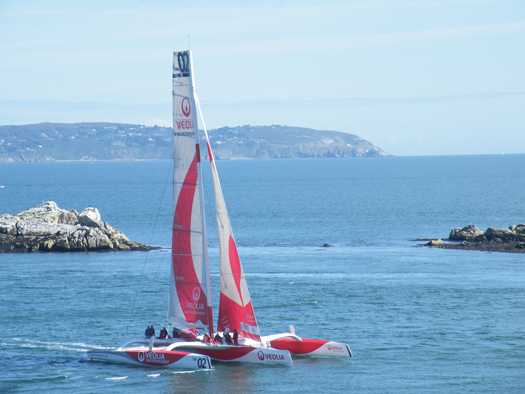
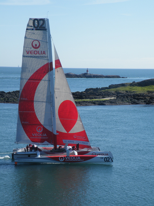
Square Sail's barque Earl of Pembroke was based in Dun Laoghaire Harbour late last year. On one occasion the 174-tonnes barque was seen off The Muglins Lighthouse, Dalkey Island, where a camera-equipped helicopter whirled above the former Baltic Sea trader in Dublin Bay. Following the shoot in Ireland, the production team for the made for TV drama re-located to Puerto Rico in the Caribbean.
Ahoy Me Irish Hearties as “Treasure Island” Sets Sail for TV Screenings

#ON THE TV-It's just over a year ago to when filming took place for parts of the TV Movie "Treasure Island" off Dalkey Island, as previously reported on Afloat.ie. Fans of the classic Robert Louis Stevenson 18th century tale can look forward to this new two-part adaptation starring Eddie Izzard as the one-legged pirate, Long John Silver, on New Year's Day on Sky 1 HD at 7pm and also at the same time on 2nd January, writes Jehan Ashmore.
Joining the Emmy award winning Izzard is BBC TV series Spooks actor Rupert Penry-Jones and Hollywood stars Donald Sunderland and Elijah Wood.
The nautical scenes where set on board Square Sails tallship, the barque Earl of Pembroke which used Dun Laoghaire Harbour as a base. During the Irish scenes, the production crew and members of the cast had to endure the bitterly artic-like conditions of last winter's big freeze as the 174-tonnes barque was off The Muglins Lighthouse with a camera-equipped helicopter whirling above.
Following the shoot in Ireland which involved Dun Laoghaire based Parallel Film Productions and the Irish National Sailing School (INSS) which provided marine co-ordination services for the drama commissioned by Sky 1 HD TV Chanel, the shoot re-located to Puerto Rico in the Caribbean.
To watch a first look-official trailer of the long-awaited swashbuckling adventure click HERE and for more about the drama including a Q&A with the cast click HERE.
- Dublin Bay News
- Treasure Island
- Parallel Film Productions
- Dun Laoghaire Harbour
- Irish National Sailing School (INSS)
- Dalkey Island
- INSS
- Eddie Izzard
- Robert Louis Stevenson
- Rupert PenryJones
- The Muglins
- Maritime TV Programmes
- Sky 1 HD Channel
- TV Movie 'Treasure Island'
- Donald Sunderland
- Eliyah Jones
- On The TV
- BBC TV series Spooks
- Square Sails
- The Muglins Lighthouse
Tanker and Lifeboats Conduct Emergency Exercises off Dalkey Island
Crew kitted in similarly bright orange coloured sea safety-survival suits entered the lifeboat before it plunged into the water. The activity was observed through the binocular-scope which overlooks Coliemore Harbour with excellent views across the sound to Dalkey Island, Dublin Bay and Howth Peninsula.
The binocular-scope does not require payment to operate and was unveiled in 2008 in memory of local resident the late Dr. John de Courcy Ireland, the 'father' of maritime Ireland (to read more click HERE). He was for 26 years a honorary secretary of the local RNLI station in Dun Laoghaire and a staunch campaigner of Irish maritime affairs.
Each Monday a routine lifeboat practice is conducted by the 47ft Trent class ALB (all-weather lifeboat) RNLB Anna Livia (info and PHOTO). Last night's drill also involved the new D-class ILB (inshore lifeboat) RNLB Réalt na Mara which was named earlier this year by Kathy Kenny, wife of RTE presenter Pat Kenny.
Under the cover of darkness the crew of the ILB Realt na Mara simulated an 'injured casualty' on the island where the casualty was prepared to be taken off by stretcher from the island's small harbour. From there the casualty was transferred to the larger RNLB Anna Livia which lay offshore. During the exercise, powerful searchlight beams from the ALB provided essential light to assist in the transfer operation.
Asides the lifeboats, there is plenty of wildlife to observe on the rocky outcrops at Maiden Rock, Clare Rock and Lamb Island, which forms the second largest island after the main island of 22-acres, where a resident herd of goats have been part of the local community for over 200 years.
As for the South Korean built Cumbrian Fisher, she too has close connections with these waters as she was named in Dublin Port in 2005. She is a frequent caller to Dublin bringing bulk liquid products from the oil refinery in Milford Haven, Pembrokeshire which is a major supplier, serving the demands of the capital.
Dublin Port has two oil jetties which cater for four tankers, where bitumen, chemicals, liquid petroleum gases, molasses and oil are handled on a 41-hectare zone with storage for 330,000 product tonnes to include 6,000 tonnes of LPG. In addition aviation fuel is frequently delivered to the terminal to satisfy the constant demand for aircraft using Dublin Airport.
Cumbrian Fisher alongside her sister Clyde Fisher where built for James Fisher & Sons and in recent years they have tended to take anchorage off Dalkey Island and off the Nose of Howth. In comparison the vast majority of vessels anchor in Dublin Bay which is divided into quadrants for the purposes of anchorage allocation.
Before the completion of the South Wall in Dublin Port, which considerably improved safer access of vessels entering the River Liffey, it was the relative deeper and sheltered waters of Dalkey Sound which were used instead as Dalkey acted as the principle port for Dublin between 14-17th centuries.
Vessels would convey cargoes which were taken to and fro by lighter to the coast where it was carried by horse and cart to nearby Dalkey before onward travel across the exposed plains to Dublin City.
To learn more about Dalkey's medieval maritime heritage with its relationship with the capital of Dublin in addition the use of Dalkey Quarry in the construction of (Kingstown) Dun Laoghaire Harbour, visit the Dalkey Castle & Heritage Centre. To read more go to www.dalkeycastle.com in addition to further information about Dalkey including the local community council newsletters click HERE.
- Dublin Bay
- Dublin Airport
- Dublin Bay News
- Commissioners of Irish Lights
- Irish Lights
- coliemore harbour
- Pembrokeshire
- Dalkey Island
- Port of Dublin
- River Liffey
- Ports and Shipping News
- The Muglins
- Coastal Notes
- Howth Peninsula
- Pat Kenny
- Dalkey Sound
- Lighthouse news
- Irish Lighthouses
- Cumbrian Fisher
- Jas Fisher & Sons
- Clyde Fisher
- Milford Haven Oil Refinery
- Dalkey Castle & Heritage Centre
- Dr. Ireland
- Dr. John de Courcy Ireland
- Irish maritime historian
- Kingstown Harbour
- Kathy Kenny
- RTE presenter Pat Kenny
- South Wall Dublin Port
- Medieval Dalkey
- Dalkey Quarry
- Aviation fuel
- Dalkey Tidy Towns Committee
- Nose of Howth
- Dublin Port Oil Jetty Terminal
- Dalkey Community Council
- Dalkey Island Goats
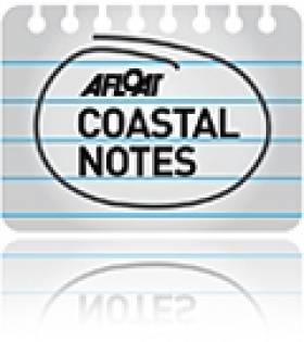
Veolia Environnement Clocks 15 Knots on Dublin Bay
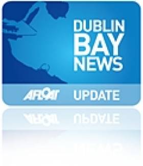
The exotic French Trimaran Veolia Environnement was in Dalkey Sound this morning. The high speed craft circled around the island in modest north westerly winds and returned into Dublin Bay for what appeared to be a helicopter publicity-photoshoot. According to vessel tracking system she got up to 14.8 knots and no doubt more!
Veolia Environnement sails briskly down Dalkey Sound. Photo: Jehan Ashmore
“Treasure Island” Sea-Scenes Start Shooting

Earl of Pembroke with helicopter above off The Muglins. Photo. Jehan Ashmore/ShipSNAPS
The two-part production starring Emmy award winning actor Eddie Izzard, is to play the role of iconic one-legged pirate, Long John Silver in the classic Robert Louis Stevenson 18th century tale of adventure and treasure. Also starring is Rupert Penry-Jones, best known for his spy role in the BBC TV series Spooks.
Since arrival to Dun Laoghaire in mid-November the 145-foot Earl of Pembroke has been undergoing modifications at the Carlisle Pier in preparation of the film. The barque is owned by the Cornwall based SquareSail which specialises in tall ships for film productions. The ship's silver-screen credits include Cutthroat Island, Frenchman's Creek, Hornblower Series III and Longitude.
The Treasure Island shoot involves two Dun Laoghaire based companies, Parallel Film Productions and the Irish National Sailing School (INSS) which is providing marine co-ordination services. The drama was commissioned for the Sky 1 HD TV channel and the director is Steve Barron (Arabian Nights, Merlin, England Manager).
The production follows 'Neverland' a two-part prequel to the Peter Pan story also produced by Parallel Films. Neverland was shot on the coast at Dalkey Sound, Killiney Hill in Co. Dublin and neighbouring Co. Wicklow. Both productions are part of a multi-million pound investment by Sky for their high-definition (HD) drama department.
In the New Year the Treasure Island production moves to Puerto Rico in the Caribbean. The drama is scheduled to be released in Christmas 2012.
Looking for further reading on Tall Ships in Ireland? Click the links below:
Click this link to read all our Tall Ships Stories on one handy page
Previewing Ireland's Tall Ships 2011 Season
Can Ireland Get a New Tall Ship?


 as lead helm, rounds the Fastnet Rock on the way to the overall win in 1987")

