


Displaying items by tag: guide
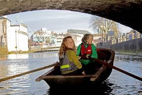
A unique new tidal guide assisting river users to circumnavigate the city’s waterways was launched yesterday at the River Lee Hotel. CORKUMNAVIGATION is a pocket-sized map published by Cork’s community boatyard, Meitheal Mara. The guide is aimed at helping locals and visitors alike discover the city from a new angle by kayak, canoe or rowing boat. See link below to purchase the guide.
According to Cathy Buchanan of Meitheal Mara, ''very few people know that you can actually row or paddle all around the city, and experience a very different and special side of Cork. As several of the bridges are particularly low and some weirs quite high, they can only be passed at certain tides. With the CORKUMNAVIGATION guide you can successfully navigate the city’s 29 bridges and eight weirs at various stages of the tide.''
Niamh Twomey, Cork City Council Heritage Officer, added ''The River Lee is one of the great unexploited spaces in Cork, offering a beautiful route around the historic city centre. This guide will give the growing number of river users the opportunity to experience the natural and built heritage of Cork from the River Lee. The guide also includes quirky historical facts contributed by the late Cían Ó Sé.''
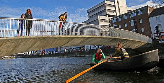
Corkumnavigate Cork city's 29 bridges and eight weirs with this latest pocket guide.
Originating near Gougane Barra in the Shehy Mountains, the River Lee flows east towards Cork City where it splits into two channels, forming the city's central island. Medieval Cork was a network of small river channels, which over the centuries have been covered in to leave just the north and south channels open. The river derives its name from the Irish "Laoi", meaning torrent or flood.
CORKUMNAVIGATION is a Meitheal Mara project, sponsored by Cork City Council and the River Lee Hotel. Fieldwork for the project was conducted in 2010 by the Cork Centre for Architectural Education, UCC and CIT, and sponsored by the Heritage Council.
The CORKUMNAVIGATION guide is available from Meitheal Mara via Afloat's Marine Market. Click HERE.
New Angling Guides and Salmon Bait Restrictions

#Angling - Inland Fisheries Ireland has recently added two new guides to its list of resources for anglers fishing in Ireland.
The West of Ireland Sea Angling Guide covers the region from Westport, in Clew Bay, south to the rocky headlands of North Clare, including Galway Bay, Connemara, Killary, Louisburgh, Clew Bay, and the offshore islands of Inisbofin, Inisturk and the Aran Islands.
The guide is in no way comprehensive, and the list of marks and venues is just a sample of what is available across the region's waterways. There are literally hundreds of shore marks in the region that have rarely, if ever, been fished, but the potential waiting to be explored is immense. Getting off the beaten path and trying a new mark may produce the fish of a lifetime.
In addition, the County Sligo Game Angling Guide covers the main game angling waters in the district. It contains information on the location of each fishery as well as details in relation to contacts, permitted angling methods, angling seasons, etc.
Meanwhile, IFI has received numerous submissions from individual anglers, angling organisations and angling tourist providers regarding restrictions on the use of prawn/shrimp as a salmon angling bait on the River Suir for the 2013 season.
IFI is interested to hear the views of other angling stakeholders or from those who wish to make further submissions.
Submissions can be made to IFI Clonmel by email at [email protected] or by post to Inland Fisheries Ireland, Anglesea Street, Clonmel, Co Tipperary.
The closing date for receipt of submissions is 28 February 2013.
#INLAND – Waterways Ireland, together with food writer Georgina Campbell and Afloat's boating expert W.M. Nixon, recently launched the 2012 edition of A Taste of the Waterways. The Guide recommends places to eat and stay along the inland waterways managed by Waterways Ireland, and also includes maps and information on Things to See & Do along the way.
Establishments featured are independently assessed and recommendations are made on merit alone, with no fee charged for inclusion.
Georgina, who independently compiled the Taste guide, states "The 2012 Taste of the Waterways guide will introduce a lot of new visitors to a side of Ireland that is still unknown to many and what a wonderful surprise they have in store...Our beautiful rivers and canals lead the visitor right to the heart of Ireland and there is a special timeless quality to the way of life here. Community spirit is strong, visitors are made very welcome and, as well as a healthy choice of outdoor activities and sites to see, there's always plenty of music and craic to be found in friendly pubs along the way - also a generous sprinkling of good eating places, of course, and some lovely places to stay."
Featuring over 110 businesses along the 1000km of Ireland's inland waterways, the guide recommends selected establishments within a corridor along the Barrow Navigation, the Erne System, the Lower Bann, The Grand Canal, the Royal Canal, the Shannon-Erne Waterway and the Shannon Navigation.
Speaking about the guide Éanna Rowe, Head of Marketing & Communications with Waterways Ireland, highlighted 'This guide to selected food and hospitality premises along the waterways is not only for the boating public but also for those who come to walk, fish, canoe, cycle or sightsee along the beauty of the waterways and encourages them to stay, eat and spend more money in this environment. 'A Taste of the Waterways' provides a true experience of our inland waterways.'
The guide is free of charge and copies have been distributed to all registered boat owners and to tourist information centres nationwide.
In addition Waterways Ireland has developed a What's On Guide to give a listing of all the events taking place along the waterway corridor throughout the boating season and promote the use of the waterways by residents and tourists alike. Some of the events listed are also sponsored by Waterways Ireland and many feature a 'Come and Try It' session to encourage people of all ages to experience the waterways for themselves.
New Angling Guide for Lough O'Flynn and Upper Suck
#INLAND WATERWAYS - Inland Fisheries Ireland (IFI) officially launched the Lough O’Flynn and Upper Suck Angling Guide at the Old Stonehouse Restaurant in Ballinlough recently.
The guide opens to Lough O'Flynn, a 300-acre limestone lake situated 2km from Ballinlough and one of IFI’s many managed lakes requiring a permit.
This lake holds a stock of wild brown trout and is also stocked with brown trout each year which provides an excellent opportunity for all kinds of anglers and those wishing to take up the sport to learn how to fish for trout.
Meanwhile, the centrefold of the guide showcases the Upper Suck catchment from Lough O’Flynn through Co Roscommon and Galway until the Shiven tributary joins, along which good quality coarse, pike and trout angling can be expected.
With breathtaking scenery, this is the perfect place for anglers who can fish almost undisturbed from dawn till dusk.
There are also a considerable number of sections dedicated to anglers with disabilities, such as the Donamon angling stretch which has 30 fishing stands available with individual car parking bays and toilet facilities. This section has proven extremely popular, and IFI says it is committed to ensuring that sections like Donamon continue to open fishing up for everyone.
Amanda Mooney, director at IFI, said: “The guide offers a great source of information on angling hotspots for various types of species, access points and facilities, legislation and safety.
"All in all everything you need for planning a fishing trip. The guide and angling promotion in general supports local businesses and communities in sustaining jobs.”
The Lough O’Flynn and Upper Suck Angling Guide is available from IFI outlets and local permit agents in Ballinlough, Co Roscommon.
Inland Fisheries Ireland also marked the retirement of John Ryan, assistant inspector for Lough O’Flynn and the Suck catchment, after 41 years of service.
Ryan was involved in many areas and aspects of fisheries throughout his career, and was particularly noted for his positive engagement with various groups from angling clubs and development associations to local authorities, businesses and communities.
#MCIB - The decision to set out in poor weather, coupled with limited safety instruction, led to the tragic death of a Romanian angler on Lough Mask last summer, according to a report by the Marine Casualty Investigation Board (MCIB).
Mircea Ungur drowned after the angling boat he was in capsized in choppy waters brought on by squalling Force 8 winds on the afternoon of 8 May 2011.
Ungur had a tracheostomy tube in his throat resulting from a previous battle against throat cancer, and drowned after taking in water through this tube, the MCIB concluded. It was also found that most of his companions and the guide knew nothing about the tube.
At the time of the incident, Ungur had been on an angling holiday in Co Mayo with five colleagues accompanied by a fishing guide. On the morning of 8 May the group set out from Cappaduff in Tourmakeady on two boats, following a brief discussion about fishing and safe departure from the pier.
Winds were already reaching Force 4-6 when the group departed and sought a sheltered area of the lough to fish. After lunch winds had picked up to Force 8 and the guide signalled for a return to Tourmakeady.
At around 1.5km from the pier at Cappaduff, a wave swamped the leading boat that contained Ungur, a companion and the guide. All three on board, who were wearing buoyancy aids, went into the water.
Ungur was the first taken on board the other boat after some 10 minutes in the water. He was not moving or communicating with the others, and CPR was not administered until the boat reached the shore 20 minutes later. Ungur was pronouced dead just before 3pm.
The report concluded that the group had departed despite reservations among them about the poor weather, which had been correctly forecast that day. There was also little discussion with the anglers about their level of boating experience, the weather, or any disabilities that would affect their safety on the water.
The MCIB recommended that a full safety briefing should be given to all those hiring angling boats. It also urged the enforcement of safety regulations and certification for recreational water craft.
The full report is available to download as a PDF from the MCIB website HERE.
Get Canoeing for National Trails Day in NI This Weekend
No less than nine free guided canoeing events will be taking place across Northern Ireland this Sunday 2 October to celebrate the fourth annual National Trails Day.
According to Northern Ireland's Outdoor Adventure Blog, all the events will be guided by qualified canoeing instructors, with all canoe rental and safety equipment provided free of charge.
So there's never been a better time to get a paddle in your hands and take to Northern Ireland's wealth of waterways.
As previously reported on Afloat.ie, the new Foyle Canoe Trail will be among those where novices can get a taste of what Northern Ireland's canals and rivers have to offer.
OutdoorNI.com has more about the free guided canoe trails available HERE.
New Guide Service for Fly Fishing in Cork Harbour

A new guide service is now available for anyone wishing to sample bass and saltwater fly fishing on Ireland's south coast.
World Sea Fishing reports on Cork Harbour-based Richie Ryan, a specialist fly fishing guide who pilots the first boat fully licenced for saltwater fly fishing in Ireland.
Aboard the Sea Hawk, Ryan will impart his expert knowledge in catching bass, sea trout, mullet, pollack, mackerel and garfish, among others, in the waters of Cork Harbour.
According to World Sea Fishing's Mike Thrussell, guides such as Ryan "will become an essential part in sustaining the future of Irish bass fishing and their conservation".
For further details call 021 481 1103 (mobile 086 194 0744), e-mail i[email protected] or visit www.corkbass.com.
Finding Long-Term Value for Boat Buyers

BoatTest.com has posted a guide to getting the best long-term value from your next boat purchase.
With boat buyers increasingly seeing their purchases as personal assets and investments for the future in this tough economic climate, making the right choice is more important than ever.
'Long-term value' is the key phrase. It's not just about price, but fitting the needs of the owner, and depreciating less than the average boat in the class - even after many years of enjoyment.
The site reminds boat buyers to remember the difference between 'type' and 'class' when comparing models, and its ten-point guide breaks down everything you need to know when choosing a boat for enduring value.
Read the BoatTest.com guide to long-term value in boat buying HERE.


 as lead helm, rounds the Fastnet Rock on the way to the overall win in 1987")


