


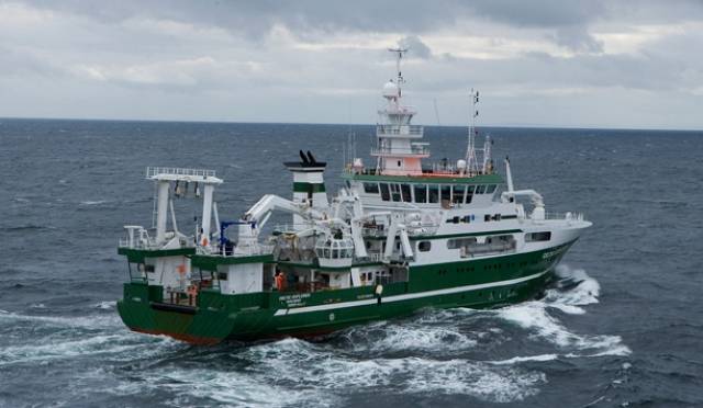
Ireland's national research vessel, the R.V. Celtic Explorer will set sail this evening from St. John’s, Newfoundland and Labrador, (8pm Newfoundland/11:30pm Ireland), where last June it launched the very first seabed mapping expedition under the Atlantic Ocean Research Alliance.
The survey takes place May 11-21 with graduate students and early career researchers representing Europe (Ireland), Canada and the United States joining a team of international experts to map some 12000km2 of un-surveyed seafloor from the deepest parts of the Atlantic Ocean. Ireland’s national seabed mapping programme, INFOMAR launched a travel bursary called the Atlantic Seabed Mapping scholarship, AtSeaMap, to help support student researchers to come onboard.
This is the fourth seabed mapping survey to take place under the Atlantic Ocean Research Alliance. Xavier Monteys, Geological Survey of Ireland, will lead a team of 12 international scientists, who will map a transect of the Atlantic seafloor between St. John’s, Newfoundland, and Galway, Ireland. Together they will investigate discoveries from previous expeditions,while training the next generation of young seabed mappers through an innovative series of ocean research training delivered on-board.
Koen Verbruggen, Director, Geological Survey of Ireland (GSI) and Dr Peter Heffernan, CEO Marine Institute, the partner organisations delivering the INFOMAR programme, welcomed the survey and the introduction of AtSeaMap.
Koen Verbruggen said: “The INFOMAR scholarship, supporting European, US, and Canadian student participation, is a key step towards developing expertise, sharing knowledge, and raising awareness of the integral role of the Atlantic Ocean in each and every one of our daily lives.”
Dr Peter Heffernan added, “The Atlantic Ocean influences our lives in many different ways from climate, environment, energy, transport, telecommunications, to food on our tables. It’s our maritime highway. Amazingly, we just don't yet have the roadmap. AtSeaMap provides a unique opportunity for students from Europe, Canada and the USA to be part of a significant initiative to begin to build comprehensive maps of the Atlantic Ocean. ”
The survey supports the Galway Statement on Atlantic Ocean Cooperation, the goals of which are to join the resources of its three signatories to better understand the North Atlantic Ocean, to promote sustainable management of its resources, and to promote citizens’ understanding of the Atlantic through ocean literacy.
Dr Heffernan, who is the coordinator of the Atlantic Ocean Research Alliance Coordination and Support Action, added: “This survey and those to follow will make a significant contribution towards delivering on commitments made in the Galway Statement and represent an important stepping stone to building a comprehensive mapping campaign for the Atlantic Ocean.”
The survey is called TRASNA, which is the Irish word for “crossing" and stands for Trans-Atlantic Survey North-Atlantic. The scientific team and students will blog about their experience on the RV Celtic Explorer on www.atlanticresource.org/aora/trasna where you can follow their progress across the Atlantic or use #TRASNA.
The early stage researchers joining the survey as part of the AtSeaMap initiative are Jamie Maxwell, National University of Ireland Galway, Ireland; Peter MacIntosh, Memorial University, Newfoundland and Labrador, Canada; and Rachel Wireman, College of Charleston, USA.
The Canadian Coast Guard vessel Louis St. Laurent will build on this work later this summer sailing from Halifax, Nova Scotia, Canada on 22 July and due to arrive in Tromsø, Norway 5 August.
The INFOMAR Atlantic Seabed Mapping scholarship, AtSeaMap, is funded by the Department of Communications, Energy and Natural Resources.
The Marine Institute is leading the Horizon 2020 funded project -The Atlantic Ocean Research Alliance Coordination and Support Action – to support the implementation of the Galway Statement, signed at the Marine Institute, Oranmore 24th May 2013.


 as lead helm, rounds the Fastnet Rock on the way to the overall win in 1987")


 Michael Murphy Schull Harbour Sailing Club (SHSC), Eric Coogan Heineken Ireland, Mark Murphy, Commodore SHSC, Jack Allen SHSC, Carmel O'Regan SHSC, Cornelious Ndlovu, Schull Harbour Hotel Operations Manager and Derval Murphy SHSC")
