


What is the number one topic of conversation in Ireland? We all know the answer: It’s the weather. We also know that the forecasts we hear on the radio or see on the telly are, shall we say, not always quite accurate. Some might even say they are only valid for Dublin. And when have you ever heard ‘them’ say “there will be sunshine spreading from the west”? Wait no longer. Now you can go to the Mayo Sailing Club website to get a full picture of what the weather is doing now and about to do in the near future.
 MayoSailingClub.com website showing the menu to the Anemometer
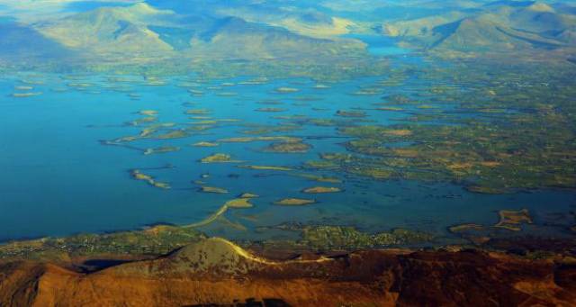
In County Mayo, those in the know have long relied on resources other than the weather service to get their fix. For years, the Mayo Sailing Club (MSC) anemometer has been used by the RNLI and Coastguard as well as many fishermen and farmers for an accurate picture of what is happening with the wind on Clew Bay at a given time. Windguru has also been a favourite for local weather forecasts with people checking out the Bertra and Mulranny “spots”.
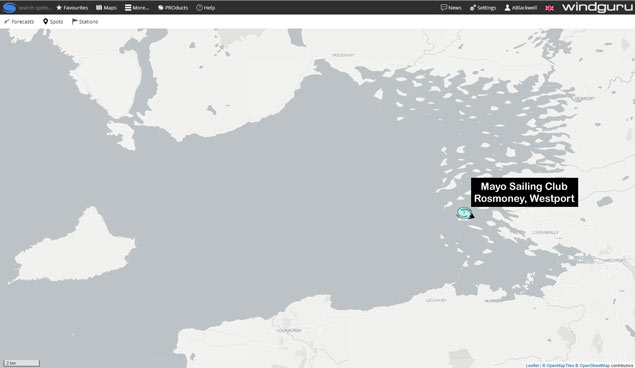 Location of the Mayo Sailing Club weather station on Inishlyre Island in Clew Bay
Windguru was originally conceived for surfers who wanted accurate weather and wave forecasts. Whereas there are many “spots” where Windguru forecasts can be looked up on the web or in the app, there have to date only been seven actual weather “stations” where wind, rain and temperature data is collected and used in their forecasting models; these were in the east and south of the country. The forecasts for the weather “spots” here in Clew Bay and elsewhere were extrapolated from these remote “stations”.
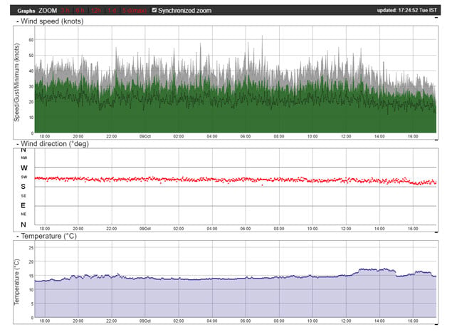
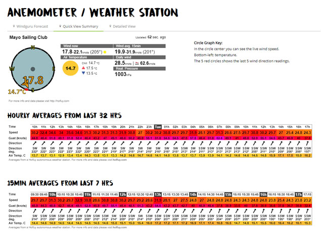 The current weather at the Mayo Sailing Club weather station on Inishlyre Island in Clew Bay under the ‘Quick View Summary’ tab
Westport is now the centre of weather forecasting for the Wild Atlantic Way
Mayo Sailing Club has completed a significant upgrade to its weather station. By upgrading the physical weather station technology, the detailed live data from the station can now be shared with global weather forecasting networks such as Windguru. This is a significant development as it means that visitors to MayoSailingClub.com and users of Windguru can now get detailed and accurate information on the weather we are currently experiencing as well as on the trends that led to this, resulting in much more accurate predictions as to the weather we are likely to get in the coming hours and days. To view the data, which includes current wind strength, wind direction, variability of wind direction, precipitation (rain), cloud cover, temperature, air pressure, and light levels, as well as the current webcam view from Inishlyre Island, just navigate to the MSC Anemometer page and click on “Detailed View & Graphs”.
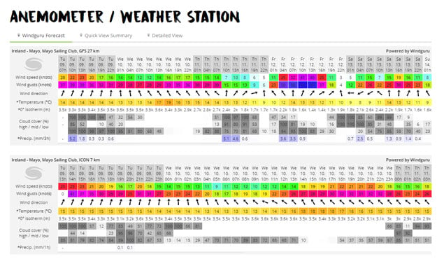 A sample of the ‘Windguru forecast’ tab showing the longer range GFS 27 prediction and the ICON 7 three day prediction.
 The current weather at the Mayo Sailing Club weather station on Inishlyre Island in Clew Bay under the ‘Quick View Summary’ tab
Current Weather and Forecasts
A visitor may also click on the “Windguru Forecast” tab to get a detailed forecast. This is based on the actual current situation and trends. It is therefore as accurate as it can be based on the most current meteorological prediction models. Usefully for Ireland, it also includes rainfall predictions. While this data can appear a little daunting at first, what you are seeing are several different weather prediction models which are summarised below:
GFS Model
GFS stands for the Global Forecast System. It is run by National Centers for Environmental Prediction, USA. The GFS is run four times per day and is a global model so it covers the entire Earth! Since January 2015 GFS produce forecasts with resolution of 27 km out to 240 hours.
WRF Model
The Weather Research and Forecasting (WRF) Model is also US based. It is a next-generation mesoscale numerical weather prediction system designed to serve both operational forecasting and atmospheric research needs.
ICON Model
The European Global ICON Model is the newest and some would argue, the most accurate. ICON 13 covers the planet and offers forecasts in 3 hour steps for the next 180 hours, updated 4 times per day. The regional ICON 7 model with 7 km resolution covers Europe with forecasts in 1 hour steps for the next 78 hours.
Remember, these are different computer programs using the currently available information to predict the future, so inevitably their predictions will differ slightly. Despite that, you may be surprised by just how reliable they are – particularly the ICON 7 and WRF 9 models, which give you the next three days. They will often accutately predict rainfall to the hour. The fact that these predictions are now using live information gathered by Mayo Sailing Club means that the forecasts will be much more reliable than in the past when they were extrapolated from weather stations that were hundreds of miles away. The next time you chat with friends and family about the weather you will have the opportunity to dazzle and amaze with your own astonishingly accurate predictions!
Location
Courtesy of the Gibbons Family of Inishlyre Island, the Ultrasonic Anemometer has been located 27 meters above sea level on the island’s summit 53° 49.5'N 9° 39'W. This provides a clear view of all quarters enabling a representative sampling of the local wind in Clew Bay.
Principle of Operation
The can-sized wind sensor measures the time taken for an ultrasonic pulse of sound to travel from the North transducer to the South transducer and compares this with the time for a pulse to travel from S to N transducer. Likewise, times are compared between the W and E and the E and W transducers. If for example, a Northerly wind is blowing, then time taken for the pulse of sound to travel from N to S will be faster than from S to N, whereas the E to W and W to E times will be the same. The wind speed and direction are then calculated from the differences in the times of flight on each axis. This calculation is independent of error sources such as temperature and mechanical friction etc. Being solid state (no moving parts) the anemometer is virtually maintenance free. It is powered by battery which is kept charged by a large solar panel.
Using a data logger and a modem the data is sent via GPRS and the internet to a remote computer where the Wind Speed and Direction for the last 8 hours are displayed on two graphs which scroll forward with time.
Data is collected every 30 seconds and the graphs are updated every 5 minutes when the remote computer polls the data logger. These real-time graphs are available on www.mayosailingclub.com for members and guests to check the current local weather at Clew Bay anytime. This is an important safety feature for members and the general public who use Clew Bay.
For more information on what the weather is going to be like visit: www.mayosailingclub.com


 as lead helm, rounds the Fastnet Rock on the way to the overall win in 1987")


 Michael Murphy Schull Harbour Sailing Club (SHSC), Eric Coogan Heineken Ireland, Mark Murphy, Commodore SHSC, Jack Allen SHSC, Carmel O'Regan SHSC, Cornelious Ndlovu, Schull Harbour Hotel Operations Manager and Derval Murphy SHSC")
