Menu

Ireland's sailing, boating & maritime magazine

Dublin Bay Boating News and Information

Displaying items by tag: 'Coaster' first

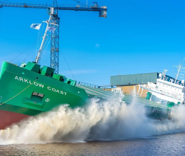
Once again the newest C-class series of short-sea traders for Arklow Shipping, launched in a shipyard in The Netherlands, has been given a ship name first for the Co. Wicklow based shipowner, writes Jehan Ashmore.

On this occasion, Saturday's launch of the 5,054dwat newbuild saw the Arklow Coast take to the waters of the Winschoterdiep canal at Ferus Smit's shipyard at Westerbroek. 

The new 87m cargoship will further modernise ASL's almost 60-strong Irish-Dutch flagged fleet, that includes deep sea ocean going bulkers, the largest been a pair of S-class, each of 34,905dwat. In addition to the dwindling R-class of 4,933dwat. Among them the oldest, Arklow Rainbow which Afloat observed depart Dublin Port last week when bound to Northfleet, London.

As for the new Irish-flagged C-Class cargoships, they are given names beginning with the letter 'C'. Such newly created names having differred to previous generations of tonnage dating back to the 1980's. An exception to the nomenclature has been Arklow Castle (see 'European' trader) which follows two predecessors taking this same name.

The previous 'Castle' built for ASL and dating to 1996, was notably a 'containership' which is a rarity for ASL operations, having served a 'liner' service linking the UK, Ireland and Spain. This lo-lo link was discontinued following ASL's disposal of the 532TEU capacity containership.

Whereas, the original Arklow Castle built in 1981 was secondhand tonnage for ASL, until its career ended dramatically when it became wrecked more than a decade later at Sables d'Olonne on the west coast of France.

As for the current Arklow Coast, which represents the 8th of 10 C-class cargoships ordered by ASL and follows Arklow Cloud which Afloat reported late last year also launched at Westerbroek.

A maximized single hold equates to a volume of 220,000 cft and a carrying capacity over 5000 deadweight tons. The newbuild has been given a 1A ice class notation and is propelled by a 1,740 kW MaK engine with a single ducted propeller.

The straight-stemmed bow is equipped with a 275kW electric bowthruster to assist operations in port. Related to that Afloat today tracked several of the C-class cargoships located to ports in north-west Europe, the Baltic Sea and trading in the western Mediterranean.

Published in Arklow Shipping

Dublin Bay

Dublin Bay on the east coast of Ireland stretches over seven kilometres, from Howth Head on its northern tip to Dalkey Island in the south. It's a place most Dubliners simply take for granted, and one of the capital's least visited places. But there's more going on out there than you'd imagine.

The biggest boating centre is at Dun Laoghaire Harbour on the Bay's south shore that is home to over 1,500 pleasure craft, four waterfront yacht clubs and Ireland's largest marina.

The bay is rather shallow with many sandbanks and rocky outcrops, and was notorious in the past for shipwrecks, especially when the wind was from the east. Until modern times, many ships and their passengers were lost along the treacherous coastline from Howth to Dun Laoghaire, less than a kilometre from shore.

The Bay is a C-shaped inlet of the Irish Sea and is about 10 kilometres wide along its north-south base, and 7 km in length to its apex at the centre of the city of Dublin; stretching from Howth Head in the north to Dalkey Point in the south. North Bull Island is situated in the northwest part of the bay, where one of two major inshore sandbanks lie, and features a 5 km long sandy beach, Dollymount Strand, fronting an internationally recognised wildfowl reserve. Many of the rivers of Dublin reach the Irish Sea at Dublin Bay: the River Liffey, with the River Dodder flow received less than 1 km inland, River Tolka, and various smaller rivers and streams.

Dublin Bay FAQs

There are approximately ten beaches and bathing spots around Dublin Bay: Dollymount Strand; Forty Foot Bathing Place; Half Moon bathing spot; Merrion Strand; Bull Wall; Sandycove Beach; Sandymount Strand; Seapoint; Shelley Banks; Sutton, Burrow Beach

There are slipways on the north side of Dublin Bay at Clontarf, Sutton and on the southside at Dun Laoghaire Harbour, and in Dalkey at Coliemore and Bulloch Harbours.

Dublin Bay is administered by a number of Government Departments, three local authorities and several statutory agencies. Dublin Port Company is in charge of navigation on the Bay.

Dublin Bay is approximately 70 sq kilometres or 7,000 hectares. The Bay is about 10 kilometres wide along its north-south base, and seven km in length east-west to its peak at the centre of the city of Dublin; stretching from Howth Head in the north to Dalkey Point in the south.

Dun Laoghaire Harbour on the southside of the Bay has an East and West Pier, each one kilometre long; this is one of the largest human-made harbours in the world. There also piers or walls at the entrance to the River Liffey at Dublin city known as the Great North and South Walls. Other harbours on the Bay include Bulloch Harbour and Coliemore Harbours both at Dalkey.

There are two marinas on Dublin Bay. Ireland's largest marina with over 800 berths is on the southern shore at Dun Laoghaire Harbour. The other is at Poolbeg Yacht and Boat Club on the River Liffey close to Dublin City.

Car and passenger Ferries operate from Dublin Port to the UK, Isle of Man and France. A passenger ferry operates from Dun Laoghaire Harbour to Howth as well as providing tourist voyages around the bay.

Dublin Bay has two Islands. Bull Island at Clontarf and Dalkey Island on the southern shore of the Bay.

The River Liffey flows through Dublin city and into the Bay. Its tributaries include the River Dodder, the River Poddle and the River Camac.

Dollymount, Burrow and Seapoint beaches

Approximately 1,500 boats from small dinghies to motorboats to ocean-going yachts. The vast majority, over 1,000, are moored at Dun Laoghaire Harbour which is Ireland's boating capital.

In 1981, UNESCO recognised the importance of Dublin Bay by designating North Bull Island as a Biosphere because of its rare and internationally important habitats and species of wildlife. To support sustainable development, UNESCO’s concept of a Biosphere has evolved to include not just areas of ecological value but also the areas around them and the communities that live and work within these areas. There have since been additional international and national designations, covering much of Dublin Bay, to ensure the protection of its water quality and biodiversity. To fulfil these broader management aims for the ecosystem, the Biosphere was expanded in 2015. The Biosphere now covers Dublin Bay, reflecting its significant environmental, economic, cultural and tourism importance, and extends to over 300km² to include the bay, the shore and nearby residential areas.

On the Southside at Dun Laoghaire, there is the National Yacht Club, Royal St. George Yacht Club, Royal Irish Yacht Club and Dun Laoghaire Motor Yacht Club as well as Dublin Bay Sailing Club. In the city centre, there is Poolbeg Yacht and Boat Club. On the Northside of Dublin, there is Clontarf Yacht and Boat Club and Sutton Dinghy Club. While not on Dublin Bay, Howth Yacht Club is the major north Dublin Sailing centre.

© Afloat 2020