Menu

Ireland's sailing, boating & maritime magazine

Displaying items by tag: Cork Week Winning

17th December 2009

Cork Week and How You Can Win

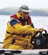
eddie_english.jpgHow you can win at Cork Week

with more than a little help from local expert Eddie English [pictured left]Cork Week 2004 (reprinted from Afloat July 2004). For all the up to date information and news on Cork Week click here.

Eddie English stands high on Cobh’s historic waterfront and looks out across Cork Harbour, south towards Roche’s Point Lighthouse and the entrance to the natural sanctuary. Immediately below, a huge Brittany Ferries ship heads slowly out to sea; it’s not even close in size to a previous visitor to the former Queenstown, but then again, the RMS Titanic belonged to a different era.

To his left, the inshore waters north of the Whitegate oil refinery hide the channel to East Ferry where the Marlogue Inn stands over its marina and just opposite, the legendary Murphs on the mainland shore.

On his right, the channel between Spike and Haulbowline Islands and Cobh is the main shipping route for the Port of Cork for ferries, commercial shipping and the Irish Naval Service base.

But it’s the view straight out to sea that confirms one of the magic ingredients that have made Cork Week an international regatta of worldwide repute: vast tracts of open, unobstructed water and all within easy reach of the shoreside facilities of the hosts at the Royal Cork Marina at Crosshaven.

When it comes to local knowledge, few are as expert as English. Not only is he chairman of the event's racing committee, not only does he run a long-established sailing school in the harbour, but when you are offered an insight from someone who takes his dog for a walk on notorious mud banks at low water springs, they tend to be nuggets of the golden variety.
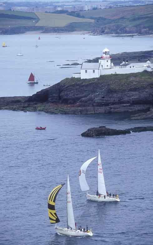
crk01.jpg
Left: Sigma 33s negotiate Roche’s Point

"The harbour course is the key to Cork Week," says English. "It's the decider where the event is won or lost and has the most variables involved." So this, then, is the Eddie English step-by-step guide to gaining an edge for that course, plus the coastal, wind/leeward and Olympic-type courses at Cork Week 2004.


Harbour Race

Above all, be conservative at the start of the Harbour Race if the tide is with you on the start off Weaver's Point. There can be two knots of tide here typically and an OCS in any fleet represents the end of the story with recovery improbable. Ideally, a short tour of the harbour during the weekend registration stage of Cork Week will pay dividends. If you can, borrow a RIB and take the tour at low-water.

Two marks form part of this course outside the harbour and rounding order will depend on wind-direction on the day. The first is off Ringabella to the south-west shore heading towards Kinsale. If there’s a flood tide, hug the shore. In fact, if the breeze is SW, go right, even in an ebb.

The second is off Trabolgan, east of Roche's Point. Crucially, beware of the strength of tide when traversing the channel across the harbour entrance. Don't just rely on the GPS – plot the tidal vectors to find the true course to steer. Once to the east of Roche's Point, there’s negligible tide and often a tide line can be observed.

This course then takes the fleet into the harbour but beware when entering on the east side of the Harbour mouth – the Cow and Calf rocks are extensions of Roche's Point up to one cable off the shore.
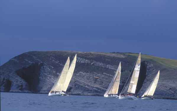
crk05.jpg
Above: Hugging the shoreline for a tactical advantage

Most races will come into a buoy east of Cobh, making this a long leg in, but offer plenty of hazards on a falling tide. After the Cow and Calf, it’s possible to dodge into White Bay but be wary of rocks and shallows on the south end of the bay close to Roche's Point.

The Dog's Nose promontory is next and it’s possible to cut into the area north of here though close inshore it shallows and the Black Rock is marked by a perch as the main hazard.

Bear in mind the sailing instructions that require clearance of 50 metres off the oil refinery jetty at all times. A listening watch on VHF Ch. 12 is useful for avoiding shipping.
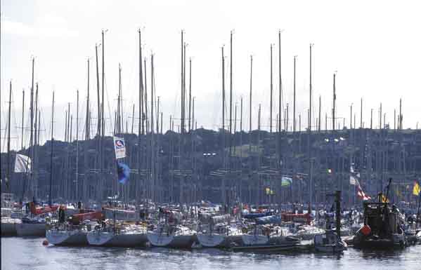
cork04.jpg

Above: The fleet at anchor – everyone’s gone to the pub...

Once past the refinery jetty, the tide running north-east/south-west for the East Ferry channel can suck you in or push you out.

The alternative to the eastern shore approach is to hug the western shore and involves rock-hopping from Ringabella in past Weaver's Point. An option is to duck into the Owenbue River at Crosshaven – the tide ebbs here up to 30–40 minutes before HW Cobh.

North of here, the Curlane Bank, south of Spike Island, offers an option but beware of shallows. The area south-east of Spike is littered with rocks and, in particular, off the eastern end is a large rock marked by a perch.

The Spit Bank is the biggest in the harbour and is located from the north end of Spike from the lighthouse to the corner off Haulbowline. On very low spring tides, football is played on this bank. The key here is: go as close as you dare. The bank is mostly mud except for ‘The Seven Stones’ aka The Ballast Rocks located approximately two cables east south-east of the No. 20 (Port) Buoy.

Having made the turn for the final approach to the Cobh rounding buoy, one of the showcase marks in the entire event set beneath the picturesque back-drop of the town, this leg from ‘Cuskinny Turn’ offers several options in tide. With the tide is a straight-forward matter of choosing the deepest water so check the charts. Usually, the north shore offers no significant gains. Keep a sharp watch for the passenger ferries running from Cobh to Spike and Haulbowline Islands.

From Cobh, the Harbour Race will have a new finishing line in 2004, moving to the No. 7 (starboard) buoy south of the refinery.


Coastal Course

Going west from the start in a south-westerly or filling sea-breeze, taking the right-handside of the course, pays off, thanks to lifts off the shore. Use the bays to get out of the tide, with the exception of the first bay after Robert's Head/Daunt buoy – it’s called Rocky Bay and it is!

The tide here follows a south-west/north-east direction in line with the heads with a one-knot maximum. Keep the harbour entrance strategy from the previous course notes in mind too.

For 2004, the former south-east mark located approximately three miles east of Roche's Point has been renamed Moonduster as a tribute to the late Denis Doyle and his legendary 51-foot yacht that is synonymous with Cork.  


All Courses

The Olympic and windward/leeward are located outside the harbour so allow plenty of time to get afloat – some courses could take you up to an hour to reach as the number of yachts leaving Crosshaven at one time can mean congestion. The furthest course is three miles south-east of Roche's Point which in turn is two miles from Crosshaven. Don't assume the Race Officers will wait – best advice is to follow the professionals' example and leave early to be at sea on time with an opportunity to practice a few crew drills.

These courses usually have no significant tidal factors as most are located outside the harbour and beyond the main entrance tide line. More importantly, if a sea breeze builds, this will be of more use to you.

If a sea-breeze applies, it generally tends to build from around 11am, peaks at 3pm and is gone by 6pm. It will usually begin in the south/south-east provided the gradient doesn't block it. It tends to veer throughout the day until it comes from the SSW to SW – always moving right as the day progresses. Be vigilant to spot it building as it applies to all courses.

Published in Cork Week

The Irish Coast Guard

The Irish Coast Guard is Ireland's fourth 'Blue Light' service (along with An Garda Síochána, the Ambulance Service and the Fire Service). It provides a nationwide maritime emergency organisation as well as a variety of services to shipping and other government agencies.

The purpose of the Irish Coast Guard is to promote safety and security standards, and by doing so, prevent as far as possible, the loss of life at sea, and on inland waters, mountains and caves, and to provide effective emergency response services and to safeguard the quality of the marine environment.

The Irish Coast Guard has responsibility for Ireland's system of marine communications, surveillance and emergency management in Ireland's Exclusive Economic Zone (EEZ) and certain inland waterways.

It is responsible for the response to, and co-ordination of, maritime accidents which require search and rescue and counter-pollution and ship casualty operations. It also has responsibility for vessel traffic monitoring.

Operations in respect of maritime security, illegal drug trafficking, illegal migration and fisheries enforcement are co-ordinated by other bodies within the Irish Government.

On average, each year, the Irish Coast Guard is expected to:

  • handle 3,000 marine emergencies
  • assist 4,500 people and save about 200 lives
  • task Coast Guard helicopters on missions

The Coast Guard has been around in some form in Ireland since 1908.

Coast Guard helicopters

The Irish Coast Guard has contracted five medium-lift Sikorsky Search and Rescue helicopters deployed at bases in Dublin, Waterford, Shannon and Sligo.

The helicopters are designated wheels up from initial notification in 15 minutes during daylight hours and 45 minutes at night. One aircraft is fitted and its crew trained for under slung cargo operations up to 3000kgs and is available on short notice based at Waterford.

These aircraft respond to emergencies at sea, inland waterways, offshore islands and mountains of Ireland (32 counties).

They can also be used for assistance in flooding, major inland emergencies, intra-hospital transfers, pollution, and aerial surveillance during daylight hours, lifting and passenger operations and other operations as authorised by the Coast Guard within appropriate regulations.

Irish Coastguard FAQs

The Irish Coast Guard provides nationwide maritime emergency response, while also promoting safety and security standards. It aims to prevent the loss of life at sea, on inland waters, on mountains and in caves; and to safeguard the quality of the marine environment.

The main role of the Irish Coast Guard is to rescue people from danger at sea or on land, to organise immediate medical transport and to assist boats and ships within the country's jurisdiction. It has three marine rescue centres in Dublin, Malin Head, Co Donegal, and Valentia Island, Co Kerry. The Dublin National Maritime Operations centre provides marine search and rescue responses and coordinates the response to marine casualty incidents with the Irish exclusive economic zone (EEZ).

Yes, effectively, it is the fourth "blue light" service. The Marine Rescue Sub-Centre (MRSC) Valentia is the contact point for the coastal area between Ballycotton, Co Cork and Clifden, Co Galway. At the same time, the MRSC Malin Head covers the area between Clifden and Lough Foyle. Marine Rescue Co-ordination Centre (MRCC) Dublin covers Carlingford Lough, Co Louth to Ballycotton, Co Cork. Each MRCC/MRSC also broadcasts maritime safety information on VHF and MF radio, including navigational and gale warnings, shipping forecasts, local inshore forecasts, strong wind warnings and small craft warnings.

The Irish Coast Guard handles about 3,000 marine emergencies annually, and assists 4,500 people - saving an estimated 200 lives, according to the Department of Transport. In 2016, Irish Coast Guard helicopters completed 1,000 missions in a single year for the first time.

Yes, Irish Coast Guard helicopters evacuate medical patients from offshore islands to hospital on average about 100 times a year. In September 2017, the Department of Health announced that search and rescue pilots who work 24-hour duties would not be expected to perform any inter-hospital patient transfers. The Air Corps flies the Emergency Aeromedical Service, established in 2012 and using an AW139 twin-engine helicopter. Known by its call sign "Air Corps 112", it airlifted its 3,000th patient in autumn 2020.

The Irish Coast Guard works closely with the British Maritime and Coastguard Agency, which is responsible for the Northern Irish coast.

The Irish Coast Guard is a State-funded service, with both paid management personnel and volunteers, and is under the auspices of the Department of Transport, Tourism and Sport. It is allocated approximately 74 million euro annually in funding, some 85 per cent of which pays for a helicopter contract that costs 60 million euro annually. The overall funding figure is "variable", an Oireachtas committee was told in 2019. Other significant expenditure items include volunteer training exercises, equipment, maintenance, renewal, and information technology.

The Irish Coast Guard has four search and rescue helicopter bases at Dublin, Waterford, Shannon and Sligo, run on a contract worth 50 million euro annually with an additional 10 million euro in costs by CHC Ireland. It provides five medium-lift Sikorsky S-92 helicopters and trained crew. The 44 Irish Coast Guard coastal units with 1,000 volunteers are classed as onshore search units, with 23 of the 44 units having rigid inflatable boats (RIBs) and 17 units having cliff rescue capability. The Irish Coast Guard has 60 buildings in total around the coast, and units have search vehicles fitted with blue lights, all-terrain vehicles or quads, first aid equipment, generators and area lighting, search equipment, marine radios, pyrotechnics and appropriate personal protective equipment (PPE). The Royal National Lifeboat Institution (RNLI) and Community Rescue Boats Ireland also provide lifeboats and crews to assist in search and rescue. The Irish Coast Guard works closely with the Garda Siochána, National Ambulance Service, Naval Service and Air Corps, Civil Defence, while fishing vessels, ships and other craft at sea offer assistance in search operations.

The helicopters are designated as airborne from initial notification in 15 minutes during daylight hours, and 45 minutes at night. The aircraft respond to emergencies at sea, on inland waterways, offshore islands and mountains and cover the 32 counties. They can also assist in flooding, major inland emergencies, intra-hospital transfers, pollution, and can transport offshore firefighters and ambulance teams. The Irish Coast Guard volunteers units are expected to achieve a 90 per cent response time of departing from the station house in ten minutes from notification during daylight and 20 minutes at night. They are also expected to achieve a 90 per cent response time to the scene of the incident in less than 60 minutes from notification by day and 75 minutes at night, subject to geographical limitations.

Units are managed by an officer-in-charge (three stripes on the uniform) and a deputy officer in charge (two stripes). Each team is trained in search skills, first aid, setting up helicopter landing sites and a range of maritime skills, while certain units are also trained in cliff rescue.

Volunteers receive an allowance for time spent on exercises and call-outs. What is the difference between the Irish Coast Guard and the RNLI? The RNLI is a registered charity which has been saving lives at sea since 1824, and runs a 24/7 volunteer lifeboat service around the British and Irish coasts. It is a declared asset of the British Maritime and Coast Guard Agency and the Irish Coast Guard. Community Rescue Boats Ireland is a community rescue network of volunteers under the auspices of Water Safety Ireland.

No, it does not charge for rescue and nor do the RNLI or Community Rescue Boats Ireland.

The marine rescue centres maintain 19 VHF voice and DSC radio sites around the Irish coastline and a digital paging system. There are two VHF repeater test sites, four MF radio sites and two NAVTEX transmitter sites. Does Ireland have a national search and rescue plan? The first national search and rescue plan was published in July, 2019. It establishes the national framework for the overall development, deployment and improvement of search and rescue services within the Irish Search and Rescue Region and to meet domestic and international commitments. The purpose of the national search and rescue plan is to promote a planned and nationally coordinated search and rescue response to persons in distress at sea, in the air or on land.

Yes, the Irish Coast Guard is responsible for responding to spills of oil and other hazardous substances with the Irish pollution responsibility zone, along with providing an effective response to marine casualties and monitoring or intervening in marine salvage operations. It provides and maintains a 24-hour marine pollution notification at the three marine rescue centres. It coordinates exercises and tests of national and local pollution response plans.

The first Irish Coast Guard volunteer to die on duty was Caitriona Lucas, a highly trained member of the Doolin Coast Guard unit, while assisting in a search for a missing man by the Kilkee unit in September 2016. Six months later, four Irish Coast Guard helicopter crew – Dara Fitzpatrick, Mark Duffy, Paul Ormsby and Ciarán Smith -died when their Sikorsky S-92 struck Blackrock island off the Mayo coast on March 14, 2017. The Dublin-based Rescue 116 crew were providing "top cover" or communications for a medical emergency off the west coast and had been approaching Blacksod to refuel. Up until the five fatalities, the Irish Coast Guard recorded that more than a million "man hours" had been spent on more than 30,000 rescue missions since 1991.

Several investigations were initiated into each incident. The Marine Casualty Investigation Board was critical of the Irish Coast Guard in its final report into the death of Caitriona Lucas, while a separate Health and Safety Authority investigation has been completed, but not published. The Air Accident Investigation Unit final report into the Rescue 116 helicopter crash has not yet been published.

The Irish Coast Guard in its present form dates back to 1991, when the Irish Marine Emergency Service was formed after a campaign initiated by Dr Joan McGinley to improve air/sea rescue services on the west Irish coast. Before Irish independence, the British Admiralty was responsible for a Coast Guard (formerly the Water Guard or Preventative Boat Service) dating back to 1809. The West Coast Search and Rescue Action Committee was initiated with a public meeting in Killybegs, Co Donegal, in 1988 and the group was so effective that a Government report was commissioned, which recommended setting up a new division of the Department of the Marine to run the Marine Rescue Co-Ordination Centre (MRCC), then based at Shannon, along with the existing coast radio service, and coast and cliff rescue. A medium-range helicopter base was established at Shannon within two years. Initially, the base was served by the Air Corps.

The first director of what was then IMES was Capt Liam Kirwan, who had spent 20 years at sea and latterly worked with the Marine Survey Office. Capt Kirwan transformed a poorly funded voluntary coast and cliff rescue service into a trained network of cliff and sea rescue units – largely voluntary, but with paid management. The MRCC was relocated from Shannon to an IMES headquarters at the then Department of the Marine (now Department of Transport) in Leeson Lane, Dublin. The coast radio stations at Valentia, Co Kerry, and Malin Head, Co Donegal, became marine rescue-sub-centres.

The current director is Chris Reynolds, who has been in place since August 2007 and was formerly with the Naval Service. He has been seconded to the head of mission with the EUCAP Somalia - which has a mandate to enhance Somalia's maritime civilian law enforcement capacity – since January 2019.

  • Achill, Co. Mayo
  • Ardmore, Co. Waterford
  • Arklow, Co. Wicklow
  • Ballybunion, Co. Kerry
  • Ballycotton, Co. Cork
  • Ballyglass, Co. Mayo
  • Bonmahon, Co. Waterford
  • Bunbeg, Co. Donegal
  • Carnsore, Co. Wexford
  • Castlefreake, Co. Cork
  • Castletownbere, Co. Cork
  • Cleggan, Co. Galway
  • Clogherhead, Co. Louth
  • Costelloe Bay, Co. Galway
  • Courtown, Co. Wexford
  • Crosshaven, Co. Cork
  • Curracloe, Co. Wexford
  • Dingle, Co. Kerry
  • Doolin, Co. Clare
  • Drogheda, Co. Louth
  • Dun Laoghaire, Co. Dublin
  • Dunmore East, Co. Waterford
  • Fethard, Co. Wexford
  • Glandore, Co. Cork
  • Glenderry, Co. Kerry
  • Goleen, Co. Cork
  • Greencastle, Co. Donegal
  • Greenore, Co. Louth
  • Greystones, Co. Wicklow
  • Guileen, Co. Cork
  • Howth, Co. Dublin
  • Kilkee, Co. Clare
  • Killala, Co. Mayo
  • Killybegs, Co. Donegal
  • Kilmore Quay, Co. Wexford
  • Knightstown, Co. Kerry
  • Mulroy, Co. Donegal
  • North Aran, Co. Galway
  • Old Head Of Kinsale, Co. Cork
  • Oysterhaven, Co. Cork
  • Rosslare, Co. Wexford
  • Seven Heads, Co. Cork
  • Skerries, Co. Dublin Summercove, Co. Cork
  • Toe Head, Co. Cork
  • Tory Island, Co. Donegal
  • Tramore, Co. Waterford
  • Waterville, Co. Kerry
  • Westport, Co. Mayo
  • Wicklow
  • Youghal, Co. Cork

Sources: Department of Transport © Afloat 2020