


Displaying items by tag: SeaRover
Third Expedition Completes ROV-ing Of Ireland’s Offshore Reef Habitats
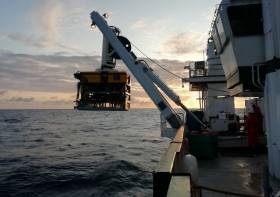
An Irish-led, international team of marine scientists on board the RV Celtic Explorer recently completed the third and final leg of an extensive offshore reef study using the Marine Institute’s remote operated vehicle (ROV) Holland 1.
The 21-day expedition investigating sensitive deep-sea habitats at the outer extent of the continental shelf off the southwest of Ireland was part of the SeaRover (Sensitive Ecosystem Assessment and ROV Exploration of Reef) project.
During their time at sea, the survey team mapped 154 separate locations within Ireland's marine territory, in what the Marine Institute describes as one of the most significant deep water benthic habitat assessments undertaken in this country.
The data and findings will contribute to good fisheries practice and the sustainable management of Ireland's marine biodiversity, the institute adds.
The survey used the ROV Holland 1 to capture high-definition footage of reef habitats up to 3000 metres deep, and to recover biological and sediment samples from 52 locations along the continental margin.
“Sensitive reef habitats form fragile ecosystems and attract a variety of marine species, such as sea pens, sponges, fish and crustaceans,” said survey chief scientist Yvonne Leahy, of the National Parks and Wildlife Service (NPWS).
“Surveying these habitats enables us to better understand Ireland’s deep sea territory so that we can protect and monitor our marine biodiversity and sustainably manage Ireland's marine resources effectively.”
Scientists from NUI Galway and University of Plymouth also joined the expedition to gather a range of biological samples to enable further research into population genetics studies, ecological modelling, and the harvesting of sponges for potential novel compounds for use in bio-medical applications.
Sediment samples will also be utilised for microplastics studies by NUI Galway and Galway-Mayo Institute of Technology (GMIT).
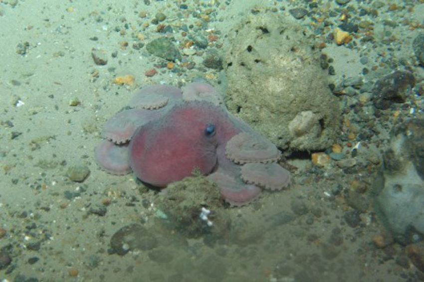 An octopus 1,000 metres below the surface | Photo: Marine Institute
The three SeaRover surveys between since 2017 have involved a combined 63 days at sea, recorded 332 hours of high-definition video from the seafloor — almost 14 days of footage — and have undertaken detailed studies of 350km of seabed along a shelf extent of nearly 2,500km.
The surveys have explored 154 different locations along Ireland’s continental margin, including the Rockall and Porcupine Banks, the Goban Spur and the Whittard Canyon.
The HD camera picks up fine detail of deep-water coral species. The first SeaRover survey in 2017 included the discovery of the deepest known occurrence of the cold-water coral Solenosmilia variabilis, forming reefs in Irish waters at depths of 1,600m.
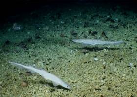
In 2018 the team discovered a rare shark nursery, 200 miles west of Ireland. A large number of egg cases were filmed on the seafloor at depths reaching 750m, and a large school of blackmouth catshark (Galeus melastomus) were present at the site. There were also numerous recordings of different coral species observed in Irish waters for the first time.
“After three years, the survey team has created an extensive data set which represents one of the most comprehensive assessments of Ireland's marine biodiversity,” said Leonie O'Dowd, Marine Institute section manager and European Maritime and Fisheries Fund (EMFF) programme co-ordinator.
“The success of these surveys is thanks to the coordination and collaboration across many organisations and government departments, and will benefit national policy development as well as researchers and scientists exploring our marine territory in the future.”
Thomas Furey, the Marine Institute’s joint INFOMAR programme manager, added: “It is fantastic to see the underlying INFOMAR seabed mapping data being used to strategically identify and target such vulnerable marine ecosystems for detailed studies in support of future marine management plans.
“In funding INFOMAR, the Department of Communications, Climate Action and Environment are supporting key evidence based investigations of our ever changing marine environment.”
The three-year SeaRover project was commissioned and jointly funded by the Irish Government and the EU’s European Maritime and Fisheries Fund (EMFF).
The cross-government initiative was supported by the Department of Agriculture, Food and Marine, Department of Culture, Heritage and Gaeltacht, and Department of Communications, Climate Action and Environment as part of the Marine Institute’s implementation of the EMFF Marine Biodiversity scheme.
Survey operations were led by the Marine Institute, INFOMAR and NPWS, accompanied by scientists from NUI Galway and the Marine Biology and Ecology Research Centre at the University of Plymouth, and supported by scientists in Geological Survey Ireland and the Norwegian Marine Institute.
Find Out More About Ireland’s Rare Shark Nursery At Galway Science and Technology Exhibition This Sunday
Members of the Marine Institute, INFOMAR and Explorers Education teams, as well as the chief scientist of the SeaRover survey, will be at the Galway Science and Technology Festival this Sunday (25 November) highlighting the recent discovery of a rare shark nursery in deep waters off the West of Ireland.
The shark-themed stand — All About Sharks, Sharks and More Sharks — will also provide children and their families an insight into the life of a marine scientist, what seabed mapping involves and how this led to the discovery of the shark nursery.
“It was incredible, real David Attenborough stuff,” David O'Sullivan, chief scientist for the SeaRover survey, told the Guardian. “This is a major biological find and a story of this magnitude would have been on Blue Planet if they'd known about it. Very, very little is known on a global scale about deep-sea shark nurseries.”
The SeaRover suvey, using the Marine Institute’s remotely operated vehicle (ROV) Holland 1 onboard the ILV Granuaile, took place during the summer 2018 off the Irish coast.
And its findings show the significance of documenting sensitive marine habitats, which will assist in a better understanding of the biology of these animals and their ecosystem function in Ireland’s Biologically Sensitive Area.
If you’re interested in learning more about the discovery of the sailfin sharks, you will find the experts at the back of the Bailey Allen Hall at NUI Galway from 10am to 6pm. Entry is free of charge and open to the public.
New Expedition Finds Deepest Ever Irish Corals
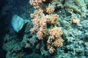
#MarineScience - A team of scientists have discovered the deepest known occurrence of a cold water coral reef known as Solenosmilia variabilis in Irish waters.
The marine scientists, led by the Marine Institute with the National Parks and Wildlife Service (NPWS), travelled over 1,000 nautical miles over three weeks along Ireland's Porcupine Bank and continental slope collecting HD video, sample cores and biological specimens from marine wildlife along the shelf edge from 50 locations.
They also explored the Atlantic Ocean to depths of more than 1,600 metres as part of a multi-agency and university collaboration using video mapping with the Marine Institute’s mini-submarine ROV Holland I.
The SeaRover survey was carried out on the Commissioner of Irish Lights vessel ILV Granuaile, gathering data for marine planning, habitat protection and measuring the effects of climate change.
“Some of the reef ecosystems and habitats we discovered have never been seen before, and discovering S. variabilis at depths greater than 1,600m helps us establish a better understanding of the environmental conditions necessary for this species to thrive,” said INFOMAR chief scientist David O’Sullivan.
"The deep-sea coral S. variabilis is widespread, normally seen at depths between 1,000 to 1,300m on seamounts or rocky areas deep under the sea but only occasionally forms reefs.
“Its growth rate is very slow approximately one millimetre per year, so finding the reef structure, which is part of a fragile ecosystem thousands of years old, in deeper parts of the ocean is an important find for marine science.”
Also found in this extreme deep sea environment were sea pens, which visually look like a cross between a feather, a starfish and a fern, but are are actually a form of soft coral.
“With over 300 species currently known around the world, they come in a variety of shapes, sizes and colours — we have seen a wide variety of forms on this survey, and can only give species names to very few as many are likely to be new to science and have yet to be described,” said Dr Yvonne Leahy of the NPWS.
“There are undoubtedly many more unidentified species out there and we ourselves have observed some specimens that require closer examination to properly identify.”
The team used the ROV Holland 1 to map the distribution and extent of deep water reefs and associated habitats, as well as using high-resolution bathymetric maps produced under the national seabed mapping programme INFOMAR, a joint initiative of the Marine Institute and the Geological Survey of Ireland.
The bathymetric data, which shows the depths of the ocean, has been key in identifying specific seabed features such as submarine canyons, escarpments and mounds where reef habitats are likely to occur.
The SeaRover (Sensitive Ecosystem Assessment and ROV Exploration of Reef Habitat) survey is jointly funded by the Government and the EU through the European Maritime Fisheries Fund and NPWS to undertake further mapping surveys of offshore reefs, with the aim of evaluating status and review requirements for conservation and management measures consistent with the Habitats Directive.
The project is co-managed by the INFOMAR programme and Fisheries Science and Ecosystem Services at the Marine Institute and NPWS. While the project objectives are primarily policy driven, the collection of data and scientific benefit will also be of immense benefit to the national and international research community.
The ROV robotic arms were also used to collect biological specimens for NUI Galway's SFI funded project ‘Exploiting and Conserving Deep Sea Genetic Resources’, and will also give new information on where sensitive species are found to help research at University of Plymouth’s Deep Sea Conservation Unit to predict where high value ecological areas might be identified offshore of Ireland and the wider North East Atlantic.
“The biological samples will help us understand the connectivity of different cold-water coral reef habitats, which will ultimately help with their future management,” said on-board senior scientist Dr Kerry Howell from Plymouth University.
This latest research mission comes less than two months after a team of university researchers and students on the RV Celtic Explorer explored cold water corals and sponges in the Whittard Canyon on the south-western edge of the continental shelf.


 Michael Murphy Schull Harbour Sailing Club (SHSC), Eric Coogan Heineken Ireland, Mark Murphy, Commodore SHSC, Jack Allen SHSC, Carmel O'Regan SHSC, Cornelious Ndlovu, Schull Harbour Hotel Operations Manager and Derval Murphy SHSC")

