


 for the new skiff and builder Patsy Whelan Jnr.")


Displaying items by tag: Marine Institute
Public Invited To Have Their Say On National Marine Planning Framework Report
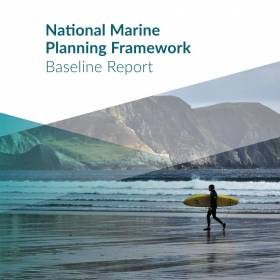
#OurOceanWealth - A new report aims to brings together a clear picture of all activity in Ireland’s seas for the first time.
Published yesterday (Tuesday 18 September), the National Marine Planning Framework Baseline Report has been branded “a key part of the process of developing Ireland’s first marine spatial plan”, which is intended to be the marine equivalent of the National Planning Framework.
The report sets out the context in which the marine plan is being developed in order to identify the key issues to address via consultation or discussion with various stakeholders, whose responses will inform the first draft framework to be published in mid 2019.
Representatives from all key sectors — fisheries, aquaculture, energy, tourism, sport, local authorities and environmental NGOs — comprise an advisory group overseeing the process.
Speaking on the Baseline Report, Damien English, Minister of State at the Department of Housing, Planning and Local Government with responsibility for marine planning, said: “When we see the demands being placed on our marine area clearly laid out, we can effectively consider whether those demands can be met simultaneously or whether some management or governance is required in particular areas.
“As we move further along the process of plan-making, the report, and your feedback on it, will play a critical part in the examining of potential synergies and co-existences, facilitating conflict resolution, anticipating future spatial needs and balancing the ecological, economic and social elements of the marine in a sustainable fashion.”
Developed with assistance from the Marine Institute, the report is available online and the public are invited to make submissions on it until noon on Friday 14 December.
A series of regional panel events discussing the report will be held shortly in Waterford (Tuesday 2 October), Galway (Friday 5 October), Sligo (Friday 12 October), Cork (Friday 19 October) and Dublin (Tuesday 23 October).
New Project To Uncover Secrets Of Ireland’s Offshore Ocean Floor
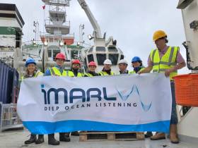
#MarineScience - Researchers from the Dublin Institute for Advances Studies (DIAS) departed Cobh yesterday (Monday 17 September) on the RV Celtic Explorer with a mission to monitor seismic activity on the North Atlantic Ocean floor.
As Silicon Republic reports, the SEA-SEIS project will deploy 18 seismometers over the next three weeks to form a network that will cover Ireland’s offshore area.
These sensors will collect data over the next two years, measuring tiny vibrations from seismic and ocean waves that will inform 3D models to unveil the mysteries below the sea bed.
DIAS is partnering with the Marine Institute, Geological Survey of Ireland, Science Foundation Ireland and Irish Centre for Research in Applied Geosciences (iCRAG) on the SEA-SEIS mission that will use acoustic sensors developed by the iMARL deep ocean listening project.
“The geological evolution of Ireland’s offshore territory is fascinating, but there is still so much of it to be explored,” said Prof Chris Bean, a specialist in geophysics at DIAS.
He added the SEA-SEIS project means that for the first time “we will be able to make long-term direct observations of the interactions between our oceans and solid Earth in this region.”
Silicon Republic has more on the story HERE.
Big Presence For INFOMAR At Major Seabed Mapping Conference
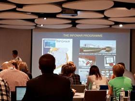
#MarineScience - The extensive work carried out jointly by the Marine Institute and Geological Survey Ireland through the INFOMAR programme received substantial exposure and recognition at the 16th Forum for the Exchange of Mutual Multibeam Experiences (FEMME) in Bordeaux last week.
Hosted by the Kongsberg Maritime User Forum and focussing on seabed mapping, FEMME provides an international platform for hydrographic professionals to meet, exchange experiences and ideas, provide inspiration and contribute to improved system performance and the future of underwater mapping technologies.
High-profile attendees include the secretary general of the International Hydrographic Organization (IHO), chief hydrographers from the Service Hydrographique et Océanographique de la Marine (SHOM), and Seabed 2030 leaders.
An overview of the Department of Communications, Climate Action and Environment-funded INFOMAR programme was provided by Dr Fabio Sacchetti, who updated the audience on future plans as well as recent achievements of the Irish national seabed mapping initiative.
Dr Sacchetti highlighted 10 case studies featuring multiple applications of multibeam technologies in support of sectors including coastal engineering, marine conservation and marine heritage and tourism.
In addition, a recent high-profile collaboration between INFOMAR and various US and Canadian research institutes was presented by international research partners in attendance.
INFOMAR featured prominently in a talk by Prof John Hughes Clarke (CCOM/University of New Hampshire) when describing research into the impact of internal wave activity on multibeam bathymetry in an Irish/Celtic Sea context, based on work conducted onboard the RV Celtic Explorer.
Prof Clarke has been collaborating with INFOMAR since 2015, and he is particularly focused on using hydrographic and fisheries sonar systems, combined with oceanographic data, to gain a deeper understanding of the dynamics and complexities of the Celtic Sea.
Jose Cordero, of Instituto Hidrografico dela Marina (Spain), demonstrated how improved sound speed control through remotely detecting thermocline undulations can be achieved.
The study was the result of a collaboration carried out in 2017 onboard the RV Celtic Explorer during a routine INFOMAR survey.
Finally, Anand D Hiroji (HSRC/University of Southern Mississippi) showed how unambiguous radiation pattern extraction methods can improve data derived from multisector multibeam Sonars. Once again, this study was carried out using data acquired by INFOMAR onboard the RV Celtic Explorer.
As Ireland continues toward completion of its seabed mapping programme in 2026, the Marine Institute says it is “widely acknowledged internationally” that our best practice approach towards open and integrated data acquisition, integration and exploitation “is a valued model, and one which gives Irish researchers and technology developers a global audience, and market.”
Try Out Angling At The National Ploughing Championships This Week

#Angling - Novice anglers are invited to try their hand at fishing at the upcoming National Ploughing Championships.
Inland Fisheries Ireland will attend the three days that kick off in Screggan near Tullamore, Co Offaly from tomorrow, Tuesday 18 September, with a fun fishing simulator suitable for all the family.
The simulator will be present at IFI stand within the Department of Communications, Climate Action and the Environment’s tent at the championships.
Fisheries officers will be on hand to answer questions from members of the public around best farming practice on waterways, and how to take up angling as a novice, as well to provide information and guidance around Ireland’s fish species and the aquatic environment.
There will also be aquariums with a range of coarse and game fish species on display.
“The participation of the public in the fisheries resource is vital in ensuring it is protected and enhanced in a sustainable manner for both the recreational and economic benefits it offers to communities nationwide,” says Suzanne Campion, IFI’s head of business development.
“We are looking forward to sharing insights into the fisheries resource, and the indigenous fish species that live within it, with both the general public and the farming community.”
Also exhibiting at the National Ploughing Championships this year are Leave No Trace Ireland and the Marine Institute’s Explorers Education Programme, who aim to highlight the impact of plastics in our oceans at their stand in the the Department of Community and Rural Affairs tent.
“A truckload of plastic waste finds its way into the ocean every minute of every day, and it is estimated that by 2050 there could be more plastic by weight than fish in the ocean unless behaviours change,” explains Maura Lyons, chief executive of Leave No Trace Ireland.
“Although we are all contributing to this worldwide epidemic, recent campaigns such as Say #No to Plastic have generated an amazing amount of supporters at community levels – particularly with children and families wanting to create change.”
With the research being completed in Ireland and around the world, results of plastics making their way into the ocean are showing a significant impact on the marine environment and animals.
Unprecedented levels of microscopic plastic particles were recently detected in an oceanic survey carried out by phytoplankton, biotoxin and oceanographic scientists from the Marine Institute.
From the larger plastics to clothes fibres from our washing machines all making their way into the ocean, visitors to the Leave No Trace/Explorers Education stand will get an opportunity to learn how long it takes for single-use plastic to break down, as well as receiving tips on how to go plastic free.
Those attending will also get to see live native marine species that are typically found in rock pools around the Irish coast including dogfish, plaice and starfish in the Explorers display boat.
“It is great to see an increased interest from children, schools, communities and businesses in Ireland that have already committed to reducing single-use plastics by offering alternatives for customers,” Lyons says. “These small changes can result in big impacts, which will help encourage a change in behaviours.”
‘Super Healing’ Limpets & Potentially Lifesaving Sea Sponges Among Recent Irish Marine Science Firsts
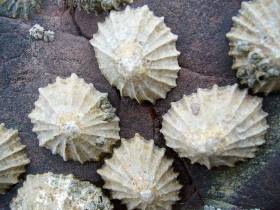
#MarineScience - Researchers at Trinity College Dublin have identified ‘super healing’ capabilities in limpets, as Trinity News reports.
The small molluscs, which can be found in coastal areas all around the world, were studied for a paper in the Journal of the Royal Society Interface.
Trinity scientists found that the limpets they studied were able to sense minor damage to their shells from weathering or predator attacks, and repair them much in the way mammals heal broken bones.
Meanwhile, sea sponges recently discovered in Ireland’s deep ocean territory could hold special medicinal properties, according to The Irish Times.
Samples taken during the recent Marine Institute expedition are being tested for their effectiveness in treating cancer, Parkinson’s disease, Huntington’s disease, epilepsy and other conditions.
The relevant chemicals are produced by the sponges as part of their defences against competing marine organisms, and NUI Galway’s Dr Louise Alcock hopes to see positive results within the next year.
World’s Most Advanced Ship For Monitoring Harmful Algae Completes Survey Of Irish Waters
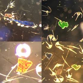
#MarineScience - Blooms of toxin-producing algae and unprecedented levels of microplastic particles were detected in a recent oceanic survey carried out by scientists from the Marine Institute.
Bristling with sensors and state-of-the-art technology, the German research vessel RS Heincke completed a circumnavigation of UK and Ireland this August in a month-long survey.
A team of six Irish phytoplankton, biotoxin and oceanographic scientists joined the survey, which was conducted by the Alfred Wegener Institute Helmholtz Centre for Polar and Marine Research in collaboration with the Marine Institute and the University of Oldenburg Institute for Chemistry and Biology of the Marine Environment.
A total of 75 stations were surveyed using instrumentation aboard the ship, which was primarily designed to investigate Azaspiracid toxins produced by a number of micro-planktonic species of the family Amphidomataceae.
“This research is important for us as Ireland remains the most affected country in the world by shellfish poisonings caused by toxins produced by these species,” said Joe Silke, senior scientist on the survey from the Marine Institute.
These toxins, which were first discovered 23 years ago during routine monitoring of Irish shellfish, have resulted in annual temporary closures of Irish shellfish production areas, with resulting economic loss from loss of sales and markets.
Recent research has identified that the Amphidomataceae, unlike many other toxic algae, are pelagic plankton found in the open sea to the west of Ireland. These can accumulate in specific cases of currents and wind direction, creating toxin problems in the shellfish production bays along the West coast.
This was the first time that near real-time analysis was possible underway due to the advanced equipment available for the survey, including a fully equipped chemistry lab capable of measuring and identifying trace levels of toxin produced by the plankton using a liquid chromatography mass spectrometry instrument. Only 30 minutes after taking plankton samples aboard a full characterisation of the toxins present was possible with this equipment.
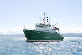
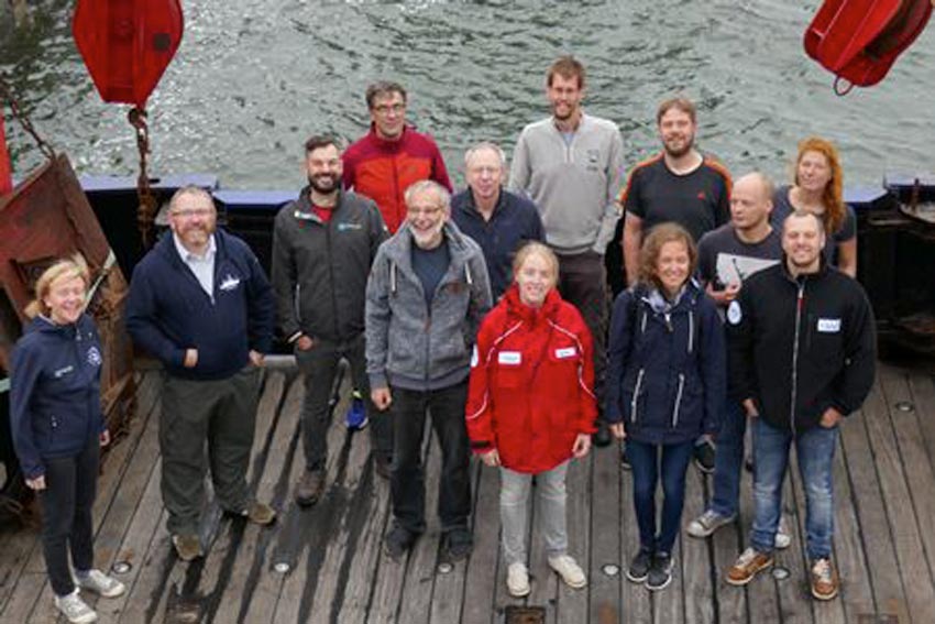 Irish and German scientists aboard the RS Heincke for the HE516 phytoplankton survey of the North Sea, English Channel and Atlantic Shelf | Photo: Marine Institute
The team of scientists on board were able to confirm the presence of these phytoplankton at several offshore and nearshore stations, and collected an integrated data set comprising oceanographic, bio-optical, meteorological, plankton and sediment data accompanied by taxonomic determinations, toxin measurements and DNA analysis.
“Having the capability to carry out near real-time analysis of microscopic plankton while at sea to reveal the species present and their toxins is a huge leap forward in opportunities for our research programmes,” Silke said.
Simultaneous research activities included taxonomic analyses of the filtered plankton. Scientists used high resolution microscopy, further supported by real-time analyses of the plankton using molecular biological technology designed to recognise the DNA fingerprint of individual species.
Automated instruments on board such as a FerryBox carried out physico-chemical analysis of underway water, and a Flow-Cam carried out automated particle measurements and image analysis of phytoplankton samples. Full bio-optical properties of the water were measured using instruments on the ship measuring spectral properties both above and in the water.
In the course of the survey, several other blooms of algae were detected along the oceanographic fronts traversed by the ship’s track. These included large blooms of the usual late summer phytoplankton that we commonly see in coastal waters. These comprised mostly diatoms and dinoflagellates, such as Dinophysis acuta that produce DSP shellfish toxins, and Karenia mikimotoi that can cause fish and invertebrate mortalities if it accumulates in coastal areas.
The survey also revealed several species of Azadinium, the target group for this survey. These included some rare species, and some that have not been recorded previously in Irish waters.
One unexpected observation in the plankton net hauls was the diverse and frequent observation of microplastic particles in the same size range as the phytoplankton. While the survey was not looking for these in particular, it was evident that their occurrence is more widespread than observed in previous surveys in offshore waters, and would also appear to be diverse in nature based on shape and colour.
The European Food Safety Authority stated recently that plastic particles of this nature are less likely to pass to humans through fish, because the they do not pass through the intestine into other tissues of finfish, and the digestive tract is normally discarded. They may, however, pass to the food chain through filter-feeding shellfish species where the GI tract is consumed.
The sizes of particles observed on this survey would lend support to this, although the risk of exposure to humans and its consequence on health requires more research.
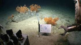
#MarineScience - A UCC-led group of scientists from across the globe have revealed a submarine canyon on the edge of Ireland’s continental shelf, 320km west of Dingle, after mapping an area twice the size of Malta.
The group returned last Friday (10 August) after a research expedition on board the Marine Institute’s RV Celtic Explorer with ROV Holland I, mapping 1,800 sqkm of seabed to image the upper canyon over a fortnight.
Scientists say the find is significant in understanding more about how submarine canyon helps transport carbon to the deep ocean.
Although there is excess CO2 in the atmosphere (the greenhouse effect), the ocean is absorbing this at the surface, and canyons pump this into the deep ocean where it cannot get back into the atmosphere.
The expedition, led by Dr Aaron Lim of UCC’s School of Biological, Earth and Environmental Sciences (BEES), utilised the Marine Institute’s remotely operated vehicle (ROV) Holland I and state-of-the-art mapping technologies to learn more about the nature of the canyon.
“This is a vast submarine canyon system, with near-vertical 700m cliff in places and going as deep as 3,000m. You could stack 10 Eiffel towers on top of each other in there,” Dr Lim said. “So far from land this canyon is a natural laboratory from which we feel the pulse of the changing Atlantic.”
According to Dr Lim, this discovery coupled with recent findings on the Irish-Atlantic margin – including rare sponge reefs and a spectacular mountain range in the mid-Atlantic – shows the advances in both Ireland’s marine technology and scientific workforce. “Ireland is world-class, and for a small country we punch above our weight,” he said.
The Porcupine Bank Canyon is the westernmost submarine canyon on the contiguous Irish margin 320km west of Dingle and exits onto the abyssal plain at 4,000m water depth. The upper canyon is full of cold-water corals forming reefs and mounds which create a rim on the lip of the canyon 30m tall and 28 km long.
The coral reefs on the rim of the canyon eventually break off and slide down into the canyon, where they form an accumulation of coral rubble deeper within the canyon.
The ROV ventured deeper into the canyon and found significant build-ups of coral debris that have fallen from hundreds of meters above.
“This is all about transporting carbon stored cold water corals into the deep. The corals get their carbon from dead plankton raining down from the ocean surface so ultimately from our atmosphere,” said Prof Andy Wheeler of the School of BEES at UCC and the Irish Centre for Research in Applied Geosciences (iCRAG).
“Increasing CO2 concentrations in our atmosphere are causing our extreme weather; oceans absorb this CO2 and canyons are a rapid route for pumping it into the deep ocean where it is safely stored away.”
The new detailed maps show lobes of sediment debris and the scars from submarine slides as the canyon walls collapse. There is also exposure of old crustal bedrock and incised channels in the canyon floor carved by sediment avalanches.
“We took cores with the ROV Holland I and the sediments reveal that although the canyon is quiet now, periodically it is a violent place where the seabed gets ripped up and eroded,” Prof Wheeler added.
The new mapping data shows a rim feature along the lip of the canyon at approximately 600m water depth.
“When we sent down the ROV, we saw that this rim is made of a profusion of cold water corals, which appears to extend for miles along the edge of the canyon,” said Prof Luis Conti of the University of Sao Paulo, Brazil.
The research supports the shared vision of the Atlantic Ocean Research Alliance, which includes the ongoing cooperation on ocean science and observation in the Atlantic Ocean.
The research has been funded by Science Foundation Ireland, Geological Survey Ireland and contributes to projects in the iCRAG. This research survey was also carried out with the support of the Marine Institute, funded under the Marine Research Programme 2014-2020 by the Irish Government.
Prof Wheeler’s Marine Geology Research Group in the UCC School of BEES is undertaking a research project to monitor the range of coral habitats within this canyon with the aim of understanding what drives these habitats, how they change through time and how sensitive they are to disturbances.
‘Bob The Buoy’ Retires Ashore To Valentia Island
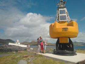
#Buoys - After more than two decades of service as part of the Marine Institute’s national weather buoy network, the affectionately named ‘Bob the Buoy’ will see out his retirement as a permanent resident at Valentia Lighthouse.
Bob withstood countless storms over the years, reporting hourly weather observations to Met Éireann and European partners.
Now visitors to Valentia Island in Co Kerry can check out Bob’s new home at Cromwell Point and get a closer insight into Ireland’s marine navigation and safeguarding history.
“Weather buoys are a fundamental aspect of our maritime history, and it is our hope that Bob will emphasise this in his new location here, on Valentia, the most extreme south-westerly point of Europe,” said Paul Duff, member of the lighthouse committee which worked closely with the Marine Institute on the buoy’s relocation.
“It is fitting that he should be placed here, and we look forward to incorporating him into our visitor experience,” Duff added.
Lighthouse committee chair Brian Morgan said: “This is such a fantastic artefact. It is our hope that we can reinstate Bob, a working retirement if you like, in order for us to provide a weather feed which we can share through our community, and lighthouse network, utilising the available technology, but we will let him settle in first.”
Dr Guy Westbrook from the Marine Institute said he and his colleagues are delighted that Bob has a new home at Valentia to educate the public about the weather buoy network.
“Designed to improve weather forecasts and safety at sea around Ireland, the buoy network provides vital data for weather forecasts, shipping bulletins, gale and swell warnings as well as data for general public information and research,” Dr Westbrook added.
In other news, the large marker buoy found adrift by Clifden RNLI in late July has been removed from the Connemara coast.
Harry Duggan of the Commissioners of Irish Lights says the buoy, which originated in Canadian waters, was as of yesterday (Friday 10 August) on its way to CIL headquarters in Dun Laoghaire.
The CIL recommends caution around any and all aids to navigation around the Irish coast.
Shiptime Charter Applications For 2019 & 2020 Now Open
#MarineScience - Applications are open for shiptime in 2019 and 2020 on Ireland’s national research vessels Celtic Explorer and Celtic Voyager, as well as the ROV Holland I and the Laochra na Mara glider.
Every year a broad range of organisations use the Marine Institute’s vessels for research, development and monitoring programmes. These include Government departments and agencies, universities, research institutes and industry.
Applications for shiptime for 2019 and 2020 must be submitted using Research Vessel Operations’ online Survey Planning System (SPS) by Thursday 20 September. Please contact Research Vessel Operations to obtain an SPS login if you don’t already have one and to inquire about glider availability.
Each application will be reviewed and the applicant will be informed as soon as possible whether the shiptime they requested is available. If the requested shiptime is not available, alternative dates may be offered. The Vessel Charter Guidelines should be read carefully before submitting the ship time application form.
Applicants may seek grant aid to cover all or part of the vessel charter costs for research surveys or ship-based Training Programmes. The closing date for receipt of grant aid applications is 5pm on Friday 21 September.
Applicants for ship-based training are advised to consult with the Strategic Marine Alliance for Research and Training (SMART) at [email protected].
The survey schedules can change during the year, therefore please contact Research Vessel Operations to check whether any survey slots remain for 2018 or to be notified if any dates become available.

#OurOceanWealth - New research from NUI Galway’s Socio-Economic Marine Research Unit (SEMRU) focuses on the ecosystem service benefits that society receives from Ireland’s marine environment.
The latest bi-annual report — Valuing Ireland’s Marine Ecosystem Services — was launched at the recent fifth annual Our Ocean Wealth Summit in Galway by Damien English, Minister of State for Housing and Urban Development, and Seán Kyne, Minister of State for Natural Resources, Community Affairs, and Digital Development.
Marine ecosystem services are provided by the processes, functions and structure of the marine environment that directly or indirectly contribute to societal welfare, health and economic activities. These services are vital to ensuring blue growth in Ireland’s ocean economy, which was valued at €1.8 billion or approximately 1% of gross domestic product (GDP) in 2017.
Factoring marine ecosystem service values into ocean economy account frameworks may help to ensure a sustainable ‘blue economy’ for Ireland by making sure that growth in the ocean economy does not exceed the carrying capacity of the marine environment.
While the value of some of these goods, such as fishing and aquaculture, are somewhat easier to measure, the value of many other benefits — such as carbon sequestration, waste assimilation and marine-related recreation — are often not captured by a price in any established markets.
However, without incorporating these values into marine planning processes, these benefits may be ignored or underestimated leading perhaps to suboptimal decision making.
Marine Institute chief executive Dr Peter Heffernan welcomed the new report, commenting: “This assessment of Ireland’s marine ecosystem services and their value is an important step in incorporating ecosystem services into policy and decision making related to Ireland's marine and coastal zones.”
SEMRU director Dr Stephen Hynes added: “Blue growth is about fostering development in marine economic activities in such a manner that the long term ability of the marine environment to continue to provide ecosystem service benefits is not compromised.
“This is exactly what Harnessing Our Ocean Wealth: An Integrated Marine Plan for Ireland is aimed at achieving. Knowing what those benefits are and what they are worth is vital for deciding on the best use of our marine resources and to ensure blue growth for our ocean economy far into the future.”
Commenting on the significance of the report, Dr Micheál Ó Cinnéide, director of the office of communications and corporate services at the Environmental Protection Agency (EPA), said it “adds greatly to our understanding of the value of our marine province. Anybody who was able to see the marvellous RTÉ documentary on Ireland’s Deep Atlantic in 2018 and who follows the pioneering work of researchers in the Marine Institute, Galway and Cork can appreciate that we are unlocking the treasures of our offshore world.
“As this report shows, the true value has to include the natural capital, economic potential, cultural and spiritual values. The EPA and the Irish Forum on Natural Capital looks forward to a wider national debate on safeguarding this priceless marine ecosystem for future generations.”
Valuing Ireland’s Marine Ecosystem Services is based upon research supported by the EPA and is based on previous research conducted under the Marine Institute’s Beaufort Award.
The full report is available to download from NUI Galway, with the technical version on the EPA website.
Summary of economic contribution of marine ecosystem services:
- The provisioning marine ecosystem services of fisheries and aquaculture is estimated to be worth €473 million per annum to all fleets and producers operating in Irish waters.
- Seaweed harvesting is valued at €4 million and aquaculture at €150 million.
- The regulating and maintenance ecosystem services of carbon sequestration are valued at €815 million per annum, waste assimilation services €317 million and coastal defence services of €11.5 million.
- The cultural ecosystem services of scientific and educational services are valued at €11.5 million, and the added value per annum to housing stock of being at the coast (aesthetic services) is valued at €68 million. On an annual basis, recreational services provided by the marine ecosystems are estimated to have an economic value of €1.7 billion.
- Even though not all of the ecosystem services provided by the marine environment can be monetarised, the report indicates that the value of those that can is substantial.


 Heat will move into the A/B Semifinals on Monday")

: Charlie Ward, Aoife O’Donnell, Ian Harford, Anna O’Leary and Liam Britchfield")


