Menu

Ireland's sailing, boating & maritime magazine

Inland afloat headers


Displaying items by tag: Climate Change

The 2022 EIFAAC Symposium will be hosted by Inland Fisheries Ireland and the Department of the Environment, Climate and Communications at Randles Hotel in Killarney on 20-21 June.

The rubric for the 31st symposium of the European Inland Fisheries and Aquaculture Advisory Commission — the first since Dresden, Germany in September 2019 — is ‘Advances in Technology, Stock Assessment and Citizen Science in an Era of Climate Change’.

Four themes have been identified for the symposium relating to inland fish stock assessment, developments in freshwater fish monitoring technologies, assessing the impacts of climate change on freshwater fish and their habitats and the role of citizen science. The fifth theme will focus on the pros and cons of traditional vs recirculation aquaculture systems.

Abstract submission is open for presenters until this Friday 18 February. Notification of acceptance letters all be sent on 25 March and presenting authors will have until 28 March to register. The deadline for submission of manuscripts/presentations is 13 June, one week before the symposium.

For those wishing to attend, early-bird registration is now open at €120 (students €80) until 1 April. Payment made after this date will incur an extra administration charge of €20.

For more details on attending the conference, see the IFI website HERE.

Published in Aquaculture

In Co Wexford, a seven-year-old boy has joined the grassroots effort to conserve vulnerable seagrass beds around Ireland’s coastline.

According to RTÉ News, Shem Berry has lent a helping hand to volunteers who have been clearing an invasive seaweed, Sargassum muticum, which smothers a seagrass meadow at Kilmore Quay.

Seagrass meadows are considered key ‘blue carbon’ habitats, acting as a natural carbon-capture store while also filtering sediments, keeping shorelines stable and providing a safe home for inshore marine wildlife.

“I think it’s important to look after the environment, not only on land, but on the sea,” said Shem.

As previously reported on Afloat.ie, environmental NGO Coastwatch has called for seagrass habitats to be specified for protection under the State’s new marine planning legislation.

RTÉ News has more on the story HERE.

Published in Coastal Notes

Space agencies in Europe and the US have signed a partnership to monitor rising sea levels and temperatures, melting ice, thawing permafrost and other impacts of climate breakdown.

NASA in the US and the European Space Agency (ESA) formalised the partnership this week with a “statement of intent”.

The agreement signed by ESA director-general Josef Aschbacher and NASA administrator Bill Nelson aims to “pave the way to leading a global response to climate change”, the organisations state.

“Climate change is an all-hands-on-deck, global challenge that requires action – now,” Nelson said.

“NASA and ESA are leading the way in space, building an unprecedented strategic partnership in Earth science,” he said.

“ This agreement will set the standard for future international collaboration, providing the information that is so essential for tackling the challenges posed by climate change and helping to answer and address the most pressing questions in Earth science for the benefit of the US, Europe, and the world,” he added.

This is not the first time ESA and NASA have joined forces – both bodies worked together on field campaigns in the Arctic to validate respective missions.

The two agencies also work together and with other partners on the recently launched Copernicus Sentinel-6 mission, a new project to extend the long-term record of sea-level rise.

In May, NASA announced its Earth System Observatory, which will design a new set of Earth-focused missions to provide key information to guide efforts related to climate change, disaster mitigation, fighting forest fires, and improving real-time agricultural processes.

This week’s joint statement of intent “complements activities underway for the Earth System Observatory”, they state.

Both ESA and NASA are currently defining a new gravity mission to shed new light on essential processes of the Earth system, such as the water cycle.

This will ‘weigh’ water in its various locations, such as underground and in the oceans, to understand water mass distribution and transport, they explain.

Josef Aschbacher said that “without doubt, space is the best vantage point to measure and monitor climate change, but joining forces is also key to tackling this global issue”.

“Timing is also important, particularly as we look to the COP26 climate conference later this year, where we have the chance to further make space an integral part of the solution when it comes to climate-change mitigation,” he said.

Published in Marine Science
Tagged under

This month the Marine Institute will launch a funding call for a major programme of marine science research in the area of ‘blue carbon’.

The absorption and storage of atmospheric carbon dioxide in the world’s oceans and coastal regions has been identified as one of the ways in which marine ecosystems can reduce the impacts of climate change.

Funding of up to €1.6m has been earmarked for the call to support a large-scale research project to run from 2021 to 2026.

Launched in June 2020, Ireland’s Programme for Government recognised the “the enormous blue carbon potential that the ocean has to offer in tackling climate change”.

Collaborative research initiative

The Government tasked the Marine Institute — the State agency responsible for marine research and innovation — with a collaborative research initiative, aimed at investigating the climate-change mitigation potential of blue carbon and working towards creating an inventory that will assist the EU in meeting Ireland’s climate-change objectives.

In order to prepare the ground for such a large-scale research programme, the Marine Institute commissioned a synthesis report to review existing knowledge on blue carbon habitats and their role as carbon sinks in Ireland. This report was published in May 2021.

“Blue carbon refers to carbon which is stored, or sequestered, in the ocean and in vegetated habitats around coastal regions,” explains the report’s lead author Dr Grace Cott, assistant professor at the UCD School of Biology and Environmental Science.

“In terms of blue carbon which we can actively manage, what we are really referring to is the vegetation in coastal regions, and that means three main habitats: firstly, mangrove forests — which we don’t have in Ireland and are mostly found in tropical regions — secondly, salt-marsh habitats and finally, seagrass meadows.”

From photosynthesis to sediment trapping

Carbon sequestration — the long-term capture and storage of carbon dioxide (CO2) from the atmosphere – can take place through a range of natural processes, from photosynthesis to sediment trapping, where carbon-based sediments from the tide are physically trapped by vegetation.

The Marine Institute report points out that Ireland’s tidally influenced coastal wetlands comprise approximately 160 square kilometres of salt-marsh and seagrass beds. Globally, although these habitats represent a much smaller area than terrestrial forests, their total contribution to long-term carbon storage is comparable to carbon sinks in tropical forests.

According to Dr Cott, salt marshes in Ireland are up to 10 times more efficient than agricultural grasslands at storing carbon on a per area basis. This is mainly due to the lack of microbial decomposition in these wet regions, which inland causes the release of carbon from the soil as carbon dioxide.

Supporting blue carbon into the future

The loss and destruction of vegetated coastal ecosystems threatens their ability to function as long-term carbon sinks, and mismanagement can lead to the release of stored carbon back into the atmosphere, says Dr Cott.

“But there is hope in the management of these resources,” she explains. “Even though researchers need to conduct further research into the matter, we are already becoming aware of certain strategies which can help preserve our blue carbon habitats around the Irish coast.”

These include allowing salt mash habitats to migrate inland, and improving water quality to optimise carbon capture in seagrass beds.

“Looking ahead, I believe that Ireland will need an appropriate management framework, led by Government, to enhance protection of these habitats in relation to carbon sequestration,” Dr Cott adds.

Published in Marine Science

European Commission president Ursula Von Der Leyen will be among the speakers at a high-level summit hosted by the organisers of The Ocean Race Europe next month.

The Ocean Race Summit Europe on Wednesday 16 June aims to help drive new and improved policies to tackle some of the most urgent issues facing our blue planet — from the impact of climate change to the lack of governance and protection for our sea and whether the ocean should be given ‘rights’.

Von Der Leyen and Brussels colleague Virginijus Sinkevičius, European Commissioner for Environment, Ocean and Fisheries will virtually join a diverse group of speakers and exclusively invited participants from across the world — comprising leading experts from the worlds of government, science, industry, NGOs, media and sport.

Among them are Mumta Ito, lawyer and Founder of the NGO Nature’s Rights, who will reveal why giving the ocean rights could help to ensure its future, and Tommy E Remengesau, former president of the Republic of Palau, who will discuss leading the way in ocean protection.

Alongside these leading voices will be the unique perspectives of sailors, who have unrivalled experiences of the ocean. Annie Lush from Offshore Team Germany will reveal what life is like on the high seas and how offshore racers are helping scientists understand climate and weather systems.

Other confirmed speakers include:

  • Pascal Lamy, president of the Paris Peace Forum and chair of the EU Mission Starfish 2030, talking on the ambitious mission to revamp ocean governance;
  • Dr Emily Pidgeon, vice president of Ocean Science and Innovation, talking about the importance of including the ocean in the climate conversation;
  • Teresa Ribera, Fourth Deputy Vice President and Minister for Ecological Transition for Spain, on the need to protect 30% of the ocean by 2030;
  • Valerie Cabanes, international law expert and co-founder of End Ecocide on Earth, who will reveal what ecocide means for people and nature; and
  • Manu San Felix, marine biologist from Ibiza Preservation and a specialist in the protection of posidonia (seagrass), who will highlight how the ocean can be a hero in the climate crisis.

The Ocean Race Summit in Newport, Rhode Island gathered over 680 registered participants from around the world | Credit: Ainhoa Sanchez/The Ocean RaceThe Ocean Race Summit in Newport, Rhode Island gathered over 680 registered participants from around the world | Credit: Ainhoa Sanchez/The Ocean Race

Hosted by renowned television presenter and science communicator Danni Washington, the event will also be held virtually — featuring local speakers live from The Ocean Race’s home city of Alicante in Spain with a live link to Brussels.

Richard Brisius, race chairman of The Ocean Race, said: “We have one ocean, but the way it is protected and governed is splintered. When you add to this the impact of climate change, it is a recipe for disaster for our marine world. We urgently need to create a better system, with collaboration at the heart of it.

“Sailors in The Ocean Race have seen more of the ocean, and its decline, than most people on the planet. Our Race is all about teamwork, overcoming challenges and achieving the extraordinary.

“We can apply this through our summits, to help drive change for the ocean. Sport has the power to make a real difference for the planet and we are going to do all we can to make the most of this opportunity.”

The summit will be live-streamed on The Ocean Race: Racing with Purpose YouTube channel and takes place during The Ocean Race Europe, which starts on 29 May in Lorient, France and finishes in Genoa, Italy with a coastal race on 19 June.

Published in Ocean Race

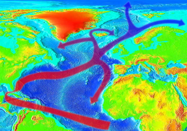
Ireland is represented in an international team of researchers who have identified a possible link between human-caused climate change and a weakening of the Gulf Stream.

And as The Irish Times reports, a continued weakening of the Atlantic Ocean current system could mean more extreme weather for Ireland — and an end to our typically mild climate.

The researchers’ study, published in journal Nature Geoscience, used a variety of sources to plot the history of the flow of the Gulf Stream: the Atlantic Ocean current that pulls warm water from the equator north while pushing colder water south and, via its extension as the North Atlantic Drift, gives Ireland and the UK our mild, wet weather.

Maynooth University’s Dr Levke Caesar, lead author on the study, said the team combined three different types of data — including deep-sea sediment samples dating back many centuries — to reveal “a robust picture of the overturning circulation” in the Atlantic.

It’s this picture that’s a worrying one for climate scientists, as it shows a distinct weakening of the Gulf Stream’s flow since the mid 20th century, and a trend that suggests it could reach a tipping point by the end of this century.

The Irish Times has more on the story HERE.

Published in Weather

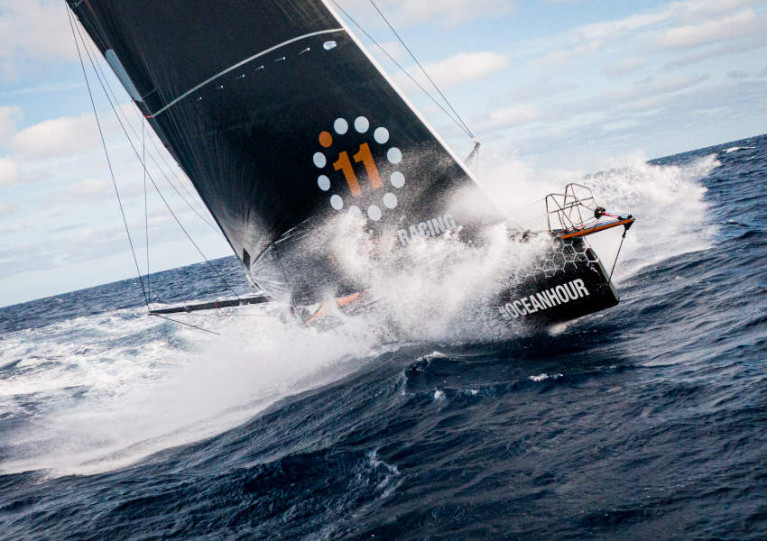
The 2022-23 edition of The Ocean Race is set to mark a sea change in its commitment to the environment by expanding the gathering of scientific data across the fleet.

On a recent transatlantic crossing by 11th Hour Racing Team — captained by Cork sailor James O’Mahony, with race veteran Damian Foxall as sustainability programme manager — high-quality oceanographic data was relayed ashore in real-time to improve models and predictions on ocean health and climate.

During the August voyage the boat’s crew used an onboard OceanPack — a device which records essential ocean data including surface temperature, salinity and dissolved CO2 — to sample seawater on a continuous basis and transmit the data live, rather than on arrival in port as in the last edition of the race.

The crew aboard the IMOCA 60 racing yacht also deployed a Drifter Buoy on the passage from France to Rhode Island in a target area where there is a gap in buoy coverage, for long-term real-time monitoring of ocean conditions.

“We want to build on the amazing success of our award-winning Sustainability Programme during the 2017-18 edition, which led the way in terms of offshore ocean data collection by a sailing event,” said Anne-Cécile Turner, The Ocean Race’s sustainability director.

“Everything we are doing under our new Racing with Purpose initiative, which has been developed in collaboration with 11th Hour Racing — our founding sustainability partner as well as the premier partner of the race — is aimed at taking that legacy and accelerating action to improve ocean health.”

She added: “The new and pioneering scientific equipment, now 30% lighter and 20% more energy efficient, is yet another example of the innovative record of onboard instrumentation.

“And, paired with the fact that teams on The Ocean Race go deep into some of the most remote areas on the planet like the Southern Ocean, it means that we are again in a unique position to contribute, this time to gather real-time scientific data to help inform decision making.”

Published in Ocean Race

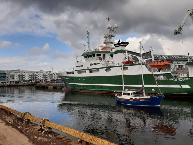
Scientists led by an Irish team on board the Marine Institute’s RV Celtic Explorer (returned yesterday) to the Port of Galway, after 24 days in the Nordic and Greenland Seas to investigate past climate change in the Arctic region.

Scientists involved, reports GalwayBay FM, were from NUI Galway, University of Southampton UK, University of Bremen, Germany, and Bergen University Norway, have been monitoring and capturing a record of temperature, salinity and the carbonate system

Lead scientist, Dr Audrey Morley, School of Geography and Archaeology, NUI Galway says their research is unique, as they are assessing how essential climate variables have evolved since before pre-industrial conditions.

The survey aims to define a more comprehensive description of the Nordic Seas ecosystem and provide insight into how essential climate variables are recorded in geologic archives.

Click here for more on the story and also the survey which examined the past to assist in understanding the future of climate change. 

Published in Marine Science

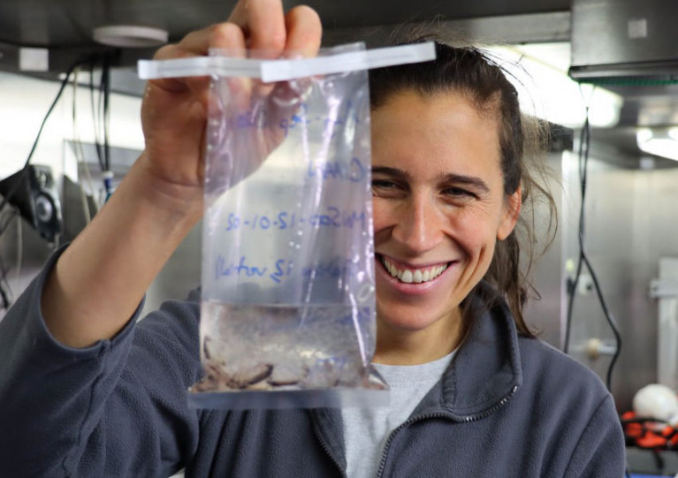
An Irish-led team of marine scientists on board the RV Celtic Explorer returns to Galway Harbour today (Wednesday 16 September) after more than three weeks investigating historic climate change in the Arctic region.

Scientists from NUI Galway, University of Southampton, University of Bremen and Bergen University had been capturing data in the Nordic and Greenland Seas as part of the CIAAN survey (Constraining the Impact of Arctic Amplification in the Nordic Sea: A biogeochemical approach).

This survey aims to provide new insight into how essential climate variables are recorded in geologic archives.

Assessing the impact and magnitude of past (pre-industrial) climate changes is critical to further our understanding of how the climate system will respond to a rapidly changing Arctic ecosystem, the scientists explain.

‘One of the key challenges in climate change science is assessing the magnitude of future climate change’

Lead scientist Dr Audrey Morley, from the School of Geography and Archaeology at NUI Galway, says: “One of the key challenges in climate change science is assessing the magnitude of future climate change, due to our short observational records which are limited to the past 150 years.

“Our research is unique, as we are not only observing modern essential climate variables, but we will also look into the past to assess how essential climate variables have evolved since before pre-industrial conditions.

“This long-term perspective is crucial and will help us to better understand our environment and the environmental consequences of human activities.”

Dr Morley notes that the Arctic is an especially sensitive and vulnerable environment with regards to contemporary climate change.

“The North Atlantic and Nordic Seas are a key region for the formation of North Atlantic deepwater and the uptake of atmospheric carbon dioxide. Whether or not this region will remain a carbon sink during rapidly warming climates is a question that remains to be answered,” she says.

As part of this research survey, the RV Celtic Explorer travelled to 79 degrees north in the Greenland Sea, which is the highest latitude reached by the marine research vessel.

‘The RV Celtic Explorer is crucial to facilitate this type of international research’

In order to operate in the Arctic region, the RV Celtic Explorer was required to obtain a Polar Code Certification — becoming the first Irish vessel to achieve this status, which greatly increases its ocean research capabilities.

“The RV Celtic Explorer is crucial to facilitate this type of international research,” says Marine Institute chief executive Dr Paul Connolly.

“This research in the Arctic region will deepen our knowledge of the region and will improve models that can forecast changes to our oceans and climate. This will inform effective policy and management decisions to meet the challenges posed by climate change.”
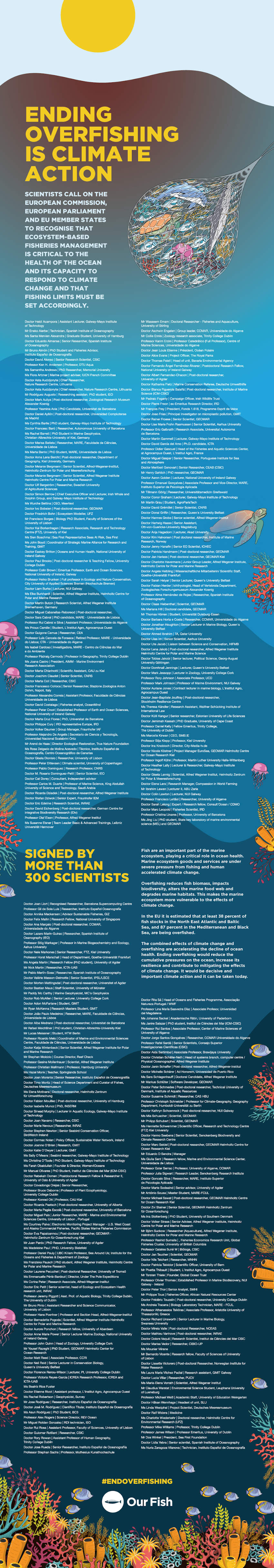
Published in Marine Science

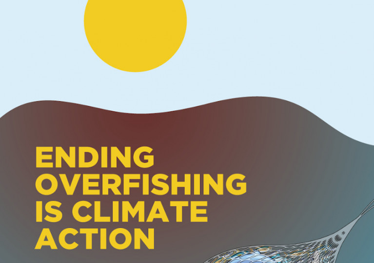
Scientists from GMIT, NUI Galway, UCD, Trinity College, UCC and Queen’s in Belfast are among the signatories to a statement calling for an end to overfishing in European waters “as an urgent and necessary response to the biodiversity and climate crises”.

The message was delivered to EU Commissioner for the Environment, Oceans and Fisheries, Virginijus Sinkevičius this week as part of a statement signed by more than 300 scientists in support of the Our Fish campaign.

These experts urge the EU to set fishing limits within scientific advice and recognise that “ecosystem-based fisheries management is critical to the health of the ocean and its capacity to respond to climate change”.

“Overfishing and bycatch are the largest drivers of biodiversity loss in the ocean”, said Prof Alex Rogers, science director for research initiative REV Ocean. “We need a healthy and productive ocean, and ending overfishing is key.

“This is especially the case when faced with the effects of climate disruption, which affects the whole ocean, including fish stocks themselves.

“As a scientist, I am calling on the EU to recognise that ecosystem-based fisheries management is critical to the health of the ocean and its capacity to respond to climate change. It is also vital for human health, including that of future generations”.

Rebecca Hubbard, programme director of Our Fish, added: “Just like with our own health, if we continue to batter the ocean with overfishing, the whole system will weaken further, until it can no longer provide us with the life-support we need it for — oxygen, climate regulation, food and jobs.

“The EU must stop dragging its feet and take this clear and decisive action now, before it’s too late.”

The statement and its signatories can be read below:

Our Fish statement and signatories

Published in Fishing
Page 3 of 8

General Information on using Waterways Ireland inland navigations

Safety on the Water

All users of the navigations are strongly recommended to make themselves aware of safety on the water for whatever activity they are involved in and to read the advice offered by the various governing bodies and by:

The Dept. of Transport, Ireland: www.gov.ie/transport and The Maritime and Coastguard Agency, UK, The RNLI – Water Safety Ireland for information in terms of drowning prevention and water safety.

Registration of Vessels

All vessels using the Shannon Navigation, which includes the Shannon-Erne Waterways and the Erne System must be registered with Waterways Ireland. Only open undecked boats with an engine of 15 horsepower or less on the Shannon Navigation, and vessels of 10 horsepower or less on the Erne System, are exempt. Registration is free of charge.

Craft registration should be completed online at: https://www.waterwaysireland.org/online-services/craft-registration

Permits for use of the Grand and Royal Canals and the Barrow Navigation

All vessels using the Grand and Royal Canals and the Barrow Navigation must display appropriate valid Permit(s) i.e A Combined Mooring and Passage Permit (€126) and if not intending to move every five days, an Extended Mooring Permit (€152).

Permit applications should be completed online at: https://www.waterwaysireland.org/online-services/canal-permits

Passage on the Royal and Grand Canals – Dublin Area

For boat passage through the locks east of Lock 12 into / out of Dublin on either the Royal or Grand Canals, Masters are requested to contact the Waterways Ireland Eastern Regional Office (M-F 9.30am-4.30pm) on tel: +353(0)1 868 0148 or email [email protected] prior to making passage in order to plan the necessary lock-keeping assistance arrangements.

On the Grand Canal a minimum of two days notice prior to the planned passage should be given, masters should note that with the exception of pre-arranged events, a maximum of 2 boats per day will be taken through the locks, travelling either east or west.

Movements in or out of the city will be organised by prior arrangement to take place as a single movement in one day. Boaters will be facilitated to travel the system if their passage is considered to be safe by Waterways Ireland and they have the valid permit(s) for mooring and passage.

Newcomen Lifting Bridge

On the Royal Canal two weeks’ notice of bridge passage (Newcomen Lifting Bridge) is required for the pre-set lift date, and lock assistance will then also be arranged. A minimum of 2 boats is required for a bridge lift to go ahead.

Waterways Ireland Eastern Regional Office (Tel: +353(0)1 868 0148 or [email protected] ) is the point of contact for the bridge lift.

A maximum number of boats passing will be implemented to keep to the times given above for the planned lifts (16 for the Sat / Sun lifts & 8 for the weekday lifts). Priority will be given on a first come first served basis.

On day of lift, boaters and passengers must follow guidance from Waterways Ireland staff about sequence of passage under bridge & through Lock 1, and must remain within signed and designated areas.

Events Held on the Waterways

All organised events taking place on the waterways must have the prior approval of Waterways Ireland. This is a twelve week process and application forms must be accompanied with the appropriate insurance, signed indemnity and risk assessment. The application should be completed on the Waterways Ireland events page at :

https://www.waterwaysireland.org/online-services/event-approval

Time Limits on Mooring in Public Harbours

On the Shannon Navigation and the Shannon-Erne Waterway craft may berth in public harbours for five consecutive days or a total of seven days in any one month.

On the Erne System, revised Bye Laws state that: No master or owner shall permit a vessel, boat or any floating or sunken object to remain moored at or in the vicinity of any public mooring, including mooring at any other public mooring within 3 kilometres of that location, for more than 3 consecutive days and shall not moor at that same mooring or any other public mooring within 3 kilometres of that location within the following 3 consecutive days without prior permission by an authorised official.

Winter Mooring on the Shannon Navigation and Shannon Erne Waterway

Winter mooring may be availed of by owners during the period 1 Nov to 31 Mar by prior arrangement and payment of a charge of €63.50 per craft. Craft not availing of Winter Mooring must continue to comply with the “5 Day Rule”. Winter Mooring applications should be completed online at : https://www.waterwaysireland.org/online-services/winter-moorings-booking

Owners should be aware that electricity supply and water supply to public moorings is disconnected for the winter months. This is to protect against frost damage, to reduce running costs and to minimise maintenance requirements during the winter months.

Vessel owners are advised that advance purchasing of electricity on the power bollards leading up to the disconnection date should be minimal. Electricity credit existing on the bollards will not be recoverable after the winter decommissioning date. Both services will be reinstated prior to the commencement of the next boating season.

Smart Cards

Waterways Ireland smart cards are used to operate locks on the Shannon Erne Waterway, to access the service blocks, to use the pump-outs along the navigations, to avail of electrical power at Waterways Ireland jetties.

Berthing in Public Harbours

Masters are reminded of the following:

  • Equip their vessel with mooring lines of appropriate length and strength and only secure their craft to mooring bollards and cleats provided for this purpose.
  • Ensure the available berth is suitable to the length of your vessel, do not overhang the mooring especially on finger moorings on floating pontoon moorings.
  • Ensure mooring lines, electric cables and fresh water hoses do not create a trip hazard on public jetties for others users.
  • Carry sufficient fenders to prevent damage to your own vessel, other vessels and WI property.
  • Allow sufficient space between your vessel and the vessel ahead /astern (c.1m) for fire safety purposes and /or to recover somebody from the water.
  • Do not berth more than two vessels side by side and ensure there is safe access/egress at all times between vessels and onto the harbour itself.
  • Do not berth in such a way to prevent use of harbour safety ladders, slipways or pump-outs.
  • Do not allow the bow of your vessel to overhang the walkway of a floating mooring thus creating a hazard for others with an overhanging anchor or bow fendering.
  • Animals are not allowed to be loose or stray at any time.
  • Harbour and jetty infrastructure such as railings, power pedestals, fresh water taps, electric light poles, safety bollards, ladders etc are not designed for the purpose of mooring craft , they will not bear the strain of a vessel and will be damaged.
  • At Carrybridge on the Erne System, Masters of vessels are not permitted to use stern on mooring. Masters of vessels must use the mooring fingers for mooring of vessels and for embarkation / disembarkation from vessels.

Passenger Vessel Berths

Masters of vessels should not berth on passenger vessel berths where it is indicated that an arrival is imminent. Passenger vessels plying the navigations generally only occupy the berths to embark and disembark passengers and rarely remain on the berths for extended periods or overnight.

Lock Lead-in Jetties

Lead-in jetties adjacent to the upstream and downstream gates at lock chambers are solely for the purpose of craft waiting to use the lock and should not be used for long term berthing.

Vessel Wake

Vessel wake, that is, the wave generated by the passage of the boat through the water, can sometimes be large, powerful and destructive depending on the hull shape and engine power of the vessel. This wake can be detrimental to other users of the navigation when it strikes their craft or inundates the shoreline or riverbank. Masters are requested to frequently look behind and check the effect of their wake / wash particularly when passing moored vessels, on entering harbours and approaching jetties and to be aware of people pursuing other activities such as fishing on the riverbank.

Speed Restriction

A vessel or boat shall not be navigated on the Shannon Navigation at a speed in excess of 5 kph when within 200 metres of a bridge, quay, jetty or wharf, when in a harbour or canal or when passing within 100 metres of a moored vessel or boat.

Vessels navigating the Shannon-Erne Waterway should observe the general 5 kph speed limit which applies along the waterway. This is necessary in order to prevent damage to the banks caused by excessive wash from vessels.

Vessels navigating the Erne System should observe the statutory 5kt / 6mph / 10kph speed limit areas.

A craft on the Royal and Grand canals shall not be navigated at a speed in excess of 6km per hour.

A craft on the Barrow Navigation shall not be navigated at a speed in excess of 11km per hour except as necessary for safe navigation in conditions of fast flow.

Bank Erosion

Narrow sections of all the navigations are particularly prone to bank erosion due to the large wash generated by some craft. Masters are requested to be vigilant and to slow down to a speed sufficient to maintain steerage when they observe the wash of their craft inundating the river banks.

Unusual Waterborne Activity

Unusual waterborne vessels may be encountered from time to time, such as, hovercraft or amphibious aircraft / seaplanes. Masters of such craft are reminded to apply the normal “Rule of the Road” when they meet conventional craft on the water and to allow extra room to manoeuvre in the interest of safety.

Sailing Activity

Mariners will encounter large numbers of sailing dinghies from late June to August in the vicinity of Lough Derg, Lough Ree and Lower Lough Erne. Sailing courses are marked by yellow buoys to suit weather conditions on the day. Vessels should proceed at slow speed and with due caution and observe the rules of navigation when passing these fleets, as many of the participants are junior sailors under training.

Rowing

Mariners should expect to meet canoes and vessels under oars on any part of the navigations, but more so in the vicinity of Athlone, Carrick-on-Shannon, Coleraine, Enniskillen and Limerick. Masters are reminded to proceed at slow speed and especially to reduce their wash to a minimum when passing these craft as they can be easily upset and swamped due to their very low freeboard and always be prepared to give way in any given traffic situation.

Canoeing

Canoeing is an adventure sport and participants are strongly recommended to seek the advice of the sport’s governing bodies i.e Canoeing Ireland and the Canoe Association of Northern Ireland, before venturing onto the navigations.

Persons in charge of canoes are reminded of the inherent danger to these craft associated with operating close to weirs, sluice gates, locks and other infrastructure particularly when rivers are in flood and large volumes of water are moving through the navigations due to general flood conditions or very heavy localised precipitation e.g. turbulent and broken water, stopper waves. Shooting weirs is prohibited without prior permission of Waterways Ireland.

Canoeists should check with lockkeepers prior entering a lock to ensure passage is done in a safe manner. Portage is required at all unmanned locks.

Canoe Trail Network – "Blueways"

Masters of powered craft are reminded that a canoe trail network is being developed across all navigations and to expect more organised canoeing along these trails necessitating slow speed and minimum wash when encountering canoeists, rowing boats etc

Rockingham and Drummans Island Canals – Lough Key

It is expected that work on Rockingham and Drummans Island Canals on Lough Key will be completed in 2021. Access to these canals will be for non-powered craft only, eg canoes, kayaks, rowing boats.

Fast Powerboats and Personal Watercraft (Jet Skis)

Masters of Fast Powerboats (speed greater than 17kts) and Personal Watercraft (i.e.Jet Skis) are reminded of the inherent dangers associated with high speed on the water and especially in the confines of small bays and narrow sections of the navigations. Keeping a proper look-out, making early alterations to course and /or reducing speed will avoid conflict with slower vessels using the navigation. Personal Watercraft are not permitted to be used on the canals.

Towing Waterskiers, Wakeboarders, Doughnuts etc

Masters of vessels engaged in any of these activities are reminded of the manoeuvring constraints imposed upon their vessel by the tow and of the added responsibilities that they have to the person(s) being towed. These activities should be conducted in areas which are clear of conflicting traffic. It is highly recommended that a person additional to the master be carried to act as a “look-out” to keep the tow under observation at all times.

Prohibition on Swimming

Swimming in the navigable channel, particularly at bridges, is dangerous and is prohibited due to the risk of being run over by a vessel underway in the navigation.

Age Restrictions on operating of powered craft

In the Republic of Ireland, Statutory Instrument 921 of 2005 provides the legal requirements regarding the minimum age for operating of powered craft. The Statutory Instrument contains the following requirements:

- The master or owner of a personal watercraft or a fast power craft shall take all reasonable steps to ensure that a person who has not attained the age of 16 years does not operate or control the craft

- The master or owner of a pleasure craft powered by an engine with a rating of more than 5 horse power or 3.7 kilowatts shall take all reasonable steps to ensure that a person who has not attained the age of 12 years does not operate or control the craft.

Lifejackets and Personal Flotation Devices (PFDs)

Lifejackets and PFD’s are the single most important items of personal protective equipment to be used on a vessel and should be worn especially when the vessel is being manoeuvred such as entering / departing a lock, anchoring, coming alongside or departing a jetty or quayside.

In the Republic of Ireland, Statutory Instrument 921 of 2005 provides the legal requirements regarding the wearing of Personal Flotation Devices. The Statutory Instrument contains the following requirements:

- The master or owner of a pleasure craft (other than a personal watercraft) shall ensure, that there are, at all times on board the craft, sufficient suitable personal flotation devices for each person on board.

- A person on a pleasure craft (other than a personal watercraft) of less than 7 metres length overall shall wear a suitable personal flotation device while on board an open craft or while on the deck of decked craft, other than when the craft is made fast to the shore or at anchor.

- The master or owner of a pleasure craft (other than a personal watercraft) shall take all reasonable steps to ensure that a person who has not attained the age of 16 years complies with paragraph above.

- The master or owner of a pleasure craft (other than a personal watercraft), shall take all reasonable steps to ensure that a person who has not attained the age of 16 years wears a suitable personal flotation device while on board an open craft or while on the deck of a decked craft other than when it is made fast to the shore or at anchor.

- The master or owner of a pleasure craft (other than a personal watercraft) shall take all reasonable steps to ensure that a person wears a suitable personal flotation device, at all times while – (a) being towed by the craft, (b) on board a vessel or object of any kind which is being towed by the craft.

Further information is available at: http://www.irishstatutebook.ie/eli/2005/si/921/made/en/print

Firing Range Danger Area – Lough Ree

The attention of mariners is drawn to the Irish Defence Forces Firing Range situated in the vicinity of buoys No’s 2 and 3, on Lough Ree on the Shannon Navigation. This range is used regularly for live firing exercises, throughout the year, all boats and vessels should stay clear of the area marked with yellow buoys showing a yellow "X" topmark and displaying the word "Danger".

Shannon Navigation, Portumna Swing Bridge Tolls

No attempt should be made by Masters’ of vessels to pay the bridge toll while making way through the bridge opening. Payment will only be taken by the Collector from Masters when they are secured alongside the jetties north and south of the bridge.

Navigating from Killaloe to Limerick on the Shannon Navigation

The navigation from Killaloe to Limerick involves passage through Ardnacrusha locks, the associated headrace and tailrace and the Abbey River into Limerick City. Careful passage planning is required to undertake this voyage. Considerations include: lock passage at Ardnacrusha, water flow in the navigation, airdraft under bridges on Abbey River in Limerick, state of tide in Limerick

Users are advised to contact the ESB Ardnacrusha hydroelectric power station (00353 (0)87 9970131) 48 hours in advance of commencing their journey to book passage through the locks at Ardnacrusha. It is NOT advised to undertake a voyage if more than one turbine is operating (20MW), due to the increased velocity of flow in the navigation channel, which can be dangerous. To ascertain automatically in real time how many turbines are running, users can phone +353 (0)87 6477229.

For safety reasons the ESB has advised that only powered craft with a capacity in excess of 5 knots are allowed to enter Ardnacrusha Headrace and Tailrace Canals.

Passage through Sarsfield Lock should be booked on +353-87-7972998, on the day prior to travel and it should be noted also that transit is not possible two hours either side of low water.

A Hydrographic survey in 2020 of the navigation channel revealed that the approach from Shannon Bridge to Sarsfield Lock and the Dock area has silted up. Masters of vessels and water users are advised to navigate to the Lock from Shannon bridge on a rising tide one or two hours before High Tide.

Lower Bann Navigation

The attention of all users is drawn to the “Users Code for the Lower Bann”, in particular to that section covering “Flow in the River” outlining the dangers for users both on the banks and in the navigation, associated with high flow rates when the river is in spate. Canoeists should consult and carry a copy of the “Lower Bann Canoe Trail” guide issued by the Canoe Association of Northern Ireland. Users should also contact the DfI Rivers Coleraine, who is responsible for regulating the flow rates on the river, for advisory information on the flow rates to be expected on any given day.

DfI Rivers Coleraine. Tel: 0044 28 7034 2357 Email: [email protected]

Lower Bann Navigation – Newferry – No wake zone

A No Wake Zone exists on the Lower Bann Navigation at Newferry. Masters of vessels are requested to proceed at a slow speed and create no wake while passing the jetties and slipways at Newferry.

Overhead Power Lines (OHPL) and Air draft

All Masters must be aware of the dangers associated with overhead power lines, in particular sailing vessels and workboats with cranes or large air drafts. Voyage planning is a necessity in order to identify the location of overhead lines crossing the navigation.

Overhead power line heights on the River Shannon are maintained at 12.6metres (40 feet) from Normal Summer level for that section of navigation, masters of vessels with a large air draft should proceed with caution and make additional allowances when water levels are high.

If a vessel or its equipment comes into contact with an OHPL the operator should NOT attempt to move the vessel or equipment. The conductor may still be alive or re-energise automatically. Maintain a safe distance and prevent third parties from approaching due to risk of arcing. Contact the emergency services for assistance.

Anglers are also reminded that a minimum ground distance of 30 metres should be maintained from overhead power lines when using a rod and line.

Submarine Cables and Pipes

Masters of vessels are reminded not to anchor their vessels in the vicinity of submarine cables or pipes in case they foul their anchor or damage the cables or pipes. Look to the river banks for signage indicating their presence.

Water Levels - Precautions

Low Water Levels:

When water levels fall below normal summer levels masters should be aware of:

Navigation

To reduce the risk of grounding masters should navigate on or near the centreline of the channel, avoid short cutting in dog-legged channels and navigating too close to navigation markers.

Proceeding at a slow speed will also reduce “squat” effect i.e. where the vessel tends to sit lower in the water as a consequence of higher speed.

Slipways

Reduced slipway length available under the water surface and the possibility of launching trailers dropping off the end of the concrete apron.

More slipway surface susceptible to weed growth requiring care while engaged in launching boats, from slipping and sliding on the slope. Note also that launching vehicles may not be able to get sufficient traction on the slipway once the craft is launched to get up the incline.

Bank Erosion

Very dry riverbanks are more susceptible to erosion from vessel wash.

Lock Share

Maximising on the number of vessels in a lock will ensure that the total volume of water moving downstream is decreased. Lock cycles should be used for vessels travelling each way.

High Water Levels:

When water levels rise above normal summer level masters should be aware of:

Navigation

Navigation marks will have reduced height above the water level or may disappear underwater altogether making the navigable channel difficult to discern.

In narrow sections of the navigations water levels will tend to rise more quickly than in main streams and air draft at bridges will likewise be reduced.

There will also be increased flow rates particularly in the vicinity of navigation infrastructure such as bridges, weirs, locks etc where extra care in manoeuvring vessels will be required.

Harbours and Jetties

Due care is required in harbours and at slipways when levels are at or near the same level as the harbour walkways' as the edge will be difficult to discern especially in reduced light conditions. It is advised that Personal Flotation Devices be worn if tending to craft in a harbour in these conditions.

Slipways

Slipways should only be used for the purpose of launching and recovering of water craft or other objects from the water. Before using a slipway it should be examined to ensure that the surface has sufficient traction/grip for the intended purpose such as launching a craft from a trailer using a vehicle, that there is sufficient depth of water on the slipway to float the craft off the trailer before the concrete apron ends and that the wheels of the trailer do not drop off the edge of the slipway. That life-saving appliances are available in the vicinity, that the vehicle is roadworthy and capable of coping with the weight of the trailer and boat on the incline. It is recommended that slipway operations are conducted by two persons.

Caution to be Used in Reliance upon Aids to Navigation

The aids to navigation depicted on the navigation guides comprise a system of fixed and floating aids to navigation. Prudent mariners will not rely solely on any single aid to navigation, particularly a floating aid to navigation. With respect to buoys, the buoy symbol is used to indicate the approximate position of the buoy body and the ground tackle which secures it to the lake or river bed. The approximate position is used because of the practical limitations in positioning and maintaining buoys in precise geographical locations. These limitations include, but are not limited to, prevailing atmospheric and lake/river conditions, the slope of and the material making up the lake/river bed, the fact that the buoys are moored to varying lengths of chain, and the fact that the buoy body and/or ground tackle positions are not under continuous surveillance. Due to the forces of nature, the position of the buoy body can be expected to shift inside and outside the charted symbol.

Buoys and perches are also moved out of position or pulled over by those mariners who use them to moor up to instead of anchoring. To this end, mariners should always monitor their passage by relating buoy/perch positions with the published navigation guide. Furthermore, a vessel attempting to pass close by always risks collision with a yawing buoy or with the obstruction that the buoy or beacon/perch marks.

Masters of Vessels are requested to use the most up to date Navigation guides when navigating on the Inland Waterways.

Information taken from Special Marine Notice No 1 of 2023