Menu

Ireland's sailing, boating & maritime magazine

Inland afloat headers


Displaying items by tag: Ferry news

#ScottishIsles – Caledonian MacBrayne’s (CalMac) ferry route to the Isle of Arran, dubbed Scotland in miniature, and to the Mull of Kintyre, provides a ‘gateway’ particularly for Irish visitors, given the proximity of the south-west region, writes Jehan Ashmore.

Among the Forth of Clyde services is the popular Ardrossan-Brodick (Arran) route and the added option of continued exploration further west with the Ardrossan-Campbeltown (Mull of Kintyre) service. Either route, presents an introduction to the wonders and wilderness of these areas and more of the Western Isles. CalMac have an extensive car ferry route network and multiple-destination tickets ideal for island-hopping.

Travel as a motorist or as a foot-passenger by beginning at Ardrossan on the Ayrshire coast which is easily accessible by road or bus (via Ayr) having taken sailings from either North Channel ports to those on Loch Ryan, Scotland. There’s a choice between Belfast-Cairnryan, Loch Ryan Port (Stena Line) and Larne-Cairnryan (P&O Ferries) services.

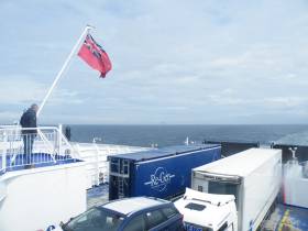
Arran offers a wondrous mix of mountains, forests, lochs, sandy beaches and a whisky distillery. All of this can be reached by taking the Ardrossan-Brodick ferry of only 55 minutes duration. The year-round route’s mainstay, Caledonian Isles (1993/5,221grt) in the high-season is supported by additional capacity from Isle of Arran (1984/3,296grt). In addition the first drive through roll-on roll-off ferry built for CalMac, sails the seasonal Mull of Kintyre route that runs up to late September.

Alternatively, the short cut from Arran back to the mainland, albeit missing out on the Kintyre Peninsula, is by taking from the north of the island the short-hop on board Loch Tarbert (1992/211gt).This smaller ferry plies between Lochranza and Claonaig, that lies south of Tarbert. This option, also requires a drive northwards before heading south to Glasgow and returning to ferryports on Loch Ryan.

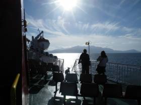
Facilities on board the Ardrossan serving ferries include a ‘Mariners’ restaurant with an emphasis on locally produced food, a giftshop, bar and lounges with forward facing views. On that note, the open deck spaces to soak up these views, unlike the cross-channel ferries, was a most welcomed feature.

The short passage from Ardrossan to Brodick, Arran across the Forth of Clyde presents views of both mainland and that of the looming dominance of the island’s mountain, Goat Fell. The peak of 874m / 2,866ft towers above Brodick Bay.

The Fair Trade island's main town Brodick, has hotels, cafe and gift shops lining the waterfront and nearby sandy beach. On a recent visit, offshore, day-tripper yachts were moored and were joined by an evening arrival of an impressive private three-masted schooner. The yacht took advantage of the sheltered anchorage to overnight in the bay. In the distance thick forests surround Brodick Castle & Gardens, an 800 year-old highland estate, the UK’s only island country park which is open to the public.

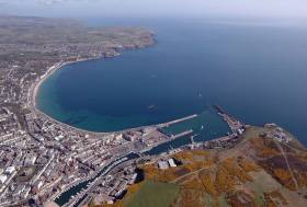
The Mull of Kintyre route, Ardrossan-Campbetown, takes only 2 hours and 30 minutes and on this connection (saving on distance, time and fuel) affords further views off the south coast of Arran. Noting on Saturdays only and in the reverse direction, the ferry departs from Campbeltown to firstly make an en route call to Brodick, Arran before continuing the crossing to Ardrossan.

The approaches to Campbeltown begins with another imposing feature, the steep sided Davaar Island at the entrance to an inlet leading to the port. The harbour is home to a mix of fishing fleet and leisure boats at the marina located conveniently in the centre of the town.

Berthed at the marina, was a ‘passenger-only’ RIB ferry of operator Kintyre Express, which offers an alternative direct service to and from Northern Ireland, on the route out of Ballycastle, Co. Antrim.

It was from the Kintyre coastline could be seen south the ‘North’. In the other direction while taking the Glasgow bound bus were more isles: Gigha, Islay and Jura. An en route stop was made at the stunningly spectacular inland coastal location of Inveraray, on Lough Fyne in which Afloat.ie will have a further report.

Published in Ferry

#UNESCOban? - According to ManxRadio, a ban may be placed on the development of the new Isle of Man Steam Packet site? in Liverpool.

The Manx Government’s proposed ferry terminal in Liverpool could be under threat after a heritage body proposed a ban on development there.

UNESCO awarded the city World Heritage status in 2004, and has now said it wants a moratorium on work near the historic waterfront.

It said failing to comply could mean losing the status – although mayor of Liverpool Joe Anderson has rejected the call.

For more on this story, click here

Published in Ferry

#NorthernLoughs – Inishowen Peninsula, Co. Donegal is unique on the island of Ireland given that two coastal 'car' ferry routes run from both sides of the peninsula, one of which is also a cross-border link, writes Jehan Ashmore.

On the eastern side of the peninsula is where the Lough Foyle Ferry Company operate a 15 minute route between Greencastle, Co. Donegal to Magilligan, Co. Derry-Londonderry. At Greencastle, tomorrow (Sunday 17th July) is to be held the Clipper Family Funday (3-5pm) before the race begins at 6pm.

The year-round Lough Foyle operated route is up and running since Fraser Ferries acquired the cross-border ferry link (see also Passage East Ferry) that was closed last year by a previous management as reported on Afloat.ie. 

It transpires that since that report, the original ferry, Foyle Venture (300 passenger / 44 cars plus lorries) has been retained operating on the Foyle and under Fraser Ferries. The double-ended loading ferry operates 7 days per week and takes 15 minutes crossings. Fares are 20% cheaper, claims the new operator than those of the predecessor in 2015.

Frazer Ferries are also planning to develop another cross border link (Co. Louth/Down)  on Carlingford Lough between Greenore and Greencastle, not to be confused with its Donegal counterpart. Another similarity, it that the crossing times would be the same, 15 minutes.

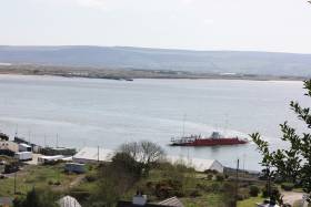
Returning to the Inishowen Peninsula and that of the other side, is where motorists can also benefit travelling onwards in either west or east directions on the seasonal-only Lough Swilly Ferry service. This is the longer of the two routes, taking around 25 minutes to complete between Buncrana and Rathmullan also in Co. Donegal.

A daily service is provided until September, then the only option is by road to Letterkenny.

Likewise of the Foyle route, this service had been under different ownership but since last year having begun using the Coll. The name of the bow-only loading ‘Island’ class ferry reveals her Scottish Western Isles namesake origins.

Entering service in 1974, Coll with a 96 passenger/6 car plus lorry capability, originally served Caledonian MacBrayne/CalMac. The Scottish government owned ferry operator in the Outer Hebrides also known as the Western Isles has an extensive network. Afloat.ie will be reporting on routes among those on the Forth of Clyde. 

Elder sister, Rhum, by only a year, also retains her Scottish isles naming theme albeit now serving in Irish waters and on a mainland-island link. This is between Burtonport and Aranmore Island in northwest Co. Donegal and operated by Aranmore Ferry, a sister company of the operator on Lough Swilly.

Published in Ferry

#DutyFreeReturns? - The UK's decision to leave the EU may see a return of tax-free shopping on Irish Sea crossings between Holyhead, Wales and Ireland reports Daily Post.

Irish day-trippers were a regular sight on the streets of Holyhead during the 1980s and 90s, with the town’s shops and pubs benefiting while visitors took advantage of duty-free sales onboard while sailing.

The practice came to an end in 1999 when the EU scrapped the sale of tax-free alcohol, tobacco and perfume while travelling between member states.

But British voters’ decision to exit the union could pave the way for a return of duty-free shopping according to experts.

For more on the return of duty free? click here

Published in Ferry

#NiceNewService - Former Fastnet Line’s Cork-Swansea ferry which was due to enter Mediterranean service later this month, has since our previous report begun sailings on a new France-Corsica service, writes Jehan Ashmore.

The 1,850 passenger/325 car/30 truck Julia which had served two seasons on the Ireland-Wales route closed following insufficient funds to resume sailings in 2012 and after a failed examinership. A previous operator on the Celtic Sea link was Swansea-Cork Ferries which closed after failing to find suitable replacement tonnage for Superferry that was required back by Greek charterers. 

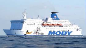
Moby Zazà, the renamed ferry for her new French role between Nice and Bastia, Corsica, had in recent years served as a Dutch owned floating accommodation vessel. As the Wind Perfection she was stationed at anchor during a wind-farm installation project in the Irish Sea.

She was then re-sold to Moby Lines the Italian operator that has deployed the 153m long ferry on the new service. Moby also operate an extensive network to and from the Italian mainland to Sardinia, Elba and Sicily. Consequently, the new service is the operators only service connecting just French ports.

The high-season debut of Moby Zazà (1982/22,161gt) sees her operate sailings in tandem with Moby Corse (1978/14,399gt). The former North Sea veteran last month launched the new service for Moby Lines. 

Overnight sailings are 9.5 hours while daytime passages are 7.5 hours. The service links the resorts of the French Riviera on the Cote d’Azur with those located on one of the largest islands in the western Mediterranean. 

Moby Lines entry on the Nice route marketplace following the collapse of French operator, SNCM which went bankrupt, however after rebranding exercise emerged Corsica Linea this year. SNCM used to serve out of Nice and the successor leaves only existing established operator, Corsica-Sardinia Ferries to compete with Moby Lines. 

Among their Corsica-Italy-Elba routes are more veterans from the Irish Sea, Moby Vincent, the one-time St. Brendan which in 1987 operated in a joint operation between B+I Line and Sealink on the Rosslare-Fishguard route.The 1974 built Scandinavian ferry having made her Irish debut as the chartered Stena Normandica.

The Moby Love in its last career served the Isle of Man Steam Packet to the UK mainland as King Orry but not routes to Ireland. As the St. Eloi she served a stint while on relief duties for Sealink British Ferries on the Dun Laoghaire-Holyhead route. 


Published in Ferry

#Cruise&FerryCode - It was at the European Sea Ports Organisation (ESPO) recently held in Dublin, that the Code of Good Practices for Cruise and Ferry Ports was launched.

The code which is available (here to download) has been developed by ESPO together with Cruise Europe (see conference report) Cruise Baltic, Cruise Norway, MedCruise and Cruise Britain. The organisations have since September 2014 been part of the Cruise and Ferry Port Network.

The aim of the code is to formulate a series of good practices (also as a download) to face the challenges that European cruise and ferry ports are dealing with nowadays.

The five main challenges identified are the port-city relationship, infrastructure, cooperation, relation with the cruise and ferry lines and security. Besides sharing these practices among port authorities, the code can also be seen as an instrument to enhance the dialogue with all stakeholders involved in the cruise and ferry sector. Moreover, this code must inform policy makers and the wider public about the characteristics, challenges and bottom-up initiatives taken by European port authorities.

The code comes with a dynamic online inventory of concrete examples of the good practices outlined in the code. This inventory will be updated continuously and will turn the code into a living document.

Stavros Hatzakos, Chairman of the Cruise and Ferry Network said.“It is an honour to present this first outcome of the Cruise and Ferry Port Network. The cruise and ferry business is an important activity in European ports. Next to the 3.8 billion tonnes of goods that are passing through European ports each year, there are more than 400 million people passing through these same ports. The making of this code has shown the network to be a unique node of knowledge and of exchange of good practices at the service of every port in Europe that wants to improve its performance in the cruise and ferry business and for every port, who is a newcomer in the business.”

Isabelle Ryckbost, ESPO Secretary General added “Even if many ports in Europe are handling both freight and passengers, we see that passenger handling ports demand a specific approach in many areas: be it in infrastructure, where it is important to develop the right “look and feel” for your port; or in the relations with the city where the seasonality of passenger traffic obliges the port to work closely with the city to reduce externalities; or as regards security, where the port wants to ensure a high level of security while being customer friendly. The code also shows how a continuous dialogue with the lines and with the wide range of stakeholders involved in the business can enhance performance and improve the image of the sector”.

Published in Cruise Liners

#BrexitImpact - Ferry operator, Stena Line has said it will have to assess how Brexit could impact the UK. The Swedish company, which sails between Holyhead and Dublin, employs hundreds of workers in North Wales.

A Stena Line spokesman said: "As Brexit is a completely new situation Stena Line will have to evaluate its potential impacts from a number of different perspectives.

"Stena Line is currently working with the UK Chamber of Shipping to consider the implications for all of Stena’s UK interests.

"The UK Chamber of Shipping is an important neutral platform for us to work with the wider shipping community, including its social partners and stakeholders, to better understand the practical implications of a UK exit from the EU.

To read more click WalesOnline here.

Published in Ferry

#FerrytoMed – Former Cork-Swansea ferry Julia of the Fastnet Line that closed in 2011, is to enter service in July on a Mediterranean service between France and Corsica, writes Jehan Ashmore.

As previously reported on Afloat.ie, the Julia (1982/22,161gt) which operated the Ireland-Wales link for only two seasons was re-sold to Italian operator Moby Lines, and is to enter a new Nice-Bastia (Corsica) service. This follows an interim career for Dutch owners as the Wind Perfection that provided floating accommodation in the Irish Sea for workers during construction of a wind-farm.

Under her new owners as Moby Zazà, the 1,850 passenger/325 car/30 truck ferry underwent a drydocking in Liverno to include the company’s customary ‘cartoon’ livery depicting Warner Bros. Looney Tunes characters. She will enter the Nice-Bastia service next month, though the new route was only launched at the beginning of this month.

Commenting to Afloat, a spokesperson for Moby Lines said that in the meantime the route is currently served by Moby Corse (1978/14,399gt). In recent days due to the football matches of Euro 2016 held at the Allianz Arena Nice, Moby Lines have informed customers to expect increased traffic and congestion in the city.

The launch of the Nice-Bastia service which is to be operated year round is in direct competition with established operator, Corsica-Sardinia Ferries. Likewise of the new entrant they have a ferry network that includes routes to and from the France and also the Italian mainland.  

Sailings times connecting the Cote D’Azur and the north-eastern Corsican port are scheduled for 7 hours 30 minutes during the day while overnight crossings will take 9 hours. Moby Zasa was launched as Olau Britannia to serve a first career sailing between Sheerness, UK and Vlissengen, Netherlands along with Olau Hollandia. 

In regards to Moby Corse (as alluded above) this ferry also originally began a career sailing in the North Sea as the Dana Anglia. She served DFDS Seaways service linking England and Denmark and notably the ferry was used as the setting for a 1980’s soap opera TV series ‘Triangle’.

In much more recent times she sailed for Brittany Ferries as Pont-l'Abbé on the Plymouth-Roscoff run. Like numerous northern based European ferries, the final years of these veteran ships are mostly to be seen plying the Mediterranean.

Published in Ferry

#TrailBerthing - The Isle of Man Steam Packet Company has announced its fast craft Manannan will conduct a berthing trial at Holyhead in north Wales.

The trial according to BBC News, will not affect passenger services and is to be carried out overnight on Wednesday.

Its aim is to assess Holyhead's suitability as a back-up to the ferry firm's ports in Liverpool and Heysham.

The company's other vessel, Ben-my-Chree last month had a successful trial at the Anglesey port.

Steam Packet Company Chief Executive Mark Woodward said it was necessary to test other options for Isle of Man sea services.

He added: "This assessment will ensure that we have a full range of contingencies in place to maintain the vital sea links for our passengers and freight customers."

The journey between the Isle of Man and Holyhead would take the Manannan around two hours and the port also has a train station.

Published in Ferry

#UserAgreement - Manx infrastructure minister says the Isle of Man Steam Packet's user agreement is no longer fit for purpose - and will not be extended without major change.

Manx Radio reports that Phil Gawne faced a three-part question in the House of Keys (island's lower parliament) yesterday (14 June) about the company's recent offer to the Manx government, to extend the agreement beyond 2026.

Onchan MHK Peter Karran wanted details on the packet's proposal to invest £170 million in new vessels - if it continues running ferry services to and from the Island.

He also asked what effect that sum would have on the Packet's debt, and on charges for freight and passengers.

Mr Gawne denied a new user agreement had been struck - saying the Packet's finances would need to be 'more transparent' in any new deal.

But he insisted the current system, despite its faults, had been of benefit.

For more about the user agreement listen to Manx Radio by clicking here to link on the webpage

Published in Ferry
Page 8 of 69

General Information on using Waterways Ireland inland navigations

Safety on the Water

All users of the navigations are strongly recommended to make themselves aware of safety on the water for whatever activity they are involved in and to read the advice offered by the various governing bodies and by:

The Dept. of Transport, Ireland: www.gov.ie/transport and The Maritime and Coastguard Agency, UK, The RNLI – Water Safety Ireland for information in terms of drowning prevention and water safety.

Registration of Vessels

All vessels using the Shannon Navigation, which includes the Shannon-Erne Waterways and the Erne System must be registered with Waterways Ireland. Only open undecked boats with an engine of 15 horsepower or less on the Shannon Navigation, and vessels of 10 horsepower or less on the Erne System, are exempt. Registration is free of charge.

Craft registration should be completed online at: https://www.waterwaysireland.org/online-services/craft-registration

Permits for use of the Grand and Royal Canals and the Barrow Navigation

All vessels using the Grand and Royal Canals and the Barrow Navigation must display appropriate valid Permit(s) i.e A Combined Mooring and Passage Permit (€126) and if not intending to move every five days, an Extended Mooring Permit (€152).

Permit applications should be completed online at: https://www.waterwaysireland.org/online-services/canal-permits

Passage on the Royal and Grand Canals – Dublin Area

For boat passage through the locks east of Lock 12 into / out of Dublin on either the Royal or Grand Canals, Masters are requested to contact the Waterways Ireland Eastern Regional Office (M-F 9.30am-4.30pm) on tel: +353(0)1 868 0148 or email [email protected] prior to making passage in order to plan the necessary lock-keeping assistance arrangements.

On the Grand Canal a minimum of two days notice prior to the planned passage should be given, masters should note that with the exception of pre-arranged events, a maximum of 2 boats per day will be taken through the locks, travelling either east or west.

Movements in or out of the city will be organised by prior arrangement to take place as a single movement in one day. Boaters will be facilitated to travel the system if their passage is considered to be safe by Waterways Ireland and they have the valid permit(s) for mooring and passage.

Newcomen Lifting Bridge

On the Royal Canal two weeks’ notice of bridge passage (Newcomen Lifting Bridge) is required for the pre-set lift date, and lock assistance will then also be arranged. A minimum of 2 boats is required for a bridge lift to go ahead.

Waterways Ireland Eastern Regional Office (Tel: +353(0)1 868 0148 or [email protected] ) is the point of contact for the bridge lift.

A maximum number of boats passing will be implemented to keep to the times given above for the planned lifts (16 for the Sat / Sun lifts & 8 for the weekday lifts). Priority will be given on a first come first served basis.

On day of lift, boaters and passengers must follow guidance from Waterways Ireland staff about sequence of passage under bridge & through Lock 1, and must remain within signed and designated areas.

Events Held on the Waterways

All organised events taking place on the waterways must have the prior approval of Waterways Ireland. This is a twelve week process and application forms must be accompanied with the appropriate insurance, signed indemnity and risk assessment. The application should be completed on the Waterways Ireland events page at :

https://www.waterwaysireland.org/online-services/event-approval

Time Limits on Mooring in Public Harbours

On the Shannon Navigation and the Shannon-Erne Waterway craft may berth in public harbours for five consecutive days or a total of seven days in any one month.

On the Erne System, revised Bye Laws state that: No master or owner shall permit a vessel, boat or any floating or sunken object to remain moored at or in the vicinity of any public mooring, including mooring at any other public mooring within 3 kilometres of that location, for more than 3 consecutive days and shall not moor at that same mooring or any other public mooring within 3 kilometres of that location within the following 3 consecutive days without prior permission by an authorised official.

Winter Mooring on the Shannon Navigation and Shannon Erne Waterway

Winter mooring may be availed of by owners during the period 1 Nov to 31 Mar by prior arrangement and payment of a charge of €63.50 per craft. Craft not availing of Winter Mooring must continue to comply with the “5 Day Rule”. Winter Mooring applications should be completed online at : https://www.waterwaysireland.org/online-services/winter-moorings-booking

Owners should be aware that electricity supply and water supply to public moorings is disconnected for the winter months. This is to protect against frost damage, to reduce running costs and to minimise maintenance requirements during the winter months.

Vessel owners are advised that advance purchasing of electricity on the power bollards leading up to the disconnection date should be minimal. Electricity credit existing on the bollards will not be recoverable after the winter decommissioning date. Both services will be reinstated prior to the commencement of the next boating season.

Smart Cards

Waterways Ireland smart cards are used to operate locks on the Shannon Erne Waterway, to access the service blocks, to use the pump-outs along the navigations, to avail of electrical power at Waterways Ireland jetties.

Berthing in Public Harbours

Masters are reminded of the following:

  • Equip their vessel with mooring lines of appropriate length and strength and only secure their craft to mooring bollards and cleats provided for this purpose.
  • Ensure the available berth is suitable to the length of your vessel, do not overhang the mooring especially on finger moorings on floating pontoon moorings.
  • Ensure mooring lines, electric cables and fresh water hoses do not create a trip hazard on public jetties for others users.
  • Carry sufficient fenders to prevent damage to your own vessel, other vessels and WI property.
  • Allow sufficient space between your vessel and the vessel ahead /astern (c.1m) for fire safety purposes and /or to recover somebody from the water.
  • Do not berth more than two vessels side by side and ensure there is safe access/egress at all times between vessels and onto the harbour itself.
  • Do not berth in such a way to prevent use of harbour safety ladders, slipways or pump-outs.
  • Do not allow the bow of your vessel to overhang the walkway of a floating mooring thus creating a hazard for others with an overhanging anchor or bow fendering.
  • Animals are not allowed to be loose or stray at any time.
  • Harbour and jetty infrastructure such as railings, power pedestals, fresh water taps, electric light poles, safety bollards, ladders etc are not designed for the purpose of mooring craft , they will not bear the strain of a vessel and will be damaged.
  • At Carrybridge on the Erne System, Masters of vessels are not permitted to use stern on mooring. Masters of vessels must use the mooring fingers for mooring of vessels and for embarkation / disembarkation from vessels.

Passenger Vessel Berths

Masters of vessels should not berth on passenger vessel berths where it is indicated that an arrival is imminent. Passenger vessels plying the navigations generally only occupy the berths to embark and disembark passengers and rarely remain on the berths for extended periods or overnight.

Lock Lead-in Jetties

Lead-in jetties adjacent to the upstream and downstream gates at lock chambers are solely for the purpose of craft waiting to use the lock and should not be used for long term berthing.

Vessel Wake

Vessel wake, that is, the wave generated by the passage of the boat through the water, can sometimes be large, powerful and destructive depending on the hull shape and engine power of the vessel. This wake can be detrimental to other users of the navigation when it strikes their craft or inundates the shoreline or riverbank. Masters are requested to frequently look behind and check the effect of their wake / wash particularly when passing moored vessels, on entering harbours and approaching jetties and to be aware of people pursuing other activities such as fishing on the riverbank.

Speed Restriction

A vessel or boat shall not be navigated on the Shannon Navigation at a speed in excess of 5 kph when within 200 metres of a bridge, quay, jetty or wharf, when in a harbour or canal or when passing within 100 metres of a moored vessel or boat.

Vessels navigating the Shannon-Erne Waterway should observe the general 5 kph speed limit which applies along the waterway. This is necessary in order to prevent damage to the banks caused by excessive wash from vessels.

Vessels navigating the Erne System should observe the statutory 5kt / 6mph / 10kph speed limit areas.

A craft on the Royal and Grand canals shall not be navigated at a speed in excess of 6km per hour.

A craft on the Barrow Navigation shall not be navigated at a speed in excess of 11km per hour except as necessary for safe navigation in conditions of fast flow.

Bank Erosion

Narrow sections of all the navigations are particularly prone to bank erosion due to the large wash generated by some craft. Masters are requested to be vigilant and to slow down to a speed sufficient to maintain steerage when they observe the wash of their craft inundating the river banks.

Unusual Waterborne Activity

Unusual waterborne vessels may be encountered from time to time, such as, hovercraft or amphibious aircraft / seaplanes. Masters of such craft are reminded to apply the normal “Rule of the Road” when they meet conventional craft on the water and to allow extra room to manoeuvre in the interest of safety.

Sailing Activity

Mariners will encounter large numbers of sailing dinghies from late June to August in the vicinity of Lough Derg, Lough Ree and Lower Lough Erne. Sailing courses are marked by yellow buoys to suit weather conditions on the day. Vessels should proceed at slow speed and with due caution and observe the rules of navigation when passing these fleets, as many of the participants are junior sailors under training.

Rowing

Mariners should expect to meet canoes and vessels under oars on any part of the navigations, but more so in the vicinity of Athlone, Carrick-on-Shannon, Coleraine, Enniskillen and Limerick. Masters are reminded to proceed at slow speed and especially to reduce their wash to a minimum when passing these craft as they can be easily upset and swamped due to their very low freeboard and always be prepared to give way in any given traffic situation.

Canoeing

Canoeing is an adventure sport and participants are strongly recommended to seek the advice of the sport’s governing bodies i.e Canoeing Ireland and the Canoe Association of Northern Ireland, before venturing onto the navigations.

Persons in charge of canoes are reminded of the inherent danger to these craft associated with operating close to weirs, sluice gates, locks and other infrastructure particularly when rivers are in flood and large volumes of water are moving through the navigations due to general flood conditions or very heavy localised precipitation e.g. turbulent and broken water, stopper waves. Shooting weirs is prohibited without prior permission of Waterways Ireland.

Canoeists should check with lockkeepers prior entering a lock to ensure passage is done in a safe manner. Portage is required at all unmanned locks.

Canoe Trail Network – "Blueways"

Masters of powered craft are reminded that a canoe trail network is being developed across all navigations and to expect more organised canoeing along these trails necessitating slow speed and minimum wash when encountering canoeists, rowing boats etc

Rockingham and Drummans Island Canals – Lough Key

It is expected that work on Rockingham and Drummans Island Canals on Lough Key will be completed in 2021. Access to these canals will be for non-powered craft only, eg canoes, kayaks, rowing boats.

Fast Powerboats and Personal Watercraft (Jet Skis)

Masters of Fast Powerboats (speed greater than 17kts) and Personal Watercraft (i.e.Jet Skis) are reminded of the inherent dangers associated with high speed on the water and especially in the confines of small bays and narrow sections of the navigations. Keeping a proper look-out, making early alterations to course and /or reducing speed will avoid conflict with slower vessels using the navigation. Personal Watercraft are not permitted to be used on the canals.

Towing Waterskiers, Wakeboarders, Doughnuts etc

Masters of vessels engaged in any of these activities are reminded of the manoeuvring constraints imposed upon their vessel by the tow and of the added responsibilities that they have to the person(s) being towed. These activities should be conducted in areas which are clear of conflicting traffic. It is highly recommended that a person additional to the master be carried to act as a “look-out” to keep the tow under observation at all times.

Prohibition on Swimming

Swimming in the navigable channel, particularly at bridges, is dangerous and is prohibited due to the risk of being run over by a vessel underway in the navigation.

Age Restrictions on operating of powered craft

In the Republic of Ireland, Statutory Instrument 921 of 2005 provides the legal requirements regarding the minimum age for operating of powered craft. The Statutory Instrument contains the following requirements:

- The master or owner of a personal watercraft or a fast power craft shall take all reasonable steps to ensure that a person who has not attained the age of 16 years does not operate or control the craft

- The master or owner of a pleasure craft powered by an engine with a rating of more than 5 horse power or 3.7 kilowatts shall take all reasonable steps to ensure that a person who has not attained the age of 12 years does not operate or control the craft.

Lifejackets and Personal Flotation Devices (PFDs)

Lifejackets and PFD’s are the single most important items of personal protective equipment to be used on a vessel and should be worn especially when the vessel is being manoeuvred such as entering / departing a lock, anchoring, coming alongside or departing a jetty or quayside.

In the Republic of Ireland, Statutory Instrument 921 of 2005 provides the legal requirements regarding the wearing of Personal Flotation Devices. The Statutory Instrument contains the following requirements:

- The master or owner of a pleasure craft (other than a personal watercraft) shall ensure, that there are, at all times on board the craft, sufficient suitable personal flotation devices for each person on board.

- A person on a pleasure craft (other than a personal watercraft) of less than 7 metres length overall shall wear a suitable personal flotation device while on board an open craft or while on the deck of decked craft, other than when the craft is made fast to the shore or at anchor.

- The master or owner of a pleasure craft (other than a personal watercraft) shall take all reasonable steps to ensure that a person who has not attained the age of 16 years complies with paragraph above.

- The master or owner of a pleasure craft (other than a personal watercraft), shall take all reasonable steps to ensure that a person who has not attained the age of 16 years wears a suitable personal flotation device while on board an open craft or while on the deck of a decked craft other than when it is made fast to the shore or at anchor.

- The master or owner of a pleasure craft (other than a personal watercraft) shall take all reasonable steps to ensure that a person wears a suitable personal flotation device, at all times while – (a) being towed by the craft, (b) on board a vessel or object of any kind which is being towed by the craft.

Further information is available at: http://www.irishstatutebook.ie/eli/2005/si/921/made/en/print

Firing Range Danger Area – Lough Ree

The attention of mariners is drawn to the Irish Defence Forces Firing Range situated in the vicinity of buoys No’s 2 and 3, on Lough Ree on the Shannon Navigation. This range is used regularly for live firing exercises, throughout the year, all boats and vessels should stay clear of the area marked with yellow buoys showing a yellow "X" topmark and displaying the word "Danger".

Shannon Navigation, Portumna Swing Bridge Tolls

No attempt should be made by Masters’ of vessels to pay the bridge toll while making way through the bridge opening. Payment will only be taken by the Collector from Masters when they are secured alongside the jetties north and south of the bridge.

Navigating from Killaloe to Limerick on the Shannon Navigation

The navigation from Killaloe to Limerick involves passage through Ardnacrusha locks, the associated headrace and tailrace and the Abbey River into Limerick City. Careful passage planning is required to undertake this voyage. Considerations include: lock passage at Ardnacrusha, water flow in the navigation, airdraft under bridges on Abbey River in Limerick, state of tide in Limerick

Users are advised to contact the ESB Ardnacrusha hydroelectric power station (00353 (0)87 9970131) 48 hours in advance of commencing their journey to book passage through the locks at Ardnacrusha. It is NOT advised to undertake a voyage if more than one turbine is operating (20MW), due to the increased velocity of flow in the navigation channel, which can be dangerous. To ascertain automatically in real time how many turbines are running, users can phone +353 (0)87 6477229.

For safety reasons the ESB has advised that only powered craft with a capacity in excess of 5 knots are allowed to enter Ardnacrusha Headrace and Tailrace Canals.

Passage through Sarsfield Lock should be booked on +353-87-7972998, on the day prior to travel and it should be noted also that transit is not possible two hours either side of low water.

A Hydrographic survey in 2020 of the navigation channel revealed that the approach from Shannon Bridge to Sarsfield Lock and the Dock area has silted up. Masters of vessels and water users are advised to navigate to the Lock from Shannon bridge on a rising tide one or two hours before High Tide.

Lower Bann Navigation

The attention of all users is drawn to the “Users Code for the Lower Bann”, in particular to that section covering “Flow in the River” outlining the dangers for users both on the banks and in the navigation, associated with high flow rates when the river is in spate. Canoeists should consult and carry a copy of the “Lower Bann Canoe Trail” guide issued by the Canoe Association of Northern Ireland. Users should also contact the DfI Rivers Coleraine, who is responsible for regulating the flow rates on the river, for advisory information on the flow rates to be expected on any given day.

DfI Rivers Coleraine. Tel: 0044 28 7034 2357 Email: [email protected]

Lower Bann Navigation – Newferry – No wake zone

A No Wake Zone exists on the Lower Bann Navigation at Newferry. Masters of vessels are requested to proceed at a slow speed and create no wake while passing the jetties and slipways at Newferry.

Overhead Power Lines (OHPL) and Air draft

All Masters must be aware of the dangers associated with overhead power lines, in particular sailing vessels and workboats with cranes or large air drafts. Voyage planning is a necessity in order to identify the location of overhead lines crossing the navigation.

Overhead power line heights on the River Shannon are maintained at 12.6metres (40 feet) from Normal Summer level for that section of navigation, masters of vessels with a large air draft should proceed with caution and make additional allowances when water levels are high.

If a vessel or its equipment comes into contact with an OHPL the operator should NOT attempt to move the vessel or equipment. The conductor may still be alive or re-energise automatically. Maintain a safe distance and prevent third parties from approaching due to risk of arcing. Contact the emergency services for assistance.

Anglers are also reminded that a minimum ground distance of 30 metres should be maintained from overhead power lines when using a rod and line.

Submarine Cables and Pipes

Masters of vessels are reminded not to anchor their vessels in the vicinity of submarine cables or pipes in case they foul their anchor or damage the cables or pipes. Look to the river banks for signage indicating their presence.

Water Levels - Precautions

Low Water Levels:

When water levels fall below normal summer levels masters should be aware of:

Navigation

To reduce the risk of grounding masters should navigate on or near the centreline of the channel, avoid short cutting in dog-legged channels and navigating too close to navigation markers.

Proceeding at a slow speed will also reduce “squat” effect i.e. where the vessel tends to sit lower in the water as a consequence of higher speed.

Slipways

Reduced slipway length available under the water surface and the possibility of launching trailers dropping off the end of the concrete apron.

More slipway surface susceptible to weed growth requiring care while engaged in launching boats, from slipping and sliding on the slope. Note also that launching vehicles may not be able to get sufficient traction on the slipway once the craft is launched to get up the incline.

Bank Erosion

Very dry riverbanks are more susceptible to erosion from vessel wash.

Lock Share

Maximising on the number of vessels in a lock will ensure that the total volume of water moving downstream is decreased. Lock cycles should be used for vessels travelling each way.

High Water Levels:

When water levels rise above normal summer level masters should be aware of:

Navigation

Navigation marks will have reduced height above the water level or may disappear underwater altogether making the navigable channel difficult to discern.

In narrow sections of the navigations water levels will tend to rise more quickly than in main streams and air draft at bridges will likewise be reduced.

There will also be increased flow rates particularly in the vicinity of navigation infrastructure such as bridges, weirs, locks etc where extra care in manoeuvring vessels will be required.

Harbours and Jetties

Due care is required in harbours and at slipways when levels are at or near the same level as the harbour walkways' as the edge will be difficult to discern especially in reduced light conditions. It is advised that Personal Flotation Devices be worn if tending to craft in a harbour in these conditions.

Slipways

Slipways should only be used for the purpose of launching and recovering of water craft or other objects from the water. Before using a slipway it should be examined to ensure that the surface has sufficient traction/grip for the intended purpose such as launching a craft from a trailer using a vehicle, that there is sufficient depth of water on the slipway to float the craft off the trailer before the concrete apron ends and that the wheels of the trailer do not drop off the edge of the slipway. That life-saving appliances are available in the vicinity, that the vehicle is roadworthy and capable of coping with the weight of the trailer and boat on the incline. It is recommended that slipway operations are conducted by two persons.

Caution to be Used in Reliance upon Aids to Navigation

The aids to navigation depicted on the navigation guides comprise a system of fixed and floating aids to navigation. Prudent mariners will not rely solely on any single aid to navigation, particularly a floating aid to navigation. With respect to buoys, the buoy symbol is used to indicate the approximate position of the buoy body and the ground tackle which secures it to the lake or river bed. The approximate position is used because of the practical limitations in positioning and maintaining buoys in precise geographical locations. These limitations include, but are not limited to, prevailing atmospheric and lake/river conditions, the slope of and the material making up the lake/river bed, the fact that the buoys are moored to varying lengths of chain, and the fact that the buoy body and/or ground tackle positions are not under continuous surveillance. Due to the forces of nature, the position of the buoy body can be expected to shift inside and outside the charted symbol.

Buoys and perches are also moved out of position or pulled over by those mariners who use them to moor up to instead of anchoring. To this end, mariners should always monitor their passage by relating buoy/perch positions with the published navigation guide. Furthermore, a vessel attempting to pass close by always risks collision with a yawing buoy or with the obstruction that the buoy or beacon/perch marks.

Masters of Vessels are requested to use the most up to date Navigation guides when navigating on the Inland Waterways.

Information taken from Special Marine Notice No 1 of 2023