Menu

Ireland's sailing, boating & maritime magazine

Inland afloat headers


Displaying items by tag: SteamPacket

'Serious concerns' have been raised by the Isle of Man Steam Packet in regards to the effect of growing windfarms in the Irish Sea.

As 3FM reports, the ferry operator has concerns following proposals for the windfarm of 'Morecambe and Morgan' which would be based in the Irish Sea.

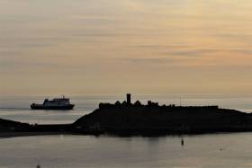
The proposed windfarm would be in an area south-east of the Island along the route taken by the company's fast-ferry operating between Douglas and Liverpool. The 69 nautical mile route links the Manx capital to Merseyside where a new terminal is currently under construction.

Across the Island, leaflets have been posted asking for views expressed from the public. In addition a consultation process has been launched online which gives details of consultation venues and dates aswell as for pop-events noting an online event is scheduled for 10 November. 

The Steam Packet posted on its website to say that it's 'supportive of sustainability and renewable energy' - and 'broadly speaking' the company supports initiatives to tackle energy challgenges.

More here on this renewable energy project story.
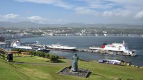
Published in Ferry

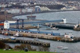
A planning application submitted by the Isle of Man Government's Department of Infrastructure (DoI) to improve Douglas Harbour is an important development according to the Minister.

It's for a marine dolphin and footbridge on King Edward VIII pier, and would include installing a mooring platform and mooring bollard.

Additional work not included in the plans will also be carried out which doesn't need approval by the planning board.

Chris Thomas says the work will improve the harbour in bad weather especially, and explains what marine dolphins are: (according to Manx Radio's audio clip that includes reference to newbuild ferry Manxman due in 2023).  

The Minister added that the application has been put together in consultation with the Isle of Man Steam Packet, and more details will be given to Tynwald members and the public in September.

The Steam Packet has declined our invitation to comment.

Published in Isle of Man

The Isle of Man Government's Department of Infrastructure wants to build a dolphin and footbridge in Douglas Harbour.

As Manx Radio reports, plans have been published to extend one of the harbour's piers used by ferry operator, the IOM Steam Packet Company.

The DoI has submitted a planning application for a marine dolphin and footbridge on King Edward VIII Pier.

The application says the scheme would include installing a mooring platform and bollard, as well as additional work not included in the plans as it would not need approval by the planning board.

The site is in a high-risk flood zone, but the department says it has not carried out a flood risk assessment as the structure will be founded in the seabed.

Published in Isle of Man

Around 300 passengers enjoyed spectacular views of the Isle of Man’s coastline on this year’s Ben-my-Chree round-the-island cruise which was held last Saturday following Midsummer's day. 

The ropax which the IOM Steam-Packet operates on the route to Heysham, England, departed Douglas at 19:00hrs on the special cruise which first went across the bay towards Onchan Head, swinging back around and continuing south. From there the cruise which included a meal as part of the fare offered further stunning views of Port Erin Bay followed by Peel and its castle. 

The fine evening meant that the crew were able to open up Deck 5 to allow passengers to get a great look at the coastline from the vehicle deck. There was also a refurbished motorised horse tram on the deck which made a great vantage point and photo opportunity.

It was an enjoyable evening for all with stunning coastal views, delicious food and musical entertainment from Douglas Town Band’s oompah act, Baron Otto's Blaskapelle, who performed several sets in the ship’s bar throughout the cruise.

Published in Ferry

#ferries - Manx minister for Enterprise wants to see fewer sailings operating at low capacity.

According to Manx Radio, the 2018 Isle of Man Passenger Survey results show the number of people travelling by sea dropped by 6% last year.

Tynwald (the island's Parliament) recently approved a plan for the future of the Isle of Man Steam Packet Company, after the government purchased the ferry operator last year.

Laurence Skelly is keen to attract more tourists to fill the empty seats.

To listen and watch the Minister speak on the radio station click the link here. 

Published in Ferry

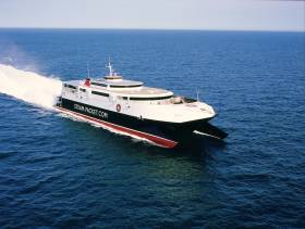
#ferries - The Isle of Man Steam Packet's fastcraft Manannan arrived to Dublin Port yesterday to carry out berthing trials against the backdrop of port capacity restrictions and challenges posed by Brexit, writes Jehan Ashmore.

Prior to entering the port by the 850 passenger/200 vehicle Manannan, a routine yet busy succession of ferry and ro-ro freight ships departed through Dublin Bay. They were all bound for the UK to the ports of Holyhead, Liverpool and Heysham.

The Steam-Packet confirmed to Afloat.ie that the Manannan conducted the berthing trials on two berths to determine if either could be used as a back-up in the event access to the normally used berth (at Terminal No.1, the port's busiest) should it be restricted or out of action.

Acquired by the Manx Government last year, the ferry operator is set to resume seasonal service linking Douglas and Dublin on Thursday, 18 April in advance of the Easter Bank Holiday weekend. The 96m Manannan which has operated on the Irish Sea since 2009 is however first scheduled to resume on another seasonal service this week between Douglas and Belfast when sailings start on Sunday, 7 April.

Afloat monitored Manannan carry out the first berthing trial in Dublin where Stena Line operate out of Terminal 2. The terminal is located adjacent to where rivals Irish Ferries use the port's busiest ferry facility at Terminal 1. Also berthed there was another fastcraft, Dublin Swift which during the St. Patrick's Festival began a second summer season for Irish Ferries on the core Irish Sea route to Holyhead in tandem with Ulysses and the chartered-in ropax Epsilon.

In addition at Terminal 1 last month saw the introduction of Irish Ferries much anticipated new giant cruiseferry W.B. Yeats (onto the Dublin-France service) which has doubled in the number sailings by up to 4 weekly on the continental link to Cherbourg. Up to then Epsilon served this route and Oscar Wilde since September, following the apparent closure of Rosslare based routes to France (see below).

W.B. Yeats which at 51,388grt is the largest ferry ever to operate out of Ireland and also brings a Brexit related boost to capacity on the direct link to mainland Europe though seemingly at the expense of Rosslare Europort and the south-east region. As in December, Irish Ferries announced they would unlikely resume services to France in 2019 but added they would keep this situation under review. In the meantime the 1987 built Oscar Wilde remains in dry-dock at Harland & Wolff, Belfast, so what beckons for the future of this cruiseferry?

As widely reported in the media, Dublin Port has imposed restrictions by placing a limit on the number of cruiseships calling to the capital. This is due to Brexit which will force the port to handle increased amounts of freight and cargo directly from mainland Europe, as distinct to depending on services that make up the UK land-bridge to mainland Europe. This will lead to more considered allocation of berths and in particular at Alexandra Basin where a major redevelopment is ongoing as part of the port's Masterplan. 

The second of Manannan's Dublin berthing trials took place upriver at Ocean Pier (notably not a ferry passenger terminal). Located here at this same berth linkspan in Alexandra Basin (East) is where the latest Brexit-Buster the newbuild ro-ro freight ship Laureline made a maiden call last week. The giant ship is among the operator, CLnD's fleet including Celine but docks at the adjacent Alexandra Basin from also where direct services run to Zeebrugge in Belgium and Europe's largest port, Rotterdam in The Netherlands.

Laureline which is around the same size in gross tonnage terms of W.B. Yeats, is to return for only the second time to Dublin Port today with an arrival around lunch-hour.

Published in Ferry

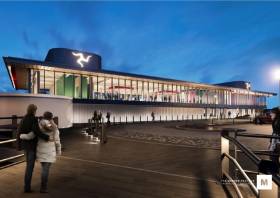
#FerryNews- The new ferry terminal planned for Liverpool the IOMToday reports have included images that have been unveiled.

The pictures have been released ahead of a public display in Liverpool this week. A planning application is due to be submitted next month.

The images show that the new building would be glass fronted with a steel frame, with passengers welcomed in English and Manx above the main door.

Infrastructure Minister Ray Harmer MHK said: ’The proposed terminal has been designed to combine a high standard of civil engineering with a high quality building.’

Car passengers will enter from the road currently under construction as part of Liverpool’s city centre connection project, with bus and taxi spaces provided.

Foot passengers will be able to enter along the access bridge, which is at the rear of the Alexandra Tower.

Freight vehicles will wait to board boats in a designated area next to the river.

For more on the development. click here. 

Published in Ferry

#FerryNews - IOM Today reports of a newly-formed lobby group that says it has ’serious concerns’ about the ’strategic vulnerablility’ of Douglas port.

Isle of Man Maritime Ltd, a not-for-profit company which has replaced the Isle of Man Shipping Association, points out the harbour is too small to handle the larger roll-on, roll-off vessels that are now the norm.

And it says there is no contingency plan should there be a serious incident in the harbour which blocks it to other sea traffic.

It issued the statement after Tynwald last month backed an £80m strategy to redevelop Douglas harbour and attract more cruise liners to the island.

The Shipping Association had proposed a £35m-40m scheme for a fixed deep water landing stage on the seaward-side of the breakwater that protects Douglas harbour.

For further reading of this development, click here. 
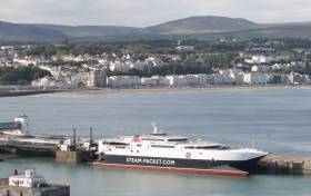
Published in Ferry

#FerryNews-  The Isle of Man Steam Packet Company has reported an upturn in visitor numbers last year.

Booking data reports Manx Radio from the ferry operator shows an increase of 3.4% in ferry passengers compared to 2016.

It comes in spite of Cabinet Office figures indicating a sharp fall in visitors to the Island last year - findings which have come under doubt from parts of the tourism industry.

Passenger departures from Liverpool, Birkenhead, Belfast and Dublin are all up, with only a small decrease in those coming from Heysham.

Steam Packet Chief Executive Mark Woodward says continued investment in promotion of the Island, as well an increased UK marketing budget, are factors in the continued growth in numbers.

Published in Ferry

#FerryNews - This morning the first Dublin-Isle of Man sailing for season 2018 began with fastferry Manannan departing on time at 10.45 in advance of the Easter Bank Holiday weekend, writes Jehan Ashmore.

The fast ferry service taking 2hrs 55mins is operated by the Isle of Man Steam Packet Company. Manannan made an arrival to the Irish capital having departed on the outward leg from Douglas at 07.00.

In recent days Manannan also resumed daily operated Isle of Man sailings to Liverpool and yesterday began serving through Belfast. These sailings compared to the Dublin route are marginally shorter taking 2hrs 45mins on the Ulster link.

On occasions when conventional ropax Ben-My-Chree provides these services, the sailing times are longer on both the Irish routes. 

The Steam-Packet has more than 900,000 offer seats available during the season. Company Chief Executive Mark Woodward said: ‘The return of our fast craft Manannan is always an exciting and busy time for us, and we are looking forward to welcoming our passengers on board. It is always great to see a combination of Island residents heading off on their travels, along with curious visitors on their way to discover our special island!’

Manannan can take 200 vehicles and 850 passenger and crew. There are a variety of seating areas, including two cinema lounges, a large bar area at the stern and the Coast-to-Coast cafe that offers a wide selection of food options.

On the upper deck is the enlarged skylounge providing accommodation for the Niarbyl Reserved Lounge, the Manannan Premium Lounge and the Manannan Executive Club. 

Published in Ferry
Page 1 of 2

General Information on using Waterways Ireland inland navigations

Safety on the Water

All users of the navigations are strongly recommended to make themselves aware of safety on the water for whatever activity they are involved in and to read the advice offered by the various governing bodies and by:

The Dept. of Transport, Ireland: www.gov.ie/transport and The Maritime and Coastguard Agency, UK, The RNLI – Water Safety Ireland for information in terms of drowning prevention and water safety.

Registration of Vessels

All vessels using the Shannon Navigation, which includes the Shannon-Erne Waterways and the Erne System must be registered with Waterways Ireland. Only open undecked boats with an engine of 15 horsepower or less on the Shannon Navigation, and vessels of 10 horsepower or less on the Erne System, are exempt. Registration is free of charge.

Craft registration should be completed online at: https://www.waterwaysireland.org/online-services/craft-registration

Permits for use of the Grand and Royal Canals and the Barrow Navigation

All vessels using the Grand and Royal Canals and the Barrow Navigation must display appropriate valid Permit(s) i.e A Combined Mooring and Passage Permit (€126) and if not intending to move every five days, an Extended Mooring Permit (€152).

Permit applications should be completed online at: https://www.waterwaysireland.org/online-services/canal-permits

Passage on the Royal and Grand Canals – Dublin Area

For boat passage through the locks east of Lock 12 into / out of Dublin on either the Royal or Grand Canals, Masters are requested to contact the Waterways Ireland Eastern Regional Office (M-F 9.30am-4.30pm) on tel: +353(0)1 868 0148 or email [email protected] prior to making passage in order to plan the necessary lock-keeping assistance arrangements.

On the Grand Canal a minimum of two days notice prior to the planned passage should be given, masters should note that with the exception of pre-arranged events, a maximum of 2 boats per day will be taken through the locks, travelling either east or west.

Movements in or out of the city will be organised by prior arrangement to take place as a single movement in one day. Boaters will be facilitated to travel the system if their passage is considered to be safe by Waterways Ireland and they have the valid permit(s) for mooring and passage.

Newcomen Lifting Bridge

On the Royal Canal two weeks’ notice of bridge passage (Newcomen Lifting Bridge) is required for the pre-set lift date, and lock assistance will then also be arranged. A minimum of 2 boats is required for a bridge lift to go ahead.

Waterways Ireland Eastern Regional Office (Tel: +353(0)1 868 0148 or [email protected] ) is the point of contact for the bridge lift.

A maximum number of boats passing will be implemented to keep to the times given above for the planned lifts (16 for the Sat / Sun lifts & 8 for the weekday lifts). Priority will be given on a first come first served basis.

On day of lift, boaters and passengers must follow guidance from Waterways Ireland staff about sequence of passage under bridge & through Lock 1, and must remain within signed and designated areas.

Events Held on the Waterways

All organised events taking place on the waterways must have the prior approval of Waterways Ireland. This is a twelve week process and application forms must be accompanied with the appropriate insurance, signed indemnity and risk assessment. The application should be completed on the Waterways Ireland events page at :

https://www.waterwaysireland.org/online-services/event-approval

Time Limits on Mooring in Public Harbours

On the Shannon Navigation and the Shannon-Erne Waterway craft may berth in public harbours for five consecutive days or a total of seven days in any one month.

On the Erne System, revised Bye Laws state that: No master or owner shall permit a vessel, boat or any floating or sunken object to remain moored at or in the vicinity of any public mooring, including mooring at any other public mooring within 3 kilometres of that location, for more than 3 consecutive days and shall not moor at that same mooring or any other public mooring within 3 kilometres of that location within the following 3 consecutive days without prior permission by an authorised official.

Winter Mooring on the Shannon Navigation and Shannon Erne Waterway

Winter mooring may be availed of by owners during the period 1 Nov to 31 Mar by prior arrangement and payment of a charge of €63.50 per craft. Craft not availing of Winter Mooring must continue to comply with the “5 Day Rule”. Winter Mooring applications should be completed online at : https://www.waterwaysireland.org/online-services/winter-moorings-booking

Owners should be aware that electricity supply and water supply to public moorings is disconnected for the winter months. This is to protect against frost damage, to reduce running costs and to minimise maintenance requirements during the winter months.

Vessel owners are advised that advance purchasing of electricity on the power bollards leading up to the disconnection date should be minimal. Electricity credit existing on the bollards will not be recoverable after the winter decommissioning date. Both services will be reinstated prior to the commencement of the next boating season.

Smart Cards

Waterways Ireland smart cards are used to operate locks on the Shannon Erne Waterway, to access the service blocks, to use the pump-outs along the navigations, to avail of electrical power at Waterways Ireland jetties.

Berthing in Public Harbours

Masters are reminded of the following:

  • Equip their vessel with mooring lines of appropriate length and strength and only secure their craft to mooring bollards and cleats provided for this purpose.
  • Ensure the available berth is suitable to the length of your vessel, do not overhang the mooring especially on finger moorings on floating pontoon moorings.
  • Ensure mooring lines, electric cables and fresh water hoses do not create a trip hazard on public jetties for others users.
  • Carry sufficient fenders to prevent damage to your own vessel, other vessels and WI property.
  • Allow sufficient space between your vessel and the vessel ahead /astern (c.1m) for fire safety purposes and /or to recover somebody from the water.
  • Do not berth more than two vessels side by side and ensure there is safe access/egress at all times between vessels and onto the harbour itself.
  • Do not berth in such a way to prevent use of harbour safety ladders, slipways or pump-outs.
  • Do not allow the bow of your vessel to overhang the walkway of a floating mooring thus creating a hazard for others with an overhanging anchor or bow fendering.
  • Animals are not allowed to be loose or stray at any time.
  • Harbour and jetty infrastructure such as railings, power pedestals, fresh water taps, electric light poles, safety bollards, ladders etc are not designed for the purpose of mooring craft , they will not bear the strain of a vessel and will be damaged.
  • At Carrybridge on the Erne System, Masters of vessels are not permitted to use stern on mooring. Masters of vessels must use the mooring fingers for mooring of vessels and for embarkation / disembarkation from vessels.

Passenger Vessel Berths

Masters of vessels should not berth on passenger vessel berths where it is indicated that an arrival is imminent. Passenger vessels plying the navigations generally only occupy the berths to embark and disembark passengers and rarely remain on the berths for extended periods or overnight.

Lock Lead-in Jetties

Lead-in jetties adjacent to the upstream and downstream gates at lock chambers are solely for the purpose of craft waiting to use the lock and should not be used for long term berthing.

Vessel Wake

Vessel wake, that is, the wave generated by the passage of the boat through the water, can sometimes be large, powerful and destructive depending on the hull shape and engine power of the vessel. This wake can be detrimental to other users of the navigation when it strikes their craft or inundates the shoreline or riverbank. Masters are requested to frequently look behind and check the effect of their wake / wash particularly when passing moored vessels, on entering harbours and approaching jetties and to be aware of people pursuing other activities such as fishing on the riverbank.

Speed Restriction

A vessel or boat shall not be navigated on the Shannon Navigation at a speed in excess of 5 kph when within 200 metres of a bridge, quay, jetty or wharf, when in a harbour or canal or when passing within 100 metres of a moored vessel or boat.

Vessels navigating the Shannon-Erne Waterway should observe the general 5 kph speed limit which applies along the waterway. This is necessary in order to prevent damage to the banks caused by excessive wash from vessels.

Vessels navigating the Erne System should observe the statutory 5kt / 6mph / 10kph speed limit areas.

A craft on the Royal and Grand canals shall not be navigated at a speed in excess of 6km per hour.

A craft on the Barrow Navigation shall not be navigated at a speed in excess of 11km per hour except as necessary for safe navigation in conditions of fast flow.

Bank Erosion

Narrow sections of all the navigations are particularly prone to bank erosion due to the large wash generated by some craft. Masters are requested to be vigilant and to slow down to a speed sufficient to maintain steerage when they observe the wash of their craft inundating the river banks.

Unusual Waterborne Activity

Unusual waterborne vessels may be encountered from time to time, such as, hovercraft or amphibious aircraft / seaplanes. Masters of such craft are reminded to apply the normal “Rule of the Road” when they meet conventional craft on the water and to allow extra room to manoeuvre in the interest of safety.

Sailing Activity

Mariners will encounter large numbers of sailing dinghies from late June to August in the vicinity of Lough Derg, Lough Ree and Lower Lough Erne. Sailing courses are marked by yellow buoys to suit weather conditions on the day. Vessels should proceed at slow speed and with due caution and observe the rules of navigation when passing these fleets, as many of the participants are junior sailors under training.

Rowing

Mariners should expect to meet canoes and vessels under oars on any part of the navigations, but more so in the vicinity of Athlone, Carrick-on-Shannon, Coleraine, Enniskillen and Limerick. Masters are reminded to proceed at slow speed and especially to reduce their wash to a minimum when passing these craft as they can be easily upset and swamped due to their very low freeboard and always be prepared to give way in any given traffic situation.

Canoeing

Canoeing is an adventure sport and participants are strongly recommended to seek the advice of the sport’s governing bodies i.e Canoeing Ireland and the Canoe Association of Northern Ireland, before venturing onto the navigations.

Persons in charge of canoes are reminded of the inherent danger to these craft associated with operating close to weirs, sluice gates, locks and other infrastructure particularly when rivers are in flood and large volumes of water are moving through the navigations due to general flood conditions or very heavy localised precipitation e.g. turbulent and broken water, stopper waves. Shooting weirs is prohibited without prior permission of Waterways Ireland.

Canoeists should check with lockkeepers prior entering a lock to ensure passage is done in a safe manner. Portage is required at all unmanned locks.

Canoe Trail Network – "Blueways"

Masters of powered craft are reminded that a canoe trail network is being developed across all navigations and to expect more organised canoeing along these trails necessitating slow speed and minimum wash when encountering canoeists, rowing boats etc

Rockingham and Drummans Island Canals – Lough Key

It is expected that work on Rockingham and Drummans Island Canals on Lough Key will be completed in 2021. Access to these canals will be for non-powered craft only, eg canoes, kayaks, rowing boats.

Fast Powerboats and Personal Watercraft (Jet Skis)

Masters of Fast Powerboats (speed greater than 17kts) and Personal Watercraft (i.e.Jet Skis) are reminded of the inherent dangers associated with high speed on the water and especially in the confines of small bays and narrow sections of the navigations. Keeping a proper look-out, making early alterations to course and /or reducing speed will avoid conflict with slower vessels using the navigation. Personal Watercraft are not permitted to be used on the canals.

Towing Waterskiers, Wakeboarders, Doughnuts etc

Masters of vessels engaged in any of these activities are reminded of the manoeuvring constraints imposed upon their vessel by the tow and of the added responsibilities that they have to the person(s) being towed. These activities should be conducted in areas which are clear of conflicting traffic. It is highly recommended that a person additional to the master be carried to act as a “look-out” to keep the tow under observation at all times.

Prohibition on Swimming

Swimming in the navigable channel, particularly at bridges, is dangerous and is prohibited due to the risk of being run over by a vessel underway in the navigation.

Age Restrictions on operating of powered craft

In the Republic of Ireland, Statutory Instrument 921 of 2005 provides the legal requirements regarding the minimum age for operating of powered craft. The Statutory Instrument contains the following requirements:

- The master or owner of a personal watercraft or a fast power craft shall take all reasonable steps to ensure that a person who has not attained the age of 16 years does not operate or control the craft

- The master or owner of a pleasure craft powered by an engine with a rating of more than 5 horse power or 3.7 kilowatts shall take all reasonable steps to ensure that a person who has not attained the age of 12 years does not operate or control the craft.

Lifejackets and Personal Flotation Devices (PFDs)

Lifejackets and PFD’s are the single most important items of personal protective equipment to be used on a vessel and should be worn especially when the vessel is being manoeuvred such as entering / departing a lock, anchoring, coming alongside or departing a jetty or quayside.

In the Republic of Ireland, Statutory Instrument 921 of 2005 provides the legal requirements regarding the wearing of Personal Flotation Devices. The Statutory Instrument contains the following requirements:

- The master or owner of a pleasure craft (other than a personal watercraft) shall ensure, that there are, at all times on board the craft, sufficient suitable personal flotation devices for each person on board.

- A person on a pleasure craft (other than a personal watercraft) of less than 7 metres length overall shall wear a suitable personal flotation device while on board an open craft or while on the deck of decked craft, other than when the craft is made fast to the shore or at anchor.

- The master or owner of a pleasure craft (other than a personal watercraft) shall take all reasonable steps to ensure that a person who has not attained the age of 16 years complies with paragraph above.

- The master or owner of a pleasure craft (other than a personal watercraft), shall take all reasonable steps to ensure that a person who has not attained the age of 16 years wears a suitable personal flotation device while on board an open craft or while on the deck of a decked craft other than when it is made fast to the shore or at anchor.

- The master or owner of a pleasure craft (other than a personal watercraft) shall take all reasonable steps to ensure that a person wears a suitable personal flotation device, at all times while – (a) being towed by the craft, (b) on board a vessel or object of any kind which is being towed by the craft.

Further information is available at: http://www.irishstatutebook.ie/eli/2005/si/921/made/en/print

Firing Range Danger Area – Lough Ree

The attention of mariners is drawn to the Irish Defence Forces Firing Range situated in the vicinity of buoys No’s 2 and 3, on Lough Ree on the Shannon Navigation. This range is used regularly for live firing exercises, throughout the year, all boats and vessels should stay clear of the area marked with yellow buoys showing a yellow "X" topmark and displaying the word "Danger".

Shannon Navigation, Portumna Swing Bridge Tolls

No attempt should be made by Masters’ of vessels to pay the bridge toll while making way through the bridge opening. Payment will only be taken by the Collector from Masters when they are secured alongside the jetties north and south of the bridge.

Navigating from Killaloe to Limerick on the Shannon Navigation

The navigation from Killaloe to Limerick involves passage through Ardnacrusha locks, the associated headrace and tailrace and the Abbey River into Limerick City. Careful passage planning is required to undertake this voyage. Considerations include: lock passage at Ardnacrusha, water flow in the navigation, airdraft under bridges on Abbey River in Limerick, state of tide in Limerick

Users are advised to contact the ESB Ardnacrusha hydroelectric power station (00353 (0)87 9970131) 48 hours in advance of commencing their journey to book passage through the locks at Ardnacrusha. It is NOT advised to undertake a voyage if more than one turbine is operating (20MW), due to the increased velocity of flow in the navigation channel, which can be dangerous. To ascertain automatically in real time how many turbines are running, users can phone +353 (0)87 6477229.

For safety reasons the ESB has advised that only powered craft with a capacity in excess of 5 knots are allowed to enter Ardnacrusha Headrace and Tailrace Canals.

Passage through Sarsfield Lock should be booked on +353-87-7972998, on the day prior to travel and it should be noted also that transit is not possible two hours either side of low water.

A Hydrographic survey in 2020 of the navigation channel revealed that the approach from Shannon Bridge to Sarsfield Lock and the Dock area has silted up. Masters of vessels and water users are advised to navigate to the Lock from Shannon bridge on a rising tide one or two hours before High Tide.

Lower Bann Navigation

The attention of all users is drawn to the “Users Code for the Lower Bann”, in particular to that section covering “Flow in the River” outlining the dangers for users both on the banks and in the navigation, associated with high flow rates when the river is in spate. Canoeists should consult and carry a copy of the “Lower Bann Canoe Trail” guide issued by the Canoe Association of Northern Ireland. Users should also contact the DfI Rivers Coleraine, who is responsible for regulating the flow rates on the river, for advisory information on the flow rates to be expected on any given day.

DfI Rivers Coleraine. Tel: 0044 28 7034 2357 Email: [email protected]

Lower Bann Navigation – Newferry – No wake zone

A No Wake Zone exists on the Lower Bann Navigation at Newferry. Masters of vessels are requested to proceed at a slow speed and create no wake while passing the jetties and slipways at Newferry.

Overhead Power Lines (OHPL) and Air draft

All Masters must be aware of the dangers associated with overhead power lines, in particular sailing vessels and workboats with cranes or large air drafts. Voyage planning is a necessity in order to identify the location of overhead lines crossing the navigation.

Overhead power line heights on the River Shannon are maintained at 12.6metres (40 feet) from Normal Summer level for that section of navigation, masters of vessels with a large air draft should proceed with caution and make additional allowances when water levels are high.

If a vessel or its equipment comes into contact with an OHPL the operator should NOT attempt to move the vessel or equipment. The conductor may still be alive or re-energise automatically. Maintain a safe distance and prevent third parties from approaching due to risk of arcing. Contact the emergency services for assistance.

Anglers are also reminded that a minimum ground distance of 30 metres should be maintained from overhead power lines when using a rod and line.

Submarine Cables and Pipes

Masters of vessels are reminded not to anchor their vessels in the vicinity of submarine cables or pipes in case they foul their anchor or damage the cables or pipes. Look to the river banks for signage indicating their presence.

Water Levels - Precautions

Low Water Levels:

When water levels fall below normal summer levels masters should be aware of:

Navigation

To reduce the risk of grounding masters should navigate on or near the centreline of the channel, avoid short cutting in dog-legged channels and navigating too close to navigation markers.

Proceeding at a slow speed will also reduce “squat” effect i.e. where the vessel tends to sit lower in the water as a consequence of higher speed.

Slipways

Reduced slipway length available under the water surface and the possibility of launching trailers dropping off the end of the concrete apron.

More slipway surface susceptible to weed growth requiring care while engaged in launching boats, from slipping and sliding on the slope. Note also that launching vehicles may not be able to get sufficient traction on the slipway once the craft is launched to get up the incline.

Bank Erosion

Very dry riverbanks are more susceptible to erosion from vessel wash.

Lock Share

Maximising on the number of vessels in a lock will ensure that the total volume of water moving downstream is decreased. Lock cycles should be used for vessels travelling each way.

High Water Levels:

When water levels rise above normal summer level masters should be aware of:

Navigation

Navigation marks will have reduced height above the water level or may disappear underwater altogether making the navigable channel difficult to discern.

In narrow sections of the navigations water levels will tend to rise more quickly than in main streams and air draft at bridges will likewise be reduced.

There will also be increased flow rates particularly in the vicinity of navigation infrastructure such as bridges, weirs, locks etc where extra care in manoeuvring vessels will be required.

Harbours and Jetties

Due care is required in harbours and at slipways when levels are at or near the same level as the harbour walkways' as the edge will be difficult to discern especially in reduced light conditions. It is advised that Personal Flotation Devices be worn if tending to craft in a harbour in these conditions.

Slipways

Slipways should only be used for the purpose of launching and recovering of water craft or other objects from the water. Before using a slipway it should be examined to ensure that the surface has sufficient traction/grip for the intended purpose such as launching a craft from a trailer using a vehicle, that there is sufficient depth of water on the slipway to float the craft off the trailer before the concrete apron ends and that the wheels of the trailer do not drop off the edge of the slipway. That life-saving appliances are available in the vicinity, that the vehicle is roadworthy and capable of coping with the weight of the trailer and boat on the incline. It is recommended that slipway operations are conducted by two persons.

Caution to be Used in Reliance upon Aids to Navigation

The aids to navigation depicted on the navigation guides comprise a system of fixed and floating aids to navigation. Prudent mariners will not rely solely on any single aid to navigation, particularly a floating aid to navigation. With respect to buoys, the buoy symbol is used to indicate the approximate position of the buoy body and the ground tackle which secures it to the lake or river bed. The approximate position is used because of the practical limitations in positioning and maintaining buoys in precise geographical locations. These limitations include, but are not limited to, prevailing atmospheric and lake/river conditions, the slope of and the material making up the lake/river bed, the fact that the buoys are moored to varying lengths of chain, and the fact that the buoy body and/or ground tackle positions are not under continuous surveillance. Due to the forces of nature, the position of the buoy body can be expected to shift inside and outside the charted symbol.

Buoys and perches are also moved out of position or pulled over by those mariners who use them to moor up to instead of anchoring. To this end, mariners should always monitor their passage by relating buoy/perch positions with the published navigation guide. Furthermore, a vessel attempting to pass close by always risks collision with a yawing buoy or with the obstruction that the buoy or beacon/perch marks.

Masters of Vessels are requested to use the most up to date Navigation guides when navigating on the Inland Waterways.

Information taken from Special Marine Notice No 1 of 2023