Menu

Ireland's sailing, boating & maritime magazine

Inland afloat headers


Displaying items by tag: Waterford Estuary

#thisislandnation – After an absence of several years it is a pleasure to return to the airwaves, a decision I have taken in pursuance of my belief that the national media is seriously neglectful of maritime matters. The marine sphere is not adequately served by the national media, print or broadcast. The specialist media such as AFLOAT and community radio offers an alternative voice, so do social media outlets.

THIS ISLAND NATION is a monthly hour-long radio programme of which the first edition available here on Afloat.ie highlights the decay forced upon coastal communities by government and EU policies.

Sean Doherty, who I interviewed for my programme at the 'EMPOWERING COASTAL COMMUNITIES' Conference in County Waterford, is a man who is trying to preserve his local community at Cheekpoint on the Waterford Estuary. He describes how the ending of the drift net fishery, followed by the closure of the eel fishery, has contributed to what he sees as the destruction of his community. Men earned a living from the fisheries for their families, others were employed to maintain engines on the boats, more had work repairing the fishing boats and local restaurants served their catches as local produce. But these aspects of life in Cheekpoint no longer exist. The village has suffered heavily. His interview indicates how decisions were made by politicians and State administrators without carrying out any examination of the social effects and the damage they would cause to the communities affected. Those communities were treated with disregard and what amounts to contempt for their future. It is a sombre story.

The oceans are, in places, a wilderness, sweeping the globe and washing the edges of our cities. They provide opportunity and potential. The coastal communities are the first interface of Ireland with the sea at the coastal rim of this island nation.

So why is it that the sea is not regarded as a priority national interest?

The answer lies in a failure of political and economic perception, fuelled by an adherence to globalisation rather than pride in being an island nation.

Ireland is the most western island nation in Europe, but there is no pride evident in Government circles that we Irish are islanders. At the highest level of political life and civil service administration, as well as amongst the national media and the general public, there is a failure of perception to realise that being islanders gives Irish people an unique place in Europe. The concept of globalisation, which policies favour, is the destruction of uniqueness.

As Sean Doherty says in the interview, there are publicly expressed concerns and movements calling for the protection of indigenous communities around the world; and for the promotion of multi-culturalism in Ireland; but there is little or no interest and no movements for the preservation of the indigenous people of Ireland –the coastal and fishing communities.

The voice of the sea can speak to the soul, that voice should be heard by those who make the decisions which affect Ireland.

While there are some positive steps, which are also outlined in the programme - THIS ISLAND NATION - which you can hear on this website, these are not enough to counterbalance neglect of the maritime sphere. More is needed.

Cheekpoint nestles in the Waterford Estuary near where the Rivers Suir and Barrow meet, lying beneath Minaun Hill and has a magnificent, panoramic view across Waterford Harbour.

Sean Doherty described himself to me as an angry, frustrated man at what he sees as he looks out from his home on the estuary, "because what I am seeing is destruction caused by a form of blindness."

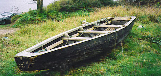
The Prong is the local boat which has been used by fishermen from the village. The first one built in many years is pictured below, together with an example of an older boat. The coastal communities are endeavouring to maintain their maritime heritage. So should the nation.

JOHNGOSSIPCHEEKPOINTPRONG

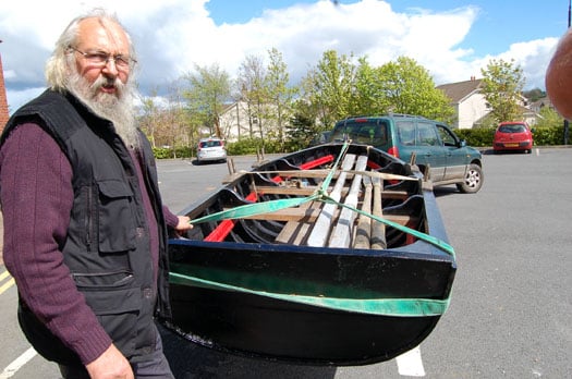
Above John Gossip with the new Cheekpoint Prong and below an older example of the craft

OLDER EXAMPLEOFCHEEKPOINTPRONG


Twitter: @TomMacSweeney

Published in Island Nation

#CRUISE CALLS – Waterford is to welcome its first cruise caller in 2012 with the Quest (1992/1,180grt) an ice-strengthened expedition cruiseship which is to dock next month along the city-quays, writes Jehan Ashmore.

Normally she operates around the Scottish Isles, Norway, Greenland and Spitsbergen. This year she will make her itineraries for the first time around Ireland, England and Wales.

The stout looking Danish built vessel is just 50m in length, has a beam of 11m and draws 3.5m, this allows her to reach more destinations in difficult conditions. She carries around 50 passengers and a crew half that number. For images including interiors and deck plans click HERE

Quest is also scheduled to make a second call to the south-east city in May. Following both these calls another 17 cruise callers are lined up for the season which runs until September.

Among the callers are the 940 passenger capacity Crystal Symphony, the 66,000 tonnes Marina which only entered service last year, Ocean Princess (for a dry-dock slideshow click HERE) and the 1988 built Prinsendam.

Depending on the vessel's draught, the location of where they will call in Waterford estuary will vary. Aside the city quays, the other berth is in Belview and for deep drafted vessels, they take anchorage off Dunmore East. To view the full cruise call list click HERE.

Published in Cruise Liners

#PORTS & SHIPPING- Berthed at the Steam Packet Quay, Drogheda is the suction-trailer dredger Lough Foyle (1979/868grt) which is on contract work with the Drogheda Port Company, writes Jehan Ashmore.

Following the sale last month of Hebble Sand, as previously reported on Afloat.ie (clcik HERE), the Lough Foyle (PHOTO) is now the only port-owned dredger on the island of Ireland. The Londonderry Port & Harbour Commissioners (LPHC) purchased the vessel from Dutch interests in 2009. She was originally the Saeftinge, built in 1979 at the Van Goor Scheepswerf in Monnickendam.

Since her introduction she has performed previous dredging operations to include the Drogheda Bar leading into the Co. Louth port. Her most recent contract was in Waterford Estuary, from where she arrived from on Tuesday after an overnight voyage.

In addition she has worked at the new Stena Line ferryport terminal at Loch Ryan, Cairnryan, to see related report click HERE. The Scottish ferryport is due to be officially opened tomorrow, to read more including the newly introduced 'Superfast' sisters click HERE.

Published in Ports & Shipping
As the cruise season draws to a close, passengers from the German 28,856 tonnes Amadea, visited Bantry Bay, west Cork today, writes Jehan Ashmore.
The former Japanese cruiseship launched in 1991, anchored off picturesque Glengariff and neighbouring Garinish Island. Amadea had called to Waterford Estuary yesterday and before her first Irish port of call she called to Dartmouth en-route from embarking passengers in Bremerhaven.

At 192m in length, the 600-passenger capacity cruiseship is operated by Pheonix Reisen. The German based travel agency also runs fleetmates Albratross and Artania. The later Finish built vessel was best known as Princess Cruises Royal Princess, when launched by the late Diana, Princess of Wales in 1984.

Apart from the handful of cruiseships that call, Bantry Bay is otherwise used by oil tankers bringing supplies to the Whiddy Island Oil Terminal. The terminal consists of an offshore single point mooring, tanker Jetty, and an onshore tank farm. The bay runs some 35kms long and is 10km wide at its broadest at the entrance and steadily narrows to 3-4kms at its head. In addition the bay is largest of the main inlets in the south-west.

Glengariff in recent years has also welcomed another German operator, Peter Deilmann's Deutschland (1988/22,496grt) and the UK based Cruise & Maritime Voyages Marco Polo (1966/20,080grt). To read more on this vessel which regularly calls to Irish ports click HERE.

Published in Cruise Liners

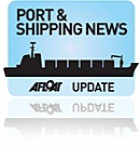
As the Russian 'A' class Mir passed the LE Aoife off Dunmore East in mid-morning, the largest tall ship of the festival headed the start of the Parade of Sail, writes Jehan Ashmore.

Crowds left their cars in fields outside Dunmore East and descended into the harbour and surrounding headlands to witness the highlight of the four-day festival. Adding to the scene were the numerous leisure-craft, yachts and intrepid kayakers that gathered to greet the procession which took some two hours to pass the fishing harbour.

No sooner had the fully-rigged ship Mir had slipped beyond the anchored naval vessel that the gaff schooner Johanna Lucretia, under full sail came closer into view. She was closely followed by the Ocean Youth Trust Scotland's Bermudan cutter Alba Explorer.

Mir

The Russian 'A' class Mir passing the LE Aoife off Dunmore East. Photo: Jehan Ashmore

Of all the 45 tallships participating the Columbian Navy's barque ARC Gloria presented the most colourful entrant. She proudly flew a large horizontal tricolor of yellow, blue and red representing the South American nation.

When it came to the turn of the Europa to pass the LE Aoife, the tug Bargarth gave a wonderful send-off with the traditional display of water jets shooting sky-high, nearly reaching the top of the three-masted barque.

Marking the tail-end of the parade was the Jubilee Sailing Trust's Lord Nelson, another barque that departed the estuary with the Hook Head Lighthouse forming a majestic backdrop.

At this stage several of the large tallships could be seen on the far horizon in preperation to the start of the first race leg of this years Tall Ships Races....next port of call Greenock!

More Tall Ships Photos

Dublin Hosts Tall Ships in 2012

View Waterford's Parade of Sail Photo Gallery Here

Published in Tall Ships
Amongst the festival tallships lining Waterford quays, the RV Keary, a marine research survey vessel that mapped the estuary in advance of the tall ships arrival, will too be open to the public, writes Jehan Ashmore.
Work to map the navigational channel of Waterford Harbour's estuary was completed last month by the catamaran hulled craft that belongs to the Geological Survey of Ireland (GSI). Her smaller fleetmate the 7.5m RIB RV Geo carried-out work in the shallower areas along the river banks. For images of the seabed survey click HERE. The survey which had started in April was a joint research programme between (GSI) and the Marine Institute (MI).

This was the RV Keary's first INFOMAR survey leg of 2011 and it was also the first time that both vessels have worked in tandem. The mapping of the estuary was from an area just west of the city's Rice Bridge to the open sea at the mouth of Waterford Harbour.

The estuary was mapped before in 2007 using the Marine Institutes larger vessel the RV Celtic Voyager, which covered the harbour approaches from the 10m contour to greater depth offshore. Both RV Keary and RV Geo overlapped their coverage with this previous data, producing a comprehensive and seamless seabed map of the area.

RV Keary is constructed of marine grade aluminium and was custom built in 2008 for the (GSI) by Veecraft Marine of Capetown, South Africa.
The 15m craft with a draft of just 2m is equipped with an extensive range of highly sophisticated technology. She has an open working area at the aft-deck to conduct operations and is licensed to carry up to 12 personnel. For further vessel characteristics click HERE.

The 34-tonne craft made her 7,000 mile delivery voyage from the African continent to Europe. She was firstly transported on the deck of a cargoship to Rotterdam. After unloading at the Dutch port the 22-knot capable craft set off with several calls along the UK south coast to include loading bunkers before finally reaching Dun Laoghaire, from where she entered service in April 2009.

Published in Marine Science

As the Tall Ship STS Lord Nelson nears Carnsore Point off Wexford this evening the barque will be one of the many vessels participating in the Waterford Talls Ships Races Festival, writes Jehan Ashmore.

Lord Nelson is the 'flagship' of the Jubilee Sailing Trust (JST) and is one of 13 'A' class tall-ships to enter the four-day festival which starts tomorrow. Notably she is only one of two tall ships in the world designed and built to enable people of all physical abilities to sail side-by-side as equals. On board the 55m three-masted sail-training ship are 11 crew and 39 trainees.

Joining Lord Nelson are three other UK entrants, they are the Jean de la Lune, Pelican of London and Royalist now celebrating her 40th anniversary. Together these tallships belong to the 'A' class vessels, the largest of the tallships. The impressive array of A class vessels includes four ships alone from The Netherlands with the Astrid, Eendracht, Europa and Wylde Swan, a schooner built in 1920.

From Norway is the fully rigged tallship Christian Radich and Sorlandet. The Poles are coming with their Pogoria. Neighbouring Russia are sending their impressive 108m long Mir which has 26 sails and has a 200-strong crew though the 1987 built vessel can be sailed with just 30. The final A class entrant is from outside Europe, the Columbian 1,300 tonnes Gloria, a three-master of over 60 metres long.

In addition to this exciting line-up are the 'B' and 'C' class which in total brings 45 tallships of all shapes and sizes to the quays of the River Suir. The crystal city will be host to over 1,000 trainess and over 400 professional crew who will take part in the colourful 'Crew Parade' held on Friday. For a full list of tallships and accompanying photos go to www.waterfordtallshipsrace.ie/the-race/the-tall-ships/

The spectacle of the festival will culminate in the early hours of Sunday when the fleet departs the city and heads downriver with a 'Parade of Sail' in the estuary of Waterford Harbour. As the tallships pass offshore of Dunmore East, this will mark the start of the first race-leg to Greenock.

The famous race is organised by Sail Training International (STI) a charity established to harness sail training to develop and educate young people, regardless of nationality, culture, religion, gender or social background.

The STI can trace its roots with the creation of the Sail Training International Race Committee which organised the first race of sail training tall ships in 1956. Their website is www.sailtraininginternational.org/

Published in Tall Ships
There are now only 100-days to the countdown of the Waterford Tall Ships Festival which is sailing into Irish waters at the end of June, writes Jehan Ashmore.
The four-day festival starting on 30 June returns to the south-eastern city which hosted the prestigious event in 2005. This year the maritime spectacle
is to draw 500,000 visitors from home and abroad. The festival is to be presented by Szczecin and organised by the Sail Training International.

Over 70 of the worlds tall-ships of all shapes and sizes will sail up the River Suir to take up residence on both sides of Waterford's city centre quays, where a major meeting of over 1,500 trainee sailors stretching from far and distant shores are to congregate.

One of the attending Class 'A' fully rigged ships, Christian Radich, which was built in 1937, incidentally provided sail-training opportunities for Irish trainees in an arrangement between her Norwegian owners and Coiste an Asgard. The sail-trainee agreement in 2009 followed the sinking of Coiste an Asgard's brigantine the Asgard II in the previous year. This was to be the last season of the state-owned sail training agency which was axed in the 2009 budget.

Another 'A' lister is the UK flagged Royalist, a brig built by Groves and Gutteridge in Cowes, Isle of Wight to a design by Colin Mudie. The 40 year old brig was named by HRH Princess Anne in 1971 for the Sea Cadet Association. She may be small for an 'A' class at just 28-metres long but the vessel can easily be spotted with her distinctive black and white painted hull.

While one of the oldest vessels to participant is the 87 year-old Brixham built trawler Provident, which along with Leader, are the only 'sailing' survivors of a once numerous traditional North Sea fishing craft. The 95-foot vessel was built at Galmpton on the River Dart. In 1991 there was a major refit of the 85 tonnes craft which has since 1999 worked from Brixham as part of the Trinity Sailing Foundation.

The event which is billed as the largest Irish festival in 2011 also presents young Irish people to experience a once in a lifetime opportunity to set sail onboard a tall-ship. The opportunity is open to those aged 16 or over by June 30 and are fit and active to be a trainee on the inaugural race leg from Waterford to Greenock (departing 3 July). For details click here.

On this date the eagerly awaited 'Parade of Sail' is set to depart the crystal city downriver on the Waterford Estuary and out into the open sea.

Looking for further reading on Tall Ships in Ireland? Click the links below:

Click this link to read all our Tall Ships Stories on one handy page


Previewing Ireland's Tall Ships 2011 Season


Can Ireland Get a New Tall Ship?

Published in Tall Ships
Bryan Ferry one of the UK's most influential pop artists of the last four decades, has been announced as the headline act for the opening night of the Waterford Tall Ships Races, one of the biggest sailing event of the year, which takes place on 30 June, writes Jehan Ashmore.
The solo-artist has enjoyed international success and through his band 'Roxy Music' with classic hits to include Love is the Drug, Slave to Love, Avalon; More Than This and Don't Stop the Dance.

Looking ahead to the Waterford show, Bryan Ferry said,' I am delighted to be returning to perform in Ireland following Roxy Music's performance at
Electric Picnic last year'.

Ferry will perform on the festival's main stage at Bolton Street. On the same site of the following night, The Waterboys will be supported by Waterford's O Emperor. While on the 2 July the headline act will be the Sharon Shannon Show with special guests Damien Dempsey and Dessie O'Halloran.

The four-day maritime spectacle which runs to 3 July is set to host over 70 tallships, over 1,500 trainee sailors and an anticipated 500,000 visitors that are to throng the 'Noblest Quays in Europe' with the countdown to the festival edging closer to just 100 days.

Billed as the largest Irish festival event in 2011, the return of the Tall Ships for the second time to Ireland's oldest city, presents young Irish people to experience a once in a lifetime opportunity to set sail onboard a tall-ship.

The opportunity is open to those aged 16 or over by June 30, 2011 and are fit and active to be a trainee on the inaugural race leg from Waterford to Greenock (departing 3 July). For further information click here.

The festival is not just eagerly awaited by fans of all things maritime and musical but with a programme that is also to feature street theatre, culinary and craftwork 'villages' and firework displays.

Renowned street theatre company 'Spraoi' have commissioned almost 20 national and international street performance acts. In addition the award-winning illusionist, Keith Barry will perform another specially-commissioned piece at the launch on the afternoon of 30 June.

On the nautical front, highlights include the 'Crew Parade' on 1 July and ultimately culminating with the 'Parade of Sail' by the international fleet on 3 July. Asides the city quayside on the River Suir the Waterford estuary provides excellent viewing points, some at elevated sites.

Looking for further reading on Tall Ships in Ireland? Click the links below:

Click this link to read all our Tall Ships Stories on one handy page


Previewing Ireland's Tall Ships 2011 Season


Can Ireland Get a New Tall Ship?

Published in Tall Ships
Tourist anglers spent €89.9 million in Ireland in 2008, a marine leisure conference in Co Waterford heard recently.
The importance of angling to the Irish economy was highlighted at the Rising Tide seminar in New Ross, an event focused on developing historical connections between Ireland and Newfoundland in Canada in the areas of fisheries, development and coastal tourism.
Speakers noted the "strong maritime tradition" along the south-east coast, the potential of the Waterford Estuary as a gateway to the inland waterways, and opportunities for development along the coast to tie in with next year's visit of the Tall Ships.
Minister of State for Fisheries, Sean Connick TD, also announced funding of €156,000 for Wexford harbours in tandem with Wexford County Council's allocation of €52,000.
The Irish Times has more on the story HERE.

Tourist anglers spent €89.9 million in Ireland in 2008, a marine leisure conference in Co Waterford heard recently.

The importance of angling to the economy was highlighted at the Rising Tide seminar in New Ross, an event focused on developing historical connections between Ireland and Newfoundland in Canada in the areas of fisheries, development and coastal tourism.

Speakers noted the "strong maritime tradition" along the south-east coast, the potential of the Waterford Estuary as a gateway to the region's inland waterways, and opportunities for development to tie in with next year's visit of the Tall Ships.

Minister of State for Fisheries, Sean Connick TD, also announced funding of €156,000 for Wexford harbours in tandem with Wexford County Council's allocation of €52,000.

The Irish Times has more on the story HERE.

Published in Aquatic Tourism
Page 2 of 3

General Information on using Waterways Ireland inland navigations

Safety on the Water

All users of the navigations are strongly recommended to make themselves aware of safety on the water for whatever activity they are involved in and to read the advice offered by the various governing bodies and by:

The Dept. of Transport, Ireland: www.gov.ie/transport and The Maritime and Coastguard Agency, UK, The RNLI – Water Safety Ireland for information in terms of drowning prevention and water safety.

Registration of Vessels

All vessels using the Shannon Navigation, which includes the Shannon-Erne Waterways and the Erne System must be registered with Waterways Ireland. Only open undecked boats with an engine of 15 horsepower or less on the Shannon Navigation, and vessels of 10 horsepower or less on the Erne System, are exempt. Registration is free of charge.

Craft registration should be completed online at: https://www.waterwaysireland.org/online-services/craft-registration

Permits for use of the Grand and Royal Canals and the Barrow Navigation

All vessels using the Grand and Royal Canals and the Barrow Navigation must display appropriate valid Permit(s) i.e A Combined Mooring and Passage Permit (€126) and if not intending to move every five days, an Extended Mooring Permit (€152).

Permit applications should be completed online at: https://www.waterwaysireland.org/online-services/canal-permits

Passage on the Royal and Grand Canals – Dublin Area

For boat passage through the locks east of Lock 12 into / out of Dublin on either the Royal or Grand Canals, Masters are requested to contact the Waterways Ireland Eastern Regional Office (M-F 9.30am-4.30pm) on tel: +353(0)1 868 0148 or email [email protected] prior to making passage in order to plan the necessary lock-keeping assistance arrangements.

On the Grand Canal a minimum of two days notice prior to the planned passage should be given, masters should note that with the exception of pre-arranged events, a maximum of 2 boats per day will be taken through the locks, travelling either east or west.

Movements in or out of the city will be organised by prior arrangement to take place as a single movement in one day. Boaters will be facilitated to travel the system if their passage is considered to be safe by Waterways Ireland and they have the valid permit(s) for mooring and passage.

Newcomen Lifting Bridge

On the Royal Canal two weeks’ notice of bridge passage (Newcomen Lifting Bridge) is required for the pre-set lift date, and lock assistance will then also be arranged. A minimum of 2 boats is required for a bridge lift to go ahead.

Waterways Ireland Eastern Regional Office (Tel: +353(0)1 868 0148 or [email protected] ) is the point of contact for the bridge lift.

A maximum number of boats passing will be implemented to keep to the times given above for the planned lifts (16 for the Sat / Sun lifts & 8 for the weekday lifts). Priority will be given on a first come first served basis.

On day of lift, boaters and passengers must follow guidance from Waterways Ireland staff about sequence of passage under bridge & through Lock 1, and must remain within signed and designated areas.

Events Held on the Waterways

All organised events taking place on the waterways must have the prior approval of Waterways Ireland. This is a twelve week process and application forms must be accompanied with the appropriate insurance, signed indemnity and risk assessment. The application should be completed on the Waterways Ireland events page at :

https://www.waterwaysireland.org/online-services/event-approval

Time Limits on Mooring in Public Harbours

On the Shannon Navigation and the Shannon-Erne Waterway craft may berth in public harbours for five consecutive days or a total of seven days in any one month.

On the Erne System, revised Bye Laws state that: No master or owner shall permit a vessel, boat or any floating or sunken object to remain moored at or in the vicinity of any public mooring, including mooring at any other public mooring within 3 kilometres of that location, for more than 3 consecutive days and shall not moor at that same mooring or any other public mooring within 3 kilometres of that location within the following 3 consecutive days without prior permission by an authorised official.

Winter Mooring on the Shannon Navigation and Shannon Erne Waterway

Winter mooring may be availed of by owners during the period 1 Nov to 31 Mar by prior arrangement and payment of a charge of €63.50 per craft. Craft not availing of Winter Mooring must continue to comply with the “5 Day Rule”. Winter Mooring applications should be completed online at : https://www.waterwaysireland.org/online-services/winter-moorings-booking

Owners should be aware that electricity supply and water supply to public moorings is disconnected for the winter months. This is to protect against frost damage, to reduce running costs and to minimise maintenance requirements during the winter months.

Vessel owners are advised that advance purchasing of electricity on the power bollards leading up to the disconnection date should be minimal. Electricity credit existing on the bollards will not be recoverable after the winter decommissioning date. Both services will be reinstated prior to the commencement of the next boating season.

Smart Cards

Waterways Ireland smart cards are used to operate locks on the Shannon Erne Waterway, to access the service blocks, to use the pump-outs along the navigations, to avail of electrical power at Waterways Ireland jetties.

Berthing in Public Harbours

Masters are reminded of the following:

  • Equip their vessel with mooring lines of appropriate length and strength and only secure their craft to mooring bollards and cleats provided for this purpose.
  • Ensure the available berth is suitable to the length of your vessel, do not overhang the mooring especially on finger moorings on floating pontoon moorings.
  • Ensure mooring lines, electric cables and fresh water hoses do not create a trip hazard on public jetties for others users.
  • Carry sufficient fenders to prevent damage to your own vessel, other vessels and WI property.
  • Allow sufficient space between your vessel and the vessel ahead /astern (c.1m) for fire safety purposes and /or to recover somebody from the water.
  • Do not berth more than two vessels side by side and ensure there is safe access/egress at all times between vessels and onto the harbour itself.
  • Do not berth in such a way to prevent use of harbour safety ladders, slipways or pump-outs.
  • Do not allow the bow of your vessel to overhang the walkway of a floating mooring thus creating a hazard for others with an overhanging anchor or bow fendering.
  • Animals are not allowed to be loose or stray at any time.
  • Harbour and jetty infrastructure such as railings, power pedestals, fresh water taps, electric light poles, safety bollards, ladders etc are not designed for the purpose of mooring craft , they will not bear the strain of a vessel and will be damaged.
  • At Carrybridge on the Erne System, Masters of vessels are not permitted to use stern on mooring. Masters of vessels must use the mooring fingers for mooring of vessels and for embarkation / disembarkation from vessels.

Passenger Vessel Berths

Masters of vessels should not berth on passenger vessel berths where it is indicated that an arrival is imminent. Passenger vessels plying the navigations generally only occupy the berths to embark and disembark passengers and rarely remain on the berths for extended periods or overnight.

Lock Lead-in Jetties

Lead-in jetties adjacent to the upstream and downstream gates at lock chambers are solely for the purpose of craft waiting to use the lock and should not be used for long term berthing.

Vessel Wake

Vessel wake, that is, the wave generated by the passage of the boat through the water, can sometimes be large, powerful and destructive depending on the hull shape and engine power of the vessel. This wake can be detrimental to other users of the navigation when it strikes their craft or inundates the shoreline or riverbank. Masters are requested to frequently look behind and check the effect of their wake / wash particularly when passing moored vessels, on entering harbours and approaching jetties and to be aware of people pursuing other activities such as fishing on the riverbank.

Speed Restriction

A vessel or boat shall not be navigated on the Shannon Navigation at a speed in excess of 5 kph when within 200 metres of a bridge, quay, jetty or wharf, when in a harbour or canal or when passing within 100 metres of a moored vessel or boat.

Vessels navigating the Shannon-Erne Waterway should observe the general 5 kph speed limit which applies along the waterway. This is necessary in order to prevent damage to the banks caused by excessive wash from vessels.

Vessels navigating the Erne System should observe the statutory 5kt / 6mph / 10kph speed limit areas.

A craft on the Royal and Grand canals shall not be navigated at a speed in excess of 6km per hour.

A craft on the Barrow Navigation shall not be navigated at a speed in excess of 11km per hour except as necessary for safe navigation in conditions of fast flow.

Bank Erosion

Narrow sections of all the navigations are particularly prone to bank erosion due to the large wash generated by some craft. Masters are requested to be vigilant and to slow down to a speed sufficient to maintain steerage when they observe the wash of their craft inundating the river banks.

Unusual Waterborne Activity

Unusual waterborne vessels may be encountered from time to time, such as, hovercraft or amphibious aircraft / seaplanes. Masters of such craft are reminded to apply the normal “Rule of the Road” when they meet conventional craft on the water and to allow extra room to manoeuvre in the interest of safety.

Sailing Activity

Mariners will encounter large numbers of sailing dinghies from late June to August in the vicinity of Lough Derg, Lough Ree and Lower Lough Erne. Sailing courses are marked by yellow buoys to suit weather conditions on the day. Vessels should proceed at slow speed and with due caution and observe the rules of navigation when passing these fleets, as many of the participants are junior sailors under training.

Rowing

Mariners should expect to meet canoes and vessels under oars on any part of the navigations, but more so in the vicinity of Athlone, Carrick-on-Shannon, Coleraine, Enniskillen and Limerick. Masters are reminded to proceed at slow speed and especially to reduce their wash to a minimum when passing these craft as they can be easily upset and swamped due to their very low freeboard and always be prepared to give way in any given traffic situation.

Canoeing

Canoeing is an adventure sport and participants are strongly recommended to seek the advice of the sport’s governing bodies i.e Canoeing Ireland and the Canoe Association of Northern Ireland, before venturing onto the navigations.

Persons in charge of canoes are reminded of the inherent danger to these craft associated with operating close to weirs, sluice gates, locks and other infrastructure particularly when rivers are in flood and large volumes of water are moving through the navigations due to general flood conditions or very heavy localised precipitation e.g. turbulent and broken water, stopper waves. Shooting weirs is prohibited without prior permission of Waterways Ireland.

Canoeists should check with lockkeepers prior entering a lock to ensure passage is done in a safe manner. Portage is required at all unmanned locks.

Canoe Trail Network – "Blueways"

Masters of powered craft are reminded that a canoe trail network is being developed across all navigations and to expect more organised canoeing along these trails necessitating slow speed and minimum wash when encountering canoeists, rowing boats etc

Rockingham and Drummans Island Canals – Lough Key

It is expected that work on Rockingham and Drummans Island Canals on Lough Key will be completed in 2021. Access to these canals will be for non-powered craft only, eg canoes, kayaks, rowing boats.

Fast Powerboats and Personal Watercraft (Jet Skis)

Masters of Fast Powerboats (speed greater than 17kts) and Personal Watercraft (i.e.Jet Skis) are reminded of the inherent dangers associated with high speed on the water and especially in the confines of small bays and narrow sections of the navigations. Keeping a proper look-out, making early alterations to course and /or reducing speed will avoid conflict with slower vessels using the navigation. Personal Watercraft are not permitted to be used on the canals.

Towing Waterskiers, Wakeboarders, Doughnuts etc

Masters of vessels engaged in any of these activities are reminded of the manoeuvring constraints imposed upon their vessel by the tow and of the added responsibilities that they have to the person(s) being towed. These activities should be conducted in areas which are clear of conflicting traffic. It is highly recommended that a person additional to the master be carried to act as a “look-out” to keep the tow under observation at all times.

Prohibition on Swimming

Swimming in the navigable channel, particularly at bridges, is dangerous and is prohibited due to the risk of being run over by a vessel underway in the navigation.

Age Restrictions on operating of powered craft

In the Republic of Ireland, Statutory Instrument 921 of 2005 provides the legal requirements regarding the minimum age for operating of powered craft. The Statutory Instrument contains the following requirements:

- The master or owner of a personal watercraft or a fast power craft shall take all reasonable steps to ensure that a person who has not attained the age of 16 years does not operate or control the craft

- The master or owner of a pleasure craft powered by an engine with a rating of more than 5 horse power or 3.7 kilowatts shall take all reasonable steps to ensure that a person who has not attained the age of 12 years does not operate or control the craft.

Lifejackets and Personal Flotation Devices (PFDs)

Lifejackets and PFD’s are the single most important items of personal protective equipment to be used on a vessel and should be worn especially when the vessel is being manoeuvred such as entering / departing a lock, anchoring, coming alongside or departing a jetty or quayside.

In the Republic of Ireland, Statutory Instrument 921 of 2005 provides the legal requirements regarding the wearing of Personal Flotation Devices. The Statutory Instrument contains the following requirements:

- The master or owner of a pleasure craft (other than a personal watercraft) shall ensure, that there are, at all times on board the craft, sufficient suitable personal flotation devices for each person on board.

- A person on a pleasure craft (other than a personal watercraft) of less than 7 metres length overall shall wear a suitable personal flotation device while on board an open craft or while on the deck of decked craft, other than when the craft is made fast to the shore or at anchor.

- The master or owner of a pleasure craft (other than a personal watercraft) shall take all reasonable steps to ensure that a person who has not attained the age of 16 years complies with paragraph above.

- The master or owner of a pleasure craft (other than a personal watercraft), shall take all reasonable steps to ensure that a person who has not attained the age of 16 years wears a suitable personal flotation device while on board an open craft or while on the deck of a decked craft other than when it is made fast to the shore or at anchor.

- The master or owner of a pleasure craft (other than a personal watercraft) shall take all reasonable steps to ensure that a person wears a suitable personal flotation device, at all times while – (a) being towed by the craft, (b) on board a vessel or object of any kind which is being towed by the craft.

Further information is available at: http://www.irishstatutebook.ie/eli/2005/si/921/made/en/print

Firing Range Danger Area – Lough Ree

The attention of mariners is drawn to the Irish Defence Forces Firing Range situated in the vicinity of buoys No’s 2 and 3, on Lough Ree on the Shannon Navigation. This range is used regularly for live firing exercises, throughout the year, all boats and vessels should stay clear of the area marked with yellow buoys showing a yellow "X" topmark and displaying the word "Danger".

Shannon Navigation, Portumna Swing Bridge Tolls

No attempt should be made by Masters’ of vessels to pay the bridge toll while making way through the bridge opening. Payment will only be taken by the Collector from Masters when they are secured alongside the jetties north and south of the bridge.

Navigating from Killaloe to Limerick on the Shannon Navigation

The navigation from Killaloe to Limerick involves passage through Ardnacrusha locks, the associated headrace and tailrace and the Abbey River into Limerick City. Careful passage planning is required to undertake this voyage. Considerations include: lock passage at Ardnacrusha, water flow in the navigation, airdraft under bridges on Abbey River in Limerick, state of tide in Limerick

Users are advised to contact the ESB Ardnacrusha hydroelectric power station (00353 (0)87 9970131) 48 hours in advance of commencing their journey to book passage through the locks at Ardnacrusha. It is NOT advised to undertake a voyage if more than one turbine is operating (20MW), due to the increased velocity of flow in the navigation channel, which can be dangerous. To ascertain automatically in real time how many turbines are running, users can phone +353 (0)87 6477229.

For safety reasons the ESB has advised that only powered craft with a capacity in excess of 5 knots are allowed to enter Ardnacrusha Headrace and Tailrace Canals.

Passage through Sarsfield Lock should be booked on +353-87-7972998, on the day prior to travel and it should be noted also that transit is not possible two hours either side of low water.

A Hydrographic survey in 2020 of the navigation channel revealed that the approach from Shannon Bridge to Sarsfield Lock and the Dock area has silted up. Masters of vessels and water users are advised to navigate to the Lock from Shannon bridge on a rising tide one or two hours before High Tide.

Lower Bann Navigation

The attention of all users is drawn to the “Users Code for the Lower Bann”, in particular to that section covering “Flow in the River” outlining the dangers for users both on the banks and in the navigation, associated with high flow rates when the river is in spate. Canoeists should consult and carry a copy of the “Lower Bann Canoe Trail” guide issued by the Canoe Association of Northern Ireland. Users should also contact the DfI Rivers Coleraine, who is responsible for regulating the flow rates on the river, for advisory information on the flow rates to be expected on any given day.

DfI Rivers Coleraine. Tel: 0044 28 7034 2357 Email: [email protected]

Lower Bann Navigation – Newferry – No wake zone

A No Wake Zone exists on the Lower Bann Navigation at Newferry. Masters of vessels are requested to proceed at a slow speed and create no wake while passing the jetties and slipways at Newferry.

Overhead Power Lines (OHPL) and Air draft

All Masters must be aware of the dangers associated with overhead power lines, in particular sailing vessels and workboats with cranes or large air drafts. Voyage planning is a necessity in order to identify the location of overhead lines crossing the navigation.

Overhead power line heights on the River Shannon are maintained at 12.6metres (40 feet) from Normal Summer level for that section of navigation, masters of vessels with a large air draft should proceed with caution and make additional allowances when water levels are high.

If a vessel or its equipment comes into contact with an OHPL the operator should NOT attempt to move the vessel or equipment. The conductor may still be alive or re-energise automatically. Maintain a safe distance and prevent third parties from approaching due to risk of arcing. Contact the emergency services for assistance.

Anglers are also reminded that a minimum ground distance of 30 metres should be maintained from overhead power lines when using a rod and line.

Submarine Cables and Pipes

Masters of vessels are reminded not to anchor their vessels in the vicinity of submarine cables or pipes in case they foul their anchor or damage the cables or pipes. Look to the river banks for signage indicating their presence.

Water Levels - Precautions

Low Water Levels:

When water levels fall below normal summer levels masters should be aware of:

Navigation

To reduce the risk of grounding masters should navigate on or near the centreline of the channel, avoid short cutting in dog-legged channels and navigating too close to navigation markers.

Proceeding at a slow speed will also reduce “squat” effect i.e. where the vessel tends to sit lower in the water as a consequence of higher speed.

Slipways

Reduced slipway length available under the water surface and the possibility of launching trailers dropping off the end of the concrete apron.

More slipway surface susceptible to weed growth requiring care while engaged in launching boats, from slipping and sliding on the slope. Note also that launching vehicles may not be able to get sufficient traction on the slipway once the craft is launched to get up the incline.

Bank Erosion

Very dry riverbanks are more susceptible to erosion from vessel wash.

Lock Share

Maximising on the number of vessels in a lock will ensure that the total volume of water moving downstream is decreased. Lock cycles should be used for vessels travelling each way.

High Water Levels:

When water levels rise above normal summer level masters should be aware of:

Navigation

Navigation marks will have reduced height above the water level or may disappear underwater altogether making the navigable channel difficult to discern.

In narrow sections of the navigations water levels will tend to rise more quickly than in main streams and air draft at bridges will likewise be reduced.

There will also be increased flow rates particularly in the vicinity of navigation infrastructure such as bridges, weirs, locks etc where extra care in manoeuvring vessels will be required.

Harbours and Jetties

Due care is required in harbours and at slipways when levels are at or near the same level as the harbour walkways' as the edge will be difficult to discern especially in reduced light conditions. It is advised that Personal Flotation Devices be worn if tending to craft in a harbour in these conditions.

Slipways

Slipways should only be used for the purpose of launching and recovering of water craft or other objects from the water. Before using a slipway it should be examined to ensure that the surface has sufficient traction/grip for the intended purpose such as launching a craft from a trailer using a vehicle, that there is sufficient depth of water on the slipway to float the craft off the trailer before the concrete apron ends and that the wheels of the trailer do not drop off the edge of the slipway. That life-saving appliances are available in the vicinity, that the vehicle is roadworthy and capable of coping with the weight of the trailer and boat on the incline. It is recommended that slipway operations are conducted by two persons.

Caution to be Used in Reliance upon Aids to Navigation

The aids to navigation depicted on the navigation guides comprise a system of fixed and floating aids to navigation. Prudent mariners will not rely solely on any single aid to navigation, particularly a floating aid to navigation. With respect to buoys, the buoy symbol is used to indicate the approximate position of the buoy body and the ground tackle which secures it to the lake or river bed. The approximate position is used because of the practical limitations in positioning and maintaining buoys in precise geographical locations. These limitations include, but are not limited to, prevailing atmospheric and lake/river conditions, the slope of and the material making up the lake/river bed, the fact that the buoys are moored to varying lengths of chain, and the fact that the buoy body and/or ground tackle positions are not under continuous surveillance. Due to the forces of nature, the position of the buoy body can be expected to shift inside and outside the charted symbol.

Buoys and perches are also moved out of position or pulled over by those mariners who use them to moor up to instead of anchoring. To this end, mariners should always monitor their passage by relating buoy/perch positions with the published navigation guide. Furthermore, a vessel attempting to pass close by always risks collision with a yawing buoy or with the obstruction that the buoy or beacon/perch marks.

Masters of Vessels are requested to use the most up to date Navigation guides when navigating on the Inland Waterways.

Information taken from Special Marine Notice No 1 of 2023