Menu

Ireland's sailing, boating & maritime magazine

A Harbour Seal photographed at Dun Laoghaire Marina on Dublin Bay, Ireland. Also known as the common seal, is a true seal found along temperate and Arctic marine coastlines of the Northern Hemisphere. The most widely distributed species of pinnipeds, they are found in coastal waters of the northern Atlantic and Pacific oceans, Baltic and North seas. Photo: AfloatA photograph of a Harbour Seal taken at Dun Laoghaire Marina on Dublin Bay, Ireland. Also known as the common seal, this species can be found along temperate and Arctic marine coastlines throughout the Northern Hemisphere. They are the most widely distributed species of pinnipeds and can be found in the coastal waters of the northern Atlantic and Pacific oceans, as well as the Baltic and North Seas. Photo: Afloat

Displaying items by tag: EastLink Toll Bridge

#EastLink@30 – Naval Service OPV L.E. Aisling (P23) took the honour of passing through Dublin's East-Link Toll Bridge as the Liffey road crossing celebrated opening to traffic 30 years ago today, writes Jehan Ashmore.

The final of the 'Emer' OPV class built sisters made the transit of the bridge built to a bascule design in which the 'lifting' span of 45 metres wide was raised. The opening span weighing 500 tons is tilted to 80 degrees and taking less than a minute to complete. This allowed the L.E Aisling to continue upriver to berth along Sir John Rogersons Quay.

When the bridge was opened on 21st October 1984, this created a new eastern by-pass of the capital however this was to be an end of era with the withdrawal of the Liffey ferry, albeit a foot-passenger only service.

The ferry was used as short cut mostly for 'dockers' as otherwise the next fixed link bridging the Liffey three decades ago was the Matt Talbot Memorial Bridge. This structure was close to where the last Guinness stout-ships berthed, The Lady Patricia and Miranda Guinness along Sir John Rogersons Quay.

The stout-tankers were the last ships to regularly transit the East-Link Bridge until 1993. They exported the 'black stuff' to Runcorn on the Manchester Ship Canal.

The East-Link Bridge has a strong commuter profile with approximately 17,500 vehicles daily using the bridge connecting the north and south quays. The bridge spanning 150 metres was the vision of Tom Roche (senior) founder of the National Toll Roads, the original operators of the tolled bridge.

Not only is the bridge used by car motorists but notably is a national strategic infrastructure asset for freight trucks to access the port. As the years passed with the opening of the Dublin Port Tunnel, this formed another key part of the overall port related road network and to further alleviate congestion away from the city-centre quays.

Another milestone in the infrastructure of bridging the Liffey was the Samuel Beckett Bridge which ironically itself made a transit through the East-Link Bridge. The structure was loaded on board a barge in The Netherlands and was towed to Dublin Port in 2009 for installation. The Samuel Beckett Bridge is of a swing-bridge design in which the whole bridge pivots on a single pier.

It was in May this year when another of the Naval Service's OPV's the newbuild L.E. Samuel Beckett (P61) moored close to the bridge also bearing the name of the playright as the vessel was christened along the south quays.

For a speeded up footage taken on board from the mast of the newbuild as she headed into Dublin Port and through the East-Link Bridge prior to her naming ceremony, click HERE.


Published in Coastal Notes

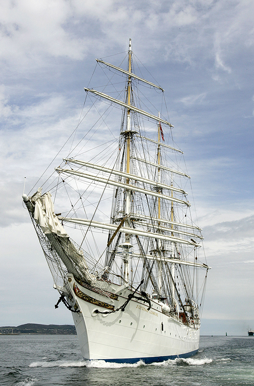
The arrival of the largest and oldest Norwegian tallship the barque S/S Statsraad Lehmkuhl into Dublin Port yesterday made for an impressive sight, even without her sails set, writes Jehan Ashmore.
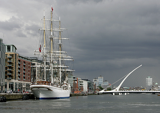
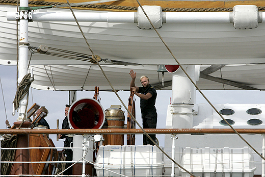
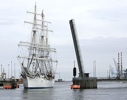
At nearly a century-old the square-rigged ship eased her way through the East-Link toll bridge where she proceeded to berth at Sir John Rogersons Quay, where she will be open to the public today between 12:00 – 16:30 and tomorrow,Saturday the 20th August from 10:00 –12:00. Her berth is downriver of the Samuel Beckett swing-bridge and the nearest DART stations are at Grand Canal Dock and Pearse St.
statsraad_1
Statsraad Lehmkuhl is 321-feet long and the barque is also one of the largest three-masted sailing ships in the world. The height from the water-line to the top of the mainmast is 240-feet and in total she carries 22 sails which cover an area of over 2,000 square metres. Under canvass she can achieve 18 knots or when under motor-power her 1,125hp diesel engine manages 11 knots. 
statsraad_2
As reported on Afloat.ie the steel-hulled barque departed her homeport of Bergen last week on a voyage across the North Sea to include a call to Stornoway on the Isle of Lewis. She was built in 1914 originally for the German Merchant Marine and at nearly a century-old she has had a colourful career having changed hands between Germany and Britain during both World Wars.
Since 1978 she has been with her current operators the Statsraad Lehmkuhl Foundation, based in the Nordic's country's second largest city. For further information about the 1,516-tonnes vessel specifications click HERE and interior illustration of deck layout click HERE.
statsraad_3

Her arrival marks nearly a year in advance to Dublin City welcoming the return of the Tall Ships Races, presented by Szczecin and organised by Sail Training International. The capital last hosted the event in 1998 and next year up to 100 tall ships are to sail into the capital which will be the final host port for four days between 23rd-26th August 2012.
statsraad_4

Tall Ship S/S Statsraad Lehmkuh in Dublin Bay yesterday. Images: Iain White

The celebration of sail is expected to draw entrants from as far away as Chile, Mexico, Argentina, USA and European and Baltic countries including Italy and Norway will chart their course to Dublin. It is hoped that the event will attract over a million visitors to the city, topping the 500,000 spectators who thronged the Waterford quays during this year's tall ship race gathering.
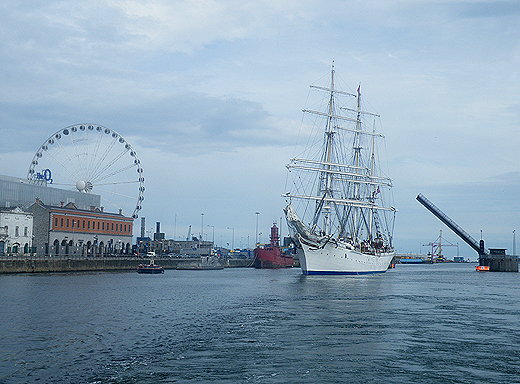
tallship_jehan

Photo: Jehan Ashmore

Published in Tall Ships
The public will have greater access to see shipping activity in the Port of Dublin, when a new boat-based tour of the country's busiest port starts tomorrow, writes Jehan Ashmore.
Titled the River Liffey & Port Tour, the 45-minute excursion is a partnership between Sea Safari Tours and the Dublin Port Company. Tours will operate from the pontoon where the M.V. Cill Airne floating river-restaurant and bar venue is berthed at the North Wall Quay. Cill Airne was built in the Liffey Dockyard nearly fifty years ago, where she forms part of the tours audio commentary covering the history and the present day.

In addition to cruising this stretch of the River Liffey alongside the 'Docklands' quarter, the tour RIB boat will pass downriver through the East-Link toll bridge where visitors will get closer views of the variety of vessels and calling cruise liners from other ports throughout the world.

There will be five daily tours beginning at 10.00am, 12.00pm, 2.00pm, 4.00pm and 6.00pm.Tickets cost €15.00 for adults, €12.50 for students and the charge for senior citizens and children is €10.00.

In addition Sea Safari operate a 'River Liffey' only tour, a Dublin Bay 'North' and 'South' tours which visit Howth Head, Baily Lighthouse, Ireland's Eye and to Dalkey Island and Killiney Bay, where both bay tours provide a chance to spot local marine wildlife of seals, porpoises and sea birds.

Published in Dublin Port
With sweeping lines the 54m private motor-yacht Fortunate Sun became the largest vessel to transit Dublin's Samuel Beckett swing-bridge, writes Jehan Ashmore.
The motoryacht (click PHOTO) which has luxurious accommodation for 10 guests and 12 crew had sailed from the Scottish western isles and made a lunchtime arrival on Wednesday, where the vessel initially docked at Ocean Pier, Dublin Port.

She remained alongside this berth which is normally used by large commercial ships until the vessel sought a berth much closer to the city-centre. This led to a shift of berths in the evening when the 2003 built vessel headed upriver to the Dublin City Moorings facility at Custom House Quay, but this firstly required transiting through two bridges.

With a beam of 10.6m Fortunate Sun entered through the East-Link toll-lift bridge followed by the Samuel Beckett bridge, the Liffey's newest crossing point which opened in late 2009. The €60m bridge was commissioned by Dublin City Council and designed by the Spanish architect engineer Santiago Calatrava. To read more on the bridge click HERE.

Fortunate Sun is registered in the Caymen Islands and is capable of over 17 knots on a range of 5000 nautical miles. She has a steel hull and an aluminium superstructure and interiors also by Tim Heywood Design. In the early hours of tomorrow morning the vessel built by Oceanfast is to depart through the 5,700 tonnes bridge which was delivered by barge after a five-day voyage from Rotterdam.

There has been previous transits of the bridge notably the annual Dublin Rally organised by the the Inland Waterways Association of Ireland (IWAI). This year's Dublin Rally took place on 1 May when boats travelling on the Royal Canal descended via Croke Park and entered the Liffey at Spencer Dock. This required the Iarnrod Éireann bridge-lift and the water level in Spencer Dock to be lowered so to allow safe clearance under the Sheriff St. bridge.

From there the IWAI flotilla made the short passage downriver to re-enter another inland waterway system at the Grand Canal Dock, marking where the Liffey connects with the city's southern canal. The 2011 Dublin Rally was the first time since 1955 that boats could enter Dublin from the Shannon via the Royal Canal and the first time since 2004 that boats also joined from the Royal Canal.

Published in Ports & Shipping
The Dublin Bay Old Gaffers Association (DBOG) continue with their lecture programme in the Poolbeg Yacht Boat Club & Marina (PYBC). The next lecture "The Circumnavigation – Continued " will be presented by Pat & Olivia Murphy and is to be held on Tuesday 5 April.
The lecture starts at 8 pm but the organisers are encouraging those wishing to attend to assemble at 7.15 pm for a socialable drink in advance.
Poolbeg clubhouse overlooks the marina and faces the entrance to Alexandra Basin, where shipping activities of the commercial port can be viewed in closer detail.
To reach the clubhouse which is located on the South Bank, Pigeon House Road, Ringsend, take the Sean Moore Road that connects the Merrion Strand Road (from the south) and the East-Link Toll Bridge (if travelling from the northside).

For further information on the lectures to date click this link and in general about the DBOGA logon here. To contact the PYBC Tel: (01) 668 9983 or logon to www.poolbegmarina.ie/

Published in Boating Fixtures
The next lecture organised by the Dublin Bay Old Gaffers Association (DBOG) will be "Diving The Wreck of the Bolivar on the Kish Bank" by Cormac Lowth. The lecture will take place in the Poolbeg Yacht Boat Club & Marina (PYBC) at 8pm on Tuesday 8 March.
The lecture will examine the story of the ship, the shipwreck, the re-discovery and diving and fishery. In addition many other shipwrecks dived by the speaker will be included and accompanied with illustrations.

The talks proper will begin at 8 pm but the organisers are encouraging those wishing to attend to assemble at 7.15 pm for a socialable drink in advance of the talk starting. All are welcome and the admission is free, noting a donation for the RNLI will be held at the door. For further information about the DBOGA logon to www.dublinbayoldgaffersassociation.com/

The Poolbeg yacht clubhouse is located on the South Bank, Pigeon House Road, Ringsend which can be accessed from the Sean Moore Road that connects the Merrion Strand Road (from the south) and the East-Link Toll Bridge (from the north). For information in general about the PYBC Tel: (01) 668 9983 or logon to www.poolbegmarina.ie/

Published in Boating Fixtures

For all you need on the Marine Environment - covering the latest news and updates on marine science and wildlife, weather and climate, power from the sea and Ireland's coastal regions and communities - the place to be is Afloat.ie.

Coastal Notes

The Coastal Notes category covers a broad range of stories, events and developments that have an impact on Ireland's coastal regions and communities, whose lives and livelihoods are directly linked with the sea and Ireland's coastal waters.

Topics covered in Coastal Notes can be as varied as the rare finding of sea-life creatures, an historic shipwreck with secrets to tell, or even a trawler's net caught hauling much more than just fish.

Other angles focusing the attention of Coastal Notes are Ireland's maritime museums, which are of national importance to maintaining access and knowledge of our nautical heritage, and those who harvest the sea using small boats based in harbours where infrastructure and safety pose an issue, plying their trade along the rugged wild western seaboard.

Coastal Notes tells the stories that are arguably as varied as the environment they come from, and which shape people's interaction with the natural world and our relationship with the sea.

Marine Wildlife

One of the greatest memories of any day spent boating around the Irish coast is an encounter with Marine Wildlife. It's a thrill for young and old to witness seabirds, seals, dolphins and whales right there in their own habitat. And as boaters fortunate enough to have experienced it will testify, even spotting a distant dorsal fin can be the highlight of any day afloat. Was that a porpoise? Was it a whale? No matter how brief the glimpse, it's a privilege to share the seas with Irish marine wildlife.

Thanks to our location in the North Atlantic, there appears to be no shortage of marine life to observe. From whales to dolphins, seals, sharks and other ocean animals, the Marine Wildlife category documents the most interesting accounts around our shores. And we're keen to receive your observations, your photos, links and video clips, too!

Also valuable is the unique perspective of all those who go afloat, from coastal sailing to sea angling to inshore kayaking to offshore yacht racing, as what they encounter can be of great importance to organisations such as the Irish Whale and Dolphin Group (IWDG). Thanks to their work we now know we share the seas with dozens of species who also call Ireland home. But as impressive as the list is, the experts believe there are still gaps in our knowledge. Next time you are out on the ocean waves, keep a sharp look out!

Weather

As an island in the North Atlantic, Ireland's fate is decided by Weather more so than many other European countries. When storm-force winds race across the Irish Sea, ferry and shipping services are cut off, disrupting our economy. When swollen waves crash on our shores, communities are flooded and fishermen brace for impact - both to their vessels and to their livelihoods.

Keeping abreast of the weather, therefore, is as important to leisure cruisers and fishing crews alike - for whom a small craft warning can mean the difference between life and death - as it is to the communities lining the coast, where timely weather alerts can help protect homes and lives.

Weather affects us all, and Afloat.ie will keep you informed on the hows and the whys.

Marine Science

Perhaps it's the work of the Irish research vessels RV Celtic Explorer and RV Celtic Voyager out in the Atlantic Ocean that best highlights the essential nature of Marine Science for the future growth of Ireland's emerging 'blue economy'.

From marine research to development and sustainable management, Ireland is developing a strong and well-deserved reputation as an emerging centre of excellence. Whether it's Wavebob ocean energy technology to aquaculture to weather buoys and oil exploration, the Marine Science category documents the work of Irish marine scientists and researchers and how they have secured prominent roles in many European and international marine science bodies.

Power From The Sea

The message from the experts is clear: offshore wind and wave energy is the future. And as Ireland looks towards the potential of the renewable energy sector, generating Power From The Sea will become a greater priority in the State's 'blue growth' strategy.

Developments and activities in existing and planned projects in the pipeline from the wind and wave renewables sector, and those of the energy exploration industry, point to the future of energy requirements for the whole world, not just in Ireland. And that's not to mention the supplementary industries that sea power projects can support in coastal communities.

Irish ports are already in a good position to capitalise on investments in offshore renewable energy services. And Power From The Sea can even be good for marine wildlife if done properly.

Aside from the green sector, our coastal waters also hold a wealth of oil and gas resources that numerous prospectors are hoping to exploit, even if people in coastal and island areas are as yet unsure of the potential benefits or pitfalls for their communities.

Changing Ocean Climate

Our ocean and climate are inextricably linked - the ocean plays a crucial role in the global climate system in a number of ways. These include absorbing excess heat from the atmosphere and absorbing 30 per cent of the carbon dioxide added to the atmosphere by human activity. But our marine ecosystems are coming under increasing pressure due to climate change.

The Marine Institute, with its national and international partners, works to observe and understand how our ocean is changing and analyses, models and projects the impacts of our changing oceans. Advice and forecasting projections of our changing oceans and climate are essential to create effective policies and management decisions to safeguard our ocean.

Dr Paul Connolly, CEO of the Marine Institute, said, “Our ocean is fundamental to life on earth and affects so many facets of our everyday activities. One of the greatest challenges we face as a society is that of our changing climate. The strong international collaborations that the Marine Institute has built up over decades facilitates a shared focusing on our changing ocean climate and developing new and enhanced ways of monitoring it and tracking changes over time.

“Our knowledge and services help us to observe these patterns of change and identify the steps to safeguard our marine ecosystems for future generations.”

The Marine Institute’s annual ocean climate research survey, which has been running since 2004, facilitates long term monitoring of the deep water environment to the west of Ireland. This repeat survey, which takes place on board RV Celtic Explorer, enables scientists to establish baseline oceanic conditions in Irish waters that can be used as a benchmark for future changes.

Scientists collect data on temperature, salinity, water currents, oxygen and carbon dioxide in the Atlantic Ocean. This high quality oceanographic data contributes to the Atlantic Ocean Observing System. Physical oceanographic data from the survey is submitted to the International Council for the Exploration of the Seas (ICES) and, in addition, the survey contributes to national research such as the VOCAB ocean acidification and biogeochemistry project, the ‘Clean Atlantic’ project on marine litter and the A4 marine climate change project.

Dr Caroline Cusack, who co-ordinates scientific activities on board the RV Celtic Explorer for the annual survey, said, “The generation of long-term series to monitor ocean climate is vital to allow us understand the likely impact of future changes in ocean climate on ecosystems and other marine resources.”

Other activities during the survey in 2019 included the deployment of oceanographic gliders, two Argo floats (Ireland’s contribution to EuroArgo) and four surface drifters (Interreg Atlantic Area Clean Atlantic project). The new Argo floats have the capacity to measure dissolved ocean and biogeochemical parameters from the ocean surface down to a depth of 2,000 metres continuously for up to four years, providing important information as to the health of our oceans.

During the 2019 survey, the RV Celtic Explorer retrieved a string of oceanographic sensors from the deep ocean at an adjacent subsurface moored station and deployed a replacement M6 weather buoy, as part of the Irish Marine Data Buoy Observation Network (IMDBON).

Funded by the Department of Agriculture, Food and the Marine, the IMDBON is managed by the Marine Institute in collaboration with Met Éireann and is designed to improve weather forecasts and safety at sea around Ireland. The data buoys have instruments which collect weather and ocean data including wind speed and direction, pressure, air and sea surface temperature and wave statistics. This data provides vital information for weather forecasts, shipping bulletins, gale and swell warnings as well as data for general public information and research.

“It is only in the last 20 years, meteorologists and climatologists have really began to understood the pivotal role the ocean plays in determining our climate and weather,” said Evelyn Cusack, Head of Forecasting at Met Éireann. “The real-time information provided by the Irish data buoy network is particularly important for our mariners and rescue services. The M6 data buoy in the Atlantic provides vital information on swell waves generated by Atlantic storms. Even though the weather and winds may be calm around our shores, there could be some very high swells coming in from Atlantic storms.”