


Displaying items by tag: Barrow Navigation
Online Applications For Mooring & Passage Canal Permits Now Open
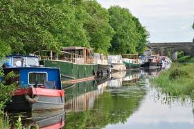
#InlandWaters - Combined mooring and passage permits and extended mooring permits for the Grand Canal, Royal Canal and Barrow Navigation for the 2019 season are now available online from Waterways Ireland.
All permits will run until Thursday 31 October, with annual renewal on 1 November each year. Applications require a photo of the vessel and a copy of its insurance (third party minimum).
Applicants can decide to print their own permit or have a hard copy sent by post. Submitted applications will receive an acknowledgement email, and once approved, an online link will be emailed for payment.
Questions regarding the application process can be forwarded to the inspectorate at [email protected] or by phone to 09064 35690 (9am-12pm Monday to Friday).

#byelaws – Waterways Ireland invites people and organisations affected by the changes to the Draft Canals Act, 1986(Amendment) Bye-Laws, 2014 to make submissions to Waterways Ireland before the 3rd February 2014.
All the documents are available online and can be viewed by arrangement in Waterways Ireland offices in Enniskillen and Dublin. Submissions can be made online, by email, by post and by visiting Waterways Ireland offices.
Submissions are being sought on changes to the Bye-Laws on the Grand Canal, Royal Canal and Barrow Navigation. The Draft Canals Act, 1986(Amendment), Bye-Laws, 2014 includes a new management framework which will be used to manage continuous cruising, houseboats, dry dock facilities as well as key location & serviced mooring usage. The amendments also include changes to mooring times, charges and the introduction of a fixed penalty notice.
Waterways Ireland will consult with the groups representing the views of people affected by statutory equality regulations such as disability or age based groups. In addition Waterways Ireland will be holding meetings with groups where their members will be affected by the changes to the Bye-Laws. Letters have also been issued to all permit holders on the navigations affected by the Bye-Law changes informing them of the public consultation and the availability of the documentation.
The period for submissions is set by the Section 7(1) of the Canals Act, 1986 (No.3 of 1986) as amended by section 56 of the Maritime Safety Act, 2005 (No. 11 of 2005). The deadline for submissions is the 3rd February 2014. Documentation is available from www.waterwaysireland.org/Public-Consultation or from Waterways Ireland offices as listed.
Grand, Royal Canals & Barrow Navigation Planned Closures

MARINE NOTICE
No 130 of 2013
GRAND, ROYAL CANALS AND BARROW NAVIGATION PLANNED WINTER CLOSURES
2013-2014
Waterways Ireland wishes to advise Masters and owners of vessels that the following planned closures will be in place for the winter of 2013-2014.
Grand Canal – Main Line
Circular Line, Dublin The Circular Line of the Grand Canal is closed to navigation between Lock C3 (Upper Mount Street) and Lock C5 (Leeson Street) from October to December 2013 to facilitate the installation of new lock gates.
Ardclough, Co. Kildare The Grand Canal is closed to navigation on the 13 th Level, downstream of Ponsonby Bridge near Ardclough, Co. Kildare, from November 2013 to February 2014 to facilitate works by Kildare County Council associated with the construction of a new distribution watermain.
Sallins, Co. Kildare The public moorings immediately East and West of Sallins Bridge are closed until mid-March 2014 to facilitate the construction of new houseboat and public jetty facilities.
Ballycommon to Clonony,
Co. Offaly The Grand Canal is closed between the 34 th Lock at Clonony and the 21 st Lock at Ballycommon from Monday 4 th November until Friday 20 th December 2013 to facilitate maintenance works.
Grand Canal – Barrow Line
Vicarstown, Co. Laois Possible closure of the canal in the Vicarstown area to facilitate bridge repairs – further details to follow.
Royal Canal
Spencer Dock,
Newcomen Bridge There will be no further lifts of Newcomen railway bridge until the 2014 boating season.
Ashtown to Castleknock,
Dublin 15 The towpath of the Royal Canal between Ashtown (10 th Lock) and Castleknock (12 th Lock) is closed from October 2013 to February 2014, to facilitate the construction of new cycle path facilities. An alternative route for towpath users will be sign-posted.
41 st Level, Mosstown,
Co. Longford The Royal Canal is closed at Mosstown until further notice due to a collapsed culvert.
Barrow Navigation No closures are planned.
Charles Lawn
Lt Cdr(rtd)
Inspector of Navigation
21 November 2013
Tel: 353 90 6494232
Fax: 353 90 6494147
MN63: Barrow Navigation Carlow Dragon Boat Regatta & MN64: Shannon Navigation Killaloe-Ballina Swimming Event

MARINE NOTICE
No. 63 of 2013
BARROW NAVIGATION
Carlow
Dragon Boat Regatta
Waterways Ireland wishes to advise masters and owners that the above event will take place in Carlow on Sun 23 Jun between 0900hrs and 1800hrs.
Masters are requested to note any advice from safety marshals when passing through this section of the navigation.
Waterways Ireland thanks its customers for their cooperation.
C.Lawn
Inspector of Navigation
14 Jun 2013
Tel: 00 353 (0)90 6494232
Fax : 00 353 (0) 6494147
MARINE NOTICE
No. 64 of 2013
SHANNON NAVIGATION
KILLALOE
Killaloe Canal
Swimming Event
Waterways Ireland wishes to advise masters and owners that a swimming event associated with the Feile Brian Boru Festival will take place in the Killaloe Canal on Sun 7 th Jul between 1600hrs and 1700hrs from the Pier Head to the bridge.
Masters are requested to note any advice from safety marshals when passing through this section of the navigation.
Waterways Ireland thanks its customers for their cooperation.
Charles Lawn
Inspector of Navigation
14 Jun 2013
Tel: 00 353 (0)90 6494232
Fax : 00 353 (0) 6494147
Enforcement of Mooring Bye-laws on Grand & Royal Canal & Barrow Navigation

#byelaws – Waterways Ireland will begin enforcement of the mooring Bye-Laws on the Barrow Navigation, Grand Canal and Royal Canal on the 19th March 2013. A Marine Notice will be issued on the 19th March to this effect.
The enforcement process will begin with non-permitted, sunken and abandoned boats already on the system. The first step in the process is notification. Continued non-compliance with the Bye-laws may result in the craft being removed from the navigation and stored at the owners cost.
A one year permit for passage and 5 day mooring costs €126. A year-long mooring permit for a single location costs €152. For boats already on the canal system, both permits must be applied for in advance of the 19th March 2013 and be on display on the boat by the 31st March 2013.
New boats visiting the Grand Canal, Royal Canal or Barrow Navigation for longer than 1 month may apply for the CMP in advance of arrival on the system and must apply for the Extended Mooring Permit as soon as they plan to remain for longer than five days in a single location.
The application process is simple using a form that can be downloaded from www.waterwaysireland.org or sent out by post from Waterways Ireland Tullamore (Tel no 057 9352300).
Waterways Ireland has extended the number of Authorised Officers, who under the Bye-laws have the authority to undertake enforcement.
More information is available from Shane Anderson, Assistant Inspector of Navigation: Tel no +353 (0)87 286 5726, Email [email protected] .
The Barrow Navigation


 is Entry No 1 for the three day Howth Wave Regatta, starting Friday May 24th")


