


Displaying items by tag: Oriel Windfarm
Codling Wind Park and Oriel Windfarm Run Further Public Consultation
Several offshore windfarm companies which have secured maritime area consents from the Government are holding further public consultations on their plans.
The maritime area consents (MACs) were recently awarded by Minister for Environment Eamon Ryan, and permit the projects to apply for planning permission under the new Maritime Area Planning Act from An Bord Pleanála.
Two separate projects, the Codling Wind Park, and the Oriel wind farm project have announced second-phase public consultation dates.
Codling Wind Park confirmed it has reduced the number of turbines it proposes to use by almost 30%, from up to 140 previously to no more than 100.
“ Even with this reduction in turbines, we will still have a maximum export capacity (the maximum amount of electricity we can export to the Irish grid) of 1,450MW, which is very close to the upper end of the 900 to 1,500MW range which we had previously provided,” the company says in a statement.
“This means that Codling Wind Park will have the capacity to generate enough renewable electricity to meet over 20% of Ireland’s 2030 offshore wind targets,”it says.
It also says Dublin’s Poolbeg has been confirmed as the location at which Codling will connect to the Irish electricity transmission system.
Codling Wind Park is a 50/50 joint venture between Fred. Olsen Seawind and EDF Renewables. If approved, it will be located approximately 13 to 22 kilometres off the coast between Greystones and Wicklow town.
Codling’s first phase consultation last year was confined to online only due to the Covid-19 pandemic.
A virtual online exhibition runs for four weeks, until February 8th, as part of its second phase consultation opening this week, and is accessible on www.codlingwindpark.ie.
It includes photomontages of the turbines (using two different potential layouts) from ten viewing points along the east coast, as well as photomontages of its proposed onshore substation at Poolbeg.
Face-to-face exhibitions will be held by Codling Wind Park at four different locations in the coming weeks:
- Wednesday, January 18th: Kilcoole Community Centre, 18:30-21:30
- Thursday, January 19th: Bridge Tavern, Wicklow Town, 09:00-14:00 and 17:00-20:00
- Tuesday, January 24th: Greystones Sailing Club, 09:00-14:00 and 17:00-20:00
- Wednesday, January 25th: Clanna Gael Fontenoy GAA Club, Ringsend, 09:00-14:00 and 17:00-20:00
It says that ten hours of information clinics will be available to the public between January 26th and February 4th, allowing people to meet with members of the project team after they have had a chance to view the exhibition materials.
“These are by appointment only and bookings can be made via the project website or by calling Codling Wind Park Community Liaison Officer, Gráinne Fennell, on 087 1011473”, it says.
“In addition to sharing details of our updated project proposals, it is also very important to us to receive feedback, to continue to inform our project development work ahead of the submission of our development consent application in the second half of this year,” it says.
Separately, Oriel Windfarm is holding another series of public consultation events in January and February to seek the views of local stakeholders in relation to the project, in advance of a planning application being submitted later this year, it says.
Oriel, which is being developed by Belgian green energy company Parkwind and ESB, is to be located off the coast of Co Louth, to the east of Dundalk Bay.
The proposed wind farm will have a generation capacity of up to 375 megawatts (MW), which is enough electricity to power about 300,000 homes.
Garrett Connell, Parkwind Country Manager, said that the project “has been designed to fit within available electricity transmission infrastructure and will connect into existing power lines near Ardee, via a new underground cable from the shore”.
“This will enable a significant reduction in Ireland’s carbon emissions and our reliance on imported fossil fuels, in an efficient way,” he says.
During January and February, Oriel says it will hold a combination of in-person and virtual events at which its representatives will outline the details of the project, address the questions that were raised during previous consultation events, and engage directly with the local community.
The details of the various Oriel events are as follows:
- Jan 11 Virtual Exhibition Opens Online www.orielwindfarm.ie
- Jan 19 Public webinar Online www.orielwindfarm.ie
- Jan 24-25 Public Consultation Dundalk DKIT – Carrolls Building
- Jan 31 Public Consultation Ardee Brian Muldoon & Sons
- Feb 1 Public Consultation Kilkeel Kilmorey Arms Hotel
- Feb 20 Virtual Exhibition Closes Online
All public consultation events will open at 3 pm and final entry to venues will be at 8.30 pm, it says. Experts from Parkwind, ESB, and their environmental consultants will be on hand to answer questions in relation to the project.
Oriel will also be hosting a webinar to present details of the project and the planning process on Thursday, January 19th at 7 pm.
“We are delighted to be able to once again engage with the local communities and stakeholders in Co Louth and Co Down in relation to this key green energy project,” Connell. Said.
“Our door has always been open to engage with stakeholders and that will continue to be the case as we move through every phase of this project,” he added.
The Oriel project will play a key role in the development of offshore wind energy in Ireland and will help meet the Government’s target of generating 7 gigawatts (GW) of offshore wind by 2030, the company says
The virtual consultation room, including information about the project and details of the public events can be viewed at www.orielwindfarm.ie
'Geoquip Saentis' Berthed in Dun Laoghaire Harbour is Bound for Oriel Windfarm in Dundalk Bay
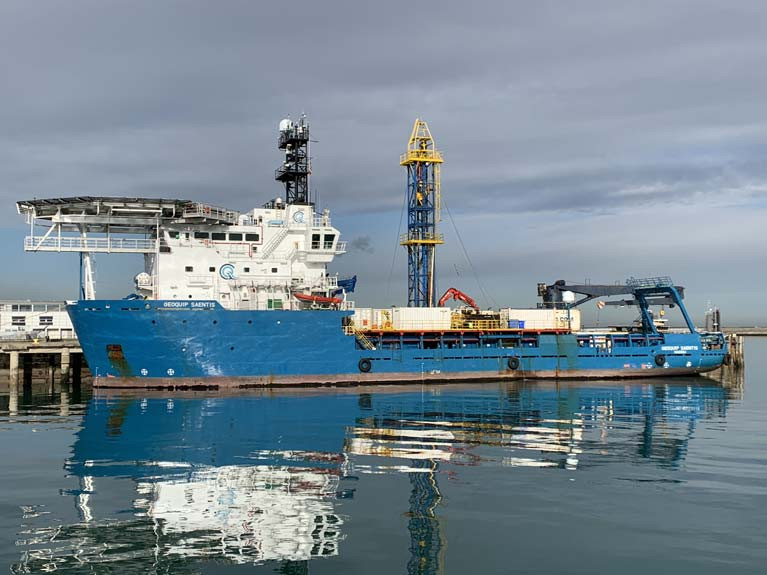
Geotechnical surveys will take place in Outer Dundalk Bay from 6 March 2020, according to the Department of Transport, Tourism and Sport in Marine Notice No. 13 of 2020.
The survey will be completed using the “Geoquip Saentis” (Callsign: C6UM8) currently berthed in Dun Laoghaire Harbour.
The work is necessary to provide geotechnical data to facilitate the development of the Oriel Windfarm.
The survey is expected to start on 6 March 2020 and is expected to be completed by 27 March 2020 but dates provided are weather dependant and therefore subject to change.
When the survey vessel is engaged in survey operations, it will be restricted in its ability to manoeuvre. Other vessels are requested to leave a wide berth. The vessel will be operating 24 hours a day, 7 days a week during the survey works.
Download the full notice below.


 will be going head-to-head with long-lost multi-club-representing sister Two Farr at Howth’s three-day Wave Regatta, starting Friday")


 with his best mate, getting into battle mood in the North African desert during World War II of 1939-45. Anyone who gets along well with a Jack Russell terrier, while looking so very like superstar actor Liam Neeson before Neeson was born, must have had some redeeming features - even if he was a danger to all when partying in a new kitchen")

