


Displaying items by tag: South Coast
Marine Notice: Multibeam & Side-Scan Sonar Survey Off South Coast
The Department of Transport advises that an analogue survey consisting of multibeam, side-scan sonar and magnetometer will be carried out off the South Coast of Ireland by the Marine Institute on behalf of Providence Resources from Saturday 23 to Sunday 31 October, weather permitting.
In addition to the analogue survey, seabed samples and camera imagery will be acquired at approximately 10 stations in the survey area.
The survey will be conducted in Block 48/24 Barryroe, in the North Celtic Basin, around 45–50km from the south coast of Ireland, and will be undertaken by the RV Celtic Voyager (callsign EIQN). The vessel will be towing a side-scan sonar and magnetometer from time to time with cables of up to 300m long.
As this vessel will be restricted in its ability to manoeuvre when surveying, other vessels are requested to keep a wide berth. The vessel will display appropriate lights and signals.
For details of coordinates of the survey area, see Marine Notice No 55 of 2021 which is available to download below.
Marine Notice: Hydrographic Survey Off South Coast

#MarineNotice - The latest Marine Notice from the Department of Transport, Tourism and Sport (DTTAS) advises that a hydrographic and geophysical survey operation will be undertaken by INFOMAR off the south coast of Ireland between 10 July and 7 August 2013.
The RV Celtic Voyager (Call sign EIQN) is expected to carry out the survey operations within an area bounded by co-ordinates detailed in Marine Notice No 26 of 2013, which is available to read or download HERE.
The vessel will be towing a magnetometer sensor with a single cable of up to 100m in length. The RV Celtic Voyager will display appropriate lights and markers and will be listening on VHF Channel 16 throughout the project.
All mariners are reminded of their responsibilities under the International Collision Regulations and are reminded of Marine Notice No 17 of 2007, which gives general advice in relation to the activities of vessels engaged in survey work for hydrographic, seismic, fishing research and underwater operations.
#MarineNotice - The Department of Transport, Tourism and Sport (DTTAS) has issued a Marine Notice advising that a hydrographic and geophysical survey operation is taking place off the south coast till 4 June.
The RV Celtic Voyager (Call sign EIQN) - which performed a similar task off the Clare coast last month - is carrying out the survey operations in an area along the Cork coast marked out in Marine Notice No 18 of 2013, a PDF of which is available to read or download HERE.
The vessel will be towing a magnetometer sensor with a single cable of up to 100m in length. As usual, the vessel will display appropriate lights and markers, and will be listening on VHP Channel 16 throughout the project.
Oil Strike Success Off Cork Coast Could Be Worth Billions

#COASTAL NOTES - Providence Resources has struck big off the south coast of Cork with an oil flow that could be worth billions of euro to the beleaguered Irish economy.
According to the Guardian, the Dublin-based company announced yesterday that oil had started to flow successfully from its Barryroe structure in the north Celtic Sea at nearly twice the rate previously projected.
Providence Resources CEO Tony O'Reilly Jr said the discovery was a "seminal day for Ireland, especially in the runup to St Patrick's Day."
Last month the firm had confirmed the presence of light oil with its first appraisal well at the site, a situation described by its technical director as "extremely encouraging".
Now that a steady flow has been achieved, future extraction from the oil field - comparable to a medium-to-large North Sea field - can surely proceed, which now puts pressure on the Government to grand permission for further exploration around the Irish coast.
As previously reported on Afloat.ie, plans by Providence Rescources to prospect for oil on the east coast off Dalkey Island have been met with fierce opposition by mainland residents and environmental groups.
The Guardian has much more on the story HERE.
South Coast Oil Appraisal 'Extremely Encouraging'
#COASTAL NOTES - Providence Resources has found light out with its first appraisal well off the south coast of Ireland, Offshore reports.
The company's semi-submersible GSF Arctic III drilled a well in 100m water to a depth of more than 2km on its Barryroe structure in the north Celtic Sea.
Indications of hydrocarbons were noted during the drilling, and further tests have confirmed the presence of 12.5m of 'net pay' (the thickness of rock that can deliver oil at a profitable rate) with as much as 87% hydrocarbon saturation.
The next stage will be a well flow test programme to determine whether future oil extraction can proceed.
“The confirmation of high quality light oil within a porous and potentially laterally extensive sandstone system is extremely encouraging," said technical director John O'Sullivan.
As previously reported on Afloat.ie, plans by Providence Rescources to prospect for oil pn the east coast off Dalkey Island have been met with fierce opposition by mainland residents and environmental groups.
Offshore has more on the story HERE.
South Coast Hosts First Irish Bass Festival
#ANGLING - Ireland's south coast will play host to the first Irish Bass Festival this July.
Created and organised by Absolute Fishing, the lure angling event is open to all shore anglers at various venues between Tramore and Dungarvan in Co Waterford, which provide some of the best bass fishing in Europe.
The Irish Bass Festival will operate on catch-and-release rules, with anglers having to photograph their fish, using their own measuring board combined with a unique ID card provided by the organisers.
Competing anglers are also free to roam and fish anywhere along the coastline from Wexford to Cork - provided they're back in time to register their fish!
Details on requirements, reception and fishing times are available on the Irish Bass Festival website HERE.
Fastnet Line Closes For Good
#FERRY NEWS - The Fastnet Line ferry service between Cork and Swansea is to close with the loss of 78 jobs.
As previously reported on Afloat.ie, the operator had been in examinership since last November, and a restructured business plan had been submitted with a view to resuming high-season service in April.
However, in a statement the owners of the Fastnet Line said they had been unable to raise the €1m-plus investment required and that the examinership had "failed".
All 78 jobs will be lost as the company is set to be placed in receivership or liquidation later today.
The Fastnet Line - which was worth around €30 million to Cork in tourist spending - made its maiden voyage from Swansea to Cork in 2010, and was the only direct passenger and freight link between Wales and the south coast of Ireland.
The Irish Times has more on the story HERE.
Coastwatch Warns Over Draining of Cork Wetlands
Ballyvergan marsh is under threat after the discovery of an illegal pipe being used to drain the wetlands area, claims Coastwatch.
The Irish Times reports that the environmental group has called for immediate action over the draining of the marsh near Youghal in Co Cork.
Cork County Council has also confirmed to the paper that a letter regarding an "allegation of unathorised development" has been sent to the landowner.
The marsh at Ballyvergan is one of the largest on the south coast, and is zoned as a special amenity. It is also an important breeding site for migratory birds.
Karin Dubsky of Coastwatch said that the situation highlights the deficiencies in State policy regarding Ireland's wetlands.
The Irish Times has more on the story HERE.
Record Dolphin Strandings 'Inexplicable'
There is growing concern over the rising number of dolphin deaths along Ireland's south coast, the Irish Examiner reports.
The Irish Whale and Dolphin Group (IWDG) announced that a record 19 common dolphins washed up dead in Cork, Waterford and Wexford in January and February of this year alone - 17 more than in the same two months of last year.
Padraig Whooley of the IWDG said the deaths were "inexplicable", noting that there were no obvious signs of injury.
He added that the IWDG did not have the resources or funding to carry out the necessary post-mortems to determine the cause of death, which could be viral in nature.
The Irish Examiner has more on the story HERE.
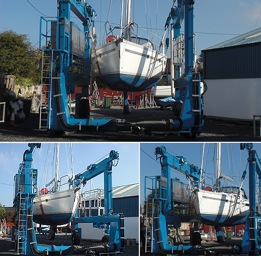
Castlepoint Boatyard
Castlepoint Boatyard is based in Crosshaven, Co. Cork, it offers the following services...
25 Tonne Travel Hoist
• Wood and GRP Repairs
• Respray, Coppercoat and
• Osmosis Treatments
• Bow Thruster and Heating
• Agents for Mermaid Diesel Engines
• Winter Storage
• Maintenance and insurance work
New 25 Tonne Travel Hoist
Crosshaven,
Co. Cork
Tel: 021 4832154
Email: [email protected]


 as lead helm, rounds the Fastnet Rock on the way to the overall win in 1987")


 Michael Murphy Schull Harbour Sailing Club (SHSC), Eric Coogan Heineken Ireland, Mark Murphy, Commodore SHSC, Jack Allen SHSC, Carmel O'Regan SHSC, Cornelious Ndlovu, Schull Harbour Hotel Operations Manager and Derval Murphy SHSC")
