A team of scientists who have been self-isolating like astronauts for the past fortnight set sail from Galway at the weekend on an unusual mission.
Six researchers from the Dublin Institute for Advanced Studies (DIAS) and 15 crew on Marine Institute’s Celtic Explorer will retrieve a network of ocean bottom sensors which were deployed across the entire Irish offshore area 18 months ago.
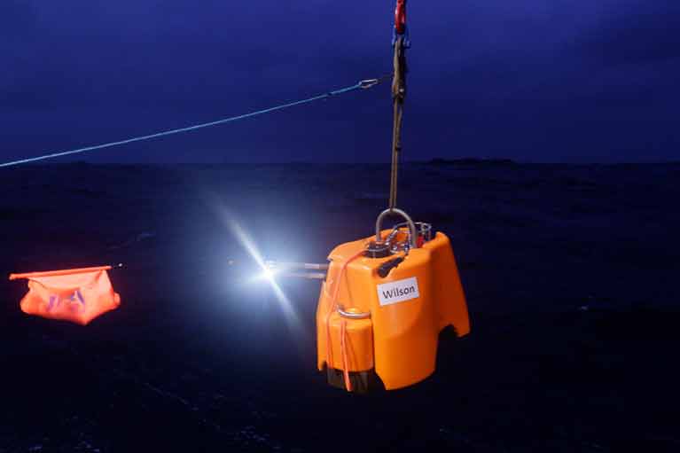
Ireland’s earthquake activity and data on more distant seismic events, along with the movements of migratory whales, were measured by the 18 seismometers, which must now be retrieved from the ocean.
Strict social distancing measures will be applied on the ship, with staggered meal times and no access to the gym or sauna for the first two weeks of the three-week voyage.
The scientists travelled by private bus directly from their individual homes, and will all have separate cabins as part of the protocol to protect against the Covid-19 virus.
 A sensor being deployed in 2018 - The technology aims to record Irish offshore earthquakes
As Afloat reported at the time, the sensors were deployed from the Marine Institute ship in September 2018 by a team led by Dr Sergei Lebedev, a seismologist with the DIAS.
DIAS school of cosmic physics director Prof Chris Bean says the deployment was “by far the most comprehensive in both Europe and the north-east Atlantic”.
“There are specific seismically-active zones where clusters of these types of instruments have been placed before, but this is a first for Ireland,” Prof Bean said.
The sensors aimed to record Irish offshore earthquakes, and research how the earth’s oceans are pressurising the sea floor in really deep water, with big storms possibly triggering submarine landslides and tsunamis.
“The seismometers also have a pressure sensor which can record sound waves in the water – as in whales, dolphins or industrial sounds,” Prof Bean explained.
The deployment was part of the SEA-SEIS project, which aimed to measure movements on the floor of the Atlantic Ocean and register acoustic waves in the water.
“Ninety per cent of Ireland’s territory is offshore, most of it to the west of Ireland. Hidden beneath the waves, there are spectacular mountains, deep valleys, and many extinct volcanoes, similar to those that formed the Giant’s Causeway,”Dr Lebedev said.
The network of seismometers were deployed across an area spanning over 1,500 kilometres from north to south and over 1,000 kilometres from east to west, with some sensors in British and Icelandic and in Ireland’s offshore territory.
“Our mission with this expedition is to retrieve these hugely valuable seismometers, so we can begin the exciting process of analysing the data they have gathered,” Dr Lebedev said.
“This data will shed light on the nature and history of the ocean floor along Ireland’s coast and on the life and movements of the great baleen whales of the North Atlantic,” Dr Lebedev said.
DIAS and the Geological Survey Ireland run the State’s terrestrial network of seismometers to study ground vibrations, ranging from small movements caused by local activities like quarry blasts to large global earthquakes picked up on the Irish network.
The offshore array is a temporary arrangement, Dr Lebedev said.
“This is the first time ever such a large array was deployed, so the data is quite unique and of huge value and that’s why we have to go now.”


