Menu

Ireland's sailing, boating & maritime magazine

Marine Institute Banner Advert 2023

75 per cent of Ireland's Land Territory Will Be Mapped this Year, GSI Says

7th September 2020
The survey aircraft is a white, twin-propeller plane (as pictured), which is easily identified by its red tail and black stripe as well as the word ‘SURVEY’ The survey aircraft is a white, twin-propeller plane (as pictured), which is easily identified by its red tail and black stripe as well as the word ‘SURVEY’

Ireland should have 75 per cent of its land territory mapped this year, according to the Geological Survey of Ireland (GSI).

A low-flying aircraft will gather geophysical date over counties Laois, Tipperary, Kilkenny and Waterford, and neighbouring parts of Offaly, Cork, Carlow and Kildare from September until the end of the year, weather permitting, the GSI says.

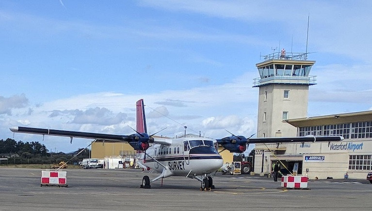
Based at Waterford airport, the survey plane will be flying at 60 metres over rural areas – about eight times the height of a two-storey house – and 240 metres over urban areas in the coming months, as approved by the Irish Aviation Authority.

The GSI is already involved in seabed mapping with the Marine Institute under the INFOMAR programme, and the Tellus Survey has been conducted on land over the last nine years.

Tellus collects geochemical and geophysical data on rocks, soil and water across Ireland. It involves airborne physical surveying using a low-flying aircraft, and ground-based geochemical surveying of soil, stream water and stream sediment.

It is currently funded under Project2040 - the National Development Plan – by the Department of Communications, Climate Action and Environment.

The department says it has “the potential to deliver positive economic, environmental and agricultural benefits by helping to assist in local environment understanding, soil management, and natural resource potential for these counties”.

Tellus project manager and senior geologist Dr James Hodgson describes it as “an important national project, providing valuable insights into the geological makeup of Ireland”.

“The data collected from the Tellus Survey helps us to sustainably manage our environment and natural resources as well as protecting public health,” he said.

The survey aircraft is a white, twin-propeller plane (as pictured), which is easily identified by its red tail and black stripe as well as the word ‘SURVEY’ and registration number C-GSGF written across both sides of the plane.

Data collected throughout the Tellus project is published and made freely available to all on the Tellus website (www.tellus.ie).

Published in Marine Science
Lorna Siggins

About The Author

Lorna Siggins

Email The Author

Lorna Siggins is a print and radio reporter, and a former Irish Times western correspondent. She is the author of Search and Rescue: True stories of Irish Air-Sea Rescues and the Loss of R116 (2022); Everest Callling (1994) on the first Irish Everest expedition; Mayday! Mayday! (2004); and Once Upon a Time in the West: the Corrib gas controversy (2010). She is also co-producer with Sarah Blake of the Doc on One "Miracle in Galway Bay" which recently won a Celtic Media Award

We've got a favour to ask

More people are reading Afloat.ie than ever thanks to the power of the internet but we're in stormy seas because advertising revenues across the media are falling fast. Unlike many news sites, we haven’t put up a paywall because we want to keep our marine journalism open.

Afloat.ie is Ireland's only full–time marine journalism team and it takes time, money and hard work to produce our content.

So you can see why we need to ask for your help.

If everyone chipped in, we can enhance our coverage and our future would be more secure. You can help us through a small donation. Thank you.

Direct Donation to Afloat button

Marine Science Perhaps it is the work of the Irish research vessel RV Celtic Explorer out in the Atlantic Ocean that best highlights the essential nature of marine research, development and sustainable management, through which Ireland is developing a strong and well-deserved reputation as an emerging centre of excellence. From Wavebob Ocean energy technology to aquaculture to weather buoys and oil exploration these pages document the work of Irish marine science and how Irish scientists have secured prominent roles in many European and international marine science bodies.


At A Glance – Ocean Facts

  • 71% of the earth’s surface is covered by the ocean
  • The ocean is responsible for the water cycle, which affects our weather
  • The ocean absorbs 30% of the carbon dioxide added to the atmosphere by human activity
  • The real map of Ireland has a seabed territory ten times the size of its land area
  • The ocean is the support system of our planet.
  • Over half of the oxygen we breathe was produced in the ocean
  • The global market for seaweed is valued at approximately €5.4 billion
  • · Coral reefs are among the oldest ecosystems in the world — at 230 million years
  • 1.9 million people live within 5km of the coast in Ireland
  • Ocean waters hold nearly 20 million tons of gold. If we could mine all of the gold from the ocean, we would have enough to give every person on earth 9lbs of the precious metal!
  • Aquaculture is the fastest growing food sector in the world – Ireland is ranked 7th largest aquaculture producer in the EU
  • The Atlantic Ocean is the second largest ocean in the world, covering 20% of the earth’s surface. Out of all the oceans, the Atlantic Ocean is the saltiest
  • The Pacific Ocean is the largest ocean in the world. It’s bigger than all the continents put together
  • Ireland is surrounded by some of the most productive fishing grounds in Europe, with Irish commercial fish landings worth around €200 million annually
  • 97% of the earth’s water is in the ocean
  • The ocean provides the greatest amount of the world’s protein consumed by humans
  • Plastic affects 700 species in the oceans from plankton to whales.
  • Only 10% of the oceans have been explored.
  • 8 million tonnes of plastic enter the ocean each year, equal to dumping a garbage truck of plastic into the ocean every minute.
  • 12 humans have walked on the moon but only 3 humans have been to the deepest part of the ocean.

(Ref: Marine Institute)

Featured Sailing School

INSS sidebutton

Featured Clubs

dbsc mainbutton
Howth Yacht Club
Kinsale Yacht Club
National Yacht Club
Royal Cork Yacht Club
Royal Irish Yacht club
Royal Saint George Yacht Club

Featured Brokers

leinster sidebutton

Featured Webcams

Featured Associations

ISA sidebutton
ICRA
isora sidebutton

Featured Marinas

dlmarina sidebutton

Featured Sailmakers

northsails sidebutton
uksails sidebutton
quantum sidebutton
watson sidebutton

Featured Chandleries

CHMarine Afloat logo
https://afloat.ie/resources/marine-industry-news/viking-marine

Featured Blogs

W M Nixon - Sailing on Saturday
podcast sidebutton
BSB sidebutton
wavelengths sidebutton
 

Please show your support for Afloat by donating