Displaying items by tag: Irish Weather Buoy Network
‘Bob The Buoy’ Retires Ashore To Valentia Island
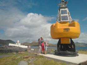
#Buoys - After more than two decades of service as part of the Marine Institute’s national weather buoy network, the affectionately named ‘Bob the Buoy’ will see out his retirement as a permanent resident at Valentia Lighthouse.
Bob withstood countless storms over the years, reporting hourly weather observations to Met Éireann and European partners.
Now visitors to Valentia Island in Co Kerry can check out Bob’s new home at Cromwell Point and get a closer insight into Ireland’s marine navigation and safeguarding history.
“Weather buoys are a fundamental aspect of our maritime history, and it is our hope that Bob will emphasise this in his new location here, on Valentia, the most extreme south-westerly point of Europe,” said Paul Duff, member of the lighthouse committee which worked closely with the Marine Institute on the buoy’s relocation.
“It is fitting that he should be placed here, and we look forward to incorporating him into our visitor experience,” Duff added.
Lighthouse committee chair Brian Morgan said: “This is such a fantastic artefact. It is our hope that we can reinstate Bob, a working retirement if you like, in order for us to provide a weather feed which we can share through our community, and lighthouse network, utilising the available technology, but we will let him settle in first.”
Dr Guy Westbrook from the Marine Institute said he and his colleagues are delighted that Bob has a new home at Valentia to educate the public about the weather buoy network.
“Designed to improve weather forecasts and safety at sea around Ireland, the buoy network provides vital data for weather forecasts, shipping bulletins, gale and swell warnings as well as data for general public information and research,” Dr Westbrook added.
In other news, the large marker buoy found adrift by Clifden RNLI in late July has been removed from the Connemara coast.
Harry Duggan of the Commissioners of Irish Lights says the buoy, which originated in Canadian waters, was as of yesterday (Friday 10 August) on its way to CIL headquarters in Dun Laoghaire.
The CIL recommends caution around any and all aids to navigation around the Irish coast.
Irish Weather Buoy Network Features On RTE’s ‘Weather Live’ Tonight
#Weather - The work of the Marine Institute's Irish Weather Buoy Network will feature on RTE One's Weather Live this evening (Friday 17 November).
The TV programme has filmed the redeployment of the M5 weather buoy, which broke free during Storm Ophelia. The show will also feature an interview with the Marine Institute's Dr Guy Westbrook.
A weather buoy has been transported to the Botanic Gardens in Dublin, where Weather Live broadcasts live, so those tuning in can see what one looks like.
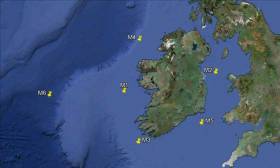
The Irish Weather Buoy Network delivers data every hour that is then fed into a global information network which includes Met Éireann, the Irish Meterological Service. This data is then used to inform forecasts as well as long-term information gathering.
Located off the South East coast, the M5 weather buoy captured two records during Ophelia: a record individual wave (Hmax) of 17.81m and a record significant wave height (Hs) of 12.97m.
During the storm, the raging seas caused the M5 mooring to break and the buoy needed to be recovered to shore when the seas had calmed.
Due to the relative importance to forecasters of the M5 weather observing location, it was decided to deploy the M4 target system that had been on test in Killybegs at M5.
This buoy was disassembled and transported by road to Cobh dockyard where it was loaded onto the ILV Granuaile and prepared for subsequent deployment.
Marine Institute staff embarked the vessel on 1 November and deployment of the buoy took place the next day in exceptionally calm conditions.
Weather Live is a three-day television event on RTÉ One that focuses on the fascinating world of weather. It’s presented by Kathryn Thomas and features meteorologists including Evelyn Cusack, Gerald Fleming and Gerry Murphy, and coincides with events for Science Week 2017, as previously reported on Afloat.ie.
The third and final broadcast of the series goes out live this evening Friday 17 November at 7pm on RTE One.
Sixty–Foot Record Wave Recorded During Hurricane Ophelia
Record wave heights were captured by the Irish Weather Buoy Network during Hurricane Ophelia on Monday 16th October, causing one of the five weather buoys to break it moorings.
The highest wave was recorded off the Irish coastline at 16.00 on Monday when the M5 weather buoy off the South East coast, measured a record individual wave (Hmax) of 17.81m* and a record significant wave height (Hs) of 12.97m **.
The M5 weather buoy subsequently broke away from its mooring and the Marine Institute coordinated the retrieval process as a matter of urgency. The M5 was recovered yesterday by the MV Puffin of Fastnet Shipping (Waterford) and brought ashore last night.
As Ophelia moved northwards, the M2 buoy to the east of Dublin also experienced a record significant wave height (HS )** of 6.64m measured at 18.00 on Monday 16th.
![]() Waves lash the Baltimore beacon in West Cork during Storm Ophelia. Photo: Youen Jacob
Waves lash the Baltimore beacon in West Cork during Storm Ophelia. Photo: Youen Jacob
Earlier in the day, at 12.00, the M3 buoy, off the South West coast measured an individual wave height of 13.59m, although this was not a record wave for this buoy.
In addition to measuring the waves, the weather buoy network, which is managed by the Marine Institute provides further vital atmospheric (including wind speed) and oceanographic information to support both maritime safety and, importantly in storm events such as Ophelia, help to validate the weather forecast models run by Met Éireann providing guidance to the national emergency planning efforts.
The Irish Weather Buoy Network is designed to improve weather forecasts and safety at sea around Ireland. The buoy network also provides operational ocean models, shipping bulletins, gale and swell warnings as well as data for general public information and research. The network is managed by the Marine Institute in collaboration with Met Éireann, the UK Met Office and the Irish Department of Transport, Tourism and Sport (DTTAS). Real time data from the network can be found here.


