Menu

Ireland's sailing, boating & maritime magazine

Dublin Bay Boating News and Information

Diving Bell Opens as Newest Dublin Visitor Attraction

15th July 2015
Diving Bell Opens as Newest Dublin Visitor Attraction

#divingbell – The Minister for Transport, Tourism and Sport, Paschal Donohoe, TD, has officially opened Dublin's newest visitor attraction, Dublin Port's Diving Bell. As reported by Afloat.ie back in February, following a four month restoration project by Dublin Port Company, the striking, orange metal structure on Sir John Rogerson's Quay is an important addition to the public realm in Docklands. It will appeal to local people who have always wondered about the purpose of this odd-looking bell structure, and visitors to the city keen to learn more about Dublin as a port city.

Transformed into an interpretive exhibition, visitors can now learn in detail about the origin and history of this important artefact in Dublin's maritime history. An ingenious feat of Irish engineering, the Diving Bell was essential in building Dublin's quay walls for 87 years.

unnamed-1.jpg

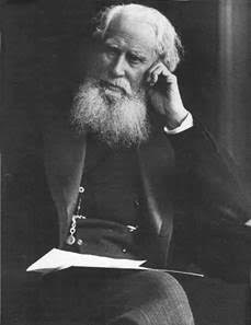
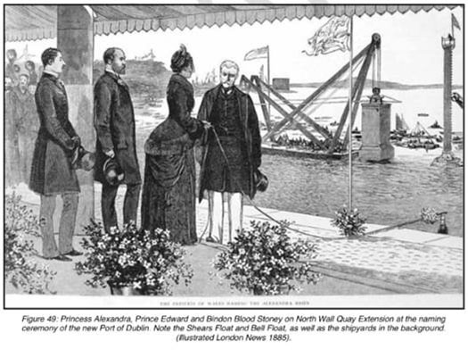
The Diving Bell was designed by the port engineer Bindon Blood Stoney (1828 to 1907) above and built by Grendon and Co., Drogheda. It was delivered to the Port in 1866, entered service in 1871 and was used in the building of the Port's quay walls until 1958. Stoney was a prodigious engineer and among his achievements were the building of the Boyne Viaduct in Drogheda, the construction of O'Connell Bridge and the building of many of the Port's quay walls including Sir John Rogerson's Quay and North Wall Quay Extension.

The Diving Bell was used in the building of the Port's quay walls from the Victorian era right up until almost the 1960's. It was a ground-breaking piece of engineering innovation in its day. Its lower section was hollow and bottomless, providing just enough room for six men to work at a time. Once lowered into position on the riverbed, the crew entered through an access funnel from the surface and compressed air was fed in from an adjacent barge. The men inside the bell worked on the river bed exposed at their feet, excavating the site where a massive concrete block would later go; all the excavated soil was stashed in trays hanging inside the bell, and brought up when the bell was lifted.

Carried out by Weslin Construction Ltd., the restoration project involved elevating the 13m tall, 90 tonne Diving Bell onto a two metre steel structure to create a ramped public access route underneath. A water feature now runs beneath the structure accompanied by a series of interpretative panels explaining the historical, social and engineering significance of the Diving Bell. The exhibition is also illuminated at night time using energy efficient LED lighting.

image003.jpg

The project was designed with the expertise of a range of people including the architect Sean O'Laoire, the sculptor Vivienne Roche, Tom Cosgrave (professor of engineering at the University of Limerick) and the late Mary Mulvihill of Ingenious Ireland.

Eamonn O'Reilly, Chief Executive, Dublin Port Company said: "Dublin Port Company is proud to bring the Diving Bell to life for Dubliners and visitors to the city. Our restoration project pays tribute to Bindon Blood Stoney who built the deepwater quays in Dublin in the Victorian era. It also commemorates the generations of port employees who worked in the bell. It invites the city's visitors and inhabitants, new and old, to better understand Dublin as a port city with a wealth of industrial heritage to uncover. I would encourage people to visit and discover for themselves the significance of this magnificent structure. The Diving Bell is the first of a series of important industrial heritage exhibits we plan to create in the years ahead."

The Minister for Transport, Tourism and Sport, Paschal Donohoe, T.D., said: "It is fantastic to see the Diving Bell restored to its former glory for a new generation of Dubliners and visitors to discover. The Diving Bell is a wonderful addition to Dublin's array of historical attractions and I am sure it will become a new favourite on the tourist trail through the docklands area. I commend Dublin Port Company and all involved in the project to preserve and restore this fascinating artefact for the city."

Published in Dublin Bay
Afloat.ie Team

About The Author

Afloat.ie Team

Email The Author

Afloat.ie is Ireland's dedicated marine journalism team.

Have you got a story for our reporters? Email us here.

We've got a favour to ask

More people are reading Afloat.ie than ever thanks to the power of the internet but we're in stormy seas because advertising revenues across the media are falling fast. Unlike many news sites, we haven’t put up a paywall because we want to keep our marine journalism open.

Afloat.ie is Ireland's only full–time marine journalism team and it takes time, money and hard work to produce our content.

So you can see why we need to ask for your help.

If everyone chipped in, we can enhance our coverage and our future would be more secure. You can help us through a small donation. Thank you.

Direct Donation to Afloat button

Dublin Bay

Dublin Bay on the east coast of Ireland stretches over seven kilometres, from Howth Head on its northern tip to Dalkey Island in the south. It's a place most Dubliners simply take for granted, and one of the capital's least visited places. But there's more going on out there than you'd imagine.

The biggest boating centre is at Dun Laoghaire Harbour on the Bay's south shore that is home to over 1,500 pleasure craft, four waterfront yacht clubs and Ireland's largest marina.

The bay is rather shallow with many sandbanks and rocky outcrops, and was notorious in the past for shipwrecks, especially when the wind was from the east. Until modern times, many ships and their passengers were lost along the treacherous coastline from Howth to Dun Laoghaire, less than a kilometre from shore.

The Bay is a C-shaped inlet of the Irish Sea and is about 10 kilometres wide along its north-south base, and 7 km in length to its apex at the centre of the city of Dublin; stretching from Howth Head in the north to Dalkey Point in the south. North Bull Island is situated in the northwest part of the bay, where one of two major inshore sandbanks lie, and features a 5 km long sandy beach, Dollymount Strand, fronting an internationally recognised wildfowl reserve. Many of the rivers of Dublin reach the Irish Sea at Dublin Bay: the River Liffey, with the River Dodder flow received less than 1 km inland, River Tolka, and various smaller rivers and streams.

Dublin Bay FAQs

There are approximately ten beaches and bathing spots around Dublin Bay: Dollymount Strand; Forty Foot Bathing Place; Half Moon bathing spot; Merrion Strand; Bull Wall; Sandycove Beach; Sandymount Strand; Seapoint; Shelley Banks; Sutton, Burrow Beach

There are slipways on the north side of Dublin Bay at Clontarf, Sutton and on the southside at Dun Laoghaire Harbour, and in Dalkey at Coliemore and Bulloch Harbours.

Dublin Bay is administered by a number of Government Departments, three local authorities and several statutory agencies. Dublin Port Company is in charge of navigation on the Bay.

Dublin Bay is approximately 70 sq kilometres or 7,000 hectares. The Bay is about 10 kilometres wide along its north-south base, and seven km in length east-west to its peak at the centre of the city of Dublin; stretching from Howth Head in the north to Dalkey Point in the south.

Dun Laoghaire Harbour on the southside of the Bay has an East and West Pier, each one kilometre long; this is one of the largest human-made harbours in the world. There also piers or walls at the entrance to the River Liffey at Dublin city known as the Great North and South Walls. Other harbours on the Bay include Bulloch Harbour and Coliemore Harbours both at Dalkey.

There are two marinas on Dublin Bay. Ireland's largest marina with over 800 berths is on the southern shore at Dun Laoghaire Harbour. The other is at Poolbeg Yacht and Boat Club on the River Liffey close to Dublin City.

Car and passenger Ferries operate from Dublin Port to the UK, Isle of Man and France. A passenger ferry operates from Dun Laoghaire Harbour to Howth as well as providing tourist voyages around the bay.

Dublin Bay has two Islands. Bull Island at Clontarf and Dalkey Island on the southern shore of the Bay.

The River Liffey flows through Dublin city and into the Bay. Its tributaries include the River Dodder, the River Poddle and the River Camac.

Dollymount, Burrow and Seapoint beaches

Approximately 1,500 boats from small dinghies to motorboats to ocean-going yachts. The vast majority, over 1,000, are moored at Dun Laoghaire Harbour which is Ireland's boating capital.

In 1981, UNESCO recognised the importance of Dublin Bay by designating North Bull Island as a Biosphere because of its rare and internationally important habitats and species of wildlife. To support sustainable development, UNESCO’s concept of a Biosphere has evolved to include not just areas of ecological value but also the areas around them and the communities that live and work within these areas. There have since been additional international and national designations, covering much of Dublin Bay, to ensure the protection of its water quality and biodiversity. To fulfil these broader management aims for the ecosystem, the Biosphere was expanded in 2015. The Biosphere now covers Dublin Bay, reflecting its significant environmental, economic, cultural and tourism importance, and extends to over 300km² to include the bay, the shore and nearby residential areas.

On the Southside at Dun Laoghaire, there is the National Yacht Club, Royal St. George Yacht Club, Royal Irish Yacht Club and Dun Laoghaire Motor Yacht Club as well as Dublin Bay Sailing Club. In the city centre, there is Poolbeg Yacht and Boat Club. On the Northside of Dublin, there is Clontarf Yacht and Boat Club and Sutton Dinghy Club. While not on Dublin Bay, Howth Yacht Club is the major north Dublin Sailing centre.

© Afloat 2020