Menu

Ireland's sailing, boating & maritime magazine

Dublin Bay Boating News and Information

Repaired Containership Finally Departs Dun Laoghaire Harbour on New Year's Day Bank Holiday

4th January 2022
The 5,210tdw feeder containership Anna G which was towed to Dun Laoghaire Harbour to facilitate engine repairs, has after seven weeks finally departed the south Dublin Bay port. The 101m vessel had eased off the Carlisle Pier by going astern and using a bow thruster (as above see wash on waterline) was also applied to swing further around to face the harbour mouth. The ship is bound for Felixstowe, the UK's largest container port. The 5,210tdw feeder containership Anna G which was towed to Dun Laoghaire Harbour to facilitate engine repairs, has after seven weeks finally departed the south Dublin Bay port. The 101m vessel had eased off the Carlisle Pier by going astern and using a bow thruster (as above see wash on waterline) was also applied to swing further around to face the harbour mouth. The ship is bound for Felixstowe, the UK's largest container port. Credit: Jehan Ashmore

A containership which was under tow from Carlingford Lough to Dun Laoghaire Harbour in mid-November finally departed yesterday following engine repairs that lasted much longer then expected, writes Jehan Ashmore.

Anna G with a capacity for 515TEU containers departed on the Monday Bank Holiday following New Year's Day that fell on Saturday. As such the long weekend was busy as when the ship eased off the Carlisle Pier the departure was observed by many walkers thronging the harbour's East Pier.

Originally, Anna G was to remain in the port to effect engine repairs for an estimated four weeks according to Dun Laoghaire-Rathdown County Council as previously reported, however the vessel operated by German shipowner Reederei-Gerdes would stay in port beyond this timeframe.

It was last month when various engine parts had to be shipped to Germany to be machined and though they were returned to the ship, work that was to be concluded before Christmas did not arise.

This forced Anna G to remain in the harbour and into the New Year, coupled with technicians away on leave for the festive period. This further delayed the works until their return last week to complete repairs.

Previously on Sunday, Anna G departed (albeit within the harbour) from St. Michael's Pier to vacate berth No. 4. This was to due operational reasons, though on that same day saw the arrival to the same berth of Irish Lights aids to navigation tender ILV Granuaile from Belfast Harbour. 

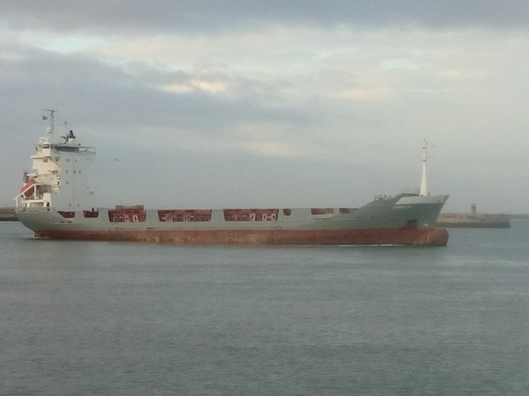
As for the 5,210tdw containership which shifted to the adjacent Carlisle Pier at berth No. 2 which is on the far side of the pier opposite of the East Pier.

On the next day a Dublin Port pilot cutter DPC Tolka arrived mid-afternoon to embark a pilot on board the Limassol registered Anna G.

This led to the ship cautiously easing off the Carlisle Pier while using a bow thruster and also going astern before swinging the bow off the East Pier's bandstand from where bystanders saw the 101m ship get underway. 

Having swung around sufficiently, Anna G was facing the harbour mouth and with that a single blast of the ship's horn also marked the long awaited departure of the ship which had been in port for more than seven weeks.

Anna G then set off into Dublin Bay and soon afterwards the DPC Tolka returned to disembark the pilot while off Scotsman's Bay. With that procedure concluded the ship continued on a southerly course with the passing off The Muglins beacon off Dalkey.

The containership's next port of call is the Port of Felixstowe, Britain's biggest 'box'-boat port.

As of 12 noon today, Anna G had already passed Land's End, Cornwall and was approaching the eastbound shipping lane of the English Channel.

Tomorrow night the vessel is due to arrive at the North Sea port. 

Published in Dublin Bay
Jehan Ashmore

About The Author

Jehan Ashmore

Email The Author

Jehan Ashmore is a marine correspondent, researcher and photographer, specialising in Irish ports, shipping and the ferry sector serving the UK and directly to mainland Europe. Jehan also occasionally writes a column, 'Maritime' Dalkey for the (Dalkey Community Council Newsletter) in addition to contributing to UK marine periodicals. 

We've got a favour to ask

More people are reading Afloat.ie than ever thanks to the power of the internet but we're in stormy seas because advertising revenues across the media are falling fast. Unlike many news sites, we haven’t put up a paywall because we want to keep our marine journalism open.

Afloat.ie is Ireland's only full–time marine journalism team and it takes time, money and hard work to produce our content.

So you can see why we need to ask for your help.

If everyone chipped in, we can enhance our coverage and our future would be more secure. You can help us through a small donation. Thank you.

Direct Donation to Afloat button

Dublin Bay

Dublin Bay on the east coast of Ireland stretches over seven kilometres, from Howth Head on its northern tip to Dalkey Island in the south. It's a place most Dubliners simply take for granted, and one of the capital's least visited places. But there's more going on out there than you'd imagine.

The biggest boating centre is at Dun Laoghaire Harbour on the Bay's south shore that is home to over 1,500 pleasure craft, four waterfront yacht clubs and Ireland's largest marina.

The bay is rather shallow with many sandbanks and rocky outcrops, and was notorious in the past for shipwrecks, especially when the wind was from the east. Until modern times, many ships and their passengers were lost along the treacherous coastline from Howth to Dun Laoghaire, less than a kilometre from shore.

The Bay is a C-shaped inlet of the Irish Sea and is about 10 kilometres wide along its north-south base, and 7 km in length to its apex at the centre of the city of Dublin; stretching from Howth Head in the north to Dalkey Point in the south. North Bull Island is situated in the northwest part of the bay, where one of two major inshore sandbanks lie, and features a 5 km long sandy beach, Dollymount Strand, fronting an internationally recognised wildfowl reserve. Many of the rivers of Dublin reach the Irish Sea at Dublin Bay: the River Liffey, with the River Dodder flow received less than 1 km inland, River Tolka, and various smaller rivers and streams.

Dublin Bay FAQs

There are approximately ten beaches and bathing spots around Dublin Bay: Dollymount Strand; Forty Foot Bathing Place; Half Moon bathing spot; Merrion Strand; Bull Wall; Sandycove Beach; Sandymount Strand; Seapoint; Shelley Banks; Sutton, Burrow Beach

There are slipways on the north side of Dublin Bay at Clontarf, Sutton and on the southside at Dun Laoghaire Harbour, and in Dalkey at Coliemore and Bulloch Harbours.

Dublin Bay is administered by a number of Government Departments, three local authorities and several statutory agencies. Dublin Port Company is in charge of navigation on the Bay.

Dublin Bay is approximately 70 sq kilometres or 7,000 hectares. The Bay is about 10 kilometres wide along its north-south base, and seven km in length east-west to its peak at the centre of the city of Dublin; stretching from Howth Head in the north to Dalkey Point in the south.

Dun Laoghaire Harbour on the southside of the Bay has an East and West Pier, each one kilometre long; this is one of the largest human-made harbours in the world. There also piers or walls at the entrance to the River Liffey at Dublin city known as the Great North and South Walls. Other harbours on the Bay include Bulloch Harbour and Coliemore Harbours both at Dalkey.

There are two marinas on Dublin Bay. Ireland's largest marina with over 800 berths is on the southern shore at Dun Laoghaire Harbour. The other is at Poolbeg Yacht and Boat Club on the River Liffey close to Dublin City.

Car and passenger Ferries operate from Dublin Port to the UK, Isle of Man and France. A passenger ferry operates from Dun Laoghaire Harbour to Howth as well as providing tourist voyages around the bay.

Dublin Bay has two Islands. Bull Island at Clontarf and Dalkey Island on the southern shore of the Bay.

The River Liffey flows through Dublin city and into the Bay. Its tributaries include the River Dodder, the River Poddle and the River Camac.

Dollymount, Burrow and Seapoint beaches

Approximately 1,500 boats from small dinghies to motorboats to ocean-going yachts. The vast majority, over 1,000, are moored at Dun Laoghaire Harbour which is Ireland's boating capital.

In 1981, UNESCO recognised the importance of Dublin Bay by designating North Bull Island as a Biosphere because of its rare and internationally important habitats and species of wildlife. To support sustainable development, UNESCO’s concept of a Biosphere has evolved to include not just areas of ecological value but also the areas around them and the communities that live and work within these areas. There have since been additional international and national designations, covering much of Dublin Bay, to ensure the protection of its water quality and biodiversity. To fulfil these broader management aims for the ecosystem, the Biosphere was expanded in 2015. The Biosphere now covers Dublin Bay, reflecting its significant environmental, economic, cultural and tourism importance, and extends to over 300km² to include the bay, the shore and nearby residential areas.

On the Southside at Dun Laoghaire, there is the National Yacht Club, Royal St. George Yacht Club, Royal Irish Yacht Club and Dun Laoghaire Motor Yacht Club as well as Dublin Bay Sailing Club. In the city centre, there is Poolbeg Yacht and Boat Club. On the Northside of Dublin, there is Clontarf Yacht and Boat Club and Sutton Dinghy Club. While not on Dublin Bay, Howth Yacht Club is the major north Dublin Sailing centre.

© Afloat 2020