Menu

Ireland's sailing, boating & maritime magazine

Dublin Bay Boating News and Information

Displaying items by tag: Alpha Marine

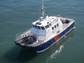
Wicklow Port based multi-disciplinary marine company, Alpha Marine has acquired a Damen Shipyard built multi-cat of their 2309 design, which had been operating in the Netherlands.

The purchase of the multicat from Purus HST of Swansea, Wales, was concluded in mid-December and represents a significant investment by the Irish marine consultancy company which has an existing fleet of five vessels providing tug, workboat charter and marine survey services.

AMS Retriever is the new name given to the multipurpose Dutch shipyard built vessel which will work throughout Europe in support of offshore and near shore energy projects, dredging as well as port infrastructure.

The shallow draft multicat is a powerful and versatile craft suitable for near coastal marine civil support projects. In addition the multicat is an ideal partner for dredge assist, towage, survey, anchor and buoy handling duties.

Equipped with powerful crane and winches, AMS Retriever has a bollard pull of 16.2 tonnes and has a Bureau Veritas (BV) classification giving the vessel plying limits for un-restricted navigation.

A deck load is available for 24 hour operations and a crew of 7 have accommodation in heated and air conditioned cabins.

With the AMS Retriever joining the company, Afloat highlights that a former tug of the same name is no longer part of the fleet.

Published in Ports & Shipping

Alpha Marine will undertake a geophysical survey campaign in relation to the Clogherhead Offshore Wind Farm off the coast of Co Louth from next Thursday 25 May to Wednesday 27 July.

The survey will be conducted by the Baltic Explorer (callsign LYBW) utilising multibeam echo sounders, sub-bottom profilers, side-scan sonars, magnetometers and ultra-high-resolution survey equipment.

Geophysical equipment will be both hull-mounted and towed. Typically, the towed cable lengths will be about four times the water depth while acquiring survey data.

The work will be conducted on a 24-hour basis and the work vessel will display appropriate lights and signals. Mariners are advised to keep continuous watch on VHF Channel 16 when navigating the area.

All other vessels operating within this area are requested to keep their distance and pass at minimum speed to reduce vessel wash.

Mariners are also asked to note that the start date and the duration of the activity are dependent on weather and work progress.

Coordinates of the survey area and contact details can be found in Marine Notice No 26 of 2022, attached below.

Published in Power From the Sea

#ports&shipping  - Wicklow based Alpha Marine are carrying out a dredging project off the UK south coast for an offshore windfarm project, writes Jehan Ashmore.

The vessel support and marine services company deployed the Husky, a twin screw shallow draft tug to conduct nearshore dredging support at the Rampion Offshore Windfarm.

Among the marine engineering plant involved in the project off the Sussex coast has been the ‘Spud’ barge Beluga. The vessel has been manoeuvred by Husky out of Shoreham Harbour which is a base for such operations. 

This has involved the dredging spread for the excavation and backfill of the trench for the export cable leading from the Rampion Offshore Windfarm.

Published in Dredging
Tagged under

#Charter - Alpha Marine, formerly Island Shipping, based in Wicklow, has seen the return of one of its wind-farm support vessels following a survey charter in the North Sea, writes Jehan Ashmore.

The water-jet propelled Island Panther had been working in the Waddenzee, an intertidal zone of the Ems Estuary located between The Netherlands and Germany. Along this coast are the Frisian /Wadden Islands, an archipelago that lies off these countries and stretches as far as Denmark.

Island Panther which also is a crew transfer vessel, was deployed from the Dutch port of Ijmuiden to conduct the survey zone. The 17m craft operated in the ultra-shallow waters of the survey site.


Published in Ports

Dublin Bay

Dublin Bay on the east coast of Ireland stretches over seven kilometres, from Howth Head on its northern tip to Dalkey Island in the south. It's a place most Dubliners simply take for granted, and one of the capital's least visited places. But there's more going on out there than you'd imagine.

The biggest boating centre is at Dun Laoghaire Harbour on the Bay's south shore that is home to over 1,500 pleasure craft, four waterfront yacht clubs and Ireland's largest marina.

The bay is rather shallow with many sandbanks and rocky outcrops, and was notorious in the past for shipwrecks, especially when the wind was from the east. Until modern times, many ships and their passengers were lost along the treacherous coastline from Howth to Dun Laoghaire, less than a kilometre from shore.

The Bay is a C-shaped inlet of the Irish Sea and is about 10 kilometres wide along its north-south base, and 7 km in length to its apex at the centre of the city of Dublin; stretching from Howth Head in the north to Dalkey Point in the south. North Bull Island is situated in the northwest part of the bay, where one of two major inshore sandbanks lie, and features a 5 km long sandy beach, Dollymount Strand, fronting an internationally recognised wildfowl reserve. Many of the rivers of Dublin reach the Irish Sea at Dublin Bay: the River Liffey, with the River Dodder flow received less than 1 km inland, River Tolka, and various smaller rivers and streams.

Dublin Bay FAQs

There are approximately ten beaches and bathing spots around Dublin Bay: Dollymount Strand; Forty Foot Bathing Place; Half Moon bathing spot; Merrion Strand; Bull Wall; Sandycove Beach; Sandymount Strand; Seapoint; Shelley Banks; Sutton, Burrow Beach

There are slipways on the north side of Dublin Bay at Clontarf, Sutton and on the southside at Dun Laoghaire Harbour, and in Dalkey at Coliemore and Bulloch Harbours.

Dublin Bay is administered by a number of Government Departments, three local authorities and several statutory agencies. Dublin Port Company is in charge of navigation on the Bay.

Dublin Bay is approximately 70 sq kilometres or 7,000 hectares. The Bay is about 10 kilometres wide along its north-south base, and seven km in length east-west to its peak at the centre of the city of Dublin; stretching from Howth Head in the north to Dalkey Point in the south.

Dun Laoghaire Harbour on the southside of the Bay has an East and West Pier, each one kilometre long; this is one of the largest human-made harbours in the world. There also piers or walls at the entrance to the River Liffey at Dublin city known as the Great North and South Walls. Other harbours on the Bay include Bulloch Harbour and Coliemore Harbours both at Dalkey.

There are two marinas on Dublin Bay. Ireland's largest marina with over 800 berths is on the southern shore at Dun Laoghaire Harbour. The other is at Poolbeg Yacht and Boat Club on the River Liffey close to Dublin City.

Car and passenger Ferries operate from Dublin Port to the UK, Isle of Man and France. A passenger ferry operates from Dun Laoghaire Harbour to Howth as well as providing tourist voyages around the bay.

Dublin Bay has two Islands. Bull Island at Clontarf and Dalkey Island on the southern shore of the Bay.

The River Liffey flows through Dublin city and into the Bay. Its tributaries include the River Dodder, the River Poddle and the River Camac.

Dollymount, Burrow and Seapoint beaches

Approximately 1,500 boats from small dinghies to motorboats to ocean-going yachts. The vast majority, over 1,000, are moored at Dun Laoghaire Harbour which is Ireland's boating capital.

In 1981, UNESCO recognised the importance of Dublin Bay by designating North Bull Island as a Biosphere because of its rare and internationally important habitats and species of wildlife. To support sustainable development, UNESCO’s concept of a Biosphere has evolved to include not just areas of ecological value but also the areas around them and the communities that live and work within these areas. There have since been additional international and national designations, covering much of Dublin Bay, to ensure the protection of its water quality and biodiversity. To fulfil these broader management aims for the ecosystem, the Biosphere was expanded in 2015. The Biosphere now covers Dublin Bay, reflecting its significant environmental, economic, cultural and tourism importance, and extends to over 300km² to include the bay, the shore and nearby residential areas.

On the Southside at Dun Laoghaire, there is the National Yacht Club, Royal St. George Yacht Club, Royal Irish Yacht Club and Dun Laoghaire Motor Yacht Club as well as Dublin Bay Sailing Club. In the city centre, there is Poolbeg Yacht and Boat Club. On the Northside of Dublin, there is Clontarf Yacht and Boat Club and Sutton Dinghy Club. While not on Dublin Bay, Howth Yacht Club is the major north Dublin Sailing centre.

© Afloat 2020