Menu

Ireland's sailing, boating & maritime magazine

Dublin Bay Boating News and Information

Displaying items by tag: Catamarancraft

A former US Navy vessel USS Joint Venture (HSV-XI) is set to return for a second season operating Douglas-Dublin Port sailings this Friday, writes Jehan Ashmore.
The first sailing of the year from the Isle of Man sees the use of the fast-ferry catamaran craft now renamed Manannan running on the 2-hour 55 minute crossing to the capital.

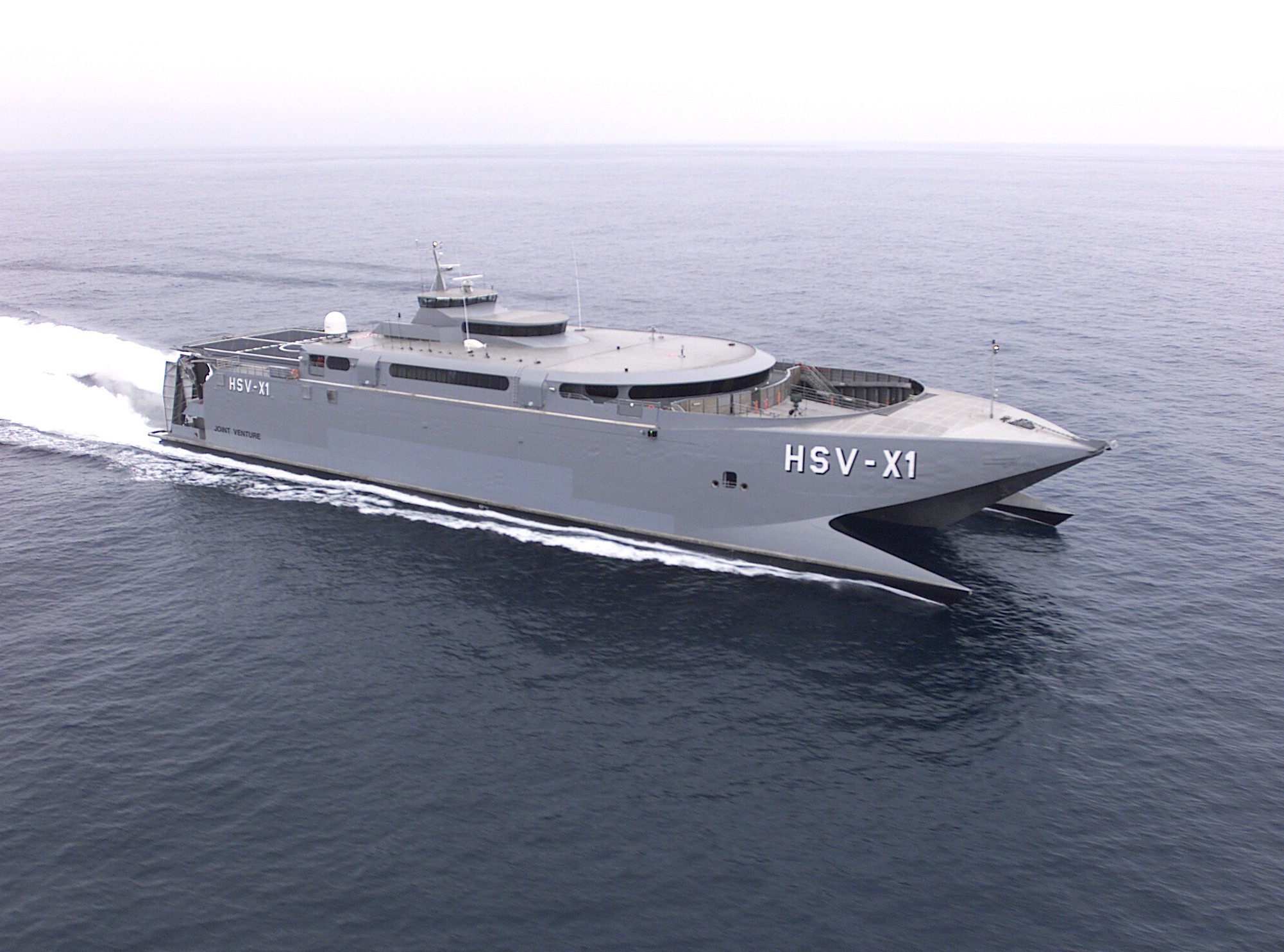
Manannan's chequered career included a five year charter initially to the United States Navy but transferred to the United States Army Forces between 2001-2006. The 5,029grt craft (see photo) was used for various trials and demonstrations and in which saw service in the Persian Gulf in support of 'Operation Iraqi Freedom' and in 2003 'Operation Enduring Freedom' in the Horn of Africa.

An engine plant of 4 x Caterpillars diesel generates a speed of over 40 knots / 46 mph which provided logistical solutions by the High-Speed Vessel (HSV) to transport troops and supplies covering long distances in support of the Combined Joint Task Force.

Other tasks required by the force included the roles of operating as a mobile command centre which entailed working closely inshore and operating as a helicopter carrier. Helicopters landed at the craft's stern positioned helicopter landing deck.

The military role of the craft is in stark contrast compared to when the 96m ferry was launched in 1998 for civilian purposes as the Incat 050, the number representing the number of pioneering wave-piercing craft built by InCat in Hobart, Tasmania.

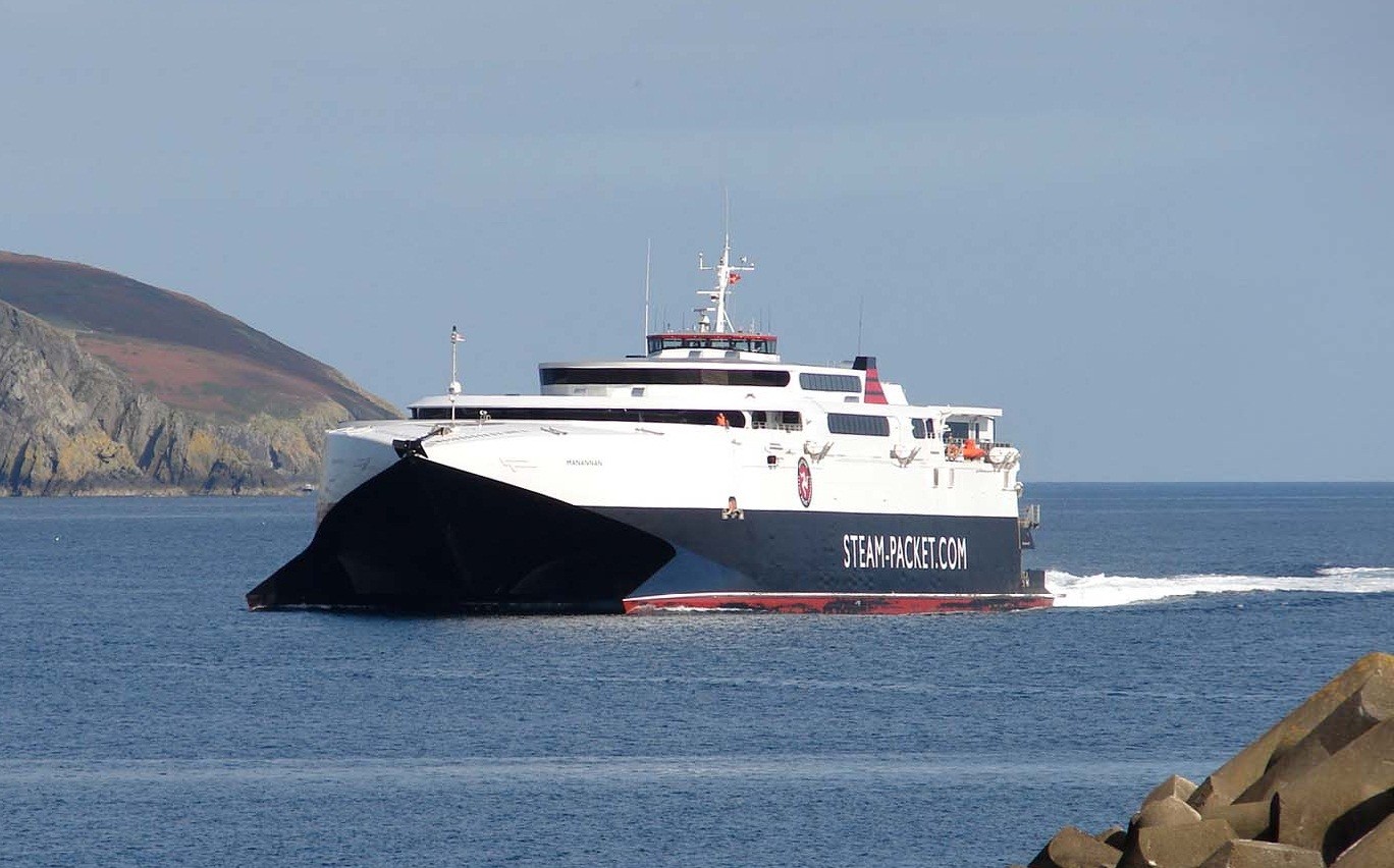
Asides her military days the 800-passenger / 200 vehicle fast-ferry has served the Hobart-Melbourne route, between New Zealand's north and south island and in European waters in the Mediterrean and to the Canary Islands.

Manannan (see photo) entered service last May after the Isle of Man Steam Packet Company (IOMSPco) purchased the vessel which was laid-up in Hobart. She made the long delivery to the northern hemisphere and was re-converted for ferry usesage during a refit in Portsmouth.

The 181 year-old company is the only sea-based passenger operator to the island on services linking Dublin, Belfast, Heysham, Liverpool and (Birkenhead) in the winter months.

There are rival companies such as the Ramsey Steamship Company but they are freight-only operators mostly running to Belfast and Liverpool using short-sea coastal traders and to other small Irish Sea ports.

An annual round island cruise is held and like last year the Manannan will be serving the cruise on Sunday 1 May departing Douglas at 11am for a journey of around 2 hours. The route closely circumnavigates the spectacular Manx coastline. For information on the island cruise and fares click here.

Published in Ferry

Dublin Bay

Dublin Bay on the east coast of Ireland stretches over seven kilometres, from Howth Head on its northern tip to Dalkey Island in the south. It's a place most Dubliners simply take for granted, and one of the capital's least visited places. But there's more going on out there than you'd imagine.

The biggest boating centre is at Dun Laoghaire Harbour on the Bay's south shore that is home to over 1,500 pleasure craft, four waterfront yacht clubs and Ireland's largest marina.

The bay is rather shallow with many sandbanks and rocky outcrops, and was notorious in the past for shipwrecks, especially when the wind was from the east. Until modern times, many ships and their passengers were lost along the treacherous coastline from Howth to Dun Laoghaire, less than a kilometre from shore.

The Bay is a C-shaped inlet of the Irish Sea and is about 10 kilometres wide along its north-south base, and 7 km in length to its apex at the centre of the city of Dublin; stretching from Howth Head in the north to Dalkey Point in the south. North Bull Island is situated in the northwest part of the bay, where one of two major inshore sandbanks lie, and features a 5 km long sandy beach, Dollymount Strand, fronting an internationally recognised wildfowl reserve. Many of the rivers of Dublin reach the Irish Sea at Dublin Bay: the River Liffey, with the River Dodder flow received less than 1 km inland, River Tolka, and various smaller rivers and streams.

Dublin Bay FAQs

There are approximately ten beaches and bathing spots around Dublin Bay: Dollymount Strand; Forty Foot Bathing Place; Half Moon bathing spot; Merrion Strand; Bull Wall; Sandycove Beach; Sandymount Strand; Seapoint; Shelley Banks; Sutton, Burrow Beach

There are slipways on the north side of Dublin Bay at Clontarf, Sutton and on the southside at Dun Laoghaire Harbour, and in Dalkey at Coliemore and Bulloch Harbours.

Dublin Bay is administered by a number of Government Departments, three local authorities and several statutory agencies. Dublin Port Company is in charge of navigation on the Bay.

Dublin Bay is approximately 70 sq kilometres or 7,000 hectares. The Bay is about 10 kilometres wide along its north-south base, and seven km in length east-west to its peak at the centre of the city of Dublin; stretching from Howth Head in the north to Dalkey Point in the south.

Dun Laoghaire Harbour on the southside of the Bay has an East and West Pier, each one kilometre long; this is one of the largest human-made harbours in the world. There also piers or walls at the entrance to the River Liffey at Dublin city known as the Great North and South Walls. Other harbours on the Bay include Bulloch Harbour and Coliemore Harbours both at Dalkey.

There are two marinas on Dublin Bay. Ireland's largest marina with over 800 berths is on the southern shore at Dun Laoghaire Harbour. The other is at Poolbeg Yacht and Boat Club on the River Liffey close to Dublin City.

Car and passenger Ferries operate from Dublin Port to the UK, Isle of Man and France. A passenger ferry operates from Dun Laoghaire Harbour to Howth as well as providing tourist voyages around the bay.

Dublin Bay has two Islands. Bull Island at Clontarf and Dalkey Island on the southern shore of the Bay.

The River Liffey flows through Dublin city and into the Bay. Its tributaries include the River Dodder, the River Poddle and the River Camac.

Dollymount, Burrow and Seapoint beaches

Approximately 1,500 boats from small dinghies to motorboats to ocean-going yachts. The vast majority, over 1,000, are moored at Dun Laoghaire Harbour which is Ireland's boating capital.

In 1981, UNESCO recognised the importance of Dublin Bay by designating North Bull Island as a Biosphere because of its rare and internationally important habitats and species of wildlife. To support sustainable development, UNESCO’s concept of a Biosphere has evolved to include not just areas of ecological value but also the areas around them and the communities that live and work within these areas. There have since been additional international and national designations, covering much of Dublin Bay, to ensure the protection of its water quality and biodiversity. To fulfil these broader management aims for the ecosystem, the Biosphere was expanded in 2015. The Biosphere now covers Dublin Bay, reflecting its significant environmental, economic, cultural and tourism importance, and extends to over 300km² to include the bay, the shore and nearby residential areas.

On the Southside at Dun Laoghaire, there is the National Yacht Club, Royal St. George Yacht Club, Royal Irish Yacht Club and Dun Laoghaire Motor Yacht Club as well as Dublin Bay Sailing Club. In the city centre, there is Poolbeg Yacht and Boat Club. On the Northside of Dublin, there is Clontarf Yacht and Boat Club and Sutton Dinghy Club. While not on Dublin Bay, Howth Yacht Club is the major north Dublin Sailing centre.

© Afloat 2020