Displaying items by tag: Cork coast
An ESB partnership aims to develop large scale storage for “green hydrogen” off the Cork coast which could meet up to ten per cent of current annual electricity consumption in Ireland.
Up to three terawatt-hours (TWh) of “green hydrogen” and hydrogen carriers could be stored if the project is licensed and given planning approval, ESB and dCarbonX have said.
“Green hydrogen” is produced by using renewable electricity such as wind to split water into its basic elements of hydrogen and oxygen.
“Green hydrogen” is described as a carbon-free gas that can be safely stored and used as a replacement fuel for heavy transport, shipping, industry and backup power generation.
“Decarbonising the electricity network and achieving Ireland’s goal of net-zero carbon by 2050 requires the large-scale development of green hydrogen from renewable sources,” the two companies have said.
This new project off Kinsale, Co Cork, with dCarbonX is one of several to identify and develop subseas energy storage offshore opportunities in Ireland.
Several months ago, the ESB announced plans to invest in a hydrogen facility as part of its redevelopment of the Moneypoint site in Clare into a renewable energy hub.
The companies have also proposed the development of a new “green hydrogen valley” around the Poolbeg peninsula in Dublin
The ESB says a proprietary evaluation of the depleted gas field reservoir around Kinsale took place earlier this year to identify the potential for large-scale storage of green hydrogen.
“Since then, a comprehensive work programme has begun, comprising subsurface analysis, mineralogy, capacity modelling, injection and withdrawal rates, compression, drilling evaluation, well design, retention assurance, monitoring, electrolysis and infrastructure tie-in,” the ESB says.
“Mirroring developments across Europe and globally, ESB recognises the role hydrogen will play in enabling a low carbon future,” ESB strategy manager for generation and trading Padraig O’Hiceadha said.
“Transforming sites – such as the recently decommissioned gas reservoirs at Kinsale Head – and repurposing reservoirs for green hydrogen can deliver large-scale sustainable energy storage for homes and businesses in the future,” he said.
“The Kinsale Head reservoirs hosted safe, secure and reliable offshore natural gas subsurface energy storage for many years, underpinning Ireland’s security of gas supply,” Dr John O’Sullivan, chief operating officer of dCarbonX, said
“Kinsale Head is the third Irish offshore location that we are assessing with ESB for green hydrogen storage and we look forward to providing further updates as appropriate,” O’Sullivan said.
The two companies said that the county Cork region is “ideally placed to be a renewable energy hub, having one of the largest natural harbours in the world”.
They have also highlighted Cork’s “excellent energy and transport connectivity, modern global manufacturing and service industries together with power stations, refinery and gas reception terminal”.
dCarbonX Ltd is a geo-energy company based in Dublin and London, which was established to develop subsurface hydrogen storage, carbon sequestration and geothermal baseload assets as part of the energy transition.
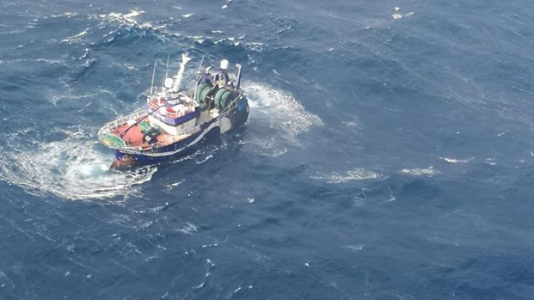
An Irish Naval Service vessel it is hoped to get a tow aboard a trawler stranded off the Cork coast with a crew of seven on board on Saturday morning.
The Wexford-registered trawler, Ellie Adhamh, lost power early on Friday morning 130km off the Bull Rock in west Cork while returning from a prawn fishing trip in the Porcupine Bank.
A major rescue operation was launched involving the Irish Coast Guard and the Naval Service and co-ordinated by the Irish Coast Guard Marine Rescue Co-ordination Centre at Valentia Island.
Force 4 westerly winds were whipping up big seas and a plan by a Bere Island tug, to go to assist the fishing vessel had to be abandoned after it was damaged by a large wave.
The Irish Coast Guard helicopter Rescue 115 from Shannon was then tasked to assist and proceeded to the scene but the captain and his crew opted to remain on the stricken fishing vessel.
Further reading reports The Irish Times.
Statement from the Coastguard issued at 12.30 on March 27 2021
Coast Guard co-ordinate rescue operation for trawler off Cork Coast
A fishing vessel that suffered a loss of power is being towed towards Bantry by the Naval ship LE George Bernard Shaw. The fishing vessel the ELLIE ADHAMH suffered a loss of power approximately 70 miles West of Bantry Bay on Friday morning and has been adrift .
The response is being coordinated by the Coast Guard Rescue Coordination centre at Valentia who initially tasked a Coast Guard Helicopter to the scene. The crew declined an offer to have some of the crew evacuated from the vessel.
The situation was monitored overnight by Valentia with the LE George Bernard Shaw on scene from 9 pm last night. Weather conditions overnight were challenging but the crew are reported to be in good spirits. The Castletownbere RNLI Lifeboat was also alerted and is monitoring the tow. A Coast Guard helicopter also transferred water pumps onto the vessel owing to the loss of power on the vessel.
Tow is proceeding satisfactorily and is expected to reach Bantry Bay later this evening where arrangements will be made to have the vessel taken into port.
Sailor Rescued from Burning Boat off Cork Coast
Youghal and Ballycotton lifeboat stations responded to the call and Ballycotton lifeboat station spoke of how they could see the black smoke in the distance as they rushed to the lifeboat station. An angling boat in the vicinity recovered the lone sailor from the sea. He was transferred to another angling boat and was immediately taken to Youghal where his condition was assessed by medical personnel.
Youghal and Ballycotton lifeboats were requested by the Coastguard to remain on scene while the pleasure craft blazed. Approximately an hour later the boat sank and the lifeboats returned to station.
Related Safety posts
RNLI Lifeboats in Ireland
Safety News
Rescue News from RNLI Lifeboats in Ireland
Coast Guard News from Ireland
Water Safety News from Ireland
Marine Casualty Investigation Board News
Marine Warnings


