Menu

Ireland's sailing, boating & maritime magazine

Dublin Bay Boating News and Information

Displaying items by tag: Creidne

#IRISH TALLSHIPS – Of the 40-plus tallships participating in the Dublin Tallships Race Festival, only two vessels are Irish, and as previously reported on Afloat.ie, there have been calls to have a new cross-border national sail training flagship reinstated, writes Jehan Ashmore.

What represents Ireland, are not large A-class tallships but smaller vessels in the form of the Naval Reserve training Bermuda ketch STV Creidne (C-class) and the Kinsale based schooner Spirit of Oysterhaven (D-class), which sailed through Dalkey Sound yesterday morning.

It is a stark contrast to the glory days of when the Irish tallships, met together for a historic first and only gathering at the inaugural Waterford Tall Ships Race Festival back in 2006. The tallship trio were brigantine Asgard II (which sank in 2008) and the barques Dunbrody and Jeanie Johnston.

The unique gathering took place during the 'Parade of Sail' in Waterford Estuary, where Asgard II was given the honour in leading the fleet, followed by her fellow Irish fleetmates and the rest of the international flotilla.

Both the replica 19th century Dunbrody and Jeanie Johnston remain in a static role in New Ross, Co. Wexford and in Dublin Docklands, where they serve as floating museums, telling the story of emigration and the famine ships.

During the Dublin Tallships Festival, the Jeanie Johnston will be open to the public free of charge throughout the weekend from 10am to 5pm (last entry) and is on a first come first basis.

Entry to the barque is courtesy of Dublin Docklands Development Authority which purchased the vessel in 2005. For further information visit: www.jeaniejohnston.ie/index.html

Published in Tall Ships
20th October 2011

Creidne Sail Training Scheme

The Naval Service's Sailing Training Vessel Creidne cuts a great pose sailing in Cork Harbour on page three of the Autumn issue of Afloat. The refurbished 47-footer is now in full use by the Naval Service as a training vessel for naval personnel and is consequently a common sight sailing off the Haulbowline base.

creidne

No Sail Training Programme because of Government cut backs

Although Creidne, built in 1967, undertook a limited sail training cruise programme in 2009, the programme was shelved when Creidne became a casualty of the Government's decision to discontinue the Sail Training Scheme operated by Coiste an Asgard.  The Defence Forces have asked us to point out that the sail training programme, that took up to eight trainees, has been stopped even if the Autumn Afloat article may have given the impression that the Creidne is still carrying out this function. Apologies for any confusion.
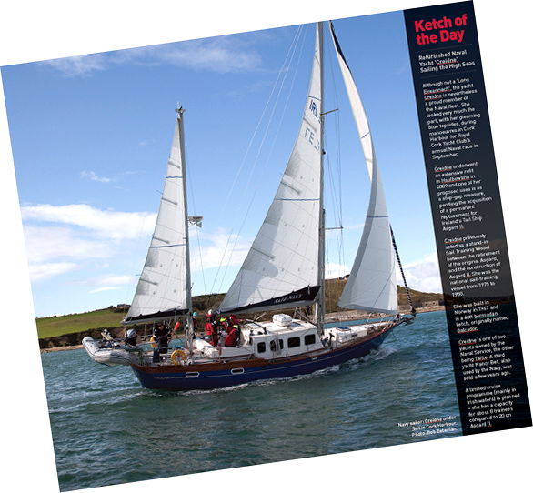
Creidne sailing gallery here


Published in Navy

Although not a 'Long Eireannach', the yacht Creidne is nevertheless a proud member of the Naval fleet. She looked very much the part, with her gleaming blue topsides, during manouvers in Cork Harbour for Royal Cork Yacht Club's annual Naval race last Sunday. PHOTOS BELOW BY BOB BATEMAN.

Creidne underwent an extensive refit in Haulbowline in 2009 and one of her proposed uses is as a stopgap measure, pending the acquisition of a permanent replacement for Ireland's Tall Ship Asgard II.

_DSC4726

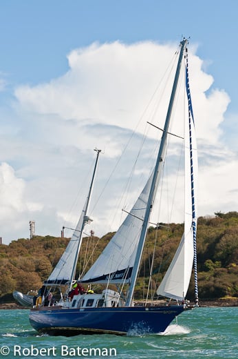
Creidne under Sail. Photo: Bob Bateman. More photos below

Creidne previously acted as a stand in Sail Training Vessel between the retirement of the original Asgard, and the construction of Asgard II. She was the national sail-training vessel from 1975 to 1980.

She was built in Norway in 1967 and is a 48 ft bermudan ketch, originally named Galcador.

Creidne is one of two yachts owned by the Naval Service, the other being Tailte. (Also pictured below). A third yacht Nancy Bet, also used by the Navy, was sold a few years ago.

A limited cruise programme (mainly in Irish waters) is planned, she has a capacity for about 8 trainees compared to 20 on Asgard II.

Published in Tall Ships

Dublin Bay

Dublin Bay on the east coast of Ireland stretches over seven kilometres, from Howth Head on its northern tip to Dalkey Island in the south. It's a place most Dubliners simply take for granted, and one of the capital's least visited places. But there's more going on out there than you'd imagine.

The biggest boating centre is at Dun Laoghaire Harbour on the Bay's south shore that is home to over 1,500 pleasure craft, four waterfront yacht clubs and Ireland's largest marina.

The bay is rather shallow with many sandbanks and rocky outcrops, and was notorious in the past for shipwrecks, especially when the wind was from the east. Until modern times, many ships and their passengers were lost along the treacherous coastline from Howth to Dun Laoghaire, less than a kilometre from shore.

The Bay is a C-shaped inlet of the Irish Sea and is about 10 kilometres wide along its north-south base, and 7 km in length to its apex at the centre of the city of Dublin; stretching from Howth Head in the north to Dalkey Point in the south. North Bull Island is situated in the northwest part of the bay, where one of two major inshore sandbanks lie, and features a 5 km long sandy beach, Dollymount Strand, fronting an internationally recognised wildfowl reserve. Many of the rivers of Dublin reach the Irish Sea at Dublin Bay: the River Liffey, with the River Dodder flow received less than 1 km inland, River Tolka, and various smaller rivers and streams.

Dublin Bay FAQs

There are approximately ten beaches and bathing spots around Dublin Bay: Dollymount Strand; Forty Foot Bathing Place; Half Moon bathing spot; Merrion Strand; Bull Wall; Sandycove Beach; Sandymount Strand; Seapoint; Shelley Banks; Sutton, Burrow Beach

There are slipways on the north side of Dublin Bay at Clontarf, Sutton and on the southside at Dun Laoghaire Harbour, and in Dalkey at Coliemore and Bulloch Harbours.

Dublin Bay is administered by a number of Government Departments, three local authorities and several statutory agencies. Dublin Port Company is in charge of navigation on the Bay.

Dublin Bay is approximately 70 sq kilometres or 7,000 hectares. The Bay is about 10 kilometres wide along its north-south base, and seven km in length east-west to its peak at the centre of the city of Dublin; stretching from Howth Head in the north to Dalkey Point in the south.

Dun Laoghaire Harbour on the southside of the Bay has an East and West Pier, each one kilometre long; this is one of the largest human-made harbours in the world. There also piers or walls at the entrance to the River Liffey at Dublin city known as the Great North and South Walls. Other harbours on the Bay include Bulloch Harbour and Coliemore Harbours both at Dalkey.

There are two marinas on Dublin Bay. Ireland's largest marina with over 800 berths is on the southern shore at Dun Laoghaire Harbour. The other is at Poolbeg Yacht and Boat Club on the River Liffey close to Dublin City.

Car and passenger Ferries operate from Dublin Port to the UK, Isle of Man and France. A passenger ferry operates from Dun Laoghaire Harbour to Howth as well as providing tourist voyages around the bay.

Dublin Bay has two Islands. Bull Island at Clontarf and Dalkey Island on the southern shore of the Bay.

The River Liffey flows through Dublin city and into the Bay. Its tributaries include the River Dodder, the River Poddle and the River Camac.

Dollymount, Burrow and Seapoint beaches

Approximately 1,500 boats from small dinghies to motorboats to ocean-going yachts. The vast majority, over 1,000, are moored at Dun Laoghaire Harbour which is Ireland's boating capital.

In 1981, UNESCO recognised the importance of Dublin Bay by designating North Bull Island as a Biosphere because of its rare and internationally important habitats and species of wildlife. To support sustainable development, UNESCO’s concept of a Biosphere has evolved to include not just areas of ecological value but also the areas around them and the communities that live and work within these areas. There have since been additional international and national designations, covering much of Dublin Bay, to ensure the protection of its water quality and biodiversity. To fulfil these broader management aims for the ecosystem, the Biosphere was expanded in 2015. The Biosphere now covers Dublin Bay, reflecting its significant environmental, economic, cultural and tourism importance, and extends to over 300km² to include the bay, the shore and nearby residential areas.

On the Southside at Dun Laoghaire, there is the National Yacht Club, Royal St. George Yacht Club, Royal Irish Yacht Club and Dun Laoghaire Motor Yacht Club as well as Dublin Bay Sailing Club. In the city centre, there is Poolbeg Yacht and Boat Club. On the Northside of Dublin, there is Clontarf Yacht and Boat Club and Sutton Dinghy Club. While not on Dublin Bay, Howth Yacht Club is the major north Dublin Sailing centre.

© Afloat 2020