Menu

Ireland's sailing, boating & maritime magazine

Dublin Bay Boating News and Information

Displaying items by tag: Decarbonisation

Dublin Port Company is recruiting for the role of energy and decarbonisation lead.

The State-owned commercial port says it “aims to play a strong role in achieving its own energy and decarbonisation goals, as well as supporting and influencing wider Dublin Port stakeholders in meeting their own energy reduction and decarbonisation ambitions”.

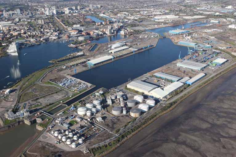
Dublin Port has 15,000 annual vessel movements, handles almost half of the Republic of Ireland’s trade, is the largest freight and passenger port in Ireland and is one of five major ports classified as Tier 1/Tier 2 ports in the National Ports Policy.

The energy and decarbonisation lead will head the development, implementation and delivery of plans to ensure that Dublin Port Company meets its energy and decarbonisation goals and commitments.

As the company provides critical national port infrastructure, the role will require a close working relationship with its stakeholders to ensure it understands their decarbonisation needs, in order to best support them in meeting their energy and decarbonisation goals.

The role will require leading the energy and decarbonisation team, especially working closely with the port’s technical manager, property and facilities manager and assistant harbour master, who are all key members of that team.

Key responsibilities also include work within energy and decarbonisation management, the NewERA Climate Action Framework for the Commercial Semi-State Sector, Dublin Port Energy & Decarbonisation Community, infrastructure and more.

Must-have requirements include a FETAC Level 8 undergraduate degree qualification in energy, environment, sustainability or an engineering discipline; a minimum of five years’ industry experience and ability to demonstrate competent knowledge in the fields of energy or sustainability; and management system experience (eg ISO 9001/14001/50001).

Those interested can find further information and apply for the position via LinkedIn HERE.

Published in Jobs

Several ports in south Wales and all operated by Associated British Ports (ABP) have launched an ambitious plan to decarbonise the region with its Future Ports for Wales Vision.

ABP has five ports in south Wales, (from west to east) Swansea, Port Talbot, Barry, Cardiff (above) and Newport. According to ABP, the sea change strategy outlines a decarbonised future and now the focus is on Port Talbot in west Glamorgan.

Together the ports played a key role in the creation of the modern industrial world and looking ahead, ABP recognises they will now need to play a pivotal role in Wales’ transition to a low carbon economy.

During the Future ports: Wales vision launch Andrew Harston, Director ABP Wales and Short Sea Ports said: “We need to imagine a changed world, understand its opportunities, and focus on the outcomes we need. We cannot make hard and fast predictions, but we can sketch the outlines of what needs doing. We need a new approach to realise the huge potential of Wales’ strategic port locations; to build the foundations of a new cycle of innovation and prosperity and time is of the essence.”

One of the key opportunities ABP is keen to seize is the potential to create a floating offshore wind (FLOW) centre of excellence in the Celtic Sea. The Port of Port Talbot is well positioned to do so and has the deep waters required. Port Talbot also has brownfield land ready for development, excellent rail connections, proximity to steel, marine and aggregates and access to thousands of skilled workers.

The port of Port Talbot is currently predominantly used for imports of coking coal, minerals and ores for Tate Steel. ABP plans to work with the steel giant and others to make its vision a reality.

Chairman of the Tata Steel UK board, Sandip Biswas, said: “The port is a vital connection for us allowing the direct import of raw materials for steelmaking.

We are excited to see ABP developing its vision for the future and look forward to working closely with ABP to realise these plans. It is only by working together in partnership that we can all develop a better, more sustainable, world for the future.”

Simon Brown, Divisional Port Manager for Wales & South West at ABP said: “We know that ports can’t make the changes alone. It will be necessary to develop a shared vision based on new ways of working between business, government, academia and communities. Greater collaboration will make sure that we share risks, rewards, and intelligence, and deliver better outcomes for the economy, the environment and our societies.”

For more information on ABP’s Vision and how the concepts might be implemented at port level visit here. 

Published in Ports & Shipping

Dublin Bay

Dublin Bay on the east coast of Ireland stretches over seven kilometres, from Howth Head on its northern tip to Dalkey Island in the south. It's a place most Dubliners simply take for granted, and one of the capital's least visited places. But there's more going on out there than you'd imagine.

The biggest boating centre is at Dun Laoghaire Harbour on the Bay's south shore that is home to over 1,500 pleasure craft, four waterfront yacht clubs and Ireland's largest marina.

The bay is rather shallow with many sandbanks and rocky outcrops, and was notorious in the past for shipwrecks, especially when the wind was from the east. Until modern times, many ships and their passengers were lost along the treacherous coastline from Howth to Dun Laoghaire, less than a kilometre from shore.

The Bay is a C-shaped inlet of the Irish Sea and is about 10 kilometres wide along its north-south base, and 7 km in length to its apex at the centre of the city of Dublin; stretching from Howth Head in the north to Dalkey Point in the south. North Bull Island is situated in the northwest part of the bay, where one of two major inshore sandbanks lie, and features a 5 km long sandy beach, Dollymount Strand, fronting an internationally recognised wildfowl reserve. Many of the rivers of Dublin reach the Irish Sea at Dublin Bay: the River Liffey, with the River Dodder flow received less than 1 km inland, River Tolka, and various smaller rivers and streams.

Dublin Bay FAQs

There are approximately ten beaches and bathing spots around Dublin Bay: Dollymount Strand; Forty Foot Bathing Place; Half Moon bathing spot; Merrion Strand; Bull Wall; Sandycove Beach; Sandymount Strand; Seapoint; Shelley Banks; Sutton, Burrow Beach

There are slipways on the north side of Dublin Bay at Clontarf, Sutton and on the southside at Dun Laoghaire Harbour, and in Dalkey at Coliemore and Bulloch Harbours.

Dublin Bay is administered by a number of Government Departments, three local authorities and several statutory agencies. Dublin Port Company is in charge of navigation on the Bay.

Dublin Bay is approximately 70 sq kilometres or 7,000 hectares. The Bay is about 10 kilometres wide along its north-south base, and seven km in length east-west to its peak at the centre of the city of Dublin; stretching from Howth Head in the north to Dalkey Point in the south.

Dun Laoghaire Harbour on the southside of the Bay has an East and West Pier, each one kilometre long; this is one of the largest human-made harbours in the world. There also piers or walls at the entrance to the River Liffey at Dublin city known as the Great North and South Walls. Other harbours on the Bay include Bulloch Harbour and Coliemore Harbours both at Dalkey.

There are two marinas on Dublin Bay. Ireland's largest marina with over 800 berths is on the southern shore at Dun Laoghaire Harbour. The other is at Poolbeg Yacht and Boat Club on the River Liffey close to Dublin City.

Car and passenger Ferries operate from Dublin Port to the UK, Isle of Man and France. A passenger ferry operates from Dun Laoghaire Harbour to Howth as well as providing tourist voyages around the bay.

Dublin Bay has two Islands. Bull Island at Clontarf and Dalkey Island on the southern shore of the Bay.

The River Liffey flows through Dublin city and into the Bay. Its tributaries include the River Dodder, the River Poddle and the River Camac.

Dollymount, Burrow and Seapoint beaches

Approximately 1,500 boats from small dinghies to motorboats to ocean-going yachts. The vast majority, over 1,000, are moored at Dun Laoghaire Harbour which is Ireland's boating capital.

In 1981, UNESCO recognised the importance of Dublin Bay by designating North Bull Island as a Biosphere because of its rare and internationally important habitats and species of wildlife. To support sustainable development, UNESCO’s concept of a Biosphere has evolved to include not just areas of ecological value but also the areas around them and the communities that live and work within these areas. There have since been additional international and national designations, covering much of Dublin Bay, to ensure the protection of its water quality and biodiversity. To fulfil these broader management aims for the ecosystem, the Biosphere was expanded in 2015. The Biosphere now covers Dublin Bay, reflecting its significant environmental, economic, cultural and tourism importance, and extends to over 300km² to include the bay, the shore and nearby residential areas.

On the Southside at Dun Laoghaire, there is the National Yacht Club, Royal St. George Yacht Club, Royal Irish Yacht Club and Dun Laoghaire Motor Yacht Club as well as Dublin Bay Sailing Club. In the city centre, there is Poolbeg Yacht and Boat Club. On the Northside of Dublin, there is Clontarf Yacht and Boat Club and Sutton Dinghy Club. While not on Dublin Bay, Howth Yacht Club is the major north Dublin Sailing centre.

© Afloat 2020