Menu

Ireland's sailing, boating & maritime magazine

Dublin Bay Boating News and Information

Displaying items by tag: Diver

At the end of March, the Strangford and Lecale Partnership started a new pilot study of Advanced Mooring Systems in Strangford Lough. It is the first study of its kind in Northern Ireland, and these eco-friendly moorings will avoid or limit the damage caused to the seafloor habitats and species by the swinging chain of traditional boat moorings.

The Partnership covers the whole of the Strangford and Lecale Area of Outstanding Natural Beauty, taking in much of the Ards Peninsula, Strangford Lough and Lecale. It brings together statutory authorities to improve heritage management across the whole of the area and is underpinned by the Department of the Environment, Northern Ireland Environment Agency, Newry Mourne and Down District Council and Ards and North Down Borough Council.

The Sterling mooring system uses floats to keep the chain off the seabed

Two different types of advanced mooring systems were installed in Ballyhenry Bay following condition assessments of the Seagrass around the existing swinging chain moorings. The site is just north of Portaferry on the eastern shore of the Lough near the Narrows.

A Seaflex Mooring unit about to be deployedA Seaflex Mooring unit about to be deployed

The diver video recorded the seagrass condition around the entire circumference of the mooring, the old mooring was removed and the new mooring installed.

The two different systems being trialled are Seaflex, an elastic and environmentally friendly mooring solution and Sterling which uses floats to keep the chain off the seabed.

The area will be resurveyed next year to see which has been more successful in allowing the seagrass to re-establish. This work is being carried out by Cuan Marine Services Ltd, in partnership with local mooring owners, and funded through the NIEA Challenge Fund. This fund supports the Water Quality Improvement Strand of the Environmental Challenge Fund which seeks to support projects that help people connect with and seek improvements to their local aquatic environment.

Cuan Marine Services are carrying out the Strangford Lough studyCuan Marine Services are carrying out the Strangford Lough study

Cuan Marine Services were employed by Newry Mourne and Down District Council to deliver a feasibility study ‘Potential for advanced-moorings as management option for Strangford Lough Marine Protected Areas (MPA)’

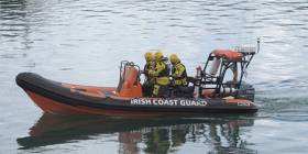
This afternoon the Irish Coast Guard were alerted to concerns for a diver who was at the slip at Howth Harbour, Co Dublin.

The local Coast Guard unit in Howth were tasked and were quickly on scene.

On arrival the team were met with a male diver in his 40s who had experienced a rapid ascent while returning to the surface from 15 meters depth. With the possibility of decompression sickness the Coast Guard team provided medical assistance until the arrival of an ambulance.

The casualty was taken to Beaumont Hospital where his condition is stable.

Published in Coastguard

#rnil – As Afloat.ie reported earlier Crosshaven Lifeboat were paged at 6.08pm (14 June) to a Dive Boat near Roches Point with an unresponsive diver on Board. The lifeboat met with the Dive Boat off Fort Camden and transferred volunteer Ian Venner, who immediately took over first Aid. The lifeboat was met ashore by Dr John Murphy and Crosshaven Coast Guard. First Aid continued until the patient was handed over to the ambulance service. Helicopter Rescue 117 from Waterford was also tasked.

Sadly, the diver later died in Cork University Hospital. Our Sympathies go to his Family and Friends.

Published in RNLI Lifeboats
Tagged under
It's that time of year again, dark evenings and looking for a new challenge writes Timmy Carey. Time to find a new sport to take away the winter blues, why not try SCUBA Diving or Snorkelling. Most clubs begin training either in October or February so now is the best time to enquire and give it a try. The shores of Ireland are blessed with a rich variety of marine life and with almost 12,000 shipwrecks around our coast, there is an never ending challenge awaiting. The Irish Underwater Council has almost 100 diving clubs clubs across Ireland affiliated to it and most will be running beginners scuba courses shortly. For further details log in HERE or alternatively ring the Irish Underwater Council head office at 01-2844601

 diveMG_0558

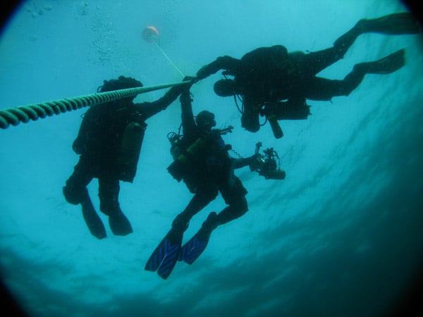
Divers completing a decompression stop after a 40 meter dive to the wreck of the ssFoilia off the Waterford Coast

Published in Diving

Dublin Bay

Dublin Bay on the east coast of Ireland stretches over seven kilometres, from Howth Head on its northern tip to Dalkey Island in the south. It's a place most Dubliners simply take for granted, and one of the capital's least visited places. But there's more going on out there than you'd imagine.

The biggest boating centre is at Dun Laoghaire Harbour on the Bay's south shore that is home to over 1,500 pleasure craft, four waterfront yacht clubs and Ireland's largest marina.

The bay is rather shallow with many sandbanks and rocky outcrops, and was notorious in the past for shipwrecks, especially when the wind was from the east. Until modern times, many ships and their passengers were lost along the treacherous coastline from Howth to Dun Laoghaire, less than a kilometre from shore.

The Bay is a C-shaped inlet of the Irish Sea and is about 10 kilometres wide along its north-south base, and 7 km in length to its apex at the centre of the city of Dublin; stretching from Howth Head in the north to Dalkey Point in the south. North Bull Island is situated in the northwest part of the bay, where one of two major inshore sandbanks lie, and features a 5 km long sandy beach, Dollymount Strand, fronting an internationally recognised wildfowl reserve. Many of the rivers of Dublin reach the Irish Sea at Dublin Bay: the River Liffey, with the River Dodder flow received less than 1 km inland, River Tolka, and various smaller rivers and streams.

Dublin Bay FAQs

There are approximately ten beaches and bathing spots around Dublin Bay: Dollymount Strand; Forty Foot Bathing Place; Half Moon bathing spot; Merrion Strand; Bull Wall; Sandycove Beach; Sandymount Strand; Seapoint; Shelley Banks; Sutton, Burrow Beach

There are slipways on the north side of Dublin Bay at Clontarf, Sutton and on the southside at Dun Laoghaire Harbour, and in Dalkey at Coliemore and Bulloch Harbours.

Dublin Bay is administered by a number of Government Departments, three local authorities and several statutory agencies. Dublin Port Company is in charge of navigation on the Bay.

Dublin Bay is approximately 70 sq kilometres or 7,000 hectares. The Bay is about 10 kilometres wide along its north-south base, and seven km in length east-west to its peak at the centre of the city of Dublin; stretching from Howth Head in the north to Dalkey Point in the south.

Dun Laoghaire Harbour on the southside of the Bay has an East and West Pier, each one kilometre long; this is one of the largest human-made harbours in the world. There also piers or walls at the entrance to the River Liffey at Dublin city known as the Great North and South Walls. Other harbours on the Bay include Bulloch Harbour and Coliemore Harbours both at Dalkey.

There are two marinas on Dublin Bay. Ireland's largest marina with over 800 berths is on the southern shore at Dun Laoghaire Harbour. The other is at Poolbeg Yacht and Boat Club on the River Liffey close to Dublin City.

Car and passenger Ferries operate from Dublin Port to the UK, Isle of Man and France. A passenger ferry operates from Dun Laoghaire Harbour to Howth as well as providing tourist voyages around the bay.

Dublin Bay has two Islands. Bull Island at Clontarf and Dalkey Island on the southern shore of the Bay.

The River Liffey flows through Dublin city and into the Bay. Its tributaries include the River Dodder, the River Poddle and the River Camac.

Dollymount, Burrow and Seapoint beaches

Approximately 1,500 boats from small dinghies to motorboats to ocean-going yachts. The vast majority, over 1,000, are moored at Dun Laoghaire Harbour which is Ireland's boating capital.

In 1981, UNESCO recognised the importance of Dublin Bay by designating North Bull Island as a Biosphere because of its rare and internationally important habitats and species of wildlife. To support sustainable development, UNESCO’s concept of a Biosphere has evolved to include not just areas of ecological value but also the areas around them and the communities that live and work within these areas. There have since been additional international and national designations, covering much of Dublin Bay, to ensure the protection of its water quality and biodiversity. To fulfil these broader management aims for the ecosystem, the Biosphere was expanded in 2015. The Biosphere now covers Dublin Bay, reflecting its significant environmental, economic, cultural and tourism importance, and extends to over 300km² to include the bay, the shore and nearby residential areas.

On the Southside at Dun Laoghaire, there is the National Yacht Club, Royal St. George Yacht Club, Royal Irish Yacht Club and Dun Laoghaire Motor Yacht Club as well as Dublin Bay Sailing Club. In the city centre, there is Poolbeg Yacht and Boat Club. On the Northside of Dublin, there is Clontarf Yacht and Boat Club and Sutton Dinghy Club. While not on Dublin Bay, Howth Yacht Club is the major north Dublin Sailing centre.

© Afloat 2020