Displaying items by tag: Dublin dry dock
Jeanie Johnston Almost Home From Historic End of Era Dry-Docking
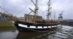
#DublinsTallship - Jeanie Johnston which became the final ever vessel to use Dublin Port's last working graving dock is to return to her usual city-centre berth this afternoon, writes Jehan Ashmore.
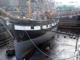
On Monday, the replica of a 19th century famine emigrant barque had departed the 200m graving dock having undergone planned maintenance.
The facility that also was a shiprepair and conversion business is to be decommissioned. Dublin Port are to in-fill the site for the Alexandra Basin Redevelopment ABR project. This will be phase one of the port’s Masterplan to permit largers ships to enter the port and expand capacity.
After been towed from drydock, Jeanie Johnston is currently at a temporary berth along the North Wall Quay Extension next to the Tom Clarke toll-bridge. The bascule-bridge lift is to be raised to facilitate the Jeanie Johnston by heading upriver.
Following this transit, Jeanie Johnston is not to directly head to her routine berth at Custom House Quay. Instead the barque will berth along Sir John Rogersons Quay. From this southside berth the tallship will await clearance subject to specific opening times, before making a transit through the Samuel Beckett swing-bridge.
Once this second transit has been achieved then the 301 gross tonnage tallship will finally reach her berth on the Liffey at Custom House Quay.
According to the operator's website, tours of the replica tallship are to begin this Friday. The original Jeanie Johnston completed 16 trans-Atlantic emigrant voyages between Ireland and north America in the years from 1847 to 1855. Over 2,500 people were transported and notably with no loss of life.
Jeanie Johnston Departs Dublin Port Graving Dock for Final Time
#PortHistory - Jeanie Johnston made history when at Dublin Port yesterday the tall ship floated out of its graving dock.
As the Irish Times writes the replica 19th century “Famine” ship is the last vessel to be worked on in the port’s graving dock as previously reported by Afloat. The dry-dock is being closed and filled in as part of the €230 million Alexandra Basin project.
The five-year project aims to allow larger ships to routinely call at Dublin, turn within Alexandra Basin and berth as far upriver as East Link Bridge.
Micheál Ó Cionna, who manages the Jeanie Johnston as a tourist attraction and museum, said the ship would return to its berth with Dublin Port tug assistance and would re-open later this week.
Mr Ó Cionna said the closure of the port graving dock emphasised the need for Minister for Heritage Heather Humphreys to save the last docks of this type in the Liffey area – on the Grand Canal Basin. For on this story click here.
Largest Working Dry Dock in State to 'Close Again' in Dublin Port
#DryDockClosure - The largest dry dock in the State and the last remaining working dry-dock (No. 2) in Dublin Port is to close marking an end of an era of our maritime heritage, writes Jehan Ashmore.
The 200m dry dock is where the replica tallship Jeanie Johnston is undergoing work, however according to RTE the Dublin Port Company said the reason for the closure is due to ships on the Irish Sea are too big to fit in the dry dock. The port company also cited ships already are been repaired in UK yards, though Afloat has reported on Arklow Shipping using Cork Dockyard albeit a smaller dry-dock.
DPC added they have expansion plans for the port which require infilling the dry dock as part of the €277m Alexandra Basin Redevelopment (ABR) project, see below. This will represent phase one of the port’s Masterplan: 2012-2040 to meet growing demands of trade and port infrastructure capacity.
Afloat adds that dry-dock had actually been ‘temporarily reopened’ by the port company. This was to facilitate ongoing work of the timber built Dublin based famine emigrant floating museum-ship, Jeanie Johnston. The visitor attraction located at a berth on the River Liffey is scheduled to reopen on 17th February.
The barque was last dry-docked at the same facility in 2014. So on this current occasion the Jeanie Johnston marks another chapter of Irish maritime marine engineering heritage as the last ever ship to dry-dock in the capital.
In April 2016 the dry-dock closed having been run by Dublin Graving Docks Ltd 'under licence' from Dublin Port Company. The shiprepairer, maintenance, conversion engineering facility closed with the loss of a skilled workforce of 26 personnel. The last ship to use the dry-dock under the licence arrangement was Arklow Fame. Likwise of the tallship the cargoship is Irish flagged.
A variety of vessels used the dry-dock mostly short-sea general cargoships, coasters, ro-ro freight ferries and supertrawlers. In addition the dry dock was a customer of the ports-owned fleet of tugs and workboats.
Following the closure last Spring of Dubin Graving Docks, the Maritime Institute of Ireland expressed the closure would result in work being lost to Ireland “with the lamentable decision to close and in-fill the big Dublin Graving Dock No.2 which was in constant use by Arklow Shipping”.
The graving dry-dock was opened 60 years by President Sean T.O’Kelly where at the unveiling ceremony in 1957 the new facility was heralded as an “iconic State-funded enterprise”.
As previously highlighted the DPC are to infill the drydock to create more quay space in Alexandra Basin. This will enable considerably larger deep drafted cargoships to enter the port. In addition to accommodate giant cruiseships by berthing much closer to the city-centre near the 3Arena. The ABR project will also feature the port's first dedicated cruise terminal. This will have two berths.
The rich maritime tradition of Dublin Port is however to become part of a new 'maritime industrial heritage' attraction site commented a port spokesperson. The site chosen will see DPC use a neighbouring disused dry-dock (No.1) which is much older. Afloat previously reported on the plans for dry dock dating to 1860’s.
Ironically in order to create this new heritage site, the stone-cut listed dry dock is to be excavated having only been infilled during the Celtic Tiger. This was to meet the growing demands for hard-standing vehicle space associated with a nearby ro-ro ferry terminal. This been located next to the Tom Clarke (East-Link) toll-lift bridge.
The disused dry-dock is also located beside the Port Centre, the headquarters of the Dublin Port Company. The site will be within a short walking distance of the new cruise terminal.
This area at the port entrance and headquarters is to be transformed as part of a ‘soft’ port remodelling of the architectural surroundings. Its purpose is to generate and engage a closer relationship between the port and the capital by bringing the public to interact between such spaces.


