Menu

Ireland's sailing, boating & maritime magazine

Dublin Bay Boating News and Information

Displaying items by tag: Dutch Navy Submarine

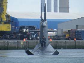
#X-Submarine - A Dutch navy non-nuclear powered submarine built during the Cold War is this afternoon arriving to Cork City for a four-day visit, writes Jehan Ashmore.

HNLMS Bruinvis is a diesel electric powered submarine. The 68m submarine is equipped with almost 40 torpedoes and is the final ‘Walrus’ class of four built. Leadship HNLMS Walrus visited Dublin Port earlier this year. 

On this occasion, the visit of the Royal Netherlands Navy (NATO member) submarine takes place at Cork city centre’s JJ Horgan's Wharf on the north quays. The crew are to spend their on leave time in the southern city for the purposes of rest and recreation.

What makes these class unusual to other submarines is the "X" tail configuration design. This involves in mounting four combined rudders and diving planes to form the an "X" tail at the stern (see above photo).This differs to the conventional cross-shaped assembly of stern diving planes and rudders.

The contract for the submarine was given to Rotterdamsche Droogdok Maatschappij (Rotterdam Dry Dock Co). Construction began in 1988, one year before the fall of the Berlin Wall and the end of the Cold War in 1991. Three years later HNLMS Brunis was commissioned into service. 


Published in Naval Visits

#SUBMARINE – A Dutch Navy submarine HNLMS Dolfijn arrived into Cork Harbour this morning, she is one of four 'Walrus' class which are among the modern sophisticated non-nuclear submarines in the world, writes Jehan Ashmore.

The Royal Netherlands Navy submarine which draws 7.5m draught berthed at Cork City's J.J. Horgan's Wharf which has a 8.8m depth. She is a sister of lead class submarine HNLMS Walrus which visited Dublin Port several years ago.

The class were built using stealth technologies making them invisible and very difficult to detect by ships, aircraft or other submarines when submerged. The submarines can remain submerged for long periods to carry out their missions.

'Walrus' class specifications: Length: 68 m Beam: 8.5 m Draught: 7.5 m Maximum diving depth: > 300 m Water displacement: 2,450 tonnes (surface), 2,800 tonnes (submerged) Propulsion diesel/electric: (3,132 kW) Maximum speed: 11 knots (surface), 20 knots (submerged) Ship's company: 55 Armament: MK 48 torpedoes

Dutch submarines in peacetime duties are used primarily for reconnaissance. During exercises, they are often used as targets for frigates and helicopters.

Should a nation not be cooperating with sanctions imposed by the international community, the submarines can contribute to enforcing the International sanctions. During the NATO Operation Allied Force, HNLMS Dolfijn helped to enforce the embargo off the coast of former Yugoslavia.

Among the other missions the submarines are involved include: collecting intelligence; conducting coast reconnaissance; laying sea mines and putting special forces from the Netherlands Marine Corps ashore.

On overseas deployments, for example HNMLS Dolfijn has patrolled in the Caribbean Sea with calls to the Netherlands Antilles capital of Willemstad.


Published in Naval Visits

Dublin Bay

Dublin Bay on the east coast of Ireland stretches over seven kilometres, from Howth Head on its northern tip to Dalkey Island in the south. It's a place most Dubliners simply take for granted, and one of the capital's least visited places. But there's more going on out there than you'd imagine.

The biggest boating centre is at Dun Laoghaire Harbour on the Bay's south shore that is home to over 1,500 pleasure craft, four waterfront yacht clubs and Ireland's largest marina.

The bay is rather shallow with many sandbanks and rocky outcrops, and was notorious in the past for shipwrecks, especially when the wind was from the east. Until modern times, many ships and their passengers were lost along the treacherous coastline from Howth to Dun Laoghaire, less than a kilometre from shore.

The Bay is a C-shaped inlet of the Irish Sea and is about 10 kilometres wide along its north-south base, and 7 km in length to its apex at the centre of the city of Dublin; stretching from Howth Head in the north to Dalkey Point in the south. North Bull Island is situated in the northwest part of the bay, where one of two major inshore sandbanks lie, and features a 5 km long sandy beach, Dollymount Strand, fronting an internationally recognised wildfowl reserve. Many of the rivers of Dublin reach the Irish Sea at Dublin Bay: the River Liffey, with the River Dodder flow received less than 1 km inland, River Tolka, and various smaller rivers and streams.

Dublin Bay FAQs

There are approximately ten beaches and bathing spots around Dublin Bay: Dollymount Strand; Forty Foot Bathing Place; Half Moon bathing spot; Merrion Strand; Bull Wall; Sandycove Beach; Sandymount Strand; Seapoint; Shelley Banks; Sutton, Burrow Beach

There are slipways on the north side of Dublin Bay at Clontarf, Sutton and on the southside at Dun Laoghaire Harbour, and in Dalkey at Coliemore and Bulloch Harbours.

Dublin Bay is administered by a number of Government Departments, three local authorities and several statutory agencies. Dublin Port Company is in charge of navigation on the Bay.

Dublin Bay is approximately 70 sq kilometres or 7,000 hectares. The Bay is about 10 kilometres wide along its north-south base, and seven km in length east-west to its peak at the centre of the city of Dublin; stretching from Howth Head in the north to Dalkey Point in the south.

Dun Laoghaire Harbour on the southside of the Bay has an East and West Pier, each one kilometre long; this is one of the largest human-made harbours in the world. There also piers or walls at the entrance to the River Liffey at Dublin city known as the Great North and South Walls. Other harbours on the Bay include Bulloch Harbour and Coliemore Harbours both at Dalkey.

There are two marinas on Dublin Bay. Ireland's largest marina with over 800 berths is on the southern shore at Dun Laoghaire Harbour. The other is at Poolbeg Yacht and Boat Club on the River Liffey close to Dublin City.

Car and passenger Ferries operate from Dublin Port to the UK, Isle of Man and France. A passenger ferry operates from Dun Laoghaire Harbour to Howth as well as providing tourist voyages around the bay.

Dublin Bay has two Islands. Bull Island at Clontarf and Dalkey Island on the southern shore of the Bay.

The River Liffey flows through Dublin city and into the Bay. Its tributaries include the River Dodder, the River Poddle and the River Camac.

Dollymount, Burrow and Seapoint beaches

Approximately 1,500 boats from small dinghies to motorboats to ocean-going yachts. The vast majority, over 1,000, are moored at Dun Laoghaire Harbour which is Ireland's boating capital.

In 1981, UNESCO recognised the importance of Dublin Bay by designating North Bull Island as a Biosphere because of its rare and internationally important habitats and species of wildlife. To support sustainable development, UNESCO’s concept of a Biosphere has evolved to include not just areas of ecological value but also the areas around them and the communities that live and work within these areas. There have since been additional international and national designations, covering much of Dublin Bay, to ensure the protection of its water quality and biodiversity. To fulfil these broader management aims for the ecosystem, the Biosphere was expanded in 2015. The Biosphere now covers Dublin Bay, reflecting its significant environmental, economic, cultural and tourism importance, and extends to over 300km² to include the bay, the shore and nearby residential areas.

On the Southside at Dun Laoghaire, there is the National Yacht Club, Royal St. George Yacht Club, Royal Irish Yacht Club and Dun Laoghaire Motor Yacht Club as well as Dublin Bay Sailing Club. In the city centre, there is Poolbeg Yacht and Boat Club. On the Northside of Dublin, there is Clontarf Yacht and Boat Club and Sutton Dinghy Club. While not on Dublin Bay, Howth Yacht Club is the major north Dublin Sailing centre.

© Afloat 2020