Displaying items by tag: EU funding
Wind-Powered RoRo Vessel to Be World First Secures EU Funding of €9m
Norwegian ro-ro operator Wallenius Wilhelmsen and project partners have secured a Horizon Europe funding totalling EUR 9m to support building a RoRo sailing vessel.
Over the next five years, all aspects of planning, building, and operating the wind-powered Orcelle Wind will be done.
“The Horizon Europe EU funding shows the concept stood up to the scrutiny of the EU funding authorities and that they had the confidence to give it their support,” says Roger Strevens, VP Global Sustainability at Wallenius Wilhelmsen.
The grant of EUR 9m is divided between eleven partners - all bringing something unique to the table. Together, they represent a 360-degree perspective on wind propulsion – including weather routing, vessel design, supply chain orchestration and crew training to test rig installation on an existing vessel. The project’s scope is to make the Orcelle Wind ready for commercial trading.
Collaboration leads the decarbonization strategy
“The EU Funding project is based on a collaborative approach – we need strong partners to lead the way to zero emissions as soon as possible. We are proud to have a group of the best technical, operational, and academic partners, as well as one of our key customers, for the project. All have committed to working together to help make Orcelle Wind a reality,” says Strevens.
The EU project is a solid opportunity to combine the investments needed for full-scale demonstration and data capture with advanced models and tools for wing propulsion vessels. Beyond the demonstrator’s vessel, the partners will use the models and tools to develop advanced conceptual designs and operational plans for multiple vessel types to apply the wing solution.
A 220 metre long wind powered vessel
Orcelle Wind is a wind-powered Pure Car Truck Carrier, a type of deepsea Roll On, Roll Off vessel. It will be 220 meters and have a capacity for over 7,000 cars, but will also be capable of carrying breakbulk and rolling equipment. Orcelle Wind is a crucial part of Wallenius Wilhelmsen’s fleet decarbonization strategy and the ambition is for it to commence sailing in late 2026 or early 2027.
Orcelle Wind is the first vessel from the Oceanbird concept for primarily wind-powered vessels. The concept shows that it is theoretically possible to reduce emissions from vessels by up to 90 percent if all emissions-influencing factors are aligned.
“The Oceanbird concept was developed through a partnership approach. We have seen the strength of gathering people from different sectors and companies to cover all perspectives. By working together, we will bring the Orcelle Wind project to life - and by that - take a huge step towards truly sustainable shipping,” says Niclas Dahl, Managing Director at Oceanbird.
Test rig installation / Webcast
An important part of the Horizon Europe funding project is installing the wing sail test rig on an existing Wallenius Wilhelmsen vessel during mid-2024. Oceanbird and Wallenius Wilhelmsen will present the test rig installation in a (webcast tomorrow, 26 January).
To register for the webcast click HERE.
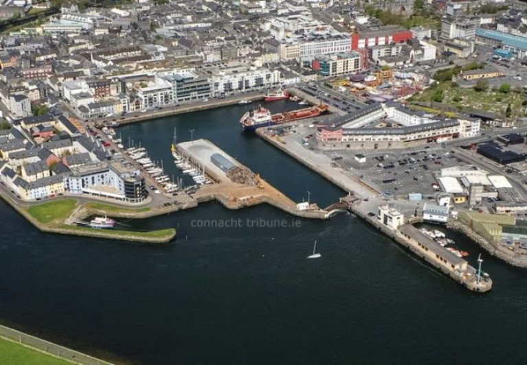
Inclusion of the Port of Galway in Major EU Transport Funding Programme
On the west coast, the Port of Galway has been included in a major EU transport funding programme.
The port comprising of the Dún Aengus Dock basin, has been included in the programme following an agreement reached by the EU Transport Council as part of the European TEN-T network.
The inclusion of the Port Galway is a first for the harbour located close to the city's centre.
As Galway Bay FM reports, the TEN-T network supports transport infrastructure projects, including ports, road, rail and inland waterways.
Galway Port's CEO Conor O’ Dowd when speaking to Galway Talks, had said this is a major step forward for the West of Ireland.
The CEO added that he is hopeful that the planned redevelopment of the Port will get the green light next year.
To listen more from the CEO, click the link to the radio station for a podcast..
Irish Rail (Iarnród Eireann) has announced the purchase of an 18-acre site in Rosslare Europort to support the future growth of the (ferry)harbour which has seen a significant increase in traffic and new routes.
The company also revealed that it has awarded the contract for a new fully-digital Port Terminal Management System.
The developments are part of the overall Rosslare Europort Masterplan designed to enhance port operations and customer experience.
Agreement has been reached to secure a strategic 18 acres of land on an adjacent site that is zoned for commercial use, beside the proposed new port freight entrance.
The site will have direct connection to both the port and the new port access road being constructed by Transport Infrastructure Ireland and Wexford County Council.
Wexford People has more on the development.
Also this week Irish Rail was awarded €2.5 million from EU funding into projects to improve transport links including by road with the port.
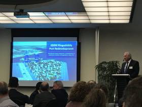
An increase in EU funding for Galway Port has been pushed for following a series of meetings in Brussels this week.
The meetings, facilitated by MEP for this region Colm Markey, took place between port representatives, officials from the European Commission and a number of MEPS.
The focus was on potential funding streams for the planned redevelopment of Galway Port, with a focus on supporting offshore wind capacity.
Advocates say the North-West has the best wind speeds in Europe, but it is the only maritime region not included in the Trans European Transport Network.
Connacht Tribune also has a podcast from the port's CEO and the role of TEN-T.
#Ports&Shipping - At significant risk of isolation will be Ireland following Brexit and this will need EU funding to shore up the lack of connectivity to major European routes says the Port of Cork chief executive.
As the Irish Examiner writes, Brendan Keating says there was a case to be made for grant aid from EU institutions following the UK leaving the bloc.
“We will be significantly more isolated because of Brexit. I’m concerned about maritime transport connectivity. State aid rules as currently constituted don’t allow EU support of the purchase of ships or that kind of mobile asset, I believe.
“However, I do believe some kind of subvention can be issued to operators of such ships for such services.
“We have similar arrangements in terms of the servicing of regional airports of this country, to the public service obligations-type instruments.
For further comments and developments for the Port of Cork click here.


