Menu

Ireland's sailing, boating & maritime magazine

Dublin Bay Boating News and Information

Displaying items by tag: Eurofleets

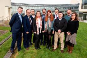
#MarineScience - The EurofleetPlus Kick-off meeting held at the Marine Institute in Galway this past week (Tuesday 5 to Thursday 7 March) announced details of the project that will facilitate access to the largest advanced marine science research vessel fleet across Europe, Greenland, USA and Canada, Bermuda and New Zealand.

Building on the achievements of the two preceding Eurofleets projects, the Marine Institute is a co-ordinator of EurofleetsPlus, a consortium comprising 42 marine institutes, universities, foundations and SMEs from 24 countries across Europe, North America and Oceania, with funding of €9.9 million.

Welcoming Ireland’s leadership role in this major EU Horizon 2020-funded project, Marine Minister Michael Creed said: “This recognises the high standards of scientific and operational excellence which continue to be achieved by the Marine Institute and is particularly relevant in the strategically important arena of research vessels operations, where the Marine Institute’s RV Celtic Explorer operates over 300 days of the year.

“Ireland’s participation in international research partnerships such as EurofleetsPlus adds value to Ireland’s ocean research capacity and I congratulate the Marine Institute on its outstanding success rate of 40% in Horizon 2020 funding bids totalling €6.6 million since 2014.”

Involving trans-national activities, the project will prioritise research on sustainable, clean and healthy oceans, linking with existing ocean observation infrastructures, as well as support innovative ideas working closely with industry.

Aodhán Fitzgerald, RV operations manager at the Marine Institute and EurofleetsPlus project co-ordinator, said that the project will enable access to an unprecedented number of vessels providing a significant increase in ship time at sea.

“With a fleet of 27 state-of-the-art research vessels from European and other international partners, this is extremely exciting for marine researchers as they now have opportunities to access research vessels in the North Atlantic, Mediterranean, Black Sea, North Sea, Baltic Sea, Pacific Southern Ocean and Ross Sea, through the competitive calls process.”

In addition to ship time, marine researchers and scientists will also have the opportunity to work with the best marine equipment and marine infrastructure exploring the ocean in ways that have not been possible in the past.

This will include access to seven new remotely operated vehicles (ROVs) to capture video and samples from the deepest parts of the ocean. The researchers will have access to five autonomous underwater vehicles for collecting data relating to the ocean environment.

In addition, a unique mobile portable telepresence unit will also enable remote access by researchers and diverse end users including the public, which is a first for Europe.

Establishing a strategic roadmap and sustainability plan, EurofleetsPlus will extend and enhance the capabilities of the European research vessel infrastructure, bringing new perspectives, new ideas, and new research and innovation tracks that will be beneficial to all.

At the kick-off meeting, Fitzgerald added: “I am looking forward to working with established and new partners over the next four years. This trans-national project will provide us all with a unique opportunity to develop our networking activities, ensure robust call processes with booking ship-time, as well as increase our stakeholder engagement at a national and international level.”

EurofleetsPlus is funded under Horizon 2020 Integrating Activity for Advanced Communities with respect to Environmental and Earth Sciences - Research Vessels. The project has received funding from the European Union's Horizon 2020 research and innovation programme under grant agreement No 824077.

Published in Marine Science

Imagine being able to plan, design and carry out your own scientific survey into the seas around us. Last week research students from across Europe were given just such an opportunity when they joined scientists onboard the Irish national research vessel RV Celtic Voyager in waters off Cork.

This unique opportunity for students to gain practical experience in carrying out multidisciplinary marine scientific research is part of the European Framework 7 project EUROFLEETS, and was designed, developed and co-funded by the Marine Institute, Ireland.

Over the course of six days, between the 14th and 19th August, 20 European postgraduate students learned the skills necessary to map the seabed, identify the animals and plants living there, and investigate the local and oceanic currents that influence them. Training focused specifically on operational research and included the deployment of equipment and instrumentation, sample recovery and processing, and data acquisition. Other modules investigated designing and planning a survey, operations and capabilities of research vessels and safety at sea.

Published in Marine Science

Dublin Bay

Dublin Bay on the east coast of Ireland stretches over seven kilometres, from Howth Head on its northern tip to Dalkey Island in the south. It's a place most Dubliners simply take for granted, and one of the capital's least visited places. But there's more going on out there than you'd imagine.

The biggest boating centre is at Dun Laoghaire Harbour on the Bay's south shore that is home to over 1,500 pleasure craft, four waterfront yacht clubs and Ireland's largest marina.

The bay is rather shallow with many sandbanks and rocky outcrops, and was notorious in the past for shipwrecks, especially when the wind was from the east. Until modern times, many ships and their passengers were lost along the treacherous coastline from Howth to Dun Laoghaire, less than a kilometre from shore.

The Bay is a C-shaped inlet of the Irish Sea and is about 10 kilometres wide along its north-south base, and 7 km in length to its apex at the centre of the city of Dublin; stretching from Howth Head in the north to Dalkey Point in the south. North Bull Island is situated in the northwest part of the bay, where one of two major inshore sandbanks lie, and features a 5 km long sandy beach, Dollymount Strand, fronting an internationally recognised wildfowl reserve. Many of the rivers of Dublin reach the Irish Sea at Dublin Bay: the River Liffey, with the River Dodder flow received less than 1 km inland, River Tolka, and various smaller rivers and streams.

Dublin Bay FAQs

There are approximately ten beaches and bathing spots around Dublin Bay: Dollymount Strand; Forty Foot Bathing Place; Half Moon bathing spot; Merrion Strand; Bull Wall; Sandycove Beach; Sandymount Strand; Seapoint; Shelley Banks; Sutton, Burrow Beach

There are slipways on the north side of Dublin Bay at Clontarf, Sutton and on the southside at Dun Laoghaire Harbour, and in Dalkey at Coliemore and Bulloch Harbours.

Dublin Bay is administered by a number of Government Departments, three local authorities and several statutory agencies. Dublin Port Company is in charge of navigation on the Bay.

Dublin Bay is approximately 70 sq kilometres or 7,000 hectares. The Bay is about 10 kilometres wide along its north-south base, and seven km in length east-west to its peak at the centre of the city of Dublin; stretching from Howth Head in the north to Dalkey Point in the south.

Dun Laoghaire Harbour on the southside of the Bay has an East and West Pier, each one kilometre long; this is one of the largest human-made harbours in the world. There also piers or walls at the entrance to the River Liffey at Dublin city known as the Great North and South Walls. Other harbours on the Bay include Bulloch Harbour and Coliemore Harbours both at Dalkey.

There are two marinas on Dublin Bay. Ireland's largest marina with over 800 berths is on the southern shore at Dun Laoghaire Harbour. The other is at Poolbeg Yacht and Boat Club on the River Liffey close to Dublin City.

Car and passenger Ferries operate from Dublin Port to the UK, Isle of Man and France. A passenger ferry operates from Dun Laoghaire Harbour to Howth as well as providing tourist voyages around the bay.

Dublin Bay has two Islands. Bull Island at Clontarf and Dalkey Island on the southern shore of the Bay.

The River Liffey flows through Dublin city and into the Bay. Its tributaries include the River Dodder, the River Poddle and the River Camac.

Dollymount, Burrow and Seapoint beaches

Approximately 1,500 boats from small dinghies to motorboats to ocean-going yachts. The vast majority, over 1,000, are moored at Dun Laoghaire Harbour which is Ireland's boating capital.

In 1981, UNESCO recognised the importance of Dublin Bay by designating North Bull Island as a Biosphere because of its rare and internationally important habitats and species of wildlife. To support sustainable development, UNESCO’s concept of a Biosphere has evolved to include not just areas of ecological value but also the areas around them and the communities that live and work within these areas. There have since been additional international and national designations, covering much of Dublin Bay, to ensure the protection of its water quality and biodiversity. To fulfil these broader management aims for the ecosystem, the Biosphere was expanded in 2015. The Biosphere now covers Dublin Bay, reflecting its significant environmental, economic, cultural and tourism importance, and extends to over 300km² to include the bay, the shore and nearby residential areas.

On the Southside at Dun Laoghaire, there is the National Yacht Club, Royal St. George Yacht Club, Royal Irish Yacht Club and Dun Laoghaire Motor Yacht Club as well as Dublin Bay Sailing Club. In the city centre, there is Poolbeg Yacht and Boat Club. On the Northside of Dublin, there is Clontarf Yacht and Boat Club and Sutton Dinghy Club. While not on Dublin Bay, Howth Yacht Club is the major north Dublin Sailing centre.

© Afloat 2020