Menu

Ireland's sailing, boating & maritime magazine

Dublin Bay Boating News and Information

Displaying items by tag: Final Farewell Voyage

#Ports&Shipping - RMS St.Helena, the last ship from a mighty fleet that once bound Britain’s scattered empire together will arrive today (Monday, 29 January) after its final voyage to St Helena.

As the UK newspaper, The Times reports the isolated British overseas island territory in the Atlantic Ocean that for hundreds of years was accessible only by sea.

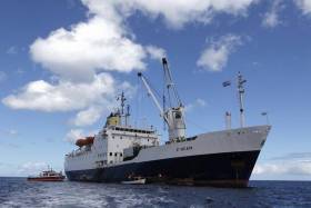
RMS St Helena, one of only two ocean-going vessels that still bear the title “Royal Mail Ship”, will end a final five-day journey from Cape Town, South Africa (haven departed last Wednesday) The unique occasion has been marked by pipe bands, ceremonies and an outpouring of nostalgia.

A flotilla of small boats, the British governor and a huge crowd will greet the ship as she anchors in the bay off Jamestown, the capital.

There will be parties aboard and tours of the ship that for 27 years was the island’s only…to read more click here. Note registration is required to continue further reading of the story.

Afloat.ie can update to confirm according to AIS tracking, that the St. Helena Line passenger-cargsoship is currently at anchorage offshore of the remote island. Next month the only scheduled sea connection will be served exclusively by a cargo-only containership.

During a reception held on board the RMS St. Helena's final (and only) farewell visit to London in 2016, the topic of the ship's replacement was discussed with Afloat from representatives of AW Ship Management. It was disclosed then that a German containership would be taken under contract to continue St. Helena operations based out of Cape Town and also maintain serving Ascension Island. The ship in question is the former Eemslift Christian, renamed Helena which is to begin the new cargo-only service. More on this to appear on Ports & Shipping news. 

As for the Islanders or 'Saints' as they call themselves and tourists alike, they have since October last year had the option of taking commercial flights to and from South Africa to the island's first ever airport. The facility caused much controversary given delays arising from safety concerns of aircraft using the runway but were finally resolved. The airport is a game-changer in terms of tourism opportunities and developing new business links. 

Among a programme of events to mark the historic farewell voyage on St. Helena, according to the island Government's website will start next week on Tuesday, 6 February, with a Thanksgiving Service at St James’ Church. The service starts at 7pm and all are invited to attend. Following the service the RMS crew will proceed to the Seafront for a Blessing. 

A special RMS Open Day will be held on Friday, 9 February, which will allow the Saints a final opportunity to view the ship based on those who have already made a booking. The public viewing will permit access to the bridge overlooking the cargodeck, the passenger facilities and several cabins. Invariably this will prove to be an emotional day. 

Celebrations on the Seafront will start at 3pm and will include a local market, RMS entertainment, an exciting performance by the RMS Amateur Dramatics Society and live music by various local bands. Festivities will continue until midnight.

The RMS St. Helena will depart for the very last time when a final voyage from St. Helena is on Saturday, 10 February and returning to the South African port. This will truly be an end of era not just for the Saints but as part of world maritime history. 

Published in Ports & Shipping

#Ports&Shipping - RMS St Helena, a UK flagged Royal Mail Ship as previously reported on Afloat, that was once a lifeline to the outside world for St Helena is making its last voyage to the remote South Atlantic island where Napoleon died in exile.

According to Gazette News, RMS St Helena’s route for the last three decades is being phased out because a South African airline started a weekly commercial flight in October after the delayed opening of an airport on the volcanic island, and flights could become more frequent if there is demand.

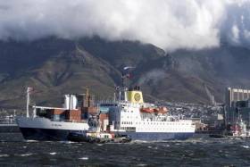
Until last year, the “royal mail” vessel had been the only regular way to reach British-ruled St Helena for passengers who spent nearly a week at sea after departure from the South African city of Cape Town.

Ahead of the ship’s final departure from Cape Town on Wednesday, diplomats, tourism officials and crew members mingled at an on-board reception.

To read more of this historic farewell unique passenger-cargo voyage and photos click here. 

Published in Ports & Shipping

Dublin Bay

Dublin Bay on the east coast of Ireland stretches over seven kilometres, from Howth Head on its northern tip to Dalkey Island in the south. It's a place most Dubliners simply take for granted, and one of the capital's least visited places. But there's more going on out there than you'd imagine.

The biggest boating centre is at Dun Laoghaire Harbour on the Bay's south shore that is home to over 1,500 pleasure craft, four waterfront yacht clubs and Ireland's largest marina.

The bay is rather shallow with many sandbanks and rocky outcrops, and was notorious in the past for shipwrecks, especially when the wind was from the east. Until modern times, many ships and their passengers were lost along the treacherous coastline from Howth to Dun Laoghaire, less than a kilometre from shore.

The Bay is a C-shaped inlet of the Irish Sea and is about 10 kilometres wide along its north-south base, and 7 km in length to its apex at the centre of the city of Dublin; stretching from Howth Head in the north to Dalkey Point in the south. North Bull Island is situated in the northwest part of the bay, where one of two major inshore sandbanks lie, and features a 5 km long sandy beach, Dollymount Strand, fronting an internationally recognised wildfowl reserve. Many of the rivers of Dublin reach the Irish Sea at Dublin Bay: the River Liffey, with the River Dodder flow received less than 1 km inland, River Tolka, and various smaller rivers and streams.

Dublin Bay FAQs

There are approximately ten beaches and bathing spots around Dublin Bay: Dollymount Strand; Forty Foot Bathing Place; Half Moon bathing spot; Merrion Strand; Bull Wall; Sandycove Beach; Sandymount Strand; Seapoint; Shelley Banks; Sutton, Burrow Beach

There are slipways on the north side of Dublin Bay at Clontarf, Sutton and on the southside at Dun Laoghaire Harbour, and in Dalkey at Coliemore and Bulloch Harbours.

Dublin Bay is administered by a number of Government Departments, three local authorities and several statutory agencies. Dublin Port Company is in charge of navigation on the Bay.

Dublin Bay is approximately 70 sq kilometres or 7,000 hectares. The Bay is about 10 kilometres wide along its north-south base, and seven km in length east-west to its peak at the centre of the city of Dublin; stretching from Howth Head in the north to Dalkey Point in the south.

Dun Laoghaire Harbour on the southside of the Bay has an East and West Pier, each one kilometre long; this is one of the largest human-made harbours in the world. There also piers or walls at the entrance to the River Liffey at Dublin city known as the Great North and South Walls. Other harbours on the Bay include Bulloch Harbour and Coliemore Harbours both at Dalkey.

There are two marinas on Dublin Bay. Ireland's largest marina with over 800 berths is on the southern shore at Dun Laoghaire Harbour. The other is at Poolbeg Yacht and Boat Club on the River Liffey close to Dublin City.

Car and passenger Ferries operate from Dublin Port to the UK, Isle of Man and France. A passenger ferry operates from Dun Laoghaire Harbour to Howth as well as providing tourist voyages around the bay.

Dublin Bay has two Islands. Bull Island at Clontarf and Dalkey Island on the southern shore of the Bay.

The River Liffey flows through Dublin city and into the Bay. Its tributaries include the River Dodder, the River Poddle and the River Camac.

Dollymount, Burrow and Seapoint beaches

Approximately 1,500 boats from small dinghies to motorboats to ocean-going yachts. The vast majority, over 1,000, are moored at Dun Laoghaire Harbour which is Ireland's boating capital.

In 1981, UNESCO recognised the importance of Dublin Bay by designating North Bull Island as a Biosphere because of its rare and internationally important habitats and species of wildlife. To support sustainable development, UNESCO’s concept of a Biosphere has evolved to include not just areas of ecological value but also the areas around them and the communities that live and work within these areas. There have since been additional international and national designations, covering much of Dublin Bay, to ensure the protection of its water quality and biodiversity. To fulfil these broader management aims for the ecosystem, the Biosphere was expanded in 2015. The Biosphere now covers Dublin Bay, reflecting its significant environmental, economic, cultural and tourism importance, and extends to over 300km² to include the bay, the shore and nearby residential areas.

On the Southside at Dun Laoghaire, there is the National Yacht Club, Royal St. George Yacht Club, Royal Irish Yacht Club and Dun Laoghaire Motor Yacht Club as well as Dublin Bay Sailing Club. In the city centre, there is Poolbeg Yacht and Boat Club. On the Northside of Dublin, there is Clontarf Yacht and Boat Club and Sutton Dinghy Club. While not on Dublin Bay, Howth Yacht Club is the major north Dublin Sailing centre.

© Afloat 2020