Menu

Ireland's sailing, boating & maritime magazine

Dublin Bay Boating News and Information

Displaying items by tag: First cruiseship of 2017

#CruiseFirst - A pair of Fred Olsen Lines sisters marked both the last cruise call to Dublin Port in 2016 and as the first of the New Year, writes Jehan Ashmore.

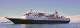
The conservative yet handsome profile of Boudicca sailed into Dublin at dawn. The 880 passenger cruiseship had sailed from the opposite side of the Irish Sea having cast off mooring ropes from Liverpool’s famous waterfront. The ship had berthed at the cruise terminal located near the landmark buildings known as the ‘Three Graces’.

On boards are cruise-goers taking in the early New Year sights and visiting tourist attractions of Dublin's 'Fair City' before Boudicca sets sail this evening at 18.00hrs. The next port of call been Southampton. Likewise of the Irish capital, the Hampshire port is the UK’s busiest for cruiseships along with trading in general cargo, notably through giant ocean-going containerships.

Within the last fortnight sister, Black Watch had too disembarked tourists to visit Dublin which in 2016 the port welcomed 112 cruiseships.

The veteran vessels of 28,000 gross tonnage each and dating to the 1970’s belong to an increasing rare breed of first generation cruiseships. With the passing of more than four decades they have become by default yet even more pleasing to the aesthestic eye.

In comparison to some of the behemoths of modern day cruiseships and newbuilds that will descend into the Dublin Port of the future using a new cruise €30m terminal granted planning permission.

The facility a first for the port is part of the Alexandra Basin Redevelopment (ABR) Project. This is phase one of the Masterplan for the port up to 2040.

Currently the vast majority of cruiseships dock in Alexandra Basin (west and east). It is in the east basin, the larger of the two where Boudicca of 206m in length is berthed alongside Ocean Pier. This is also where larger cruiseships of 300m in length dock while considerably smaller ships can head downriver close to the city quays.

Port access issues such as restrictions on overall cruiseship dimensions will be resolved by an extensive dredging programme within the port but also the approach channels off Poolbeg Lighthouse.

This will enable the largest cruiseships in the world to dock following realignment of quays within Alexandra Basin. Such works will permit  these massive cruiseships up to 340m in length to swing around the increased turning circle inside the basin. 

Published in Cruise Liners

Dublin Bay

Dublin Bay on the east coast of Ireland stretches over seven kilometres, from Howth Head on its northern tip to Dalkey Island in the south. It's a place most Dubliners simply take for granted, and one of the capital's least visited places. But there's more going on out there than you'd imagine.

The biggest boating centre is at Dun Laoghaire Harbour on the Bay's south shore that is home to over 1,500 pleasure craft, four waterfront yacht clubs and Ireland's largest marina.

The bay is rather shallow with many sandbanks and rocky outcrops, and was notorious in the past for shipwrecks, especially when the wind was from the east. Until modern times, many ships and their passengers were lost along the treacherous coastline from Howth to Dun Laoghaire, less than a kilometre from shore.

The Bay is a C-shaped inlet of the Irish Sea and is about 10 kilometres wide along its north-south base, and 7 km in length to its apex at the centre of the city of Dublin; stretching from Howth Head in the north to Dalkey Point in the south. North Bull Island is situated in the northwest part of the bay, where one of two major inshore sandbanks lie, and features a 5 km long sandy beach, Dollymount Strand, fronting an internationally recognised wildfowl reserve. Many of the rivers of Dublin reach the Irish Sea at Dublin Bay: the River Liffey, with the River Dodder flow received less than 1 km inland, River Tolka, and various smaller rivers and streams.

Dublin Bay FAQs

There are approximately ten beaches and bathing spots around Dublin Bay: Dollymount Strand; Forty Foot Bathing Place; Half Moon bathing spot; Merrion Strand; Bull Wall; Sandycove Beach; Sandymount Strand; Seapoint; Shelley Banks; Sutton, Burrow Beach

There are slipways on the north side of Dublin Bay at Clontarf, Sutton and on the southside at Dun Laoghaire Harbour, and in Dalkey at Coliemore and Bulloch Harbours.

Dublin Bay is administered by a number of Government Departments, three local authorities and several statutory agencies. Dublin Port Company is in charge of navigation on the Bay.

Dublin Bay is approximately 70 sq kilometres or 7,000 hectares. The Bay is about 10 kilometres wide along its north-south base, and seven km in length east-west to its peak at the centre of the city of Dublin; stretching from Howth Head in the north to Dalkey Point in the south.

Dun Laoghaire Harbour on the southside of the Bay has an East and West Pier, each one kilometre long; this is one of the largest human-made harbours in the world. There also piers or walls at the entrance to the River Liffey at Dublin city known as the Great North and South Walls. Other harbours on the Bay include Bulloch Harbour and Coliemore Harbours both at Dalkey.

There are two marinas on Dublin Bay. Ireland's largest marina with over 800 berths is on the southern shore at Dun Laoghaire Harbour. The other is at Poolbeg Yacht and Boat Club on the River Liffey close to Dublin City.

Car and passenger Ferries operate from Dublin Port to the UK, Isle of Man and France. A passenger ferry operates from Dun Laoghaire Harbour to Howth as well as providing tourist voyages around the bay.

Dublin Bay has two Islands. Bull Island at Clontarf and Dalkey Island on the southern shore of the Bay.

The River Liffey flows through Dublin city and into the Bay. Its tributaries include the River Dodder, the River Poddle and the River Camac.

Dollymount, Burrow and Seapoint beaches

Approximately 1,500 boats from small dinghies to motorboats to ocean-going yachts. The vast majority, over 1,000, are moored at Dun Laoghaire Harbour which is Ireland's boating capital.

In 1981, UNESCO recognised the importance of Dublin Bay by designating North Bull Island as a Biosphere because of its rare and internationally important habitats and species of wildlife. To support sustainable development, UNESCO’s concept of a Biosphere has evolved to include not just areas of ecological value but also the areas around them and the communities that live and work within these areas. There have since been additional international and national designations, covering much of Dublin Bay, to ensure the protection of its water quality and biodiversity. To fulfil these broader management aims for the ecosystem, the Biosphere was expanded in 2015. The Biosphere now covers Dublin Bay, reflecting its significant environmental, economic, cultural and tourism importance, and extends to over 300km² to include the bay, the shore and nearby residential areas.

On the Southside at Dun Laoghaire, there is the National Yacht Club, Royal St. George Yacht Club, Royal Irish Yacht Club and Dun Laoghaire Motor Yacht Club as well as Dublin Bay Sailing Club. In the city centre, there is Poolbeg Yacht and Boat Club. On the Northside of Dublin, there is Clontarf Yacht and Boat Club and Sutton Dinghy Club. While not on Dublin Bay, Howth Yacht Club is the major north Dublin Sailing centre.

© Afloat 2020