Menu

Ireland's sailing, boating & maritime magazine

Dublin Bay Boating News and Information

Displaying items by tag: Five Decades of Operations

#TheTyrrells – Fifty years ago Arklow Shipping was formed, following the amalgamation in 1966 of three independent shipowning families from the east coast port in Co. Wicklow, writes Jehan Ashmore.

The families, Tyrrell, Kearon and the Hall’s all had origins directly in trading auxiliary sailing schooners from the banks of the River Avoca that flows through Arklow into the Irish Sea. The era of the days of sail trading were coming to a close during the 1950’s and ‘60’s as motorised coasters were increasingly taking over from the traditional schooners of the single-ship owners.

It was felt in certain quarters that such practises needed to be overhauled so to compete. This led to a co-operative which removed inefficiencies of the independent shipowners and instead by pooling resources to reduce costs.

The decline of the schooners by more efficient coasters led to the last Irish Sea schooner, De Wadden disposed. The vessel remains on display at the Merseyside Maritime Museum, Liverpool.

In the earliest formation to pool resources, the Arklow shipowners acquired a 12 year old German ship. The vessel had been taken as a war prize in 1945 by the British Admiralty and was sold in 1947 to trade with the Arklow families and renamed Tyrronall.

The coaster, Tyrronell derived its name from three letters chosen from the family surnames. The co-operative progressed when in 1966, Captains James Tyrrell, Michael Tyrrell and Victor Hall formed an umbrella company, Arklow Shipping under which together operated seven ships.

Under the following ship-owners: James Tyrrell Ltd contributed vessels (Darell, Valzell, Mariezell and Murell), Captain Michael Tyrrell (Avondale), Captain Richard Hall (River Avoca) and George Kearon Ltd (Reginald Kearon and Gloria). Of this initial fleet, all but two were managed by ASL.

It was not until 1970 that officially the company, Arklow Shipping Ltd was formed and over the next five decades, ASL have acquired numerous second-hand tonnage and ordered series of custom built vessels, notably from yards in the Netherlands, Spain and Korea.

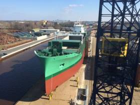
The vessel naming nomenclature is now based on a nominated letter. i.e. the latest  is 'V' for the recent newbuild series, in which Arklow Valiant was launched last month. This vessel is the third of 10 newbuild 5,100dwat tonnes general cargsoships completed by Dutch yard, Royal Bodewes.

Asides the newbuild, the fleet total is 45-strong and ships are either general dry-cargo traders or bulk-carriers. The smallest series in the fleet are the 'R' class, for example, Arklow Rose of 4,933dwt to the largest 'S' class bulkers, the Arklow Spray of 34,905dwt. Both vessels are Irish flagged and unlike the newbuilds will be Dutch flagged under Arklow Shipping Nederland B.V. 

Across the ASL fleet, they transport a variety of cargoes among them in the bulk grain trades, steel rails, minerals, generals and containers.

The trading area is mostly north-western Europe though the bulk-carriers operate on international deep-sea trade routes.

Published in Arklow Shipping

Dublin Bay

Dublin Bay on the east coast of Ireland stretches over seven kilometres, from Howth Head on its northern tip to Dalkey Island in the south. It's a place most Dubliners simply take for granted, and one of the capital's least visited places. But there's more going on out there than you'd imagine.

The biggest boating centre is at Dun Laoghaire Harbour on the Bay's south shore that is home to over 1,500 pleasure craft, four waterfront yacht clubs and Ireland's largest marina.

The bay is rather shallow with many sandbanks and rocky outcrops, and was notorious in the past for shipwrecks, especially when the wind was from the east. Until modern times, many ships and their passengers were lost along the treacherous coastline from Howth to Dun Laoghaire, less than a kilometre from shore.

The Bay is a C-shaped inlet of the Irish Sea and is about 10 kilometres wide along its north-south base, and 7 km in length to its apex at the centre of the city of Dublin; stretching from Howth Head in the north to Dalkey Point in the south. North Bull Island is situated in the northwest part of the bay, where one of two major inshore sandbanks lie, and features a 5 km long sandy beach, Dollymount Strand, fronting an internationally recognised wildfowl reserve. Many of the rivers of Dublin reach the Irish Sea at Dublin Bay: the River Liffey, with the River Dodder flow received less than 1 km inland, River Tolka, and various smaller rivers and streams.

Dublin Bay FAQs

There are approximately ten beaches and bathing spots around Dublin Bay: Dollymount Strand; Forty Foot Bathing Place; Half Moon bathing spot; Merrion Strand; Bull Wall; Sandycove Beach; Sandymount Strand; Seapoint; Shelley Banks; Sutton, Burrow Beach

There are slipways on the north side of Dublin Bay at Clontarf, Sutton and on the southside at Dun Laoghaire Harbour, and in Dalkey at Coliemore and Bulloch Harbours.

Dublin Bay is administered by a number of Government Departments, three local authorities and several statutory agencies. Dublin Port Company is in charge of navigation on the Bay.

Dublin Bay is approximately 70 sq kilometres or 7,000 hectares. The Bay is about 10 kilometres wide along its north-south base, and seven km in length east-west to its peak at the centre of the city of Dublin; stretching from Howth Head in the north to Dalkey Point in the south.

Dun Laoghaire Harbour on the southside of the Bay has an East and West Pier, each one kilometre long; this is one of the largest human-made harbours in the world. There also piers or walls at the entrance to the River Liffey at Dublin city known as the Great North and South Walls. Other harbours on the Bay include Bulloch Harbour and Coliemore Harbours both at Dalkey.

There are two marinas on Dublin Bay. Ireland's largest marina with over 800 berths is on the southern shore at Dun Laoghaire Harbour. The other is at Poolbeg Yacht and Boat Club on the River Liffey close to Dublin City.

Car and passenger Ferries operate from Dublin Port to the UK, Isle of Man and France. A passenger ferry operates from Dun Laoghaire Harbour to Howth as well as providing tourist voyages around the bay.

Dublin Bay has two Islands. Bull Island at Clontarf and Dalkey Island on the southern shore of the Bay.

The River Liffey flows through Dublin city and into the Bay. Its tributaries include the River Dodder, the River Poddle and the River Camac.

Dollymount, Burrow and Seapoint beaches

Approximately 1,500 boats from small dinghies to motorboats to ocean-going yachts. The vast majority, over 1,000, are moored at Dun Laoghaire Harbour which is Ireland's boating capital.

In 1981, UNESCO recognised the importance of Dublin Bay by designating North Bull Island as a Biosphere because of its rare and internationally important habitats and species of wildlife. To support sustainable development, UNESCO’s concept of a Biosphere has evolved to include not just areas of ecological value but also the areas around them and the communities that live and work within these areas. There have since been additional international and national designations, covering much of Dublin Bay, to ensure the protection of its water quality and biodiversity. To fulfil these broader management aims for the ecosystem, the Biosphere was expanded in 2015. The Biosphere now covers Dublin Bay, reflecting its significant environmental, economic, cultural and tourism importance, and extends to over 300km² to include the bay, the shore and nearby residential areas.

On the Southside at Dun Laoghaire, there is the National Yacht Club, Royal St. George Yacht Club, Royal Irish Yacht Club and Dun Laoghaire Motor Yacht Club as well as Dublin Bay Sailing Club. In the city centre, there is Poolbeg Yacht and Boat Club. On the Northside of Dublin, there is Clontarf Yacht and Boat Club and Sutton Dinghy Club. While not on Dublin Bay, Howth Yacht Club is the major north Dublin Sailing centre.

© Afloat 2020