Menu

Ireland's sailing, boating & maritime magazine

Dublin Bay Boating News and Information

Displaying items by tag: Handle Trade of

The ferryport of Rosslare Europort will undergo a €30m transformation over the next five years and is the ideal port to alleviate traffic congestion and lessen pollution in Dublin, according to manager Glenn Carr.

As the New Ross Standard reports, Mr Carr said there are 100 acres of land waiting to be developed within a five kilometre radius of the port, an unrivalled landbank in the country, adding that it makes perfect sense for Dublin Port ships and shipping activity to be moved to Rosslare. Planning permission to develop a new access road and entrance has been submitted, with works due to commence this winter - and combined with major plans by the OPW to develop a customs unit at the port - Rosslare Europort is able to take over 20 per cent of activity from Dublin in the coming years.

Mr Carr said: 'Both outside Dublin Port on the M50 and inside, there is congestion. The current situation is not the norm. The norm prior to Covid saw lorries delayed outside the port and even in the port tunnel. With Brexit approaching we do believe that Rosslare has a very strong role to play as geographically it is the closest port to mainland Europe. Companies can save seven hours, (three and a half hours each way) on the Irish Sea on direct services going to Europe.'

He said the Enniscorthy Bypass has saved hauliers 25 minutes on their journey, adding that the opening of the New Ross Bypass has also strengthened the case for the port. For hauliers travelling to distribution centres along the outer M50 in Dublin, Rosslare is now a lot easier to get to. 'The time you would lose on the ship, you'd gain on the road. The New Ross Bypass provides improved connectivity to Cork, Waterford and Limerick, which are main arteries that a lot of product is moved to. We have seen that with the new Brittany Ferries [Bilbao] service, which moved here from Cork. The biggest factor [behind the move] was that the industry wanted the route in Rosslare because it was easier and quicker to get to so there is already evidence that Rosslare is a real alternative to Dublin.

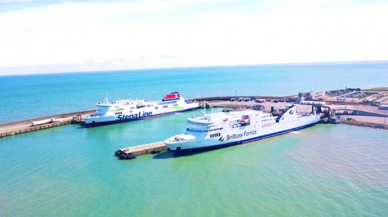
Presently around 84 per cent of roll-on, roll-off shipping activity occurs in Dublin Port, the remaining 16 per cent falling to Rosslare.

For Carr, there is no other port in Ireland better suited to roll-on, roll-off. because of the better access in and out of the port.

For much more on this ferry development click here.

Afloat adds Brittany Ferries were to have launched a second new route out of Rosslare to Roscoff, but due to Covid-19 the start date has been rescheduled to this month. The inaugural sailing is in a fortnight's time, Monday 15th June.

In the meantime Kerry maintains the year-round Spanish service albeit in a freight-only mode until sailings open to passengers return on Wednesday 17th June.

Published in Rosslare Europort

Dublin Bay

Dublin Bay on the east coast of Ireland stretches over seven kilometres, from Howth Head on its northern tip to Dalkey Island in the south. It's a place most Dubliners simply take for granted, and one of the capital's least visited places. But there's more going on out there than you'd imagine.

The biggest boating centre is at Dun Laoghaire Harbour on the Bay's south shore that is home to over 1,500 pleasure craft, four waterfront yacht clubs and Ireland's largest marina.

The bay is rather shallow with many sandbanks and rocky outcrops, and was notorious in the past for shipwrecks, especially when the wind was from the east. Until modern times, many ships and their passengers were lost along the treacherous coastline from Howth to Dun Laoghaire, less than a kilometre from shore.

The Bay is a C-shaped inlet of the Irish Sea and is about 10 kilometres wide along its north-south base, and 7 km in length to its apex at the centre of the city of Dublin; stretching from Howth Head in the north to Dalkey Point in the south. North Bull Island is situated in the northwest part of the bay, where one of two major inshore sandbanks lie, and features a 5 km long sandy beach, Dollymount Strand, fronting an internationally recognised wildfowl reserve. Many of the rivers of Dublin reach the Irish Sea at Dublin Bay: the River Liffey, with the River Dodder flow received less than 1 km inland, River Tolka, and various smaller rivers and streams.

Dublin Bay FAQs

There are approximately ten beaches and bathing spots around Dublin Bay: Dollymount Strand; Forty Foot Bathing Place; Half Moon bathing spot; Merrion Strand; Bull Wall; Sandycove Beach; Sandymount Strand; Seapoint; Shelley Banks; Sutton, Burrow Beach

There are slipways on the north side of Dublin Bay at Clontarf, Sutton and on the southside at Dun Laoghaire Harbour, and in Dalkey at Coliemore and Bulloch Harbours.

Dublin Bay is administered by a number of Government Departments, three local authorities and several statutory agencies. Dublin Port Company is in charge of navigation on the Bay.

Dublin Bay is approximately 70 sq kilometres or 7,000 hectares. The Bay is about 10 kilometres wide along its north-south base, and seven km in length east-west to its peak at the centre of the city of Dublin; stretching from Howth Head in the north to Dalkey Point in the south.

Dun Laoghaire Harbour on the southside of the Bay has an East and West Pier, each one kilometre long; this is one of the largest human-made harbours in the world. There also piers or walls at the entrance to the River Liffey at Dublin city known as the Great North and South Walls. Other harbours on the Bay include Bulloch Harbour and Coliemore Harbours both at Dalkey.

There are two marinas on Dublin Bay. Ireland's largest marina with over 800 berths is on the southern shore at Dun Laoghaire Harbour. The other is at Poolbeg Yacht and Boat Club on the River Liffey close to Dublin City.

Car and passenger Ferries operate from Dublin Port to the UK, Isle of Man and France. A passenger ferry operates from Dun Laoghaire Harbour to Howth as well as providing tourist voyages around the bay.

Dublin Bay has two Islands. Bull Island at Clontarf and Dalkey Island on the southern shore of the Bay.

The River Liffey flows through Dublin city and into the Bay. Its tributaries include the River Dodder, the River Poddle and the River Camac.

Dollymount, Burrow and Seapoint beaches

Approximately 1,500 boats from small dinghies to motorboats to ocean-going yachts. The vast majority, over 1,000, are moored at Dun Laoghaire Harbour which is Ireland's boating capital.

In 1981, UNESCO recognised the importance of Dublin Bay by designating North Bull Island as a Biosphere because of its rare and internationally important habitats and species of wildlife. To support sustainable development, UNESCO’s concept of a Biosphere has evolved to include not just areas of ecological value but also the areas around them and the communities that live and work within these areas. There have since been additional international and national designations, covering much of Dublin Bay, to ensure the protection of its water quality and biodiversity. To fulfil these broader management aims for the ecosystem, the Biosphere was expanded in 2015. The Biosphere now covers Dublin Bay, reflecting its significant environmental, economic, cultural and tourism importance, and extends to over 300km² to include the bay, the shore and nearby residential areas.

On the Southside at Dun Laoghaire, there is the National Yacht Club, Royal St. George Yacht Club, Royal Irish Yacht Club and Dun Laoghaire Motor Yacht Club as well as Dublin Bay Sailing Club. In the city centre, there is Poolbeg Yacht and Boat Club. On the Northside of Dublin, there is Clontarf Yacht and Boat Club and Sutton Dinghy Club. While not on Dublin Bay, Howth Yacht Club is the major north Dublin Sailing centre.

© Afloat 2020