Menu

Ireland's sailing, boating & maritime magazine

Dublin Bay Boating News and Information

Displaying items by tag: Iver Ability

#TankerSnap – The above photograph is not of the red-hulled tanker Iver Ability which anchored in Dublin Bay for more than five months and in doing so drew much mainstream media attention, writes Jehan Ashmore.

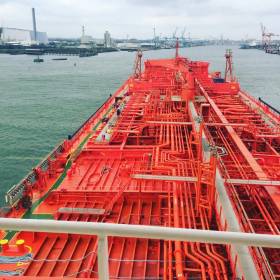
So what is the identity of this tanker?... with this view overlooking the vessel's complex looking cargo tanks pipeline network. The answer to the vessel's identity is that of the MS Simon, a 40,000dwt Liberian flagged oil-chemical bulk liquids tanker.

The vessel had berthed in Dublin Port nine days ago with a cargo of molasses from Guatemala in Central America. This followed a crossing of the Atlantic, where MS Simon made an en-route call to Amsterdam prior to docking in Dublin Port.

The 176m long vessel discharged the molasses at a northside fuel jetty before shifting to the south bank along Deepwater Quay. 

At this same berth (No.47) is where previously Iver Ability made several calls during the prolonged anchorage that arose following a 'cargo reaction' incident in transporting bitumen in the port.

The final port call was prior to the festive season. On that occasion a change of certain personnel of the 129m vessel was undertaken. 

Late last month Iver Ability finally departed Dublin Bay bound for the Netherlands. 

On completion of duties that is of the MS Simon, the tanker departed the capital this week. On Thursday the ship was monitored offshore of the Scottish coast. At that stage the tanker was off Islay, the southernmost of the Inner Hebrideas.

Published in Dublin Port

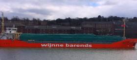
#Scotline – Scotline the short-sea timber products operator recently took a time-charter of Lady Ariane which berthed in Wicklow Port today, writes Jehan Ashmore.

The box shaped singledecker had sailed from the Swedish port of Varberg. The Scandinavian port that firmly established Scotline as an operator from the late 1970’s in the transportation of forest-product cargo of logs from Inverness.

In the present day, the company are responsible for transporting a high percentage of all softwood (packaged timber) into the UK through operating liner services. This includes operations to Ireland.

The time charter of Lady Ariane is from Dutch short-sea operator, Wijnne Barends. Also added to the fleet is Scot Leader which was recently acquired and brings the fleet total to 12 vessels. 

In regards to Wijnne Barends they are based in Delfzijl. The North Sea port is where the asphalt/bitumen tanker Iver Ability is bound to.

The red-hulled ship anchored in Dublin drew much public attention following months spent offshore following a ‘reaction’ during transport of bitumen in Dublin Port last summer.

Iver Ability was monitored yesterday by Afloat while transiting the Strait of Dover. At it’s narrowest point the distance of the Strait is a mere 33.3 kilometres (20.7 miles).

On a daily basis there is around 400 vessels transiting through the Strait, the world’s busiest channel. Asides ships of many types there are ferries criss-crossing between the Port of Dover (see record freight) and the French ports of Calais and Dunkerque.

This afternoon the tanker is at anchorage of the West Frisian Islands. The archipelago lies off the approaches to the Ems Estuary that leads to Delfzijl.

Published in Ports & Shipping

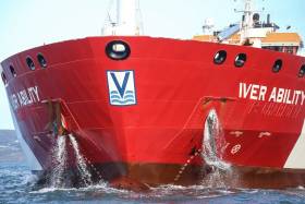
Iver Ability, the red hulled ship, anchored in Dublin Bay since August, left its six–month mooring yesterday, bound for the Dutch Port of Delfzijl.

The long term anchorage of the ship followed a 'reaction' onboard the Asphalt/Bitumen tanker during her transport of Bitumen into Dublin Port this summer. 

The ship cut a lonely sight over Christmas 2016, as 'discussions with charterers' for a port of discharge for the vessel’s cargo continued.

While at anchorage in Dublin, the ship was fully operational with all seafarers performing normal duties and standard crew changes taking place, according to the ship's managers.

Published in Ports & Shipping

Dublin Bay

Dublin Bay on the east coast of Ireland stretches over seven kilometres, from Howth Head on its northern tip to Dalkey Island in the south. It's a place most Dubliners simply take for granted, and one of the capital's least visited places. But there's more going on out there than you'd imagine.

The biggest boating centre is at Dun Laoghaire Harbour on the Bay's south shore that is home to over 1,500 pleasure craft, four waterfront yacht clubs and Ireland's largest marina.

The bay is rather shallow with many sandbanks and rocky outcrops, and was notorious in the past for shipwrecks, especially when the wind was from the east. Until modern times, many ships and their passengers were lost along the treacherous coastline from Howth to Dun Laoghaire, less than a kilometre from shore.

The Bay is a C-shaped inlet of the Irish Sea and is about 10 kilometres wide along its north-south base, and 7 km in length to its apex at the centre of the city of Dublin; stretching from Howth Head in the north to Dalkey Point in the south. North Bull Island is situated in the northwest part of the bay, where one of two major inshore sandbanks lie, and features a 5 km long sandy beach, Dollymount Strand, fronting an internationally recognised wildfowl reserve. Many of the rivers of Dublin reach the Irish Sea at Dublin Bay: the River Liffey, with the River Dodder flow received less than 1 km inland, River Tolka, and various smaller rivers and streams.

Dublin Bay FAQs

There are approximately ten beaches and bathing spots around Dublin Bay: Dollymount Strand; Forty Foot Bathing Place; Half Moon bathing spot; Merrion Strand; Bull Wall; Sandycove Beach; Sandymount Strand; Seapoint; Shelley Banks; Sutton, Burrow Beach

There are slipways on the north side of Dublin Bay at Clontarf, Sutton and on the southside at Dun Laoghaire Harbour, and in Dalkey at Coliemore and Bulloch Harbours.

Dublin Bay is administered by a number of Government Departments, three local authorities and several statutory agencies. Dublin Port Company is in charge of navigation on the Bay.

Dublin Bay is approximately 70 sq kilometres or 7,000 hectares. The Bay is about 10 kilometres wide along its north-south base, and seven km in length east-west to its peak at the centre of the city of Dublin; stretching from Howth Head in the north to Dalkey Point in the south.

Dun Laoghaire Harbour on the southside of the Bay has an East and West Pier, each one kilometre long; this is one of the largest human-made harbours in the world. There also piers or walls at the entrance to the River Liffey at Dublin city known as the Great North and South Walls. Other harbours on the Bay include Bulloch Harbour and Coliemore Harbours both at Dalkey.

There are two marinas on Dublin Bay. Ireland's largest marina with over 800 berths is on the southern shore at Dun Laoghaire Harbour. The other is at Poolbeg Yacht and Boat Club on the River Liffey close to Dublin City.

Car and passenger Ferries operate from Dublin Port to the UK, Isle of Man and France. A passenger ferry operates from Dun Laoghaire Harbour to Howth as well as providing tourist voyages around the bay.

Dublin Bay has two Islands. Bull Island at Clontarf and Dalkey Island on the southern shore of the Bay.

The River Liffey flows through Dublin city and into the Bay. Its tributaries include the River Dodder, the River Poddle and the River Camac.

Dollymount, Burrow and Seapoint beaches

Approximately 1,500 boats from small dinghies to motorboats to ocean-going yachts. The vast majority, over 1,000, are moored at Dun Laoghaire Harbour which is Ireland's boating capital.

In 1981, UNESCO recognised the importance of Dublin Bay by designating North Bull Island as a Biosphere because of its rare and internationally important habitats and species of wildlife. To support sustainable development, UNESCO’s concept of a Biosphere has evolved to include not just areas of ecological value but also the areas around them and the communities that live and work within these areas. There have since been additional international and national designations, covering much of Dublin Bay, to ensure the protection of its water quality and biodiversity. To fulfil these broader management aims for the ecosystem, the Biosphere was expanded in 2015. The Biosphere now covers Dublin Bay, reflecting its significant environmental, economic, cultural and tourism importance, and extends to over 300km² to include the bay, the shore and nearby residential areas.

On the Southside at Dun Laoghaire, there is the National Yacht Club, Royal St. George Yacht Club, Royal Irish Yacht Club and Dun Laoghaire Motor Yacht Club as well as Dublin Bay Sailing Club. In the city centre, there is Poolbeg Yacht and Boat Club. On the Northside of Dublin, there is Clontarf Yacht and Boat Club and Sutton Dinghy Club. While not on Dublin Bay, Howth Yacht Club is the major north Dublin Sailing centre.

© Afloat 2020