Menu

Ireland's sailing, boating & maritime magazine

Dublin Bay Boating News and Information

Displaying items by tag: Lough Ennell

A €60 million project to improve the quality of inland waters has been initiated by Minister for Marine Charlie McConalogue.

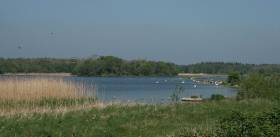
McConalogue was on the shores of Lough Ennell in Co Westmeath on Thursday (March 7) to mark the new programme with junior ministers Pippa Hackett and Malcolm Noonan.

The €60 million “Farming for Water” project aims to improve water quality at local, catchment and national levels.

The project is a collaborative approach between the Department of Agriculture, Food and the Marine and the Department of Housing, Local Government and Heritage, working in partnership with the agri-food industry to improve water quality.

McConalogue’s department will support the project through funding of €50 million for participating farmers, co-funded by the national exchequer and the EU.

It has set a target of involving 15,000 farmers in priority areas nationally. The Department of Housing, Local Government and Heritage will provide administrative support for the project to the value of €10 million.

The European Innovation Partnership (EIP-AGRI) project has established an operational group, run by the Local Authority Waters Programme (LAWPRO), in partnership with Teagasc, Dairy Industry Ireland (DII) and Bord Bia.

This will support a number of targeted actions at farm level to improve water quality.

“Our rivers, lakes, estuaries and bays are at the heart of what we value about Ireland’s environment. Improving the quality of their waters is vital – not just for nature and wildlife, but also for public health and wellbeing,” Noonan said.

“It is testament to the commitment of Government departments and the agricultural sector in taking ownership of their role in improving water quality,” Noonan noted.

Published in Inland Waterways
Tagged under

#Angling - Inland Fisheries Ireland (IFI) is currently carrying out a fish stock survey on Lough Ennell, near Mullingar, to assess the current status of the fish populations in the lake.

The survey takes place from today (Tuesday 19 September) till the Friday (22 September) and will involve netting throughout the lake undertaken by IFI staff from Limerick and research staff from Citywest headquarters crewing a total of two boats.

It’s expected that the survey will provide a range of information on the fish stocks in the lake, such as size distributions of fish captured, age and growth information for all species, diet of selected species, and catch per unit effort (CPUEs) for each fish species.

Samples for genetic analyses of brown trout and pike will also be taken. The information collected will assist IFI in managing, conserving and monitoring any changes in the fish stocks of the lake.

The survey crews will be very visible on the lake and all sets of nets will be marked with distinctive buoys labelled ‘IFI Survey’. Any anglers or other lake users are asked to be vigilant if out and about on the lake to avoid snagging in the nets.

Further details on the background of this survey are available on the IFI website.

Published in Angling

Dublin Bay

Dublin Bay on the east coast of Ireland stretches over seven kilometres, from Howth Head on its northern tip to Dalkey Island in the south. It's a place most Dubliners simply take for granted, and one of the capital's least visited places. But there's more going on out there than you'd imagine.

The biggest boating centre is at Dun Laoghaire Harbour on the Bay's south shore that is home to over 1,500 pleasure craft, four waterfront yacht clubs and Ireland's largest marina.

The bay is rather shallow with many sandbanks and rocky outcrops, and was notorious in the past for shipwrecks, especially when the wind was from the east. Until modern times, many ships and their passengers were lost along the treacherous coastline from Howth to Dun Laoghaire, less than a kilometre from shore.

The Bay is a C-shaped inlet of the Irish Sea and is about 10 kilometres wide along its north-south base, and 7 km in length to its apex at the centre of the city of Dublin; stretching from Howth Head in the north to Dalkey Point in the south. North Bull Island is situated in the northwest part of the bay, where one of two major inshore sandbanks lie, and features a 5 km long sandy beach, Dollymount Strand, fronting an internationally recognised wildfowl reserve. Many of the rivers of Dublin reach the Irish Sea at Dublin Bay: the River Liffey, with the River Dodder flow received less than 1 km inland, River Tolka, and various smaller rivers and streams.

Dublin Bay FAQs

There are approximately ten beaches and bathing spots around Dublin Bay: Dollymount Strand; Forty Foot Bathing Place; Half Moon bathing spot; Merrion Strand; Bull Wall; Sandycove Beach; Sandymount Strand; Seapoint; Shelley Banks; Sutton, Burrow Beach

There are slipways on the north side of Dublin Bay at Clontarf, Sutton and on the southside at Dun Laoghaire Harbour, and in Dalkey at Coliemore and Bulloch Harbours.

Dublin Bay is administered by a number of Government Departments, three local authorities and several statutory agencies. Dublin Port Company is in charge of navigation on the Bay.

Dublin Bay is approximately 70 sq kilometres or 7,000 hectares. The Bay is about 10 kilometres wide along its north-south base, and seven km in length east-west to its peak at the centre of the city of Dublin; stretching from Howth Head in the north to Dalkey Point in the south.

Dun Laoghaire Harbour on the southside of the Bay has an East and West Pier, each one kilometre long; this is one of the largest human-made harbours in the world. There also piers or walls at the entrance to the River Liffey at Dublin city known as the Great North and South Walls. Other harbours on the Bay include Bulloch Harbour and Coliemore Harbours both at Dalkey.

There are two marinas on Dublin Bay. Ireland's largest marina with over 800 berths is on the southern shore at Dun Laoghaire Harbour. The other is at Poolbeg Yacht and Boat Club on the River Liffey close to Dublin City.

Car and passenger Ferries operate from Dublin Port to the UK, Isle of Man and France. A passenger ferry operates from Dun Laoghaire Harbour to Howth as well as providing tourist voyages around the bay.

Dublin Bay has two Islands. Bull Island at Clontarf and Dalkey Island on the southern shore of the Bay.

The River Liffey flows through Dublin city and into the Bay. Its tributaries include the River Dodder, the River Poddle and the River Camac.

Dollymount, Burrow and Seapoint beaches

Approximately 1,500 boats from small dinghies to motorboats to ocean-going yachts. The vast majority, over 1,000, are moored at Dun Laoghaire Harbour which is Ireland's boating capital.

In 1981, UNESCO recognised the importance of Dublin Bay by designating North Bull Island as a Biosphere because of its rare and internationally important habitats and species of wildlife. To support sustainable development, UNESCO’s concept of a Biosphere has evolved to include not just areas of ecological value but also the areas around them and the communities that live and work within these areas. There have since been additional international and national designations, covering much of Dublin Bay, to ensure the protection of its water quality and biodiversity. To fulfil these broader management aims for the ecosystem, the Biosphere was expanded in 2015. The Biosphere now covers Dublin Bay, reflecting its significant environmental, economic, cultural and tourism importance, and extends to over 300km² to include the bay, the shore and nearby residential areas.

On the Southside at Dun Laoghaire, there is the National Yacht Club, Royal St. George Yacht Club, Royal Irish Yacht Club and Dun Laoghaire Motor Yacht Club as well as Dublin Bay Sailing Club. In the city centre, there is Poolbeg Yacht and Boat Club. On the Northside of Dublin, there is Clontarf Yacht and Boat Club and Sutton Dinghy Club. While not on Dublin Bay, Howth Yacht Club is the major north Dublin Sailing centre.

© Afloat 2020