Displaying items by tag: Maritime & Coastguard Agency
On the Thames Estuary and hidden below the waves, reports BBC News, is one of London's most unlikely tourist destinations.
We've travelled about 30 minutes, along with a handful of day trippers from Southend, into the estuary.
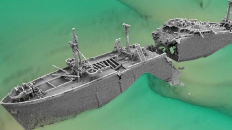
Slowly, a set of masts sticking out from the grey waves come into view. This is the SS Richard Montgomery, beached on a sandbank in 1944.
The problem is that the wreck holds 1,400 tonnes of explosives - which could detonate.
The ship is decaying and if the cargo explodes, a huge tidal wave could blast towards the Kent and Essex shorelines and onwards towards the capital.
Richard Bain is from Jetstream Tours, which is seeing an increased interest in trips to see the masts of the SS Richard Montgomery.
For more on the wreck with an exclusion zone around it is located not far from shipping lanes using the Port of London.
Suspended Jail Sentence for NI Passenger Boat Owner
#The Sarah May III is a Princess 55 motor cruiser owned and operated by James Grahame Paul Stronge. The vessel is coded under the code of Practice for the Safety of Small commercial Vessels to carry not more than twelve passengers and three crew according to a Maritime & Coastguard Agency statement released today.
On 28th January 2012, the Sarah May III was chartered for a days outing by the Northern Ireland Volunteers under a contract with Londonderry Council.
A report of overloading was made to the Maritime and Coastguard Agency (MCA) and it was confirmed that the vessel had indeed sailed with twenty four persons onboard including twenty two passengers of whom four were children.
The MCA investigation revealed a number of shortcomings in the safety equipment onboard. There were 21 inflatable lifejackets, which require to be serviced annually. 17 were found not to have been serviced since 2008, some four years earlier.
The vessel was issued a detention notice on 8th February 2012 which prohibited sailing until all of the lifesaving appliances had be serviced. On 17th February 2012 while all of the life jackets and liferafts were ashore, the vessel sailed to Lough Swilly in neighbouring Republic of Ireland, breaching the detention notice.
At Londonderry Crown Court Mr Stronge pleaded guilty on 7th February 2013 to four charges:-
(1) Proceeding to sea with 22 passengers without Sarah May III being surveyed and inspected for a passenger ship certificate.
(2) Proceeding to sea on the 17th February 2012 in breach of a Detention Notice issued on 8th February 2012.
(3) Breach of Merchant Shipping Act 1995 section 100 by sailing with an excessive number of passengers 23 in total and 2 crew, and with insufficient number of lifejackets, 17 of which were outside their required service date and having liferaft space for only 16 persons in the two available liferafts, one of which was outside its service date.
(4) Mr Stronge made a false declaration to the Certifying authority MECAL with regard to the condition of the lifejackets and life rafts.
The trial was continued for statements by prosecution and defence on 7th March 2013 and the judge remanded Mr Stronge in custody pending a sentence hearing on 13th March 2013.
At the sentencing hearing at Londonderry Crown court on 13th March 2013 Mr Stronge was sentenced to 9 months in custody suspended for three years and fined a total of £1500.
His Honour, Judge Grant said;
"You should have been aware of the requirements. These safety requirements are made to mitigate disasters and risks. The public are entitled to expect equipment to be up to date. You are arrogant to assume nothing will happen, I view it as very serious, I recommend that the RYA suspend his certification.
Captain Bill Bennett Area Operations Manager (Survey and Inspection) Northern Ireland for the MCA stated that:-
This operator has previously pleaded guilty to carrying more than twelve passengers. His actions put the lives of all his passengers at risk. A Detention Notice is placed on a ship to prevent it from sailing in an unsafe condition and in the rare case of an owner breaching the terms of the Detention, the MCA will investigate and where appropriate persons will be prosecuted.
Coastguard to Carry Out Irish Sea Windfarm Exercise

The UK's Maritime & Coastguard Agency in conjunction with RWE npower renewables, the RNLI and RAF Search and Rescue, are due to exercise communications, co-ordination and response to a series of mock-maritime incidents in and around the wind turbines at the North Hoyle and Rhyl Flats Offshore Wind Farms on the Irish Sea.
Rhyl Flats Offshore Wind Farm is a 25 turbine wind farm approximately 8 km north east of Llandudno in North Wales. It is Wales' second offshore wind farm and the third offshore wind farm to be built within Liverpool Bay. It has a maximum rated output of 90 MW.
The Exercise is due to take place on Sunday 5th September.
The exercise will be coordinated by Holyhead Coastguard, and involves multiple agencies, including the North Hoyle and Rhyl Flats wind farm operators, maintenance teams and a number of service vessels.
Jim Paton, Rescue Co-ordination Centre manager at Holyhead Coastguard said:
"We are very keen to practise various elements of a search and rescue within a wind farm and to test rescue and evacuation procedures for 'walking wounded' from intermediate and lower platforms of a wind farm tower. With colleagues in the RNLI we will exercise the appointment of the Rhyl RNLI all weather lifeboat as on scene co-ordinator to search the surface sea area for missing people with multiple search units employed.
"We want to be able to test procedures for the rescue and evacuation of persons from a turbine nacelle and with the RAF, test a helicopter evacuation of a casualty from the nacelle of a wind turbine. We will also be exercising winching procedures within a wind farm complex using lifeboats, a helicopter and a wind farm service vessel all working with each other. We expect the exercise to take about four (4) hours from midday to 4.00 pm."
The exercise will begin with Holyhead Coastguard receiving a call reporting a 4x4 vehicle and trailer parked in Rhyl overnight. The first informant will also explain that he had seen two people from this vehicle launching a small boat from the slipway opposite at around 8.00 pm the previous evening, and who haven't been seen since. Additionally the Coastguard will hear about the need for an individual to be airlifted from somewhere within the North Hoyle offshore wind farm .
Jim Paton continued
"As wind farms become larger and more involved; an emergency service such as the Coastguard must be fully aware of the challenges of search and rescue within such complexes when the weather and sea conditions at the time of the incident may be extremely hostile."


