Displaying items by tag: Met Eireann
29 Compete in CH Marine Winter League
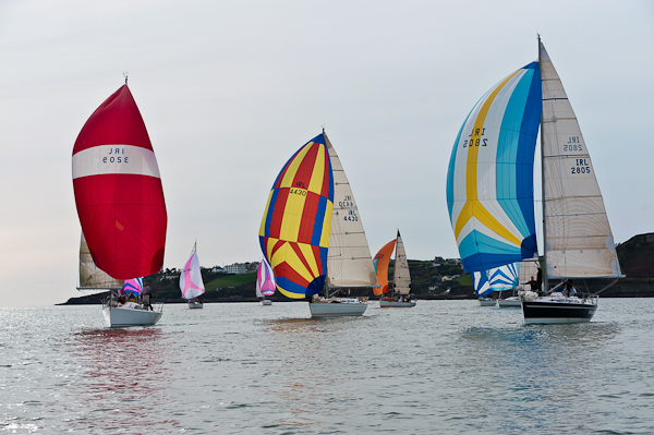
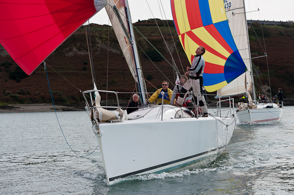
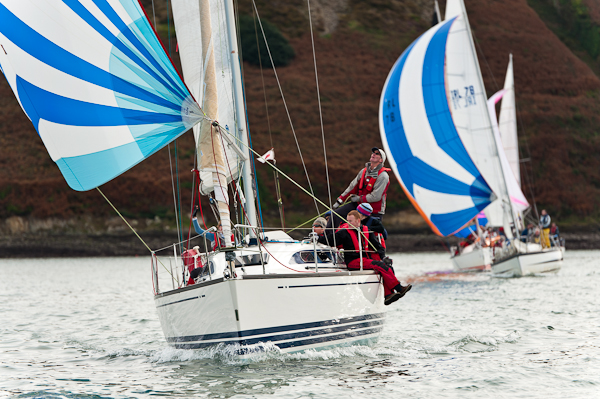
A very good fleet of 29 cruisers came to the line for the first day of the CH Marine Winter league writes Claire Bateman. The first radio sound to be heard was the familiar voice of Afloat correspondent Tom MacSweeney, who was PRO for the occasion, advising the course to be sailed would 99, sailing Classes One and Two together and Classes 3 and White Sail also together. An equally well known voice came back wondering whether there would be water at one particular mark!!
The sea was flat and there was a fitful wintery sun. In spite of the dire forecast that had been promised, one could have been doing a lot worse than enjoying a race in Cork Harbour.
The course turned out to be a good choice as it is divided into three parts and could be shortened after any one of the three rounds. The wind from the ESB stack at Whitegate was showing north west, Met Eireann report from Roches Point was giving 5 knots from the west and the Race Officer for the Laser fleet was setting a course for a south west wind. It was that kind of day.
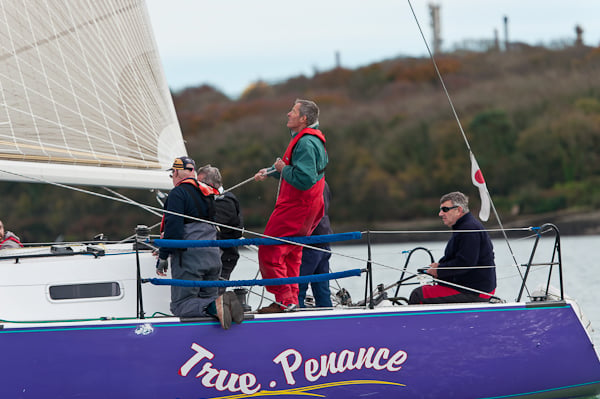
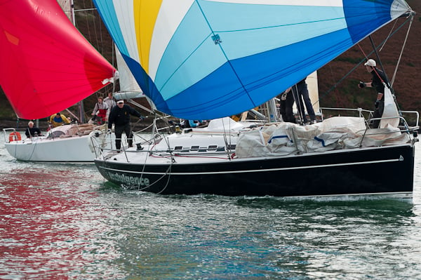
It was an off wind start and True Penance with Joe English on spinnaker got the best start with End Game just behind with Jimmy Nyhan trimming the spinnaker, and Bad Company was looking good as well on the shore side. Magnet was throwing all sorts of shapes at the cage but a was bit slow hoisting her spinnaker.
Classes Three and White Sail sailed one round of the course and Classes One and Two got in two rounds. This worked out very well because as the race progressed the tide was getting stronger and this helped the boats to make it out the harbour against the tide so it all jelled very well.
The prize giving followed at which CH Marine presented the competitors with very seasonal and acceptable bottles of wine and boxes of Cadburys Roses and immediately afterwards the threatened rain began to pour down but as this stage the competitors were not bothered as they were ready to go home having enjoyed a great day of racing.
Photos by Bob Bateman
Indian Summer Forecast-Don't Put That Boat Away Just Yet!
Although we've been writing about how to look after your boat this winter in Afloat's latest issue don't hang up the lifejackets just yet! A late rush of Summer is expected across the country this weekend. Unseasonable high temperatures of up to 22 degrees have been forecast. Get the boat out, it can't last long! The best of the weather can be expected in the mid west. Met Eireann say the Indian Summer could benefit Clare and Galway the best.
MET EIREANN FORECAST : Outlook is for warm dry settled weather in most places. FRIDAY NIGHT: Very mild, humid and misty on Friday night. Dry in many areas apart from some drizzle but there will be rain in parts of Kerry. SATURDAY & SUNDAY: Warm, humid conditions are expected over the weekend and dry in most places. However it looks as if southwestern counties will have a lot of cloud with rain at times on Saturday but this dying away on Sunday. For the rest of the country the weekend looks like being dry and warm with sunshine at times, probably best during Sunday and afternoon temperatures in the high teens or around 20 degrees in parts of the west, very high for early October. Feeling cooler at times near the east coast due to a brisk easterly breeze MONDAY: Dry and bright on Monday with sunshine in many areas and afternoon temperatures a little lower in the mid to high teens but winds lighter than over the weekend, just a moderate easterly breeze.
Met Eireann: Irish Meteorological Service
Our History
 Operational Meteorology might be said to have begun in Ireland on 8 October 1860, when the first 'real time' weather observation was transmitted from Valentia Island in Co. Kerry. Valentia Observatory, as it came to be known, was one of a network of weather stations established around the Irish and British coastlines, by the naval authorities in London, to enable storm warnings to be provided for ships at sea.
For many years after Independence Ireland's needs, as far as weather matters were concerned, continued to be met by the British Meteorological Office. By the mid-1930's, however, it was clear that a new and exciting customer was on the way. It was the requirement to provide accurate weather information for transatlantic aviation that led to the formal establishment of an Irish Meteorological Service in 1936.
The first Director, Austen H. Nagle, was appointed in December of that year, and installed himself in the small offices in St. Andrew's Street in Dublin, which became the first Headquarters of the new Service. In April 1937, the administration of the existing observing network was taken over from the British Authorities; it comprised 4 telegraphic stations (at Malin Head, Blacksod Point, Roches Point and Birr), 18 climatological stations, 172 rainfall stations, and Valentia Observatory, which was the only station at the time to be manned by official personnel.
In its early stages, the new Service received continuing help from the British Authorities. This assistance was in the form of staff seconded from London to work at Foynes, in Co. Limerick, from where flying boats had just begun to operate. Included in their number were several who were later to become well known internationally; notably Hubert Lamb, the climatologist and Arthur Davies, Secretary General of the World Meteorological Organisation for nearly 30 years. By 1941, however, the Service's own recruits had been fully trained, and the organisation was able to begin satisfying the increasing demands for weather information from its own resources.
Forecasting for aviation, first at Foynes and later at Shannon and Dublin Airports, was the major preoccupation of the early years. By the late 1940's, however, the Service had broadened its activities. In 1948, for the first time, it assumed responsibility for the weather forecasts broadcast by Radio Éireann, which had been provided from London in the interim. In 1952 it began to supply forecasts to the daily newspapers and 1961 saw the opening of the new Central Analysis and Forecast Office in the Headquarters premises, now housed at 44 Upper O'Connell Street, Dublin. Live presentation by Met Éireann forecasters of the weather on Teilifis Eireann commenced in early 1962.
 Radar Antenna at Shannon AirportThe late 1940's and the 1950's were a time of rapid expansion for the Service. This period saw the establishment of a balanced nation-wide network of observing stations, manned on a full-time basis by Meteorological Service personnel. The climatological and rainfall observing networks were greatly enhanced, thanks largely to the willing co-operation of the Garda authorities around the country and the assistance of other Government Departments and State-sponsored bodies. At Valentia Observatory, which had moved to a mainland site near Cahirciveen in 1892, upper air radiosonde measurements began and a wide range of geophysical measurements and environmental monitoring activities was introduced.
Meanwhile, the Service offered an expanding range of forecast and climatological information to the public and to specialised interests. A notable development was the inauguration of tape recorded telephone forecasts during the 1960's, the precursor of today's Weatherdial. The reception of satellite images began in the late 1960's at Shannon Airport and in the 1970's, the Meteorological Service might be said to have come of age by entering the computer era. Initially, the new machines were employed for communication purposes, but shortly afterwards the computers were used for the relatively new technique of numerical weather prediction.
Throughout its history, the Meteorological Service and its staff played an active role in the development of meteorology on the international scene. Ireland became a full member of the World Meteorological Organisation shortly after its establishment in the early 1950's and was later a founder member of both the European Centre for Medium Range Weather Forecasts and the European Meteorological Satellite Organisation, EUMETSAT. More recently, the Service has been active in the formation of other co-operative agencies like EUMETNET and ECOMET. Particularly beneficial to the organisation has been its membership since 1989 of HIRLAM, a co-operative venture between the Scandinavian countries and several other European Meteorological Services for the development of a numerical model for short-range forecasting.
Met eireann Headquarters ImageThe modern era of the Meteorological Service might be said to date from its occupation of the new Headquarters Building in Glasnevin in 1979, a development which for the first time allowed all the Dublin based Divisions to be housed under the same roof. It was around this time too, that the Service reached its peak in terms of staffing, with a total of 342 in 1980. The intervening years have seen a gradual reduction in staff numbers to the present level of 230, a development brought about mainly by the introduction of automated methods for many repetitive tasks, and by on-going review of our priorities with regard to weather observations.
Since the 1990s, in common with its sister organisations in most other European countries, the service has adopted a more commercial approach to the provision of services to its customers,in an effort to try to increase revenue and thus lighten the financial burden on the tax-payer. This spirit of commercial awareness, however, has been combined with an enhancement of the Service's public service role in areas where this has seemed desirable, most notably perhaps by the introduction of Severe Weather Alerts and by co-operation in the monitoring of stratospheric and tropospheric ozone
In March of 1996, its 60th year of operation, the Meteorological Service adopted the new title Met Éireann, with the aim of establishing a well-focused corporate identity in the public mind. Proud of its record of public service, its development of the national meteorological infrastructure and its contribution to the science of meteorology, Met Éireann looks forward with confident optimism to the challenges that lie ahead.
Directors of Met Éireann, 1936-present
1936-1948 Austen H. Nagle
1948-1964 Mariano Doporto
1965-1978 P.M. Austin Bourke
1978-1981 P. Kilian Rohan
1981-1988 Donal L. Linehan
1989-present Declan J. Murphy
Met Éireann Headquarters, Glasnevin Hill, Dublin 9
Tel: +353-1-8064200
Fax: +353-1-8064247
General Forecasting Division
Tel: +353-1- 8064255
Fax: +353-1- 8064275
Note: Provision of forecasts is subject to a fee.
Climate Enquiries Office
Tel: +353-1- 8064260
Fax: +353-1- 8064216
Note: Provision of services is subject to a fee.
Commercial Division
Tel: +353-1-8064244
Fax: +353-1-8064247
Freedom of Information Officer
Tel: +353-1-8064295
Fax: +353-1-8064275
Met Éireann Aviation Services, Shannon Airport Co. Clare
Tel: +353-61-712958
Fax: +353-61-712960
Met Éireann Valentia Observatory, Cahirciveen Co. Kerry
Tel: +353-66-9473460
Fax: +353-67-9472242
Met Eireann: Irish Meteorological Service, Glasnevin Hill, Dublin 9


