Menu

Ireland's sailing, boating & maritime magazine

Dublin Bay Boating News and Information

Displaying items by tag: Museum tallship

#ShiftingBerths – One of Dublin’s floating tourist visitor attractions on the Liffey, tallship Jeanie Johnston which reopened after a historic drydocking, has still yet to return to her customary city-centre berth, writes Jehan Ashmore.

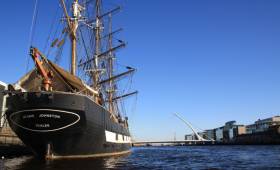
Jeanie Johnston a replica of a 19th century famine-emigrant tallship had been expected to be towed back to her berth on Custom House Quay. The reason is due to temporary interim closures of the Samuel Becket swing-bridge because of maintenance. Before that the barque as planned was initially given a temporary berth just beyond the Tom Clark lift-bridge (see report photo).

As previously reported on Afloat Jeanie Johnston was to shift berths to Sir John Rogerson Quay. This has since been carried out with tours of the tallship currently available along this southside quay. The tallship is downriver of the distinctive orange coloured Diving Bell which was preserved in recent years. 

The museum tallship operator website advises that tour tickets remain on sale at Custom House Quay. A walk of around five minutes from Sir John Rogersons Quay.

The tours explains the role of the original Jeanie Johnston that made 16 emigrant journeys from Ireland to North America between 1847 and 1855. In that time, Jeanie Johnston transported over 2,500 people with no loss of life.

After March 10th, the tours will commence when the ‘Jeanie’ shift berths upriver. This will involve the final leg of a short hop back ‘home’ to the northside’s Custom House Quay.

Jeanie Johnston, the replica that is was built in Blennerville outside Tralee, Co. Kerry. In 2003 she sailed to North America on a tour of ports along the US and Canadian east coast. The historic re-enactment drew considerable positive media attention overseas. This in stark contrast to domestic criticism before the tour arising over high cost-overuns in constructing the replica.

Following her return from the North American tour she made several visits to ports in western Europe. Also day sails in Dublin Bay were run before her short-lived sailing career ended.

The barque was acquired in 2005 by her previous owners the Dublin Docklands Development Authority. The DDDA began using the tallship as a museum ship for the next five years.

Since 2010 Galway-based company Aiseanna Mara Teoranta were appointed to continue operating the ship as a museum.

Published in Tall Ships

#TallshipTimes - The reopening of a Dublin city centre tourist visitor attraction, the tallship Jeanie Johnston has been deferred by a week, writes Jehan Ashmore.

As reported earlier this week the replica of the 19th century famine-emigrant tallship followed a historic end of era drydocking in the port. The tallship was to have reopened yesterday following a tow to a temporary berth. 

It transpires the reopening of tours explaining the emigrant role of the original ship during the Irish famine to north America will begin next Friday, 24 February. This been despite the barque's recent return to a routine berth at Custom House Quay following planned drydocking maintenance. 

During a visit to the Jeanie Johnston by Afloat to the drydock, it was clearly evident towards the stern that exposed timber framework remained along with just half a mizzen mast in situ. As for the graving dry-dock dating to 1957, the largest such working facility in the state and in the capital at 200m long is to be decommissioned by the Dublin Port Company.

This is to facilitate DPC’s plans for much needed quay frontage and cargo space for the €227m Alexandra Redevelopment Project (ABR) project. This will be phase one of the port’s Masterplan: 2012-2040.

Following three days of public information days held this week in local community venues on the Masterplan Review, those intending to consult can still do until Tuesday 7th March 2017. Dublin Port is inviting submissions from all those with an interest in the future development of the Port.

DPC have published a Masterplan Review 2017 Consultation Paper and an Environmental Report Consultation Paper. Both documents can also be viewed in hard copy (Monday to Friday, 9am to 4pm) at the offices of Dublin Port Company, Port Centre, Alexandra Road, Dublin 1.

Submissions may be made to Dublin Port Company during the public consultation period in any of the following ways by clicking this information link here.

Published in Tall Ships

Dublin Bay

Dublin Bay on the east coast of Ireland stretches over seven kilometres, from Howth Head on its northern tip to Dalkey Island in the south. It's a place most Dubliners simply take for granted, and one of the capital's least visited places. But there's more going on out there than you'd imagine.

The biggest boating centre is at Dun Laoghaire Harbour on the Bay's south shore that is home to over 1,500 pleasure craft, four waterfront yacht clubs and Ireland's largest marina.

The bay is rather shallow with many sandbanks and rocky outcrops, and was notorious in the past for shipwrecks, especially when the wind was from the east. Until modern times, many ships and their passengers were lost along the treacherous coastline from Howth to Dun Laoghaire, less than a kilometre from shore.

The Bay is a C-shaped inlet of the Irish Sea and is about 10 kilometres wide along its north-south base, and 7 km in length to its apex at the centre of the city of Dublin; stretching from Howth Head in the north to Dalkey Point in the south. North Bull Island is situated in the northwest part of the bay, where one of two major inshore sandbanks lie, and features a 5 km long sandy beach, Dollymount Strand, fronting an internationally recognised wildfowl reserve. Many of the rivers of Dublin reach the Irish Sea at Dublin Bay: the River Liffey, with the River Dodder flow received less than 1 km inland, River Tolka, and various smaller rivers and streams.

Dublin Bay FAQs

There are approximately ten beaches and bathing spots around Dublin Bay: Dollymount Strand; Forty Foot Bathing Place; Half Moon bathing spot; Merrion Strand; Bull Wall; Sandycove Beach; Sandymount Strand; Seapoint; Shelley Banks; Sutton, Burrow Beach

There are slipways on the north side of Dublin Bay at Clontarf, Sutton and on the southside at Dun Laoghaire Harbour, and in Dalkey at Coliemore and Bulloch Harbours.

Dublin Bay is administered by a number of Government Departments, three local authorities and several statutory agencies. Dublin Port Company is in charge of navigation on the Bay.

Dublin Bay is approximately 70 sq kilometres or 7,000 hectares. The Bay is about 10 kilometres wide along its north-south base, and seven km in length east-west to its peak at the centre of the city of Dublin; stretching from Howth Head in the north to Dalkey Point in the south.

Dun Laoghaire Harbour on the southside of the Bay has an East and West Pier, each one kilometre long; this is one of the largest human-made harbours in the world. There also piers or walls at the entrance to the River Liffey at Dublin city known as the Great North and South Walls. Other harbours on the Bay include Bulloch Harbour and Coliemore Harbours both at Dalkey.

There are two marinas on Dublin Bay. Ireland's largest marina with over 800 berths is on the southern shore at Dun Laoghaire Harbour. The other is at Poolbeg Yacht and Boat Club on the River Liffey close to Dublin City.

Car and passenger Ferries operate from Dublin Port to the UK, Isle of Man and France. A passenger ferry operates from Dun Laoghaire Harbour to Howth as well as providing tourist voyages around the bay.

Dublin Bay has two Islands. Bull Island at Clontarf and Dalkey Island on the southern shore of the Bay.

The River Liffey flows through Dublin city and into the Bay. Its tributaries include the River Dodder, the River Poddle and the River Camac.

Dollymount, Burrow and Seapoint beaches

Approximately 1,500 boats from small dinghies to motorboats to ocean-going yachts. The vast majority, over 1,000, are moored at Dun Laoghaire Harbour which is Ireland's boating capital.

In 1981, UNESCO recognised the importance of Dublin Bay by designating North Bull Island as a Biosphere because of its rare and internationally important habitats and species of wildlife. To support sustainable development, UNESCO’s concept of a Biosphere has evolved to include not just areas of ecological value but also the areas around them and the communities that live and work within these areas. There have since been additional international and national designations, covering much of Dublin Bay, to ensure the protection of its water quality and biodiversity. To fulfil these broader management aims for the ecosystem, the Biosphere was expanded in 2015. The Biosphere now covers Dublin Bay, reflecting its significant environmental, economic, cultural and tourism importance, and extends to over 300km² to include the bay, the shore and nearby residential areas.

On the Southside at Dun Laoghaire, there is the National Yacht Club, Royal St. George Yacht Club, Royal Irish Yacht Club and Dun Laoghaire Motor Yacht Club as well as Dublin Bay Sailing Club. In the city centre, there is Poolbeg Yacht and Boat Club. On the Northside of Dublin, there is Clontarf Yacht and Boat Club and Sutton Dinghy Club. While not on Dublin Bay, Howth Yacht Club is the major north Dublin Sailing centre.

© Afloat 2020